Posts Tagged ‘newtown creek’
these views
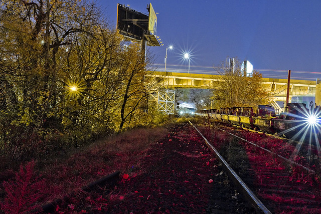
Welcome to the Montauk Cutoff, Long Island City.

– photo by Mitch Waxman
Recently, one found himself hitting the tracks just before sunrise. I was there with sanction, accompanied by an MTA employee and entirely “legal.” It should be mentioned, again, that illegal trespass is against a humble narrator’s code, and like a vampire – I need to be invited in to do my thing. You also really, really, don’t want to get caught trespassing up here by the railroad cops, by the way. You also really, really, don’t want to meet the sort of person who camps out along railroad tracks in LIC when you’re all alone in the wee hours.
The Montauk Cutoff in Long Island City was designed to connect the North Shore line with the Montauk Line. The Montauk Line uses the tracks which follow the shoreline of Newtown Creek through Queens, eventually intersecting with the Bushwick Branch and both head for the rail yard at Fresh Pond. The elevated trackway of the Montauk Cutoff crosses Skillman, 49th, 50th, 51st, and Borden Avenues, whereupon it meets a rail bridge called Cabin M which spans Newtown Creek’s tributary Dutch Kills.
The North Shore line used what are approximately the modern LIRR passenger tracks, give or take a few yards, which transverse the Sunnyside Yards and head through Woodside on their way east. The Montauk Cutoff was built for freight, as were the North Shore and Montauk Lines. Passenger service was always a loser for the LIRR. Modern day freight on the LIRR is handled by the New York & Atlantic company.
– photo by Mitch Waxman
The first discussion, which I’ve been able to find at least, about building LIC’s Montauk Cutoff was in 1906 – as part of a series of railroad projects either proposed or already under construction at the start of the 20th century by the Pennsylvania Railroad Company – projects which included Penn Station and Sunnyside Yard. Other documents I’ve examined state that the LIRR was paying taxes to New York State as early as 1912 on the Montauk Cutoff, which suggests that it came into service around the same time that the Sunnyside Yards came online. The surrounding Degnon Terminal wasn’t far behind the rail complex, either, with the Loose Wiles factory and other mega factories opening in the 1920’s.
As is always mentioned, old Mitch ain’t no authority on the whole railroad thing. If there’s something wrong in my little summary, please let me know in the comments and corrections or an errata will be incorporated. I can speak pretty intelligently about the maritime/locomotive complex around Newtown Creek, but I’ll admit to having vast gaps on the particular subject of the iron road. That was my pal Bernie Ente’s area of expertise.
For a historic series of shots, maps, and technical descriptions of anything involving the LIRR, you are going to have to visit the fairly excellent trainsarefun.com. Here’s their Montauk Cutoff Page.
Another set of maps and historic shots can be accessed at an equally fantastic site called arrts-arrchives.com. Here’s their Montauk Cutoff page.
I’ve written about the Smiling Hogshead Ranch before, which sits on the interchange between the Degnon Terminal Railway and the Montauk Cutoff, over at my old Brownstoner Queens column.

– photo by Mitch Waxman
The view from up on the Montauk Cutoff is unique. That big parking lot at the bottom of the shot above is a UPS shipping center, the one on 49th avenue. Rearing above and behind it is the Queens Midtown Expressway section of the Long Island Expressway, which arches up and over Dutch Kills some 106 feet from its beginning at the Queens Midtown Tunnel – which is around a half mile away.
My MTA companion and I met up at the Smiling Hogshead Ranch at 5:30 in the morning to get these shots, which gave me a solid hour to work in absolute pitch darkness up on the tracks. The shots in today’s post are obviously tripod shots, and long exposures. Leaving the shutter open for 20-30 seconds at a pop, you can gather a tremendous amount of light and color, but the hot spots of electric street lighting always cause certain problems. Compensation for this is to move the aperture into “hyperfocal” range, f11 and narrower, which is counterintuitive for night shots but nevertheless effective. It also produces those neat little star bursts around the lights.

– photo by Mitch Waxman
So, why was I out on a chilly November morning with an MTA property manger, walking on a century old rail spur in Long Island City?
The MTA has decided to “abandon” this line. Abandon doesn’t mean the same thing in “railroad” as in does in english. It means that the agency has no current plans for the line and wishes to free itself of the duties necessitated in maintaining it as functional track. It means that the MTA will retain ownership of the Montauk Cutoff, and can at any time reactivate the pathway should “future use” require it. Given the speed with which rail projects generally move, however, that means a window of at least a couple of decades of inactivity awaits the property no matter what happens.
Accordingly, MTA has issued a “Request for Expressions of Interest,” or RFEI, regarding the Montauk Cutoff and is seeking potential lessees for the space.

– photo by Mitch Waxman
As defined in the RFEI document, the MTA is seeking out creative uses of the land with an eye towards community improvement. The agency has set down a few ground rules for any potential lessee of the site, many of which are quite expensive – such as insurance, utility service – those sorts of things. The property, as defined in the RFEI, includes the Smiling Hogshead Ranch – who currently lease and pay insurance on the parcel in which the community garden is operated.
Before certain web masters start pointing their fingers and shouting “j’accuse” at me while spinning a conspiratorial tale, Smiling Hogshead is indeed associated with Newtown Creek Alliance, as am I. You can absolutely bet that I’m a fan of SHHR’s operations and programming, and friends with a lot of their members. Long Island City needs every bit of green space it can get, which is how I finally get around to explaining why me and the MTA guy were here on the day before Thanksgiving and just before sunrise.

– photo by Mitch Waxman
A “Request for an Expression of Interest”? You can say that I’m interested. I’m interested in seeing this trackway converted over to green space, in much the same way that the Degnon Spur on Pearson and Skillman – a weedy dumping ground and homeless camp – was turned into a lush garden by a group of dedicated volunteers.
Can you imagine what a group like Smiling Hogshead’s could do up here?
If you want to get in on the conversation, or contribute some time and knowledge to the project – shape the future, as it were – whatcha doing on the 2nd of December? A bunch of us are going to attend a “visioning meeting” at Nomad Cycle (47-10 Austell Pl, Queens, NY 11101) which is set to happen between 6:30 and 8:30 p.m.

– photo by Mitch Waxman
My companion and I had discussed the possibility of getting up here in the pre dawn hours, and a couple of previous appointments had to be cancelled on account of weather. We had met on a walk through of the site which MTA had conducted back in October for parties interested in acquiring the land, an excursion which occurred just before solar noon – which is not the most efficacious time to photograph LIC. I made the case to him that a “proper” set of photos would be needed for this project and quite handy to boot, which my new friend at the agency agreed with. Hence, where we were, when we were, and why we met up in the dark on Skillman Avenue on the day before Thanksgiving.
The wrinkle in this potential project is this – it doesn’t necessarily have to become a green space. Anyone can “express interest” in the Montauk Cutoff, and as long as their proposed project meets the requirements set aside by the MTA, it will be considered a viable option.
I see this as being a frankly huge opportunity to create an enormous acreage of green space in an otherwise completely barren industrial area which can be best described as a “devastation of concrete.” My interest in this thing is simple – this property touches Dutch Kills, where the borders of the “abandoned” section ends, which is “my house.”

– photo by Mitch Waxman
The Montauk Cutoff begins at Sunnyside Yard, and at its southeastern edge connects to the M Cabin truss bridge over Dutch Kills which connects to the Blissville Yard, which in turn feeds the tracks that travel under the Greenpoint and Kosciuszko Bridges to Maspeth, Ridgwood, and all points east. The RFEI states that the M Cabin bridge will be opened, and secured in that position, and that a barrier of some sort will be erected at the edge of the Montauk Cutoff’s lot.
Additionally, I cannot begin to, nor have I ever believed that this is the original bridge on this site. I’ve got some Intel that suggests the early 1940’s for its origins, but nothing solid enough to to stick a pin into. The original early 20th century bridge is long gone at any rate.

– photo by Mitch Waxman
I can tell you with some certainty that the nearby DB Cabin rail bridge is from 1919, and is a swing bridge that hasn’t opened since 2002. My pal Bernie, mentioned above as having been THE authoritative source on all things rail around LIC, told me once or twice that two industrial wreckers are required to tow it from either side to open the bridge. The swing bridges motors are non functional, something that has caused no small amount of grief for the EPA’s Superfund investigators. DB Cabin allows access from the Wheelspur Yard to the Blissville Yard and the Montauk Line.
Like I said, Newtown Creek.

– photo by Mitch Waxman
Looking northwards along Dutch Kills, at a scene familiar and loved by long time readers of this – your Newtown Pentacle. That’s the Borden Avenue Bridge, with the LIE above, spanning Dutch Kills. I’ve been writing about this neighborhood for years, it’s one of my favorite locations in New York City. The Montauk Cutoff leads directly to this spot, which in my mind directly connects it to the environmental problems of the Newtown Creek watershed.
Know how I’ve been rattling on for years about “combined sewer outfalls” and the problems presented to the ancient sewer system during rain events? Montauk Cutoff represents an opportunity to create a nearly four acre long green sponge that can drink up a significant amount of the storm water that carries garbage, grease, and poop into this water.

– photo by Mitch Waxman
The Montauk Cutoff. This is a once in a generation opportunity to do something right for the environment in the ruined biome of Long Island City. Every elected official I’ve spoken to about this idea is “into it” although they haven’t made any public declarations yet (too early in the process to bring them in) and recently – Community Board 2’s environmental committee voted to support the use of these tracks as “green infrastructure.”
Want to get involved in the future of the Montauk Cutoff? As mentioned above, a “visioning meeting” which be taking place at LIC’s Nomad Cycle (47-10 Austell Pl, Queens, NY 11101) on December 2nd, between 6:30 and 8:30 p.m.
“follow” me on Twitter- @newtownpentacle
leftward fork
Down Under the Kosciuszko Bridges Onramps – DUKBO, part 2 – in today’s post.

– photo by Mitch Waxman
As described in my last post, a visit to the NYS DOT’s Kosciuszko Bridge project site was arranged for members of the “Stakeholders Advisory Group” that is connected to the project. Community members, business owners, representatives of municipal agencies and elected officialdom, the SAG’s job is to bring concerns to the attention of the project managers of the K Bridge project. Anyone interested in finding out more about the project straight from the source, or who feel that they should be involved, can contact the Community Liason’s office.
There’s all sorts of job opportunities available on the project as well, for those of you involved with the trades, but quite obviously that’s not something a humble narrator can help you out with.

– photo by Mitch Waxman
On the left side of the shot above is the Robert Moses 1939 era “New Meeker Avenue” Bridge, which was rechristened in 1940 as the Kosciuszko Bridge. Its original purpose, as far as Mayor LaGuardia was concerned, was to allow egress for the multitudes of Brooklyn to the 1939 Worlds Fair over in what we refer to as “Flushing Meadow Corona Park.” For Moses, it was the first link in a chain which he originally called the “Brooklyn Queens Connecting Highway” which modernity knows as the Brooklyn Queens Expressway.
Technical note – the Gowanus Expressway actually was the first part of the modern BQE to be built, but my understanding is that Moses didn’t intend for it to be part of the BQE – it was incorporated into the larger expressway when the Verazzano was being built.
That’s my understanding, I might be incorrect, so “grain of salt.”

– photo by Mitch Waxman
The Brooklyn side of the Newtown Creek enjoys a rather shallow firmament, as a craton which underlies this section of western Long Island – essentially an enormous glacial erratic or boulder – is only about sixty to seventy feet below the surface and sits at a fairly oblique angle relative to the land.
The Queens side is basically a giant pile of mud more than a hundred feet deep, and the bedrock craton on the northern or Queens side of the Creek is more difficult to access. The original or 1939 Kosciuszko Bridge piers on the Queens side are essentially founded on concrete blocks floating in this mud. The new bridge will be anchored in the bedrock instead. (This, incidentally, isn’t something I know from the SAG, rather its “history” stuff).
The piles seen above are in various stages of being driven down to the craton – or bedrock.

– photo by Mitch Waxman
As we neared the shoreline of Newtown Creek, I mentioned to several people that this was one of the spots which I had never actually set foot upon. There used to be a carting company here which was… let’s just say that they didn’t like people with cameras wandering around, and that the few times which I did approach their fencelines over the years resulted in my being literally threatened by several mustachioed people with a distinctly Italian variant of the North Brooklyn accent. As I often say, I only run when someone or something is chasing me, and after meeting these fellows I was running.
The metallic box pictured above was a pretty cool thing, however.

– photo by Mitch Waxman
The new Kosciuszko Bridge is going to be a “cable stay” bridge, the first of its kind in NYC. The device pictured above is what the cables will be running through. The cables will leave their anchorage and climb up and over the towers, feeding down to and supporting the roadway over the water. This is a pretty important bit of kit, obviously, as the BQE carries a couple of hundred thousand vehicles a day over Newtown Creek.

– photo by Mitch Waxman
Looking towards West Maspeth’s border with Blissville near Calvary Cemetery, across the lugubrious Newtown Creek. The Queens side of the job is on schedule, but the process isn’t quite as far along on the north shore. You can see the piers which will carry the road, but the towers which will support the cables haven’t been erected yet.
There’s a whole lot of environmental “ugly” in the shot above, the ground to the right is part of the Phelps Dodge State Superfund site. The sediments in this section of the Newtown Creek are rife with organocoppers and all sorts of bad stuff, which is why the water and what lies below is part of the Federal Superfund site, and not too long ago it was determined that the chemical condition of the land at Phelps Dodge was too extreme for it to serve as a parking lot for USPS trucks.

– photo by Mitch Waxman
Looking up the dizzying heights of the two concrete towers of the Brooklyn side, which are still rising. There were gangs of laborers working up there, who are clearly made of sterner stuff than I. I’d need the Fire Department to come rescue me, as paralysis would set in due to the height.

– photo by Mitch Waxman
Looking back towards the south/south west, along the ramps of the Kosciuszko Bridges. You can really see the difference in the two spans’ deck heights in the shot above. The DOT folks tell me that this is to ensure a smoother experience for drivers, as they won’t have to crest quite as high an incline. Additionally, the BQE will no longer compress to three lanes from four and then back to four again on the new bridge. There is also meant to be an entirely dedicated approach to the Long Island Expressway when the job is finished.

– photo by Mitch Waxman
Our visit over, the Stakeholders Advisory Group was escorted back to Meeker Avenue, where we turned in our hard hats and other safety gear.
“follow” me on Twitter- @newtownpentacle
brought up
Down Under the Kosciuszko Bridges Onramps – DUKBO – in today’s post.

– photo by Mitch Waxman
The other day, Tuesday the 17th to be exact, one found himself wearing an orange vest and a hard hat with a Skanska logo on it in Greenpoint, Brooklyn.
I’m a member of the Stakeholders Advisory Group for the Kosciuszko Bridge project, and we had been invited out by the NYS DOT for an inspection of the massive construction site. These are fairly exclusive shots, incidentally, and this post will be the first of two describing what I saw.

– photo by Mitch Waxman
The Kosciuszko project involves not just the construction of a new K bridge, and the demolition of the 1939 original, but the rerouting and redesign of the 2.1 miles of approach roads.
These roads include the Brooklyn Queens Expressway and the notoriously problematic cloverleaf exchange the BQE has with the Long Island Expressway. The project is being run by the NYS Department of Transportation, and executed by a partnership between Skanska, AECOM, and Kiewit. Skanska is the managing partner for the two phase project, the first part of which (half the new bridge, roadwork, and demolition of the original) is budgeted at $550 million.

– photo by Mitch Waxman
It’s a massive Union Labor kind of job, and it seemed that every trade organization was present on site. These fellows were iron workers, installing the rebar which would provide structural support for the concrete deck of the BQE. The concrete guys were getting busy about a quarter of a mile back, incidentally, filling in the steel webbing that these guys were building.

– photo by Mitch Waxman
Another team of laborers were observed lowering structural steel into place on one of the overpasses for the highway. The sections of the new bridge currently under construction are slightly to the east of the current roadway and bridge. When this phase of the project is complete, traffic will be shifted over to it, and the 1939 Kosciuszko and BQE will be demolished.

– photo by Mitch Waxman
Once demolition is complete, phase two will see the westerly half of the new Kosciuszko and BQE built. According to the officials from DOT we were with, the project is slightly ahead of schedule and they are confident they’ll meet the 2017 goal date for the opening of the new bridge.

– photo by Mitch Waxman
The ramp leading to the bridge is nearing Newtown Creek, but isn’t quite there yet. The ramps sit on a series of concrete piers supported by columns which rise hundreds of feet from a section of DUKBO which I’ve often referred to as the “Poison Cauldron.” Down below, there’s a series of realigned local streets which are currently off limits due to the construction.

– photo by Mitch Waxman
Looking back to the south, the construction guys were hard at work. This is a massive undertaking, the sort of thing you don’t see that often in New York City, or at least not since Robert Moses was kicked out of power.

– photo by Mitch Waxman
Down on “used to be Cherry Street” we headed north towards Newtown Creek, pausing periodically for the laborers to finish up a task. Above, a crew was moving soil around, and grading the surface.

– photo by Mitch Waxman
The ramp for the BQE comes into view as you approach “used to be Anthony Street.” The new bridge will be considerably closer to the ground than the original. The 1939 bridge was built with maritime shipping in mind, and it’s altitude accommodated the height of smoke stacks typical of ocean going military and cargo ships.

– photo by Mitch Waxman
Under the ramp, you can see the progress that the triple partnership and DOT have made. The structure on the right is part of the new approaches. The actual new Kosciuszko that over flies the water will be a cable stay bridge, which will make it unique in NYC. The good news, for me at least, is that the westerly section erected in stage 2 will include a pedestrian and bicycle lane that looks west along Newtown Creek towards Manhattan.

– photo by Mitch Waxman
The Newtown Creek is found just beyond the horizon in the shot above. That’s the old Kosciuszko Bridge on the left, with the new one being built up on the right. Traffic flows overhead, uninterrupted, during all of this activity. Beyond the Creek, it’s West Maspeth and Blissville on the other side, in Queens.
Monday, I’ll show you what we saw down at the waters edge, here in DUKBO – Down under the Kosciuszko Bridges Onramps.
“follow” me on Twitter- @newtownpentacle
mountain folk
The whole horde of loathsome sentience came to Greenpoint recently.

– photo by Mitch Waxman
One received an email recently, from the “powers that be” in lower Manhattan, which announced the most super duper secret in the whole wide world. The Mayor himself would be coming to Greenpoint, to make a major announcement about a very, very important thing. “Ok”, says a humble narrator. I mean… it’s Newtown Creek he’s coming to… I had to go.
Now, before I continue, allow me to lay down a few ground rules for this post.
a) I’ve never been a sports guy. While the other kids were trading baseball cards, I was collecting politician cards. “I’ll trade you two near mint 1985 Donald Manes’s for that 1993 rookie year Chuck Schumer” – that’s my sort of thing. I know a bunch of the people in these shots from Newtown Creek “stuff” – like Diana Reyna, who is pictured in the shot above. All the politics and policy stuff notwithstanding, there’s a lot of genuinely nice people involved in public life – and Diana Reyna is one of them.
There’s also certain elected officials who can best be described as being a “bag of dicks that talks.”
b) the press conference was announcing a policy intended to protect the M1 and IBZ zones from being overrun by hotels and storage facilities. As policy goes, it doesn’t entirely suck. The idea is that any new hotel or storage facility will now have to approved by some city council led process which hands off even more power to the individual council members, and the speaker, than they already possess. There’s also some “yada yada” about money for training industrial workers of the future – that sort of thing.

– photo by Mitch Waxman
c) I’ve been following the Mayor’s career since shortly after he stopped aiding, abetting, and providing comfort to America’s enemies in Nicuaragua back in the 1980’s. I watched him during his years on the council, noted his turn at public advocate, and thoroughly enjoyed the campaign he ran in 2013 in which 73.15% of the 1,087,710 eligible voters who cast a ballot gave him what he calls his mandate.
d) There are 4.3 million eligible voters in New York City, so remember that the Mayor’s “mandate” represents, in actuality, 73% of roughly 24% of the electorate. Suffice to say, and for those of you who follow my Twitter stream this will not be a surprise, I’m not a fan of this adminstration and I don’t have any Bill de Blasio cards in my collection. He’s kind of the Pete Rose of politics – you can’t deny his record, but…
e) Everything that follows is heavily inflected with sarcasm, written in a mocking tone, and designed to make the Mayor seem churlish, dishonest, and strange. I really don’t like this Mayorality, and the creeping entropy which is nibbling its way back into the very fiber of our municipality which the adminstration coddles. If you want a straight “journalistic” kind of thing on this topic, google it and you’ll find Marcia Kramer from CBS throwing him shade, or any of the other press people’s straight up reportage of what was in the press release that was handed out. I have to say that, because the de Blasio people are notoriously lacking in the sense of humor category, and this post is going all tangential on me as I’m writing it.
f) I’m actually registered as a Democrat, something I felt forced to do as my former status as an “independent” kept me from voting in primaries. If NYC had open primaries, I’d likely be independent again. My politics are odd, can be somewhat severe, and hard to fit into any box manufactured much later than the late 60’s – when I was manufactured, coincidentally. I mention this only so you don’t think this post is some sort of partisan “party thing.”

– photo by Mitch Waxman
One found it funny, actually, that the spot chosen to make this announcement about saving industrial zones from development and the pressures of the real estate market occurred in North Brooklyn, with Newtown Creek and Tower Town in Long Island City as backdrop. I found it humorous when passing tugs, and locomotives moving along the Queens side, interrupted the Mayor’s speech with industrial noise and distracted him.
Amusing as well, the fact that we were at the Newtown Creek superfund site, which is on the same Federal list that the Mayor fought to keep the Gowanus Canal from being named to several years ago.

– photo by Mitch Waxman
One found it bizarre to hear the Mayor decry the power and reach of the Real Estate Industrial Complex, the very “powers that be” whom he has enjoyed a long relationship with that have reduced the amount of market rate housing in Brooklyn, and New York City as a whole, creating the so called “crisis” he has to solve. As responsible as any in the government for the destruction, dismantling, and gentrification of the industrial zones in South Brooklyn during his time in the City Council, the Mayor has long been allied with real estate interests like Bruce Ratner and the Toll Brothers.
He pushed through the decking of the Atlantic Yards for one, a project which still has not yielded “affordable housing” or “community amenities” or anything other than a basketball stadium and a couple of luxury towers which rise above it. For the other, he fought tooth and nail against the Gowanus Canal being named to the Superfund list.

– photo by Mitch Waxman
Feckless, the Mayor has announced his intentions to deck over the Sunnyside Yards here in Queens in his mad quest to build 200,000 units of “affordable housing” before he leaves office – which God willing will happen during the next election cycle with the job unfinished. What he doesn’t mention is that much of that “affordable housing” will be incorporated into a far larger build out, using ratios like 60/40 or 70/30 for representing the number of luxury/affordable units found therein. Also, “affordable” means a one bedroom at north of $2,500 a month.
Cynically, his plan involves no new infrastructure – subways, fire, police, or sewer. Ten pounds of people in a five pound bag, indeed. The developments themselves will enjoy long periods of tax free existence, subsidies, and no interest municpal loans which will rob the “city of the future” of any chance to actually pay for the municipal services required to sustain itself. At Atlantic Yards, there is a 99 year tax forebearance on the part of the City which is enjoyed by the Stadium and luxury towers.

– photo by Mitch Waxman
A “PINO” or Progressive in Name Only, the Mayor likens himself to LaGuardia and the Roosevelts.
He seeks to stride the national stage, and would do so – he claims – if only the world would listen to him without interrupting. LaGuardia, with Robert Moses, built the highways, tunnels, parks, firehouses, hospitals, libraries, schools, and police stations first. Exurb neighborhoods like Flatbush and Sunnyside bulked up from sleepy hamlets to bustling urban centers when mass transportation became available, not before. You don’t build the housing first, and then hope for the next guy to connect all the dots.

– photo by Mitch Waxman
I’m sure the Mayor is a very nice fellow, and honestly believes he is doing something grand and noble.
I’ve been asking this about him for years though – does he seem like the kind of guy whom you’d trust with something in your personal life that was important? Your wife is pregnant and just about due and you have to leave town on a business trip – is Bill the guy you ask to take her to the hospital? If Rahm Emmanuel of Chicago was lonely, and called Bill in the middle of the night, would he just let it go to voicemail?

– photo by Mitch Waxman
Blogging is a lot more fun than journalism, incidentally, as modern journalists aren’t allowed to have opinions. They have to strike a line defined by lawyers and corporatists. The elected officials can, and will, turn access on and off to entire media organizations if they feel that they were treated badly. Accordingly, modern day journalists can’t report the “inside baseball” on these characters, as their entire operation will suffer the payback. They don’t have the budget, frankly, and modern news isn’t about in depth institutional memory anymore. It about forcing some good looking girl to stand out in the middle of a hurricane at Rockaway Beach.
I have no budget, actually, and it pisses me off that the mainstream guys and gals (with a few exceptions, like Marcia Kramer) who do don’t poke at the electeds with a stick often enough.

– photo by Mitch Waxman
There were a whole crew of camera people and reporters, an entourage that follows the big fellow around the City as he makes his rounds. The elected officials all came to the mike, one by one, to say how great the “Save Industry” plan is and how needed it was. The big crew who were at the podium at the beginning of the event began to peter out, and after Assemblyman Lentol of Greenpoint said his peace, the Mayor announced to the third estate that Hizzonner would be willing to answer questions which were “on topic.”

– photo by Mitch Waxman
This tactic is often employed by the de Blasio adminstration, incidentally. “On topic” indicates that the Mayor isn’t interested in discussing the issues or problems which bedevil him, rather it’s meant to be a continuation of the “speechifying” portion of the event during which he can amplify his “message.” This is something which the third estate actually does protest in vociferous tone. Recently, to counter the charges of evasiveness which members of the press have accused him of, the Mayor has instituted “town hall” meetings. A recent one held in Queens saw an audience which was composed only of his supporters, all of whom had been vetted by a local councilman.
Needless to say, the Town Hall was a ribald success, according to City Hall.

– photo by Mitch Waxman
So, that’s the post about the time that the Mayor came to Newtown Creek in Greenpoint to announce a very, very important thing. This post is emblematic of the Mayor’s problem, by the way. No matter how good or bad the policy is, he’s always in the way of it. The guy could have improved sliced bread, but you’d be suspicious of “why” he was tinkering with baked goods and discover that he’s had a life long relationship with a bagel consortium or something who were early contributors to his campaign.
I wonder what this industrial zone protection thing is actually about – as in who it is really designed for rather than who it’s said to benefit. Were there that many hotels opening in industrial neighborhoods that it required the “full court press” from City Hall? Define what you mean by “hotel”? Who benefits from this? Who loses? Can the City still continue to place homeless shelters in industrial zones? What about “single room occupancy” and other “short stay” apartments?
Also, if industrial zones are going to be protected, what about the one adjoining the Sunnyside Yards?
“follow” me on Twitter- @newtownpentacle
ultimate effect
The nighted Newtown Creek, in today’s post.

– photo by Mitch Waxman
As detailed in several posts this week, one decided to take advantage of the creepy atmospheric effects of the temperature inversion last Thursday – which produced copious mist and fog – and a journey on foot from Astoria to Newtown Creek began at four in the morning. My eventual destination was the historic Maspeth Avenue Plank Road, from whose vantage I planned on capturing a series of “night into day” shots.
The images in today’s post are what I expended the effort for.

– photo by Mitch Waxman
Looking into Brooklyn, that’s the Empire Transit Mix company’s bulkheads. They were just getting to work, as it was just about 5:30 in the morning. Industrial types get started early. Twilight would begin at 6:04 so there was little time for me to fool around, and one started clicking away.

– photo by Mitch Waxman
Looking eastwards towards Grand Street and Newtown Creek’s intersection with another of its tributaries – English Kills. As a note, these shots are quite a bit brighter than what the human eye could see, but that’s actually what I was “going for.”

– photo by Mitch Waxman
Looking across the Turning Basin of Newtown Creek towards the National Grid Liquified Natural Gas facility found at Greenpoint’s historic border with Bushwick.

– photo by Mitch Waxman
A wide shot of the tuning basin, with the Kosciusko Bridge at right.

– photo by Mitch Waxman
Zoomed in on the bridge, that dark hill is Calvary Cemetery and you can just make out the skyline of Long Island City rising behind it in the mists. What might seem like a developing error – the halation present around the bridge and crane – was actually visually present. The fog and mist were being lit up by work lights.

– photo by Mitch Waxman
The remnants of the Plank Road itself, which last spanned the Newtown Creek when Ulysses S. Grant was President in 1875. When the whole superfund thing is over, I’m going to market mud and water from the waterway in the same manner as the folks who do the stuff from the Red Sea – claiming the benefits of its preservative qualities.
“follow” me on Twitter- @newtownpentacle


