Posts Tagged ‘Pickman’
baffling lack
It’s Setsubun Day, in the nation of Japan.

– photo by Mitch Waxman
As described in yesterday’s post, the 21st of January was a pretty foggy day, which is something I consider pretty. One made it a point of visiting several distaff locations around Long Island City to capture the scene. The shot above is something that all of you reading this will be able to personally enjoy sometime in the very near future, when the Smiling Hogshead Ranch expands its operations up to the abandoned trackway of the Montauk Cutoff.
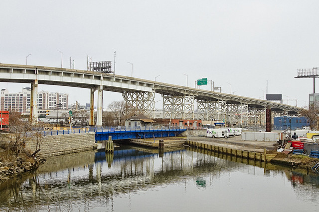
The photo above depicts the most photogenic of NYC’s subway lines – the IRT Flushing, or 7 line – exiting the elevated tracks of the Court Square Station and traveling on its way to Manhattan.

– photo by Mitch Waxman
One spent a bit of time up on the tracks, as I ran into an old friend while making my way up there and we spent some time catching up while I waved the camera around. The cutoff is brutally bare during the winter months, as all of the self seeded vegetation surrounding it is deep in hibernation. During the warmer months, it’s positively verdant up here – an island of green amidst the concrete devastations of Western Queens.

– photo by Mitch Waxman
Disturbingly, the Queens Cobbler seems to have visited the Cutoff recently, leaving behind one of the totemic “single shoes” signaling that he or she was here. The “Queens Cobbler” is the name I’ve assigned to a likely serial killer who claims human lives all around the Newtown Creek watershed, leaving behind a single shoe to announce that their latest hunt has been successful.
Someday, the NYPD will happen upon a hidden warehouse room in LIC or Maspeth filled with footwear and gore, and on that day – the metaphorical and literal “other shoe” will truly fall. Back next week with something completely different at this – your Newtown Pentacle.
“follow” me on Twitter- @newtownpentacle
enjoined to
It’s National Tater Tot Day, in these United States.

– photo by Mitch Waxman
For a maritime city, New York doesn’t actually seem to get foggy all that much. Sure there’s mist and murk occasionally, but it’s actually pretty seldom that we get a full on “inversion” and the sky fills with straight up pea soup. Whenever fog conditions do occur, however, one makes sure that the camera is out and about.
Nothing I like more than some atmospheric diffusion.

– photo by Mitch Waxman
These shots were gathered on the 21st of January, when just such an atmosphere permeated and propagated across the neighborhood. As I’m wont to remind everyone around Newtown Creek – constantly – if you can smell it, you’re breathing it. On this foggy Saturday in January, we were all breathing New York Harbor for a day.
Speaking of Newtown Creek, check out how the new Kosciuszcko Bridge’s cable stay towers are visible from the corner of 39th street and Skillman Avenue in Sunnyside.

– photo by Mitch Waxman
One left HQ relatively late in the day, hoping to catch that particular moment when the burning thermonuclear eye of God itself would angle itself properly to create sculptural lighting for the industrial landscape of LIC. Win!
The shot above looks down 47th avenue, as you travel down off the shallow ridge that Sunnyside and Woodside straddle towards the alluvial flatlands surrounding the Dutch Kills tributary of Newtown Creek, just for the curious.

– photo by Mitch Waxman
As part of my “winter strategy,” which allows for taking some sort of transport in one direction to or from “Point A” in Astoria, a short ride on the “7 line” carried me to Queensboro Plaza where I transferred over to the Astoria bound “N line.” Glad that I did so, as the photo above was my “shot of the day” for the fog occluded 21st of January.
“follow” me on Twitter- @newtownpentacle
modern matters
It’s Street Children’s Day, in the Republic of Austria.
– photo by Mitch Waxman
Dutch Kills, a tributary of Newtown Creek which abruptly turns north off the main channel three quarters of a mile east of the East River, is entirely contained within Long Island City. It’s crossed by five bridges – the LIRR bridges DB Cabin and Cabin M, the Borden Avenue Bridge, the Queens Midtown Expressway truss, and the Hunters Point Avenue Bridge. Dutch Kills, like all of Newtown Creek’s tributaries and the main channel itself, is lined with a toxic sediment referred to as “Black Mayonnaise.” This sediment is composed of coal tar, petroleum and refining byproducts, industrial waste of various provence and typology, as well as human excrement deposited by NYC’s open sewers.
At its northern terminus, Dutch Kills is across the street from a CUNY college and several charter schools serving high school and junior high school aged kids. One of the most significant build outs in recent real estate history is happening less than a quarter mile from that spot, along LIC’s Jackson Avenue in an area referred to as “Court Square.”

– photo by Mitch Waxman
Due to a non functioning railroad swing bridge at Dutch Kill’s junction with Newtown Creek’s main channel, there is absolutely zero maritime industrial activity along the tributary. The bulkheads along its reach generally date back about a century, to a massive “improvement” conducted around the time of the First World War which saw the marshes and swamps it fed drained and both the Sunnyside Yards and the Degnon Industrial Terminal constructed.

– photo by Mitch Waxman
The streets surrounding Dutch Kills offer fleeting glimpses of the waterway, and many of them are not City streets at all but “railroad access roads” owned by the MTA. You can almost always smell the waterway before you can see it, and whereas I can tell you a few spots to access the water, none of these are “legal” and all involve trespass of private or government property. You can legally observe it from the Borden Avenue or Hunters Point Avenue bridges, however.
At it’s terminus – or “turning basin,” there are two abandoned oil barges rusting and rotting away into the water.

– photo by Mitch Waxman
Illegal dumping, the native art form of the Borough of Queens, is practiced hereabouts with relish and abandon. The DSNY garbage bin in the shot above appeared on 29th street back in November, and I’ve been watching it steadily fill up and overflow. DSNY doesn’t seem to remember where they put it, as I haven’t seen it empty since the day it arrived.

– photo by Mitch Waxman
Amidst the sheens of oil and grease you’ll observe on Dutch Kills, which are both historic and newly spawned, there are what the NYC DEP would describe as “floatables.” That’s government code for garbage that’s either been flushed or has been swept into the sewer grates on every street corner in NYC. In the case of Dutch Kills, the “sewer shed” that feeds these floatables into it extends all the way to East Elmhurst and Woodside to the east, Sunnyside and Astoria to the north, and the rapidly growing Long Island City which Dutch Kills is a part of.
The sewer plant that handles this burgeoning area was opened in 1931, and Fiorello LaGuardia cut the ribbon to open it.

– photo by Mitch Waxman
There is going to be a meeting tomorrow, the latest of many, of the Newtown Creek Community Advisory Group (CAG) on the first of February. If the shot above looks good to you, and you’d like to see more of the same – don’t come. If you care about not having a billion and a half gallons of raw sewage a year spilling onto mounds of poisonous and century old industrial waste, do come. Pipe up, we need voices and perspectives from outside the echo chamber.
Details on the meeting – time, place, etc. – can be accessed at this link. We could really use some Queensican bodies and voices in the room.

– photo by Mitch Waxman
As evinced by the corpse pictured above, life has actually begun to recolonize this waterway in recent years. The presence of higher mammals hereabouts speaks to an ecosystem that is beginning to recover from centuries of industrial and municipal abuse. Of course, nothing is going to save a raccoon from getting ground into hamburger by the wheels of a semi truck.
At Newtown Creek Alliance, we’ve been cataloging and observing for a while now. There’s more than seventy individual species of birds for instance – including Great Blue Herons and Ospreys – living along the lugubrious Newtown Creek. Their presence speaks to a growing population of prey animals (fish) present in the water column, and to a broader environmental recovery happening along this industrial waterway at the literal center of NYC.
“follow” me on Twitter- @newtownpentacle
awestruck party
It’s Fred Korematsu Day of Civil Liberties and the Constitution, in the states of California and Virginia.

– photo by Mitch Waxman
Throw your hands in the air, like you just don’t care.
That’s what most of the residents of Queens do when the subject of Newtown Creek comes up. That’s Brooklyn’s problem, not ours. Then I tell them about how the decisions affecting Queens are being made by the “transplant hipsters of Brooklyn” whom they revile, and that whereas Brooklyn is going to be getting new parks and other municipal goodies out of this Superfund thing… Queens is largely being left out of the equation. That riles the north shore peeps up a bit, but they still don’t get involved. Since the people of Queens are disinterested, so is elected officialdom.
Fish, or cut bait. If neither, then get out of the way.

– photo by Mitch Waxman
I’ve always chalked it up to topography. If you’re in East Williamsburg, or Greenpoint, Newtown Creek is part of your life whenever you open your window. The Brooklyn, or south side, of the Newtown Creek hosts residential properties which are literally across the street from the bulkheads. The Queens, or north side, communities generally have a buffer zone of industrial buildings and highways separating them from the water. Newtown Creek is a half mile from residential Sunnyside.
In Queens, they complain about truck traffic, hipsters, and gentrification.

– photo by Mitch Waxman
We are at a critical juncture, Newtown Creek wise. The science from all parties involved in the cleanup is beginning to be compiled. The DEP, in particular, is about to lock itself into a quarter century long program of construction and strategic maneuvering. Around a year or so from now, the oil and gas people will be doing the same and committing to a strategic course.
Ultimately, EPA will be doing the same thing and deciding on their course of action, but given the current political crisis in the Federal Government there is no real day to day guarantee that there will be an Environmental Protection Agency which resembles the current one.
What do clean and accessible waterways mean to President Trump and Steve Bannon?

– photo by Mitch Waxman
There is going to be a meeting, the latest of many, of the Newtown Creek Community Advisory Group (CAG) on the first of February. If the shot above looks good to you, and you’d like to see more of the same – don’t come. If you care about not having a billion and a half gallons of raw sewage a year spilling onto mounds of poisonous and century old industrial waste, do come. Pipe up, we need voices and perspectives from outside the echo chamber.
Details on the meeting – time, place, etc. – can be accessed at this link. We could use some Queensican bodies in the room.

– photo by Mitch Waxman
The shots in today’s post were gathered on the eastern side of the Newtown Creek, in Ridgewood and Maspeth. The environmental conditions in these industrial buffer zones are off the charts bad. You don’t have to look far to find dead birds, rats, all sorts of unlucky critters who innocently wandered in here. It wasn’t the Creek that killed them, it was the hundreds of heavy trucks.
As a note to Maspeth and Ridgewood residents – this is where the trucking you complain about comes from.

– photo by Mitch Waxman
There’s a vision of what the future can hold for generations unborn that we have all been working for and towards. An industrial canal which also welcomes recreational boaters. An industrial canal which was the most significant job creation engine NYC has ever seen and which can be so again. A mixed use waterway in which business and the ecology operate hand in hand.
Ever heard of the “Maspeth heat island effect”? It’s the reason why your energy bills are so high during the summer, and it’s caused by the complete lack of green space in these industrial neighborhoods, which causes temperatures hereabouts to be ten or more degrees warmer during the summer than in surrounding communities. Is that Brooklyn’s problem? What about the trucks, or the garbage trains?

– photo by Mitch Waxman
This post is meant to scold, and compel. Get involved, whatever your point of view is. The political elites of our City will not care unless you care.
“follow” me on Twitter- @newtownpentacle
odd debris
It’s National Chocolate Cake Day, here in these United States.

– photo by Mitch Waxman
Progress. That’s what they used to call it. The reclamation of wetlands for profitable municipal or private use, and the installation of some sort of useful industry upon the new land. Here in Queens – Northern Blvd., or Jackson Avenue depending on where you are standing, used to be a raised road that rolled through a swampy lowland. Queens, and LIC in particular, were remarkable in the post Civil War era for the prevalence of water borne diseases suffered by occupants of the various towns and villages found along its route. Typhus, malaria, cholera – all of the mosquito vector illnesses were quite common.
It’s the reason that Queens was so open to large scale development in the early 20th century when technologies emerged that allowed for the draining of swamplands and marshes. In a sudden burst of activity at the start of the last century – you see the emergence of the Queensboro Bridge, the Sunnyside Yards, and the appearance of the subway system.
– photo by Mitch Waxman
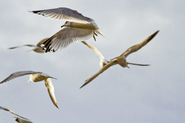
As far as the critters go, they’re still following their old patterns even though the ancestral waters are buried tens of feet below the surface. It’s why you’ll still see clouds of gulls flying around at Sunnyside’s northern border or over in Woodside, miles from the East River or Newtown Creek.

– photo by Mitch Waxman
The automobile represented “progress” to the generations who fought the World Wars. The City was remade and rebuilt by Robert Moses and the armies he led in pursuance of progress. The highways and local streets which divide us also provided the opportunity to raise the level of land over the water table and install sewerage systems. These sewers quicken the flow of water, which in turn did away with the languid puddles and marshes in which the disease spreading clouds of mosquitos could breed.

– photo by Mitch Waxman
There was no more potent symbol of “progress” in the late 19th century however, than the railroad. Unfortunately, it was ruled by opportunist financiers like JP Morgan and predatory capitalists like John D. Rockefeller, both of whom contributed to the industry becoming less and less profitable to operate. Robert Moses was no friend to the railroads either. Ultimately, by the late 1960’s, all of the private rail companies that handled passenger and freight were bankrupt and brought under government control.

– photo by Mitch Waxman
Progress seems to be a forgotten concept in the modern day. It’s about maintaining what we’ve inherited, rather than dreaming big, of what we could have. We no longer reach for the stars, even on National Chocolate Cake Day.
“follow” me on Twitter- @newtownpentacle
