Posts Tagged ‘queens’
less than
Another day, another bridge across Newtown Creek.

– photo by Mitch Waxman
There are five bridges crossing the Dutch Kills tributary of that lugubrious ribbon of urban delight called the Newtown Creek, here in Long Island City. You’ve got two movable railroad bridges, the retractile Borden Avenue Bridge, the high flying truss which carries the Long Island Expressway and then slopes down into the Queens Midtown Tunnel, and the good old Hunters Point Avenue Bridge. There’s been a bridge of one kind or another here since about ten to twenty years after the Civil War, with one notable span made of wood whose opening and closing was powered by ropes and a donkey. The current bridge was installed in 1910, when Michael Degnon was building his industrial terminal around Dutch Kills, and the Pennsylvania Railroad was finishing up their construction of the Sunnyside Yards.The Hunters Point Avenue Bridge was originally a double bascule drawbridge, but back in the 1980’s, the City rebuilt the roadway and replaced the mechanism with a single bascule version, which is the one featured in today’s post.
Apparently, Hurricane Sandy did quite a job in the electrical equipment that operates the thing, and since the City is required by the United States Coast Guard to maintain the HPA Bridge as a movable structure there’s been folks working “down below” in the gears and gizmos of the thing. It’s on one of my main routes when I’m out for a walk.

– photo by Mitch Waxman
The other night, Dutch Kills was frozen into a giant plate of ice. This isn’t surprising, since the hydrology of the canal displays very little in the way of laminar or horizontal flow. The water rises and falls with the tide, obviously, but the shapes and angles of the bulkheads in addition to zero sources of flowing water at its terminus other than a couple of open sewers cause the waters of Dutch Kills to mimic the behaviors of a stagnant lake rather than a flowing creek.
A few years ago, I started reading up on hydrology and talked to some of the powers that be about using “shaped” concrete forms to cause zones of compression and expansion which would passively move the water around a bit, but nothing really came of it. I still think this sort of engineering is the way to go, however. As I understand the concept, rounded shapes act as “brakes” in fluid systems, whereas narrowing the width and obliquing the angle of channel walls causes water to flow (think river rapids). Essentially, large bodies of water can’t rise that much above the level of surrounding water bodies they’re connected to, so when the volume hits a point of compression it gets “squeezed” and pressurized which causes it to begin moving towards a point where it can expand again. As an example, the same water pressure in your kitchen faucet is what feeds into your garden hose, with the only difference between the wildly dissimilar behavior of the same water pressure being that the stuff in the hose has been compressed all the way through the nozzle and the sink faucet flow can just expand into the basin.
Design in enough points of compression and expansion, you’ve got “flow.” Or at least, that’s my theory. What do I know, I’m a schmuck with a camera, not an engineer.

– photo by Mitch Waxman
Another hypothesis I can offer is that the Newtown Creek is far more biologically active at night than it is during the daytime. All the time I’ve spent around the waterway in the last year at night has revealed an otherwise hidden world that comes out in the dark. There’s higher mammals, both feral cats and raccoons, which are occupying the predator and scavenger niches. You can see and hear vast numbers of fish splashing around in the water, and there’s all sorts of critters crashing around at the littoral edges and along the bulkheads.
The shots in today’s post were exposures of about thirty seconds, so you won’t see what I saw when shooting them unless it held stock still for that interval of time. What I saw was a big fat raccoon foraging around at the water’s edge, scooping up shell fish and other horrible wriggly things to eat for dinner. Actually, it was probably for breakfast, as the trash pandas are nocturnal – just like me.
“follow” me on Twitter- @newtownpentacle
gathered here
Mitch Waxman, working for YOU!

– photo by Mitch Waxman
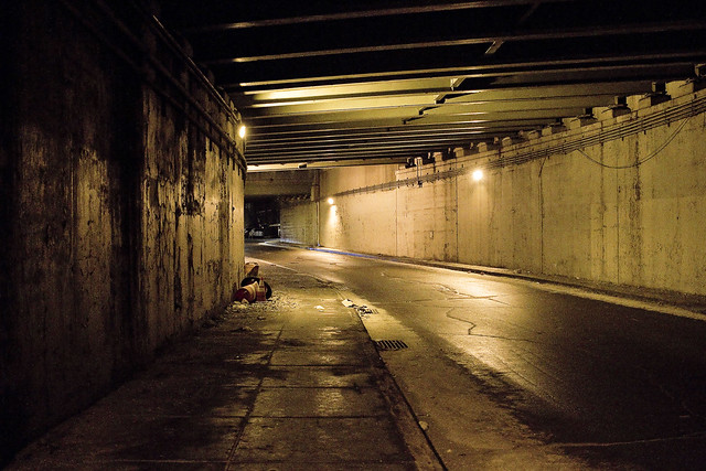
The pathway which will allow access to the bike and pedestrian lane of the new Kosciuszcko Bridge is pictured above, a terrifying “last mile” section which is owned by the City. This is the approach at “Queens Midtown Expressway” or “Borden Avenue” (depending on whose map it is) which you get to via a southward journey along 43rd street in Sunnyside. It’s also the onramp for the BQE, and there’s nothing separating you from traffic other than a three inch curb. If you’re wondering, this is actually a fairly well used foot path between industrial Maspeth and South Sunnyside – so it’s not just me.
Why do I go this particular way? I’ll show you at the end of the post.

– photo by Mitch Waxman
Inviting, ain’t it?
A humble narrator is ringing the alarm bells here for a fairly simple reason, the Kosciuszcko Bridge construction project is meant to be opening the second and final half of the project up to traffic (of all kinds) by the end of the summer, at the latest. The City, which is supposed to have been redesigning this section of things (they own it), hasn’t been shown to have started any risible progress yet. Supposedly NYC DOT has a design, but where is it? Shovels in the ground, boys?
I’d be happy with a bunch of jersey barriers, truth be told.

– photo by Mitch Waxman
For years, literally years, I’ve been keeping an eye on this one.
I cannot tell you how many times in Western Queens that I’ve had the sudden realization that the sidewalk I was scuttling on led onto a highway. One time, after leaving St. Michael’s cemetery, the section of Astoria Blvd. I was walking along suddenly became the shoulder lane of the Grand Central Parkway as the sidewalk just ended.
– photo by Mitch Waxman
This path leads to a pedestrian bridge, one that the K Bridge project has recently constructed as a replacement for a far older but similar lane. Friends who grew up on the southern flank of Sunnyside tell me that this path was well familiar to them growing up, and that the road and sidewalk conditions found in the shot above date back to their earliest recollection.

– photo by Mitch Waxman
Just last week, I was walking through here and spotted the condition above. Hadn’t been through in about a month, so it’s possible this collapsed in sewer grate had been lying in wait for an errant tire to enter it for weeks.
Here’s the “working for you part.”

– photo by Mitch Waxman
First things first, you document it. That’s me and the camera in the shadow on the left. Second, you report it.
Now, here’s the thing… I often have trouble making 311 or 911 operators understand that Queens has hyphenated addresses. Also, it took several paragraphs of text and a few photos to describe the location and condition of this place to you, my quite savvy and well traveled Lords and Ladies of the Pentacle. Additionally, this was a dangerous situation and I feared somebody could be seriously hurt if their tire entered the hole.
Prior experience with road condition and damaged sewer hatch reporting (yep, lots and lots of prior experience) has taught me that it can take weeks for the City to dispatch somebody to do repairs. They’ll send the cops out to throw down a traffic cone, but otherwise – weeks. I’m “Mitch Waxman” however, so a quick scan of the contact list on my phone allowed me to contact the K Bridge team’s Community Liason’s office, who in turn alerted the NYC DEP, whose sewer it is. DEP dispatched an emergency squad within the hour and they had the thing all fixed and repaired by the next morning. On the repair front, I let my pals at Jimmy Van Bramer’s office know about all the goings on and how great I thought it was how the K Bridge team and DEP handled the situation. That was also in the name of “reporting it” since JVB’s office keeps a list of complaints and problems in his District and since this one wouldn’t come to them via 311 or 911, there you are.
Nobody gets hurt. Street boo boo all better now.

– photo by Mitch Waxman
On the other side of the “last mile” path, there is a permanently installed concrete separation between you and the onramp of the BQE. Where it slopes down and ends is the demarcation point of NYC and NYS’s property lines, or so I’m told. Want to guess why they’re there?
Yeah, that was me, suggesting it to the Engineering Team at K Bridge sometime back in 2012 or 2013.

– photo by Mitch Waxman
My pal “Special” Ed once described his ideal job title as “freelance unsolicited criticism,” which would take the form of waking into a bank and decrying the arrangement of the padded ropes leading to the tellers, whereupon he would then hand them a bill for his services. I don’t charge, but I fear that I’m living out Ed’s dream. Ed used to live downstairs from me in an apartment building on Manhattan’s Upper West Side, one which was packed with high school and college friends. We lived a life disturbingly reminiscent of “Seinfeld,” I’m afraid. Ed had nothing in his refrigerator save for a single glass of water and a spoon, and stored his clothing in the kitchen cabinets. I miss Ed.
Pictured above is the K Bridge from that pedestrian ramp dealie which carries you over the onramps to it from the LIE onto Laurel Hill Blvd. at the border of Maspeth and Blissville, and between the Kosciuszcko Bridge and First Calvary Cemetery.

– photo by Mitch Waxman
This is why I go this particular way. The view.
Just imagine what treasures await, when the ped and bike path is open. That’s presuming you don’t get squished by traffic on your way here, and end up in there.
“follow” me on Twitter- @newtownpentacle
spreading crypts
The other way!

– photo by Mitch Waxman
Pictured above is the newly reopened Broadway stop on the Astoria line N/W elevated. I spent all week describing a walk heading northwards along 31st street towards Astoria Blvd., so I decided to do one today describing the walk southwards from Broadway towards Northern Blvd., just in the name of completeness. The station has been rebuilt and reimagined, as one of the new “Enhanced Stations,” by Governor Cuomo, who does and does not run the MTA with an iron fist. It’s the Dark Prince of Albany who decides on when and if he’s in charge, so ask him if today is one of those days.
The enhanced stations bring some amenities to the table like station wifi and new security cameras, and Broadway in particular has seen a new exit only stair way (no fare control) installed which really has been a game changer in terms of expediting exiting of the facility. The big change, most noticeable from the street, has been the amount of new lighting systems installed, which has really altered the “feel” of the corner.

– photo by Mitch Waxman
Most of the 31st street corridor lives in perennial and centuried shadow, and even during the day, it’s dark. The street lamps are generally miniatures, with smaller than normal luminaire heads sitting on midget sized poles directly over the parking lane except at the intersections. There’s no lighting system in the middle of the street, suspended from the trackage, which lends an ominous “noir” to 31st street.
Personally speaking, given my proclivity towards darkness and skillful street camouflage born of living in 1980’s NYC, such lack of ambience holds no terror. Were I a lady or looked like I had money in my pockets, however, I’d likely be clutching my pearls while walking down this street given the lack of street life and darkness.

– photo by Mitch Waxman
The lighting schemes of the new stations spurt ambience all over the place. That’s the 36th avenue stop in the shot above, if you’re curious. It’s one of the “angles between neighborhoods” spots here in Western Queens, with LIC’s Dutch Kills and Ravenswood neighborhoods found to the south and west of 31st street and the “Astoria/Not Astoria” triangular shaped neighborhood between 34th avenue and Northern Blvd. to the east and slightly north. It’s also one of those interesting spots in Queens where you’ve got a soft geographic boundary between two wildly different ethnic populations, mostly Pakistani and extremely religious Muslims to the west and Brazilians to the east. There’s lots of other people mixed in there, of course, but dominant population groupings are what makes a neighborhood distinctive.

– photo by Mitch Waxman
The remnants of “mixed use” industrial zoning can be observed on the dark parts of 31st street as you proceed south, but these buildings and businesses are doomed by the aspirations of the affordable housing crowd and the Real Estate Industrial Complex. It’s already started, there’s more than a few of these old warehouse and factory buildings which have been demolished to make way for cookie cutter glass box residential buildings. In the distance, you can see the high rise residential buildings of Queens Plaza and “next big thing LIC” rising alongside the boundaries of the Sunnyside Yards.

– photo by Mitch Waxman
Nearing 39th avenue, where another of the enhanced stations is nearing completion, and the luminance of said station making a real difference in the “feel” of the street. Across the street from where this shot was taken is a Coptic Christian church and pastorate house which serves a mostly Egyptian community, or so I’m told. A large group of apparnetly Egyptian men were gathered in front of a new Dunkin Donuts on the corner of 39th, drinking take away coffee in paper cups and smoking cigarettes while debating something in their native tongue.
It was growing colder by the minute, and I decided it was time to start winding up my “constitutional” and head back home to Broadway in the 40’s via Northern Blvd.

– photo by Mitch Waxman
Progress? One still wonders about the lack of street life, storefront businesses, and ambient light on 31st street. It’s a traffic thoroughfare ultimately – 31st street – connecting Queens Plaza with the Grand Central Parkway and Triborough Bridge in its 20th century incarnation. There are, in fact, homes and businesses along its route, but personally I wouldn’t want to live along it. One thing I haven’t mentioned, whether in this series of posts or the ones from a couple of weeks ago describing Roosevelt Avenue and the streets of the Flushing Line corridor, is noise. Train noise, specifically.
Famously, I’m always listening to something on my headphones while out on my little jaunts, and when the train is passing overhead the noise overwhelms the speakers which are plugged directly into my ears. Can’t imagine what it’s like living next to those tracks, it must be hellacious.
“follow” me on Twitter- @newtownpentacle
popular opinions
Darkness and cold, it’s all darkness and cold.

– photo by Mitch Waxman
So far this week we’ve established a few things – the physical dimensions of a size 18 EEEEEE male foot, that Astoria’s 31st street used to be call Debevoise Avenue prior to the 20th century, and the convoluted and confusing history of the Astoria line elevated tracks which have defined the street since at least February of 1917 (I have no idea when construction on the “El” began, whether in 1915 or 1916 or whenever) have been explored. My “constitutional” stroll, which is how I refer to a short 90 minute walk “around” the neighborhood, found me turning north on 31st street and heading towards Astoria Blvd. from Broadway.
Along my way, I kept on wondering why it is that for the last century or so seemingly everybody over in Manhattan who has had a bright idea about how to “fix” Queens has been handed de facto Carte Blanche to explore and build their scheme. You don’t find a “Utopia Parkway” in other boroughs.

– photo by Mitch Waxman
From a city planning perspective, Astoria Blvd. can easily be analogized as a “municipal sacrifice zone.” First, however, I have to state my perception of Astoria itself being composed of three distinct neighborhoods. Two of them are divided by Astoria Blvd., with the commercial strips of 30th Avenue and Broadway defining the southern one, and the commercial strip along Ditmars Blvd. defining the northern one. The remaining section is defined by and found west of Crescent Street. Again, that’s my perception, and unfortunately the Real Estate Industrial Complex is constantly trying to redefine the ancient village with names like “Eastoria,” “Westoria” and so on. Sigh.
In 1922, a group of Queens based planners proposed the creation of a “scenic drive” which would start at Astoria’s East River waterfront, travel along Astoria Blvd., and hug the northern shoreline of the borough all the way east to the Nassau County line. Robert Moses liked that idea, and especially so when he began working on the Triborough Bridge. The first nine miles of the Grand Central Parkway, between Kew Gardens and Glen Oaks, opened in 1933. Moses has to find a way to pay for and build what he called “the missing link,” however. The missing link would connect Long Island’s Nassau County to his bridge.

– photo by Mitch Waxman
July 11th of 1936 is the day that the Triborough Bridge opened for traffic. Moses made a deal with the Federal Public Works Administration allowing him to spend $44 million – that they allocated for the approach roads to the bridge complex – to construct the seven and a half mile long “missing link.” The Grand Central was dug into a trench through Astoria, coming back up to the surface at East Elmhurst, where it runs to Flushing on a shoreline extension into Flushing Bay composed of landfill sand (which Moses brought in from his various beach projects in Rockaway). The parkway has been widened and deepened multiple times in the eight decades since, but the blighting divisions in Astoria have remained constant.
Last time I checked, some 180,000 vehicles a day exit and enter the Triborough Bridge complex via the Grand Central Parkway. As a note, the reason it’s called a “parkway” as opposed to a highway or expressway is because the shoulders of the road are planted. Once upon a time, there were apparently pedestrian pathways in those planted shoulders.
“follow” me on Twitter- @newtownpentacle
ritual nature
Walking up 31st street, in today’s post.

– photo by Mitch Waxman
I’ve always wondered about the usage of “up” and “down” when referring to local destinations, since such determinations should logically be circumstance based. Saying that, I know people who say “up on Ditmars” that actually live there and everyone in Astoria refers to Queens Plaza and Long Island City as “down there.” It’s weird. Additionally, you ever notice that most people will say “I HAVE to go into the City” versus “I WANT to go into the City”? Manhattan is the place for “have to” I guess. If you live in Astoria, and you “have to” you either need to go down to Broadway for the R/M subway, or over to 31st street for the N/W elevated.
As mentioned yesterday, 31st street in Astoria used to be Debevoise Avenue prior to the consolidation of the City of Greater New York, during and before the time that Astoria itself was part of an independent municipality called Long Island City which existed from 1870 to 1899. Before 1870, Astoria was officially a “village.” Shortly after NYC consolidation, and the opening of the Queensboro Bridge in 1909, the aforementioned subways started snaking out of Manhattan and off the bridge into Queens, and later on through underground and underwater tunnels. It’s hard to imagine today, but a century ago, Astoria was considered to be a suburb.

– photo by Mitch Waxman
First off, the government did not build or design the entire subway system. This is a really complicated subject, btw, and I’d recommend talking to the actual historical experts at the NYC Transit Museum about it if you’re interested.
NYC underwrote and facilitated a lot of the system, but the subways were built largely by two private companies – the IRT or “Inter Borough Rapid Transit Company” (which had already merged with and devoured the BRT or Brooklyn Rapid Transit Company) and the BMT or “Brooklyn Manahattan Transit Corporation.” There was also an IND or “Independent City-Owned Rapid Transit Railroad,” which was – in fact – a governmental entity. IRT (MTA “A” division) and BMT (MTA “B” division) built lines have different car widths and specifications, meaning that even today – more than a hundred years later – you can’t run one Division’s train set through another’s station due to the width of the cars and platforms. Same sort of thing is true for LIRR and Metro North, believe it or not.
The BMT Astoria line tracks were originally part of the IRT system, just like the Flushing or 7 line. Both use a platform at the Queensboro Bridge, but they split up after that station to work their different routes. The Astoria line opened on the 1st of February in 1917, and its station specifications were built to IRT (Inter Borough Rapid Transit Company) standards. In 1920, the 60th street tunnel opened, which allowed BMT (Brooklyn Manahattan Transit Company) trains to reach Queensboro, where you could transfer to the local bound IRT Astoria line trains. In 1923, BMT had figured out how to run their rolling stock as shuttles through IRT stations on the Flushing Line, but that didn’t last too long. In 1940, both BMT and IRT were bought by NYC from their shareholders and merged with IND into one entity owned outright by the City of New York. About 1949, as far as I’ve been able to figure it, the platforms on the Astoria line were altered to allow the wider BMT train sets to operate along it, and the Flushing line became IRT only. The Astoria line ended up becoming the northern terminus of the BMT’s Brighton/Broadway local service with the equivalent of the modern day N and W lines running up 31st street to the terminal stop at Ditmars Blvd.
Whew!

– photo by Mitch Waxman
As a note, I have assiduously avoided writing about the Dual Contracts era for nearly a decade now. Finally trapped myself into talking about it, so mark your calendars.
One thing which always occurs to me when walking up 31st street is the relative lack of street level retail activity along it. There’s shops and all that sure, but you don’t see the sort of thriving commercial activity which you do along Roosevelt Avenue under the 7 line. I’ve always wondered why.
More tomorrow.
“follow” me on Twitter- @newtownpentacle


