Archive for the ‘Brooklyn’ Category
horrors and marvels
My beloved Creek, in today’s post.

– photo by Mitch Waxman
Pictured above, Newtown Creek.
This is a section I refer to as DUGABO, or Down Under the Greenpoint Avenue Bridge Onramp. On the left side of the shot is the Allocco family’s aggregates recycling yard in Greenpoint, on the right is the SimsMetal recycling facility in Long Island City’s Blissville section. Today’s post will be taking us eastwards from DUGABO into oil country.
Technically speaking – all of the Brooklyn side of the Newtown Creek, from the Pulaski Bridge east to Meeker Avenue was once oil country, home to a series of Standard Oil (SOCONY) refineries and distribution facilities. The industry’s footprint in the area began to shrink as early as the 1950’s, and refining on the Creek literally stopped in the middle 1960’s.

– photo by Mitch Waxman
Literally “DUGABO,” the Greenpoint side on the left shows the tanks of Metro Fuel, a bio fuel company which actually performs some refinery operations in the modern day. On the Queens side, you’ll notice the Tidewater building. Tidewater was a pipeline company that challenged Standard Oil’s monopoly on shipping petroleum using the railroads. Tidewater was destroyed and taken over by Standard. The Standard Oil company then bankrupted the railroads by switching its nationwide distribution system over to pipelines rather than rail cars – despite having spent a couple of decades trying to convince Congress and everyone else that pipelines were inherently unsafe and uneconomical to operate.
You’ve really got to love John D. Rockefeller.

– photo by Mitch Waxman
A bit further east, you’ll notice the tanks of the BP Amoco yard nearby Apollo Street in Greenpoint, which sit on part of the footprint of the Locust Hill refinery.
This is roughly the dead bang center of the Greenpoint Oil Spill, the second largest such event in American History. The BP Amoco yard is a distribution hub, with its product brought in from refineries in New Jersey and beyond by articulated Tug and fuel barge combinations like the Crystal Cutler, which is pictured above. The digester eggs of the Newtown Creek Wastewater Treatment Plant are visible in the shot above as well, as is Manhattan’s iconic Empire State Building.

– photo by Mitch Waxman
A bit further back, that’s Meeker Avenue’s street end on the left or Brooklyn side, and Blissville’s Calvary Cemetery is just out of frame on the right. The former site of Penny Bridge, which looms large in the memory of long time residents of both boroughs, would have been right about the center of the Newtown Creek. Penny Bridge, of course, was replaced in 1939 by Robert Moses. Moses had to work around some pretty big land owners when building it.
On the right hand – or Queens side of the photo – that brick building is part of the former Queens County Oil Works of Standard Oil. The Petroleum facility in Blissville is actually a bit older than Standard, believe it or not. That’s where Abraham Gesner erected the first large scale petroleum refinery in the United States, the North American Kerosene Gas Light company, which imparted to “coal oil” the brand name Kerosene.
When Standard Oil bought Gesner’s operation, the company made the brand name “Kerosene” so ubiquitous that it became an American colloquialism, and it defined the product in the same way that Xerox or Kleenex define photocopies or facial tissue.
“follow” me on Twitter- @newtownpentacle
Upcoming Tours –
September 20th, 2015
Glittering Realms Walking Tour
with Brooklyn Brainery, click here for details and tickets
opprobrious language
Progress on the Kosciuszko Bridge Project, in today’s post.

– photo by Mitch Waxman
Those Open House NY tours from last week? My practice of handing the mike off to other speakers on the return part of the trip so that I can gather a few shots? Yup. Pictured above is the construction site of the NYC DOT and their contractors – principally Skanska – from the turning basin of that fabled cautionary tale of a waterway known simply as the Newtown Creek? Yup.

– photo by Mitch Waxman
The bridge project will eventually run NYS taxpayers around a billion somolians, with the first half of the epic undertaking priced at $550 million. The first phase of the project includes the extensive remodeling of local streets in both Greenpoint and West Maspeth/Sunnyside, the construction of the first (eastern) half of the new bridge, and the demolition of the 1939 Robert Moses model. The second phase will see the erection of the western section of the new bridge, which will be of the cable stay type, and during the entire project – traffic flow of the Brooklyn Queens Expressway has to be maintained.
Framed by the 1939 model in the shot above is Manhattan’s 432 Park Avenue, a residential tower taller than the Empire State Building, whose top floor penthouses have composite valuations close to $300 million bucks. The most desirable of these apartments was recently sold to a Saudi billionaire for an astounding $95 million.
When narrating on the mike, I erroneously said that the penthouses were valued at the same number as phase one of the new Kosciuszko Bridge, but mathematics has never been my strong suit. Also, if I’ve got a hundred bucks in my pocket, I feel rich so there you go. Besides, what’s $200 million to a Saudi Billionaire, anyway?

– photo by Mitch Waxman
On the Brooklyn side of the bridge project, on “used to be Cherry Street,” the support columns for the new bridge are rising steadily. The walking tour which I’ll be conducting on Sunday for Newtown Creek Alliance, which I’ve labeled as “The Poison Cauldron” used to walk right through this area, but given the amount of yuck which the project is kicking up into the air… well… we’re going to get close enough to the project to get a good view of it but not close enough to be in harms way.
The dusk shots in today’s post were gathered during the 5-7 boat tour, btw.

– photo by Mitch Waxman
Also from the Open House NY excursions, this time on the trip that went from 7-9, when post sunset darkness and dramatic lighting from the job site provided for somewhat more dramatic shots of the project. The new bridge will be noticeably lower than the current model, incidentally.

– photo by Mitch Waxman
Progress is moving a bit slower on the Queens side, but is still on schedule. This shot looks north, at the shallow valley formed by Berlin and Laurel Hills that the 1939 bridge was built into. A lost tributary of Newtown Creek was in this area, called Wolfs Creek, which spilled down from the ridge that Sunnyside (or Long Island City Heights as it was once known) was built into.
If you want to come along this weekend and check out the Poison Cauldron, which discusses the oil industry in Brooklyn as well as many other topics of interest along the Newtown Creek, click the link below. It’s a Newtown Creek Alliance tour, and since NCA is a non profit, your tickets will be a tax deductible item and you say that you helped with our efforts to “reveal, restore, and revitalize” Newtown Creek.
“follow” me on Twitter- @newtownpentacle
Upcoming Tours –
September 13th, 2015
Poison Cauldron Walking Tour
with Newtown Creek Alliance, click here for details and tickets
September 20th, 2015
Glittering Realms Walking Tour
with Brooklyn Brainery, click here for details and tickets
gorgeous concealment
My beloved Creek, in today’s post.

– photo by Mitch Waxman
Last Thursday, the Open House New York organization organized two boat tours of Newtown Creek. Back to back, there was one that embarked at 5 and one at 7, and the two tours were sold out. Open House NY asked Newtown Creek Alliance to participate on the tours, and your humble narrator as well as our Project Manager Will Elkins were onboard and on the microphone. Pictured above, the Donjon Towing vessel Brian Nicholas manipulating a series of barges at the City of New York’s Newtown Creek dock, which is occupied by the SimsMetal corporation.
Tom Schadt, who is the Project Manager for the Newtown Creek Group at the Newtown Creek Superfund Site, also participated, and everybody’s friends at the NYC DEP sent along engineer Frank Loncar. Tom Schadt discussed the environmental science his company, Anchor QEA, is conducting for the Superfund “Scoping Period” and Fran Loncar talked about the NCWWTP and DEP’s efforts at ameliorating the effects of the Combined Sewer system that the DEP inherited from the agencies which preceded it (the Bureau of Sewers of Brooklyn and Queens as well as other historical Municpal entities). Will Elkins of Newtown Creek Alliance discussed some of the shoreline restoration and environmental projects NCA has underway.

– photo by Mitch Waxman
As is my habit on boat tours of the Creek, once my section of the narration was accomplished – which is a historical overview and accounting of the various issues affecting the waterway – I handed the mike over to the other speakers and raced down to the bow of the boat to get some photos. The shots in today’s post were gathered at the end of the second tour, which was – quite obviously – well after the burning thermonuclear eye of God itself had ducked behind that western horizon offered by the shield wall of Manhattan.
Pictured above, the aggregates recycling yard of the Allocco family, with the DEP’s Newtown Wastewater Treatment Plant’s digester eggs in the background.

– photo by Mitch Waxman
Further east on the Newtown Creek, that’s Blissville in Queens on the right, and the petroleum district of Greenpoint on the left. The fuel tanks are the BP Amoco yard on Norman Avenue, right around Apollo Street. That’s the former boundary between the Sone and Fleming and Locust Hill refineries of the Standard Oil company and was once the home of the Standard Oil Company of New York – better known to modernity as Mobil Oil.
It’s also the epicenter of the Greenpoint Oil spill, which is actually a completely separate “thing” from the Superfund designation which the rest of the Newtown Creek enjoys.

– photo by Mitch Waxman
Futuristic, the National Grid corporation’s Liquified Natural Gas tanks are found even further east, all the way back at the border of Bushwick near Varick Avenue and Lombardy Street. All of the shots in today’s post were captured while onboard the OHNY boat, and are handheld. Can’t tell you how much I wish it was possible to use a tripod for these kind of shots, but camera support is actually fairly useless when the platform you’re standing on is moving at around five knots. You have no other choice than to open the lens up as far as you can, and jack the ISO up as high as possible, as you still have to use a relatively quick shutter speed to avoid motion blur.
It was exceptionally dark, but that’s Newtown Creek for you.
“follow” me on Twitter- @newtownpentacle
Upcoming Tours –
September 13th, 2015
Poison Cauldron Walking Tour
with Newtown Creek Alliance, click here for details and tickets
September 20th, 2015
Glittering Realms Walking Tour
with Brooklyn Brainery, click here for details and tickets
victoriously swept
If the bridge wasn’t there, it would be impossible to recognize Williamsburg, Brooklyn.

– photo by Mitch Waxman
Mephitic vapors, the effluent of furnaces and forges, a vague scent of molasses, and the smell of freshly smoked crack cocaine used to be all you needed to recognize where you were when visiting Williamsburg. These days, all you’ve got is the visual cue offered by its eponymous bridge and the vague scent of high end Marijuana.
Occasion found me in the ancient village, and as I was headed for Manhattan to meet up with a boat later in the day, a scuttle across the bridge was called for.

– photo by Mitch Waxman
A lot of people think this span is an architectural travesty, but I’ve never thought it was bad enough to to create a Municipal Arts Society over. There are “separate” pedestrian and bicycle paths, which aren’t really segregated from each other in any cohesive manner, but as one such as myself enjoys playing things “by the rules” – I found myself climbing the surprisingly steep ramp leading up from Brooklyn to the bridge itself. At least it provides for some fairly good “cardio.”

– photo by Mitch Waxman
Back in art school, the conventional wisdom imparted to me by a generation of instructors was that you can’t go wrong when there’s an umbrella in your shot. The reasoning is that the umbrella is an inherently interesting shape, and it breaks up the otherwise pedestrian points of view one normally encounters. It wasn’t raining, of course, and the umbrella was simply there to shield its wielder from the particularly powerful emanations of the burning thermonuclear eye of God itself whose gaze seemed fixed upon the bridge.

– photo by Mitch Waxman
All the tourists seem to flock to the Brooklyn Bridge, and its pedestrian path offers one a frustrating and crowded experience. It’s a bit like a lunch line at a buffet, that walk, a slow shuffle while trapped in a queue. Vast preference for the less popular bridges like Queensboro, Williamsburg, and Manhattan is offered by your humble narrator. Crowds suck.

– photo by Mitch Waxman
For this walk, I used my “crappy lens” – a 70-300 consumer level zoom. After the great camera disaster of July, wherein both camera body and my “best lens” were destroyed, I’ve been making it a point of mixing things up a bit. Thanks to many of you who donated money for replacement equipment to this blog, and both body and “best lens” have been replaced. Regardless, one tries to keep things fresh and the extra reach which the imperfect but serviceable “long lens” provides for slightly different perspectives and color rendition.

– photo by Mitch Waxman
It would be utterly pedantic to go into the technical details on this subject, so suffice to say that each and every lens interprets the light moving through it in different ways. Certain lenses are great for portraits, others for landscapes. Camera settings can also affect color rendition as well – for instance, narrow apertures render the color blue in a certain way due to the clipping of upper and lower limits found in the blue light wave.
As I said, technical and pedantic.

– photo by Mitch Waxman
Manhattan side of the Williamsburg Bridge, at Delancey Street, and looking back towards the infinity of Brooklyn.
The Williamsburg Bridge is 7,308 feet long (measuring between the cable anchor terminals) and the deck is some 118 feet wide. The height at the center of the bridge is 135 feet and each tower is 310 feet in height as measured from the East River’s high-water mark. It was originally called East River Bridge #3 when opened in 1903. Its architect was Henry Hornbostel, and the chief engineer who oversaw its construction was Leffert L. Buck.
“follow” me on Twitter- @newtownpentacle
Upcoming Tours –
September 3rd, 2015
Newtown Creek Boat Tour
with Open House NY, click here for details and tickets.
vast and vague
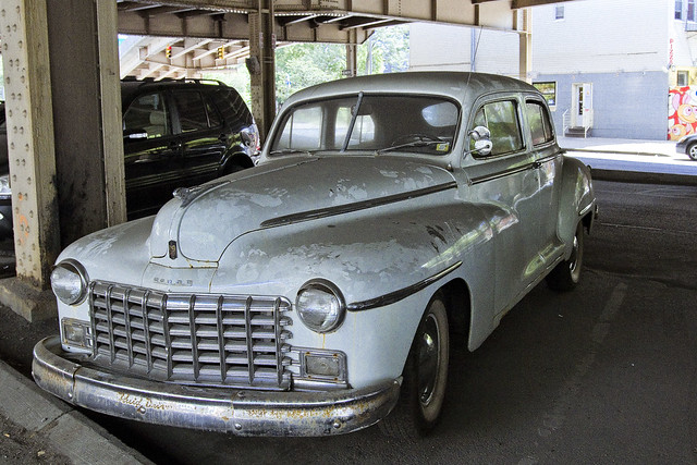
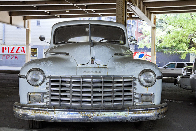
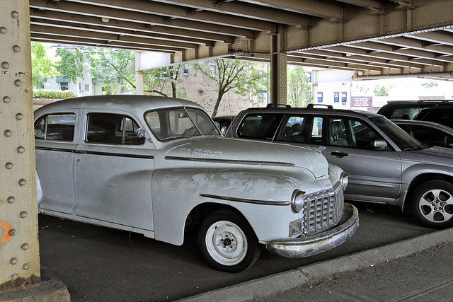
Cool Cars in Greenpoint (?), in today’s post.
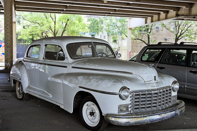
– photo by Mitch Waxman
That long walk under the Brooklyn Queens Expressway in Greenpoint and Williamsburg mentioned at the beginning of this week provided one with several interesting diversions, and notably this undeniably “Cool Car” was one of them.
I’m of the opinion that this Dodge 4 door coupe was likely a 1948 model, an educated guess based on the shape of the windows, fenders, and bumpers – but it is definitely a product of the 1946-1949 era and the very definition of what I like to refer to as “cool cars.”
– photo by Mitch Waxman
There were no tags or registration information adorning the auto, which makes it kind of a difficult endeavor to identify, and given the relative homogeneity of post World War 2 automobile manufacture (Detroit was still gearing down from the war, and the explosion of creativity which auto manufacturers displayed in the 1950’s was not in effect in the years directly following the war).
from wikipedia
Civilian production at Dodge was restarted by late 1945, in time for the 1946 model year. The “seller’s market” of the early postwar years, brought on by the lack of any new cars throughout the war, meant that every automaker found it easy to sell vehicles regardless of any drawbacks they might have. Like almost every other automaker, Dodge sold lightly facelifted revisions of its 1942 design through the 1948 season. As before, these were a single series of six-cylinder models with two trim levels (basic Deluxe or plusher Custom).
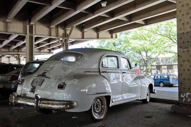
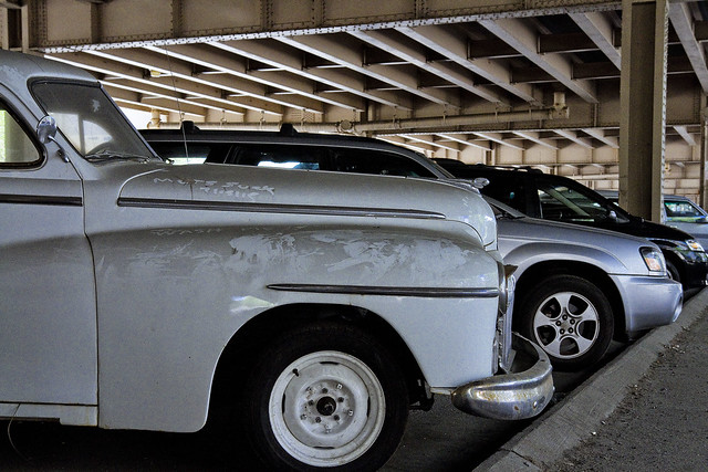
– photo by Mitch Waxman
Your humble narrator is far from an expert on vintage automobiles, it should be mentioned, so if anybody who is reading this is possessed on knowledge on the subject – or recognizes the specific model – please share your smarts with the rest of us in the comments section found below.
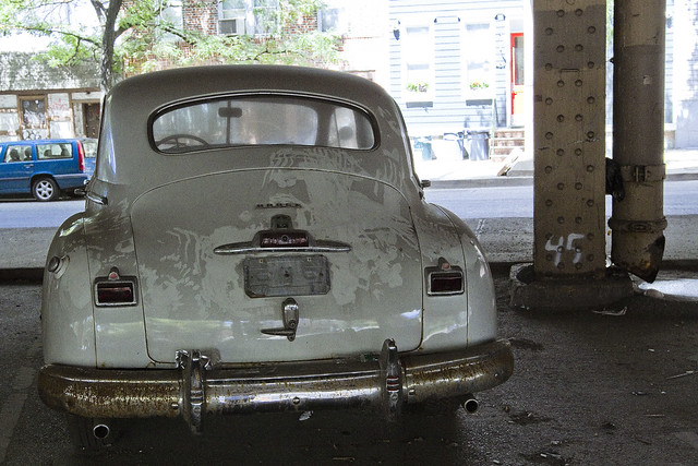
– photo by Mitch Waxman
The location at which this artifact of America’s golden age was found spawns several semantic points as well for the infrastructure nerd. This auto was parked south of McGuinness Blvd. along the west side of Meeker Avenue, under the BQE. Technically, the east side of Meeker is in Bushwick (according to the old ward maps of the pre conolidation City of Brooklyn) and the area to the south of McGuinness is in WIlliamsburg not Greenpoint.
Life long Greenpernters will tell you that their neighborhood actually continues for several blocks east and that the nebulous border Greenpoint shares with Williamsburg is around Withers Street and south of Manhattan Avenue, however.
– photo by Mitch Waxman
Ultimately, this atavistic automobile seemed to be in decent condition, at least externally. It obviously has been parked in this spot for a while given the amount of soot and dust which adorns it. Being Brooklyn, someone felt obliged to trace out “wash me” in the soot – natch.
– photo by Mitch Waxman
It’s a funny thing for me, of course, seeing a 1940’s Dodge parked here in the “House of Moses,” where it fits in with the esthetics of Robert Moses’s early career.
Robert Moses was the master builder of much of NYC’s infrastructure, and personally responsible for creating both the Brooklyn Queens Expressway and the Kosciuszko Bridge. It was his Triborough staffers that mapped out the vast swath that the BQE moves through and was built – condemning and demolishing mile after mile of homes, businesses, and stores to make way for the automobile. Moses plunged Meeker Avenue into centuried and unending darkness when the BQE was constructed, and callously created the divisions between neighborhoods that we all know today. He sort of invented “urban blight.”
– photo by Mitch Waxman
Manufactured items from the middle of the 20th century like this Dodge Coupe are notoriously rare, and extremely attractive to hot rod enthusiasts. A restored or modified iteration of this vehicle would be an extremely valuable commodity. Back then, they really knew how to “build ’em” – both highways and the cars which populate them.
“follow” me on Twitter- @newtownpentacle
Upcoming Tours –
August 22nd, 2015
First Calvary Cemetery – LIC, Queens Walking Tour
click here for details and tickets.
September 3rd, 2015
Newtown Creek Boat Tour
with Open House NY, click here for details and tickets.


