Archive for the ‘Kill Van Kull’ Category
garret studio

– photo by Mitch Waxman
There’s a whole lot of dredging going on.
It seems that the Harbor of NY itself is desirous of silting up, which would destroy its value as a commercial port. What the Harbor is actually doing is attempting to revert to the shallow estuary it once was, following the methodologies set down by nature, but this would impede navigation and be catastrophic for both the economic and urban activities of man.
When the terrorist is nature incarnate- the Marines, Army, or Air Force can’t help you at all. Forget about Homeland Security, for any problem that involves a whole lot of dredging you send in the United States Army Corps of Engineers!
from nan.usace.army.mil
New York Harbor encompasses approximately two-dozen separately authorized and maintained Federal navigation channels. These projects, whose authorized depths vary from 8 feet to 50 feet, along with the privately operated berthing areas, generate approximately 1 to 2 million cubic yards of sedimentary material annually from maintenance dredging alone. Further, several of these channels are either under construction or in plans for deepening in the upcoming years to accommodate larger vessels calling at the port. The construction of these deeper channels will also generate substantial amounts of dredged material. The DMMP process seeks to identify and implement options to manage the material generated from both the federal and non-federal maintenance and deepening of the Port through the year 2065.

– photo by Mitch Waxman
The USACE has over the course of time reshaped the course of mighty rivers, eradicated tall mountains, and they’ve even bent the Helegaat to its will. The USACE has powers and abilities far beyond those of ordinary men, which they employ in a neverending battle for the American Way. In the case of the modern dredging observed around the Kill Van Kull and Port Newark, the Corps are ensuring that the soft bottom of the waterway will be deep enough to allow an enormous class of cargo ship called “Panamax” to safely navigate the port.
This involves the movement and dispersal of a whole lot of dredging spoils.
from nytimes.com
For more than a decade, workers using giant digging machines have scooped up enormous mounds of rock, clay, sand and silt from the waters around New York to deepen the shipping channels to accommodate giant cargo vessels that will navigate the widened Panama Canal starting in the middle of the decade.
The dredging has produced millions of cubic yards of muck.

– photo by Mitch Waxman
There’s a few different machines which are involved in this sort of thing, and not just the claw bucket derricks which are filling barges in these shots. Lots of private contractors actually do the work, with a few key players getting the lion’s share.
Some effort has been made to find shots of these various devices- photos which a humble narrator clearly remembers shooting- but they are currently lost amongst the nearly 20,000 shots which I’ve obtained and uploaded for usage at Newtown Pentacle in the last few years.
As far as my hard drives go, there’s a whole lot of dredging that needs to be done.
from epa.gov
The Administrator of the EPA and the Secretaries of the Army and of Transportation agreed to close the Mud Dump Site for disposal of dredged material in their 1996 Three Party Letter. This was in response to surveys that had shown that contaminants in the dredged material caused sediment toxicity and bioaccumulation effects in estuarine organisms. For example, worm tissue at the disposal site was found to accumulate dioxins, and both dioxin and polychlorinated biphenyl (PCB) contamination was found in lobsters. Individual elements of the aforementioned data do not prove that sediments within the HARS are imminent hazards to the New York Bight Apex ecosystem, living resources or human health. However, the collective evidence presents cause for concern, and justifies the finding that a need for remediation exists, that the site is Impact Category I (see, 40 CFR 228.10), and that the site should be managed to reduce impacts to acceptable levels.

– photo by Mitch Waxman
There’s little controversy around the idea that the government needs to keep these channels open, and lots of acrimony about what to do with the often toxic materials which are brought up to the surface. According to most sources, the sediment which rests on the floor of the harbor contains a cocktail of industrial leave behinds. Concerns are also voiced about sediments which reenters the water column and proceeds to swirl and shoal in new places.
Which brings us back to “What do you do with a whole lot of dredging spoils?”.
from nan.usace.army.mil
To accommodate the increasing need for the disposal of the assorted material, The Office of Supervisor of New York Harbor was established by an act of Congress in 1888. The Harbor Supervisor, acting through the Office of the Chief of Engineers (of the U.S. Army Corps of Engineers), was responsible for the designation of specific disposal sites and for ensuring that ocean disposal would not be detrimental to navigation or pollute adjacent beaches (Williams and Duane, 1974).
Materials including garbage, city refuse, cellar dirt (natural rock and soil excavated during building construction), floatable materials, and sediments derived from dredging during the maintenance, deepening and construction of new channels in New York Harbor, were dumped at specific locations in the New York Bight Apex. Records indicate that approximately six locations were selected to receive this wide range of materials. As the material accumulated at these locations, the sites were relocated farther seaward where increased water depths alleviated concerns of potential navigation threats posed by accumulation of materials.
Hydrographic data spanning the period from 1845 to 1934 revealed that mounds of material were being formed in the general area of the submerged Hudson Shelf Valley (Christiaensen Basin), the Ambrose Light Station (Diamond Hill), and the Scotland Light Buoy. By 1914, shoaling at one of the sites reserved for dredged material and cellar dirt became a critical factor in the decision of the Supervisor of New York Harbor to separate the site usages and thus segregate the material being disposed at each site.

– photo by Mitch Waxman
Were there just some seemingly limitless abyss, an infinity of dark and cold which might just swallow up the sins of the world. Indigo, this ideal dump would boast colossal pressure and unimaginable cold whose combination might vouchsafe whatever poisons you might secret away against future discovery. Some sunken Grand Canyon, which might be neither too far, nor too close.
This would be a great place, a historic one, to dispose of a whole lot of dredging spoils.
from wikipedia
The Hudson Canyon is a submarine canyon that begins from the shallow outlet of the estuary at the mouth of the Hudson River. It extends out over 400 nmi (740 km) seaward across the continental shelf finally connecting to the deep ocean basin at a depth of 3 to 4 km below sea level. It begins as a natural channel of several kilometers width, starting as a 20-40 m depression at Hudson Channel southward from Ambrose Light, then carving through a deep notch of about 1 km depth in the shelf break, and running down the continental rise. Tidally associated flows of about 30 cm/s (1 km/h) up and down the deeper parts of the canyon have been recorded. As silt, sand and mud are carried down the Hudson River, they flow into the canyon and out into the deep sea.
The Hudson Canyon proper is located about 100 miles (160 km) east of the mouth of the Hudson River off the New Jersey coast. Its walls rise three-quarters of a mile from the canyon floor making it comparable to the Grand Canyon, whose cliffs are over a mile deep and 270 miles (430 km) long. It is the largest known ocean canyon off the East Coast of the United States, and one of the largest submarine canyons in the world. The canyon is located near the 100 meter isobath on the continental shelf and is 2,200 m (7,217 ft) deep at the base of the continental slope. Over an 80 km (50 mi) distance, the average slope of the canyon floor is 1.5°. At this point the canyon is as much as 12 km (7.5 mi) wide (from east rim to west rim) and as much as 1,100 m (3,609 ft) deep from canyon rim to canyon floor across the continental slope. The floor of the canyon is less than 0.5 km (1,640 ft) wide across the upper part of the slope and broadens to about 0.9 km (~3,000 feet) at the base of the slope.

– photo by Mitch Waxman
The deeps have been explored a bit, but not enough, by the federal agency NOAA. They report that the canyon is littered with sunken sailing ships, indian canoes, even ocean going diesel freighters of relatively recent vintage. Can you imagine, all there is, that might be down there?
from pubs.usgs.gov
The 150-km-long Hudson Shelf Valley, the largest physiographic feature on the mid-Atlantic continental shelf, bisects the New York Bight region. The Valley is the submerged seaward extension of the ancestral Hudson River drainage system that, unlike other valleys on the Atlantic shelf, has not been filled with sediment. A survey of the topography and backscatter intensity of the valley has been carried out using a Simrad Subsea EM 1000 multibeam sea floor mapping system. The valley head is located in a broad shallow basin and extends offshore 5-40 m below the shelf surface to a seaward terminus at a shelf-edge delta. The valley can be divided into upper, middle, lower and outer sections based on the topography, surficial sediments, and drainage pattern. The middle valley is characterized by 5 local topographic lows along the valley axis that have relief of 3-11 m below the valley floor. The northwestern portion of the study area has been affected by disposal of dredged and other materials since the late 1800’s. Part of this area has been designated as the Historic Area Remediation Site (HARS). The sea floor of the HARS is being remediated by placing at least a one-meter cap of clean dredged material on top of the existing surface sediments that exhibit varying degrees of degradation. A large field of sand waves is located in the lower valley in 70-80 m water depth that cover an area approximately 30 km long and 4 km wide. This sand wave field is hypothesized to be part of a flood deposit that formed as a result of the break-out of glacial lakes in upstate New York approximately 13,500 years BP. In the eastern-most part of the survey area in water depths greater than about 110 m, the sea floor is marked by long narrow northeast-southwest-trending grooves that are interpreted to be iceberg scour marks.
ALSO:
March 5th, as in Monday night:
Riverkeeper and NCA ask: How’s the Water? How’s Newtown Creek?
Join Riverkeeper and the Newtown Creek Alliance for a presentation on water quality in the Hudson River Estuary and its tributaries, focusing on the waters around Manhattan Island and in Brooklyn’s Gowanus Canal and Newtown Creek.
March 5, 2012, 7:30PM to 9:30PM
Brooklyn Brewery, 79 North 11th Street, NY map
and March 6th, as in Tuesday

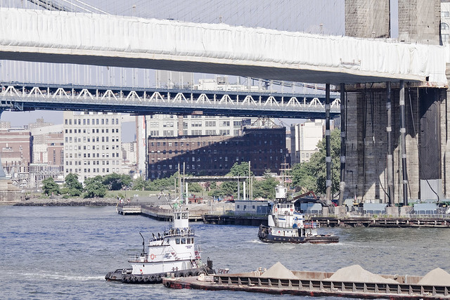
average specimens

– photo by Mitch Waxman
Captain Zeke is an 88 ton tug owned and operated by the White Near Coastal Towing Corp. of Syosset, and was built as the Lady Ora for Falgout Marine at Houma Shipbuilding in Louisiana back in 1980. Unfortunately, neither the company nor the tug have much information available about them, so there’s little more that can be said beyond its size- which is 30 m x 8 m, and its maximum recorded speed of 6.4 knots versus its average of 5.5 knots.
– photo by Mitch Waxman
Captain Zeke ran into a bit of trouble just a few years ago, on the Hudson River.
Spontaneous combustion involving paint rags in a fidley opening may have been the origin of the Aug. 31, 2008, fire aboard the Capt. Zeke, a Coast Guard investigator said. When their fire extinguishers proved inadequate, the tug crew fled to one of the barges.

– photo by Mitch Waxman
Speaking from a position of strictly deductive reasoning at this point, due to a lack of available information about this tug and its owners- Captain Zeke has been personally observed about the harbor moving small loads of a decidedly non volatile nature, as in the previous shot wherein the cargo seems to be sand.
It would be logical to assume that this role is well suited to the relatively small tug, which can most likely get into narrower spaces than the mated tug and barge gargantua which are employed by large players like Reinauer, Moran, or K-Sea (whose vessels specialize in the handling of volatiles) for the transport of various fuels and the handling of cargo vessels.
This theory is contradicted though, by this posting at the blog tuglife, which shows Captain Zeke tethered “on the hip” to a fuel barge.

– photo by Mitch Waxman
In the shots above and below, which were captured on the Kill Van Kull, Captain Zeke is tied to the sort of barge one regularly observes at Newtown Creek handling the SimsMetal trade in bulk metal. It is damnably odd, in the opinion of this humble narrator, that so little information is available online about this vessel. Normally, commercial maritime activity is copiously documented by a variety of private and government entities.
Regardless of this information vacuum, Newtown Pentacle’s “Maritime Sunday” nevertheless recognizes and sends a hearty greeting to Captain Zeke and its crew.
loose and displaced

– photo by Mitch Waxman
Recent activities had carried your humble narrator to… Staten Island… A friend’s photography was included in a gallery exhibit at the venerable Snug Harbor, and wishing to both show support for another photographer and to witness his work in print form- I began the long journey from Astoria in Queens to the outermost of boroughs. After exiting the ferry, I was titillated by the sudden appearance of the gargantuan “Hanjin Lisbon” being guided toward the Kill Van Kull by two Moran tugs.
from marinetraffic.com
- Hanjin Lisbon Vessel’s Details
- Ship Type: Cargo
- Year Built: 2003
- Length x Breadth: 278 m X 40 m
- DeadWeight: 67979 t
- Speed recorded (Max / Average): 21 / 20.6 knots (20.6 knots = 23.7060566 mph)

– photo by Mitch Waxman
Like all the ocean going vessels of its type, the Lisbon is a lumbering monster of a ship. Nearly 1,000 feet in length, the cargo ship was most likely headed to the Port facilities at Newark Bay, and requires the use of tender boats to navigate the relatively narrow and hazard fraught coastal leg of its journey to New York harbor from some impossibly foreign port. It’s titan engines and onboard electronics can propel the ship through open ocean with great accuracy, of course, but the giant cargo ship can’t exactly “stop on a dime”.
from marinetraffic.com
MARION MORAN Vessel’s Details
- Ship Type: Tug
- Year Built: 1982
- Length x Breadth: 39 m X 12 m
- DeadWeight: 10 t
- Speed recorded (Max / Average): 14.5 / 8.9 knots
- Flag: USA [US]
- Call Sign: WRS2924
- IMO: 8121812, MMSI: 366941020

– photo by Mitch Waxman
Tugboat and towing services of the modern era, like Moran towing, are inheritors of centuried wisdom passed down from generations of mariners. The complex currents, mores, and eddies of the harbor are well known to the crews of these vessels and their job includes guiding such massive visitors to the port into safe harborage. Two tugs were observed at work, the Marion Moran and the Gramma Lee T. Moran.
Moran Towing began operations in 1860 when founder Michael Moran opened a towing brokerage, Moran Towing and Transportation Company, in New York Harbor. In 1863, the company was transformed from a brokerage into an owner-operator of tugboats when it purchased a one-half interest in the tugboat Ida Miller for $2,700. Over time Moran acquires a fleet of tugboats. It was Michael Moran who painted the first white “M” on a Moran tugboat stack, in 1880.

– photo by Mitch Waxman
Iconic, Moran tugs are distinguished their large white “M” logo and the white and maroon “color way” which allows them to be identified at great distances across the harbor. Like all tugs, they are built with highly reinforced steel superstructures and powerful engines that allow them to pursue an occupation which requires the ability to precisely handle tonnages which are clumsy and thousands of times their own weight.
from morantug.com
The LEE T. MORAN is an expression of brute power and utility that belies the refinements of technical engineering below her waterline. There, twin ports are cut into the steel hull to make room for the tug’s Z-drive units. On the floor of the shop they look like the lower units of giant outboard engines. Made by Ulstein, a subsidiary of Rolls-Royce, the Z-drive functions much like an outboard. Imagine two outboards extending straight down through the hull, each having the ability to rotate 360 degrees. That makes even a heavy, 92-foot tug with a 450-ton displacement very maneuverable. “It can turn on a dime,” says Doughty. “The hull bottom is slightly flatter to adjust to the two drive units. By turning each drive out 90 degrees, the captain can go from full-ahead (14 knots) to a dead stop in no time.”

– photo by Mitch Waxman
Containerized shipping is what makes the modern world tick, of course, and has enabled the business model of “just in time delivery” to take hold. The steel boxes which adorn the Lisbon’s decks will be unloaded by Gantry Crane at the dock and will find their way onto either rail or truck for delivery to the final consignee. What isn’t commonly known about these cargo ships is that ordinary people can book passage onboard, finding accommodation in a variety of staterooms, and cruise the world on a proverbial “slow boat to china”.
from hanjin.com
Hanjin Shipping (http://www.hanjin.com President& CEO Young Min Kim) is Korea’s largest and one of the world’s top ten container carriers that operates some 60 liner and tramper services around the globe transporting over 100 million tons of cargo annually. Its fleet consists of some 200 containerships, bulk and LNG carriers.

– photo by Mitch Waxman
The mind reels at such suggestions, and your humble narrator is both titillated at the notion of meeting and interacting with the sailors onboard (undoubtedly Koreans, Tagalog, and Chinese- citizens from all over the manufacturing hubs of the Pacific) and terrified by the lore and knowledge they must carry with them about the true nature of the world. Often these cargo ships will encounter pirates, terrorists, and other malingering forces on both the open sea and in coastal waters. Perhaps they have other experiences, of the sort which sailors do not discuss with outsiders, which only a hip pocket flask of raw whiskey might pry out of them.
from wikipedia
The Port Authority of New York and New Jersey was formed in 1921 and the Newark Bay Channels were authorized by the Rivers and Harbors Acts in 1922. Shipping operations languished after the war, and in 1927, the City of Newark started construction of Newark Airport (now known as Newark Liberty International Airport) on the northwest quadrant of the wetlands which lay between Port Newark and the edge of the developed city. Port Authority took over the operations of Port Newark and Newark Airport in 1948 and began modernizing and expanding both facilities southward. In 1958, the Port Authority dredged another shipping channel which straightened the course of Bound Brook, the tidal inlet forming the boundary between Newark and Elizabeth. Dredged materials was used to create new upland south of the new Elizabeth Channel, where the Port Authority constructed the Elizabeth Marine Terminal. The first shipping facility to open upon the Elizabeth Channel was the new 90-acre (36 ha) Sea-Land Container Terminal, which was the prototype for virtually every other container terminal constructed thereafter.
The building of the port facility antiquated most of the traditional waterfront port facilities in New York Harbor, leading to a steep decline in such areas as Manhattan, Hoboken, and Brooklyn. The automated nature of the facility requires far fewer workers and does not require the opening of containers before onward shipping.
escaping forever

– photo by Mitch Waxman
There is just so much to do.
This weekend, as in Saturday the 13th, Forgotten-NY strides confidently into Long Island City for a walking tour of Hunters Point. The inestimable local historian Richard Melnick will be assisting the titan intellect called Kevin Walsh with narration and sartorial anecdote, and I will be scuttling around the crowd. Additionally, I did the photography which will appear in the complimentary tour booklet.
Address your clicking to this link for more information from forgotten-NY on the Hunters Point walking tour.

– photo by Mitch Waxman
Last weekend, your humble narrator was onboard when Riverkeeper conveyed a nervous group of interested civilian observers into the languishing mists of the occluded Newtown Creek. Opportunities to explore the Creek like this are rare, even for those of working for the Newtown Creek Alliance (which is how I ended up on the boat), and hazardous to both physical and mental health. We explored several of the more malign tributaries of the great urban waterway in a small rowboat outfitted with an outboard motor, and experienced things that left all shaken.
Several hundred photos of the expedition will be made public and available for sorting and inspection within the next few days, and they will exhibit a level of environmental ruination -perhaps too terrible to live with- for those who would dare to look. Certain knowledge cannot be unlearned, after all, and for many- ignorance is preferable to living with such facts.

– photo by Mitch Waxman
Additionally, efforts on behalf of the Working Harbor Committee continue as we ramp up to the Great North River Tugboat Race. Of course this event will be happening while the WHC “Hidden Harbor” schedule is underway.
The Hidden Harbor ticketed tours:
- Brooklyn: Detailed narration on and about the historic shoreline from Newtown Creek to the Gowanus Canal.
- Newark Bay: explore the industrial corridor of the harbor along the Kill Van Kull (aka “Tugboat Alley”) and witness Port Elizabeth Newark.
- North River: the Hudson, it’s former industrial might and bright future.
- Specialty tours like my own “Newtown Creek” tour, and the “Light Houses” tour.
- Other private events designed for the benefit of both students and Seniors.
The great North River Tugboat Race will be held on September 4th, and there are limited seats available on the Circle Line observer boat which will be pacing the action as best as it can manage. On Pier 84 (foot of west 44th street in Manhattan at the Hudson River) there will also be free events and fun, including a rope throwing contest, best sailor Tattoo, and a Spinach eating contest.
tentacled starers

– photo by Mitch Waxman
The courthouse in Staten Island, found in St. George near the Borough Hall, has always filled me with some nameless dread- an unknowable and substantive certainty that behind it’s gabled window sashes, there exists a brain blasting horror and existential truth which would shatter my sanity were the curtains to shift and reveal what lurks within.
Since childhood, when school trips or camp outings would bring me to this jutting littoral outcrop from my homeland of infinite Brooklyn, I’ve always maintained that there is just something wrong about the place.
If you think about it, the decline of New York City as an industrial and cultural leader began when the Verrazano Narrows Bridge was completed.
from nyc.gov
Borough Hall was designed by Carrere & Hastings, one of the most influential firms in this country in the early twentieth century. John Carrere (1858-1911) and Thomas Hastings (1860-1929) both attended the Ecole des Beaux Arts in Paris and worked at the firm of McKim, Mead & White. They started their firm in 1885. Carrere, a resident of Staten Island, helped select the dramatic hilltop site of Borough Hall, and was involved with the plan and development of the Civic Center. The firm designed the Richmond County Courthouse next door, the Ferry Terminal (burned) and the St. George Branch Library.

– photo by Mitch Waxman
It must be admitted that …Staten Island… is actually quite lovely in spots and that the prejudice I bear the place is entirely between my own ears. Another perfectly lovely community in the United States- Boulder, Colorado- also receives an unreasoning enmity from your humble narrator. No reasonable explanation can be offered except that both make me itchy and uncomfortable, representative of a way of life unattractive to my personality and tastes. Funny thing is, half of my old neighborhood from Brooklyn moved out here, including my own parents.
If you’re from …Staten Island… and reading this, just chalk it up to inter borough antagonism, and allow me to just rattle on…
from wikipedia
McKim, Mead & White was a prominent American architectural firm at the turn of the twentieth century. The firm’s founding partners were Charles Follen McKim (1847–1909), William Rutherford Mead (1846–1928) and Stanford White (1853–1906). The firm was a major training ground for many other prominent architects -partners, associates, designers and draftsmen.
McKim and Mead joined forces in 1872 and were joined in 1879 by White who, like McKim, had worked for architect Henry Hobson Richardson. Their work applied the principles of Beaux-Arts architecture, the adoption of the classical Greek and Roman stylistic vocabulary as filtered through the Parisian Ecole des Beaux-Arts, and the related City Beautiful movement after 1893 or so, which aimed to clean up the visual confusion of American cities and imbue them with a sense of order and noble formality.
Mead was the last of the firm’s founding partners to die in 1928, after McKim (1909), and White (1906). The firm retained its name after the death of Mead, until partner James Kellum Smith’s death in 1961. The firm – primarily Smith – designed the prominent National Museum of American History in Washington DC, one of the firm’s last works, opening in 1964. McKim, Mead & White was also involved with an urban renewal project at Pratt Institute in Brooklyn in the 1950s and designed three buildings as part of the project: DeKalb Hall, ISC Building and North Hall.
In 1961, McKim, Mead & White was succeeded by the firm Steinman, Cain, and White, which by 1971 had become Walker O. Cain and Associates.

– photo by Mitch Waxman
Perhaps it’s just a psychic charge which the place has carried since the maritime days, when old sailors who had capsized into Snug Harbor would dialogue with the locals in area taverns, exchanging wild stories of the south seas for a shot of whiskey or a glass of beer. Squid like monstrosities worshipped like heathen gods, or a 50 foot shark which bit the prow from a boat, Fijian mermaids, and even stranger reports entered the folkloric gene pool here and mixed in with the hybrid pestilence of both English and Dutch superstitions. Isolation too, held special horrors for …Staten Island…
from wikipedia
Stanford White (November 9, 1853 – June 25, 1906) was an American architect and partner in the architectural firm of McKim, Mead & White, the frontrunner among Beaux-Arts firms. He designed a long series of houses for the rich and the very rich, and various public, institutional, and religious buildings, some of which can be found to this day in places like Sea Gate, Brooklyn. His design principles embodied the “American Renaissance”.
In 1906, White was murdered by millionaire Harry Kendall Thaw over White’s affair with Thaw’s wife, actress Evelyn Nesbit, leading to a trial which was dubbed at the time “The Trial of the Century”

– photo by Mitch Waxman
Rumors abound as to the mission of a certain Catholic Lay organization, based in a dormitory skyscraper on 34th street and Madison in Manhattan- and why certain members of that group (who believe even the Knights of Loyola to have lost their way) seem to spend quite so much of their time on …Staten Island…
One theory which has gained my attention suggests that the Masonic Treasures of Garibaldi still lie extant and occluded in the vast acreage of the place, and that the Holy See wishes to see these relics returned to Roman hands. However, one cannot trust in conspiracy, although… Garibaldi did conspire to overthrow the papal states here, and later succeeded in doing so… But that doesn’t prove anything!
from wikipedia
Thaw was born on February 12, 1871 to Pittsburgh coal and railroad baron William Thaw. Violent and paranoid from a very young age (his mother claimed his problems had started in the womb), he spent his childhood bouncing from private school to private school in Pittsburgh, never doing well and described by teachers as unintelligent and a troublemaker. Still, as the son of William Thaw, he was granted admission to the University of Pittsburgh, where he was to study law, though he apparently did little studying. After a few years he used his name and social status to transfer to Harvard University.
Thaw later bragged that he had studied poker at Harvard. He also went on long drinking binges, attended cockfights, and spent much of his time romancing young women. He was expelled after being picked up for chasing a cab driver through the streets of Cambridge with a shotgun, though he claimed it was unloaded.
Thaw has been credited with the invention of the speedball, an injected combination of morphine and/or heroin along with cocaine sometime between 1896 and 1906. He was also reported by newspapers at the time of his trial to have once consumed an entire bottle of laudanum in a single sitting and carry a special silver case full of syringes and other parts of a large “outfit” of injecting equipment.

– photo by Mitch Waxman
The woodlands of …Staten Island… betray it’s nature to visitors who observe the glacial erratics and kettle ponds which would be recognizable to the antediluvian dwellers of the place some 14,000 years ago. The predatory bipeds referred to as the “Clovis Culture” left behind evidence of their presence, and then dropped off the map entirely. The next direct evidence of occupancy, this time of recognizable humans, was some 5,000 years ago. What happened during the nine millennia between 3,000 and 12,000 B.C.? How does it relate to the stories told by the old mariners at Snug Harbor?
from wikipedia
The towns and villages of Staten Island were dissolved in 1898 with the consolidation of the City of Greater New York, with Richmond as one of its five boroughs.
The construction of the Verrazano Bridge, along with the other three major Staten Island bridges, created a new way for commuters and tourists to travel from New Jersey to Brooklyn, Manhattan, and areas farther east on Long Island. The network of highways running between the bridges has effectively carved up many of the borough’s old neighborhoods.
The Verrazano had another effect, opening up many areas of the borough to residential and commercial development, especially in the central and southern parts of the borough, which had previously been largely undeveloped. Staten Island’s population doubled between from about 221,000 in 1960 to about 443,000 in 2000.
Throughout the 1980s, a movement to secede from the city steadily grew in popularity, reaching its peak during the mayoral term of David Dinkins. In a 1993 referendum, 65% voted to secede, but implementation was blocked in the State Assembly.


