Archive for the ‘Long Island City’ Category
easily showing
Continuing archive week, in today’s post.

– photo by Mitch Waxman
One of my favorite “night shots” of the last few years is presented above, depicting the mausoleum of Stephen Whitney in Brooklyn’s Greenwood Cemetery. I was there well after dark with the folks from Atlas Obscura, on a summer night when I and two other narrators read Lovecraft’s “Horror at Red Hook” to a group of tapophiles.

– photo by Mitch Waxman
I was actually listening to the Horror at Red Hook audiobook (Audiorealms version, Wayne June narrating) when I caught this shot under the 7 train tracks on Queens Blvd. over in Sunnyside.

– photo by Mitch Waxman
I was thinking about Lovecraft, in general, when the shot above was captured in the Lower East Side section of Manhattan not too far from Hester Street. As a note, Jakob Riis described this area as being “Jewtown” or “The Ghetto” in his many anecdotal accounts of life in 19th century NYC.
“follow” me on Twitter- @newtownpentacle
doglike lopers
The concrete devastations, in today’s post.
– photo by Mitch Waxman
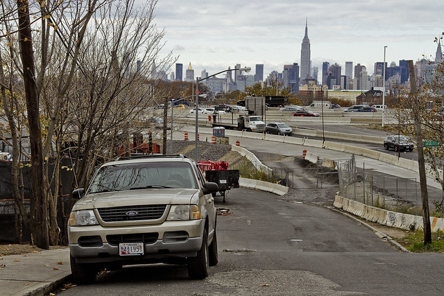
As I’ve mentioned several times recently, an effort is under way to revisit a number of spots which I’ve not set foot in for a while. When I first began wandering around Newtown Creek and the neighborhoods surrounding it, a point was made to visit every single block, but in recent months and years, temporal exigency has caused one to travel along “efficient” routes to get from Point A (A as in Astoria) to Points B, C, and so on.
Accordingly, since I seem to have all the time in the world at the moment, I’m taking the road less travelled and revisiting a few locales which have been off my radar for a bit. To wit, pictured above is the view from 53rd avenue at the angle between Sunnyside and West Maspeth, looking west towards the BQE/LIE interchange.
– photo by Mitch Waxman
Prior to the installation of the two highways, roughly 75-80 years ago, this was a place where working people still lived. There was a neighborhood here, at the western border of Newtown’s Maspeth section and the eastern border of LIC’s Blissville subdivision. That’s when Robert Moses, with his New Meeker Avenue Bridge (Kosciuszko Bridge), and Brooklyn Queens Connecting highway, and Long Island Expressway came to town. Zoning decisions made in Manhattan during the post WW2 era rendered this area as “M1” – meaning it is designated for heavy manufacturing usage only.
Regardless of how the City people decided this land should be used, residential usage continued and there are still a small number of fairly ancient homes found peppered in amongst the warehouses, factories and construction oriented tower crane storage yards hereabouts.
– photo by Mitch Waxman
Funny thing is that this neighborhood is – observationally – one of the last places in NYC where you can “leave your front door open.” Saying that, when I use the term “concretized devastations of Western Queens” this section of industrial Maspeth is what I’m usually thinking of.
Most of the surviving homes I see in this neighborhood are typified by what you see above, wood frame row houses which date back to around 1900 or so. There’s a few older houses nearby which are a bit “grander” and speak to an earlier incarnation of this area. A few have disappeared “under my watch,” and have been replaced with bland cinder block warehouse or industrial buildings. Can’t really speak to “who” lives here, amongst the cranes and highways.
– photo by Mitch Waxman
All I can tell you is that they have an amazing view. This POV is on the rising bluff which once led to a prominent hill to the south called Berlin. The next highest prominence to the west would have been Laurel Hill, which Calvary Cemetery was carved into. This section of Maspeth was actually called “Berlin” until the First World War, when it was changed for obvious reasons to West Maspeth. To the east, the land’s declination rises until it meets a ridge which signals the beginning of the terminal moraine of Long Island nearby Mount Olivette and Lutheran Cemeteries. That ridge, which sports the same sort of rocky geology that lends its name to Ridgewood, is “real” land. Everything west of Laurel Hill is elluvial fill deposited by glacial process and sediment delivered by flooding from the Newtown Creek and East River.
Climate change and rising sea level wise, this likely will be the East River coastline someday.
– photo by Mitch Waxman
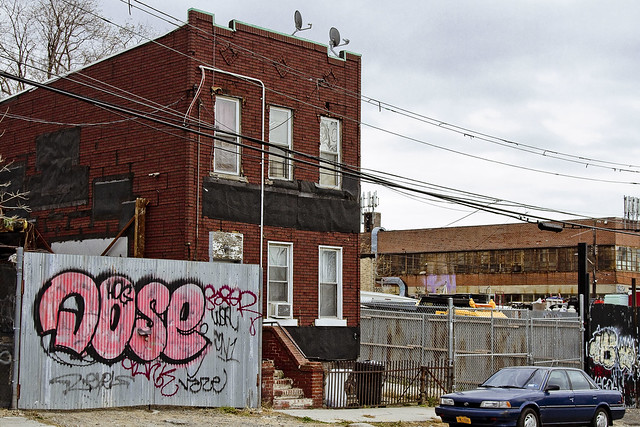
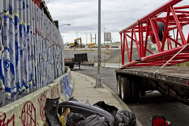
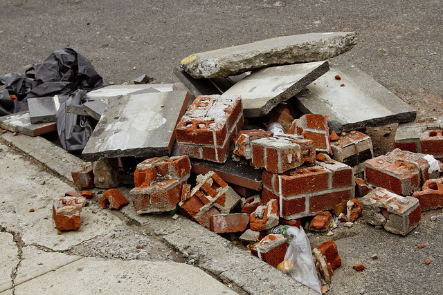
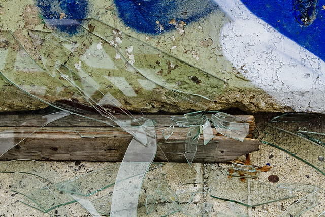
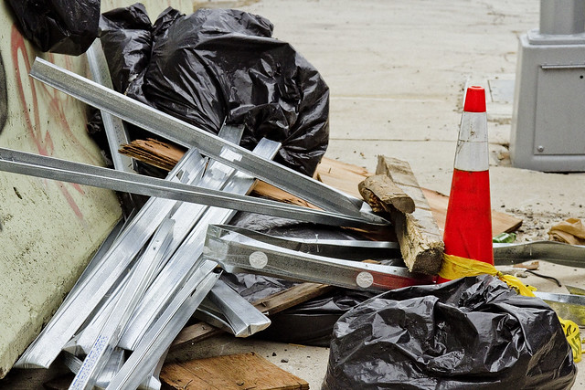
Looping around to the south, as the BQE and LIE interchange cut off egress east/west, an ad hoc art gallery is encountered. Illegal dumping, as I’ve often opined, is the unofficial nativist art form of the Borough of Queens. Combined with long fence lines that are covered in crude graffiti, you’ll encounter several installations along this route which offer intriguing intellectual postulates from the local artistic community.
Everything here is artisanal, incidentally.
– photo by Mitch Waxman
The reality of these installations are that this is simply a convenient place for a low level building contractor to dispose of construction debris without having to pay a dumping fee, but allow me to stay “high brow” in my assessments.
These dumpers really do seem to pay some attention to composition and color, however.
– photo by Mitch Waxman
53rd avenue terminates in a parabola which carries it into 43rd street, a colonial era pathway that once connected to Newtown Creek from Bowery Bay in Astoria. The road transected the properties of (amongst several other famous Dutch and English family names from the colonial era) the Riker’s, Skillman’s, and Alsops along its route, and according to the historic record – it was paved with crushed oyster shells. All that changed, of course, when first the Long Island Railroad and later Robert Moses came to town.
43rd street still exists in a fairly unbroken line from Astoria to Northern Blvd. and then crosses the Sunnyside Yards south into Sunnyside where it crosses Queens Blvd. and Greenpoint Avenue. When it crosses under the Long Island Expressway overpass, it resumes its pre municipal consolidation name – Laurel Hill Blvd.
– photo by Mitch Waxman
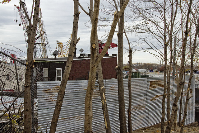
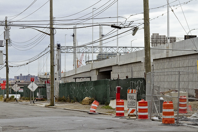
The “43rd street” you encounter in this section of industrial Maspeth, however, is disconnected from the northern section. The last homes on 43rd street went “bye-bye” just a few years ago, due to a smallish construction project going on in the area. With fewer people watching, and caring, the artisanal illegal dumping in this area has amplified.
– photo by Mitch Waxman
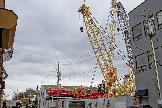
In the shot above, you can discern why I sometimes refer to this section as the “crane district.”
You can also plainly see the sharp rise in altitude hereabouts. This is, as mentioned, largely an industrial zone. There’s a lot of heavy industry going on. Warehouse operations, severely heavy truck traffic, waste transfer stations – Newtown Creek is just a few thousand feet to the south.
– photo by Mitch Waxman
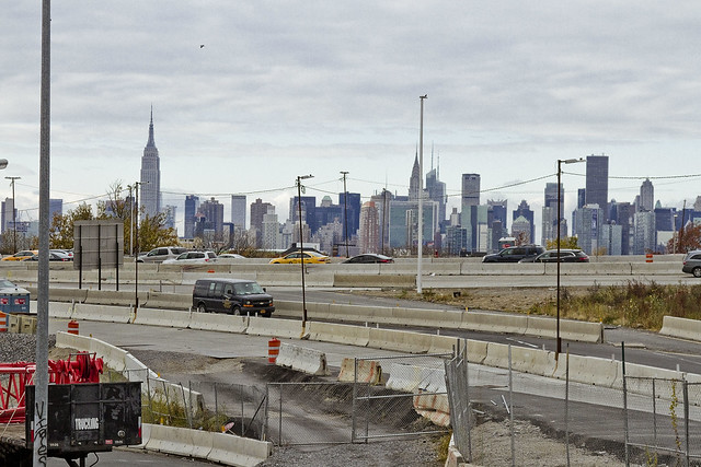
Speaking of Newtown Creek, that smallish construction operation I mentioned earlier is the Kosciuszko Bridge replacement project, which crosses the waterway. If memory serves, that means that something like a half million vehicles a day pass through this pass between Berlin and Laurel Hills. The Kosciuszko Bridge was opened in 1939, and the Queens side approach was built into a shallow valley found between the two landforms, and over a lost tributary of Newtown Creek which was called “Wolf Creek.”
– photo by Mitch Waxman
That’s that, then. See you next week, at this – your Newtown Pentacle.
“follow” me on Twitter- @newtownpentacle
dominant concern
I hate Christmas, but I do like puppies.

– photo by Mitch Waxman
This is the worst time of year for one such as myself. The forced social encounters at Christmas parties, the darkness, the cold. One gets invited to a few holiday parties, which I agree to go to, then back out of the day of. This is kind of a dick move on my part, it is realized, but in reality I’m trying to spare the party giver that certain shadow which I carry around with me. Nobody actually wants me around their homes during the holidays, just like a kitchen fire. Y’know how a lighthouse looks? The bright beam of light scanning about? Imagine a beam of utter darkness emanating from it instead, that’s me.
During December, I always feel like some demon cursed and quite useless object that spreads an acerbic contagion to whatever it touches, or a tumor.

– photo by Mitch Waxman
I prefer to work on updating my enemies list during December, looking through my calendar for those who’ve slighted or annoyed me during the preceding year, and begin to develop my plans for exacting vengeance on them. There’s a few people out there who I can already tell you will be having a very difficult time of it in 2017. Bah.
Usually, when I say “bah,” somebody chimes in with “humbug.” I don’t know what a humbug is, but I suspect it’s one of those angry red razor bumps people get from ingrown hairs.

– photo by Mitch Waxman
It’s best for all that one remains secure in his hermitage this time of year. The humans all seem happy to be enacting their odd rituals, giving manufactured items to each other in the presence of a tree which they’ve had killed and then brought into the house. Luckily, the seasonal bacchanal ends in a couple of weeks,
Bah.
“follow” me on Twitter- @newtownpentacle
dread aperture
There’s so many of us, at least for a couple of hours each day.

– photo by Mitch Waxman
Scuttling down Skillman Avenue and approaching Queens Plaza, one was reminded of a conversation recently enjoyed with a locally deployed NYPD Commander about the unique nature of this area. For a couple of hours, each morning and evening, this is theoretically one of the most densely populated places on the planet, but the individual members of this population blob are seldom in the neighborhood for longer than a few minutes and they are in vehicular motion (however stunted) the whole time.
To put it simply, the multitudes moving through western Queens during the rush hours, on their way to work or home to other places – traveling by car, bus, subway, railroad, bicycle, or autogyro perhaps – create a statistically irrelevant but nonetheless astounding jump in the “persons per square foot” or population density of LIC. Thing is, lots of people elected to suffer a long commute when they moved to Eastern Queens, or Nassau and Suffolk counties.
Lots of time to read, I guess.

– photo by Mitch Waxman
Statistical relevance is part of how planning decisions are made. It big math – “quant” stuff, actually, and beyond my understanding. The theory behind the relevance of statistical information is summed up by that quote from Josef Stalin that a single death is a tragedy whereas a million deaths are a statistic. A lot of policy decisions revolve around, or at least they’re supposed to, the greatest good for the greatest number.
“Greatest number” inherently means that someone gets left out, which translates as “not statistically relevant.” Planning of public works in recent decades has strived to expand and include traditionally marginalized groups, most notably folks with health related mobility issues – thanks to the ADA or Americans with Disabilities Act. A lot of public spaces and City buildings out there were formally denied to people in wheelchairs, since the era in which most of these public buildings were erected, the disabled population wasn’t considered as being “statistically relevant.”
Access to mass, affordable, and reliable transit – which parallels what’s available to “abled” people – still remains a problem, I’m told.

– photo by Mitch Waxman
Statistical relevance, I’m informed, is a big part of the algorithm under which the 311 service of NYC was designed to operate. One person from Blissville complaining to 311 about a cat in a tree is low priority and statistically irrelevant, but the City will send somebody out when they can. Twenty people from the same block call 311 about the cat? Help is on the way a lot faster, as the problem is now far more mathematically relevant and the City will send out Superman to investigate and mitigate.
Make me wonder what would happen if everybody who was commuting through Queens Plaza on any given day suddenly called 311 to complain about something.
Then again, I wonder why it is that everyone doesn’t vote on Election Day.
“follow” me on Twitter- @newtownpentacle
possible reinforcements
Block by block in LIC, from grave to rail.

– photo by Mitch Waxman
In a post last week – I mentioned that shortly after visiting the Kosciuszko Bridge construction site, the burning thermonuclear eye of God itself had managed to burn off the atmospheric gray miasma which had occluded it. As I moved inexorably northwards back to Astoria, via First Calvary Cemetery, the sky – and light – seemed to get better and better.
Pictured above is the skyline of the Modern Corridor of LIC, rising beyond the tombstones set into what those who lived during the colonial era would have called Laurel Hill. Note the change in elevation. The flood plain of the East River and the Newtown Creek is what they’re built on. Back here in Blissville, the ground begins to rise as you head eastwards towards the start of the terminal moraine of Long Island in Maspeth, and the bluff which gives Ridgewood its name.

– photo by Mitch Waxman
That’s the main gate of Calvary Cemetery above, stout ironwork which is decorated with the fasces of the Romans. Obviously, leaving Calvary is a privilege, as most who enter it stay there forever. In the distance, beyond the Queens Midtown Expressway section of the world’s longest parking lot – called the Long Island Expressway (in hushed whispers) – is the Degnon Terminal. The former industrial park adjoins LIC’s tributary of Newtown Creek, called Dutch Kills.
The street closest to the gates is Greenpoint Avenue. To the left, or south – is the infinity of Brooklyn.

– photo by Mitch Waxman
The LIE arrived in Long Island City as the same time as the Midtown Tunnel, and a year after the Kosciuszko Bridge opened. It cut LIC in half, but when you’re in the “House of Moses,” that’s a typical and oft repeated story. An argument I often end up in is with those who have grown up in Western Queens who tell me that they don’t live in LIC. They’ll claim Sunnyside or Astoria are distinct, separate, and that LIC is “over there.”
If you live in a zip code that starts with “111” you live in Long Island City. That’s the code associated with the municipality’s former holding by the United States Post Office. Using the example of the “Miracle on 34th street” movie, if th USPS says it – it’s true. I win.

– photo by Mitch Waxman
This used to be Hoffman Avenue, in a time during which virtually no one currently alive would remember. It’s in Sunnyside, which is the name assigned to the neighborhood surrounding Queens Blvd. shortly after the IRT Flushing Line was built and opened. The so called “Philadelphia plan” rechristened the north/south “named” streets of “Long Island City” heights, later Sunnyside, with numbers instead of names like “Bliss” or “Lowery” or “Laurel Hill Blvd.”.

– photo by Mitch Waxman
An east/west avenue, Skillman is named for an old farming family and provides the century old southern border for the Sunnyside Yards. There used to be a “Pest House” nearby, during colonial and early 19th century times, where sick and dying residents would be quarantined away from the rest of the population to avoid the spread of epidemics. Skillman Avenue is built on a bluff, or ridge, that used to look down on the pestilential swamps that sat between it and through which Jackson (modern day Northern Blvd.) Avenue was built.
All of that changed with City consolidation in 1898, and the later construction of the gargantuan Sunnyside Yards by the Pennsylvania Railroad company at the start of the 20th century. Robert Moses renamed the stretch of Jackson Avenue that goes from 31st street to Flushing as Northern Blvd.

– photo by Mitch Waxman
Famously, I can describe where you’ll find every single hole in the fencing surrounding the 180 plus acre Sunnyside Yards complex is located, and the one which provided vantage in the shot above is one of my favorites. It overlooks the Long Island Railroad Main Line, which has been carrying commuters from east to west, and back again, since 1870.
“follow” me on Twitter- @newtownpentacle
