Archive for the ‘Pickman’ Category
perceptibly when
DUGABO at night, in today’s post.

– photo by Mitch Waxman
The reliable Greenpoint Avenue Bridge is a double bascule drawbridge which spans the Newtown Creek, connecting the Greenpoint section of Brooklyn with the Blissville section of Queens. Heavily travelled, there are two access roads alongside the bridge which lead down to the aptly named Railroad Avenue. This is the latest Greenpoint Avenue, or John J. Byrne memorial, Bridge. The 1900 vintage bridge which the modern version replaced was just to the west of the modern span, sat in the footprint of the access road in the shot above, and it carried railroad tracks. There have been five Greenpoint Avenue Bridges, this is the 1987 model which is a renovated version of GPA Bridge #4. It’s 1.37 miles up the creek from the East River, and opens a few times a day to allow tugboats and oil barges egress.
The 1850’s original was called the Blissville Bridge, and it was made of wood.

– photo by Mitch Waxman
Railroad Avenue is the very definition of what I often refer to as “the concrete devastations of Western Queens.” Formerly, this area was remarkable for the presence of the Tidewater Pipeline company (a Standard Oil subsidiary) and the Buckeye Pipeline. In recent years, the Broadway Stages company has been buying up property along the bulkheads in pursuance of creating TV and movie filming locations. Their desire to maintain the “real” and “gritty” side of LIC for theatrical usage has accidentally turned the company into building preservationists.
If the area looks familiar to you, you’ve likely seen it in some of the Marvel Netflix productions like “Punisher” or “Daredevil” that were filmed down here. Every cop show in NYC has done a scene hereabouts as well.

– photo by Mitch Waxman
If you follow Railroad Avenue to its western terminus, you encounter the Sims Metal recycling works. Sims has been mentioned too many times to count at this – your Newtown Pentacle – so I’d ask you to just type “Sims” into the search box at upper right of this page to check them out. Suffice to say that in addition to handling all sorts of scrap metal and junk cars, Sims Metal also enjoys a municipal contract with the City of New York which sees them handling the metal/glass/paper curbside recycling program (blue and clear bags) that the Department of Sanitation operates.
If you were here during during the work week or in the daylight hours, on Railroad Avenue in Blissville, there would be dozens and dozens of heavy trucks and DSNY vehicles idling while waiting for their chance to tip out their collections at Sims. All of these trucks transit through Blissville, some come twice a day.

– photo by Mitch Waxman
The Blissville Yard of the Long Island Railroad is an MTA owned facility. Up until the 1990’s, there was regular passenger service along these tracks, which are known as the Lower Montauk.
Today – the name of the game on the Lower Montauk is freight, and the Blissville Yard is used to build the up the linked box cars of the garbage train, six days a week. In tomorrow’s post, I’ll show you the other side of Railroad Avenue, where the black bag or putrescent garbage goes for processing, and loading, into these green box cars.
As a note, the shots being presented in today’s post are all long exposures. Railroad Avenue literally has no street lights, and it’s only ambient glow from the industrial lots surrounding it illuminating things.
Figuring that somebody would ask, in between the tripod shots I cracked out a handheld one that accurately depicted something closer to what the naked eye can see down here at night – this one.

– photo by Mitch Waxman
These oil tanks are now part of the Broadway Stages properties portfolio, but they were once known as the Lukoil/Getty dock. The signage on the fence indicates that the pipe you see in the lower left hand corner is a now inactive valve for the Buckeye Pipeline. The building in the distance is the former Tidewater facility that juts up against the bulkheads of Newtown Creek.
Getty is one of the family of oil companies (a subsidiary of Mobil, I believe) which were initially named in the 2010 Superfund decision by the EPA. More recently, Sims Metal and the Long Island Railroad have been added to the list of “potentially responsible parties.” The City of New York itself is one of the bad guys, too.

– photo by Mitch Waxman
That’s the western side of Railroad Avenue, here in Blissville’s DUGABO (Down Under the Greenpoint Avenue Bridge Onramp), for you. Waste Transfer stations, fading oil infrastructure, movie and TV sets, no street lights or sidewalks. Tomorrow, I’ll show you the eastern side of DUGABO.
Your first thought, just like the Mayor, must be that it would be ideal to site a gargantuan homeless shelter nearby, right? What could go wrong with that idea?
“follow” me on Twitter- @newtownpentacle
thunderous declamations
Instead of Iowa or Texas, the Mayor ought to come out to Queens once in while, just in the name of “Equity.”

– photo by Mitch Waxman
The Long Island Expressway rises out of the Queens Midtown Tunnel in the Hunters Point section of Long Island City, and follows the route of Borden Avenue on a high flying steel truss which is at its height 106 feet over the waters of the Dutch Kills tributary of Newtown Creek. According to the NYC DOT’s 2015 numbers, this section of “495” is called the Queens Midtown Expressway and it carries nearly 85,000 vehicle trips a day. It comes back to ground at the border of the Sunnyside and Blissville sections of Long Island City, at Greenpoint Avenue.
That’s about 31 million vehicle trips a year rolling through LIC, and in particular – Blissville. The shot above represents exactly thirty seconds worth of traffic on a corner one block away from the entrance/exit to the LIE. Thirty seconds… keep that number in mind when looking at the shots in today’s post. They’re all thirty second exposures.

– photo by Mitch Waxman
That’s the LIE itself, shot from the access road which feeds down onto Borden Avenue in an area I call the “Empty Corridor.” I was down there just a couple of weeks back, and the zone was discussed in this post. For the sake of trivia – the LIE opened on the 15th of November in 1940.
The northern border of Blissville is formed by the Long Island Expressway and the Empty Corridor. Saying that, if you’re on the north side of the LIE, you’re still in Sunnsyide.

– photo by Mitch Waxman
On the Blissville side, rivers of steel flow past you on the local street/access road modernity calls Borden Avenue. Named for where it was going, namely the Borden Dairy farm in Maspeth, Borden Avenue was created as a wooden plank road in 1868 that connected the western end of the road with the East River shoreline, and with the upland agricultural properties to the east. Originally, this raised roadway – designed for mules and oxen pulling milk wagons – crossed through the malarial swamps surrounding Dutch Kills.
By the early 20th century, the swamps had been drained or filled in, and Borden Avenue was paved with belgian block and later macadam and asphalt. It became an industrial corridor whose path more or less mimicked that of the Long Island Railroad’s Lower Montauk Branch tracks found just to south, along the bulkheads of the Newtown Creek.

– photo by Mitch Waxman
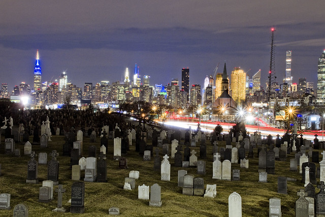
To the east of Borden Avenue is Greenpoint Avenue, which was built into its current path in 1852 from a dirt road. On one side of the street, since 1848 at least, First Calvary Cemetery will be found. When it opened, Calvary wasn’t even half the size it is now. Acquiring property through inheritances and purchases, the cemetery didn’t attain its current borders until the early 20th century, just before the First World War. There are literally millions held in the loam.
Blissville itself is named for one of its founders, Greenpoint’s Neziah Bliss. It was developed with Eliaphet Nott of Union College, and the goal was creating one of those utopian worker’s hamlets which were all the rage amongst wealthy Protestant industrialists in the years leading up to the American Civil War. There were meant to be no bars or saloons in Blissville, but in the 1850’s when the railroad began to be driven through, the Irish laborers working on the iron road put an end to all that. Additionally, the masses of people coming to Calvary from the Five Points and Lower East Side to visit the graves of loved ones created a demand for inns and bars.
Blissville was one of the five communities which seceded from the Newtown Municipality to form Long Island City in 1870.

– photo by Mitch Waxman
According to a 2015 report from the NYC DOT, the Greenpoint Avenue (aka John J. Byrne memorial bridge) Bridge carries 28,361 vehicle trips across Newtown Creek on a daily basis. That’s 10,351,765 vehicles a year heading to and from Brooklyn’s Greenpoint to Queens’ Blissville. The traffic feeding through Blissville is (observationally) going in three main directions once it enters Queens; a) north on Greenpoint Avenue towards the LIE and Sunnyside, b) north west on Van Dam towards Queens Plaza, and c) east on Review Avenue towards Maspeth and Middle Village.
The second largest oil spill in the United States is the Greenpoint Oil Spill, the epicenter of which is less than half a mile east on the Brooklyn side of the Greenpoint Avenue Bridge. Similarly, an oil spill of still unknown size lurks in the soil of Blissville less than half a mile east of the Greenpoint Avenue Bridge. The bridge itself crosses the Newtown Creek, a Federal Superfund site notorious for the 1.8 billion gallons of raw sewage which the NYC DEP dumps into it annually.

– photo by Mitch Waxman
According to the Blissvillians whom I’ve met, the population of this neighborhood is around 220 people although I’ve also heard 500 (seems a bit high, 500). It’s the usual demographic mix of Queens hereabouts, but with the proviso that almost everybody would describe themselves as “working class.” There’s a generational community here which has held out in the post industrial landscape of Long Island City – despite the traffic and the pollution and the industrial character of the neighborhood. All told, about 4-6 blocks square blocks are the totality of Blissville, Queens. The nearest subway is on Queens Blvd. in Sunnyside, and the two bus lines running the area are in service on neither a twenty four hour nor seven days a week schedule. There are no schools, hospitals, or supermarkets. There are a lot of City owned properties, warehouses, and waste transfer stations.
Mayor Bill de Blasio’s Department of Homeless Services, therefore, has decided that this is the ideal and “appropriate site” for a third homeless shelter (within a half mile of the LIE) to be opened in the neighborhood. This time around, it will be the 2008 vintage and 154 room Fairfeld Inn, found at 52-34 Van Dam Street, that becomes a shelter. Blissville anticipates some 400 people will be installed in this building. Another Hotel on the Sunnyside side of the LIE has been converted to a shelter, as has a former Public School on Greenpoint Avenue.
Blissville could use your help with all this trouble the Mayor is sending their way, Queensicans. A Department of Homeless Services public hearing will take place on Thursday the 15th of March at 6:30 p.m., at St. Raphael’s Church located at 35-20 Greenpoint Ave.
Let’s tell the Manhattan people what the Ides of March are like in Queens, and let the Dope from Park Slope know that enough is enough.
“follow” me on Twitter- @newtownpentacle
learned abroad
Is it “Hell in a hand basket,” or are our hand baskets sending us to hell?

– photo by Mitch Waxman
One of the very few places where my personal ideology aligns with that of the Dope from Park Slope – aka the current Mayor of the City of Greater New York – concerns discouraging the continued usage of those plastic shopping bags that every shop in NYC jams their goods into. I’m old enough to remember when the then ubiquitous brown paper bag was phased out in favor of these things. The excuse at the time was that “it saved trees” not using paper.
Of course, in the current era of ubiquitous municipal recyling programs, those paper bags would be worth a small fortune on the “pulp” market. The plastic ones, well, they ain’t exactly saving any trees here in Queens.

– photo by Mitch Waxman
This unfortunate example of the urban arbor is found on 43rd street, just off Northern Blvd. It serves the community as a rake set high into the air column, gathering unto itself wind blown trash. Given that the common plastic grocery sack couldn’t be better designed, as far as parasailing, the air is sometimes thick around Western Queens with these things. Ask my colleague Will Elkins (at Newtown Creek Alliance) about how many of these things he scoops out of the water every year.
Plastic, ultimately, is a waste product of the oil refining process, just like asphalt. That means that the manufacture of new plastic items, in particular poly vinyl chloride based ones, uses a super cheap “feed stock” and are massively profitable to produce and sell accordingly. If some science fiction like limitless and clean energy source was discovered today, we’d still be using petroleum a century from now, so this is a problem that isn’t going away.
People from industrialized countries might say “oil? if we went all “sci fi power source,” it would disappear.” Remember that right now and today in 2018, at least 50% of all living humans use wood fires to heat their homes and cook their food. Coal is still used in massive quantities all over the world, and the underlying technology behind even a nuclear power plant is ultimately a steam driven engine. “Installed base” is the conversation, not fuel source. Just saying.

– photo by Mitch Waxman
One of the things which right wingers opine about environmentalists is that they often have no idea what they’re doing and have just jumped onto an issue because it’s fashionable. They will point out misreadings of climatological data which predicted a new ice age starting in the 1990’s, or mock the banning of CFC accelerants and the so called “Ozone Hole” during the late 1980’s. They will declare many, many things which paint a picture of vainglorious hippies tilting at imaginary windmills that just get in the way of National Business, and which put “hard working Americans” out of work. The more extreme amongst them will say that this all part of God’s plan for us, and not to worry about the natural environment. Faith sustains, not nature.
I submit the photos in today’s post, and ask “did the trees in Eden look like this”?
“follow” me on Twitter- @newtownpentacle
magic evening
Nothing’s easy.

– photo by Mitch Waxman
One hates going into the City, or Manhattan for those of you who didn’t grow up in Brooklyn or Queens, so very much that a tendency has developed in a humble narrator to cluster together errands and get them all done in a single go. Tax season is upon us all, so a trip to my “numbers guy” and his accountancy office was required. Additionally, a quick stop at “Beards and Hats” or the BH Photo store to purchase supplies for various endeavors was on the list.
When I left the neighborhood, I put the guy pictured above in charge, but I think a poor choice was made regarding my choice of deputy given that he was out cold before I even got on the R train.

– photo by Mitch Waxman
A quick stop in Jackson Heights was executed first, wherein Our Lady of the Pentacle and myself indulged in a meal at one of the local curry shops. Our chosen dining location was of the buffet type, and while filling a plate with exotically spiced chicken and well cooked rice and vegetables, a humble narrator was approached by a strange woman.
She informed me that I was “going to purgatory” and walked away. Despite my questioning of her curious pronouncement, that was all she had to say. My theory is that she misread the Newtown Creek Alliance “NCA” hat I was wearing as NRA, but then again she was probably just another nutcase. I attract them flies to poop, after all.
After eating, Our Lady and myself climbed the stairs to the 7 line subway tracks and boarded a train heading towards the Shining City itself.

– photo by Mitch Waxman
As is my habit, whilst on the 7, I found a relatively clean window and pointed the camera at various points of interest. Pictured above is the Sunnyside Yards, and the fleet of trains which LIRR, NJ Transit, and Amtrak store in Queens between peak demand periods – the so called “rush hours.”
To anyone reading this who works in Government, or the Transit sector, or in the Non Profit Industrial Complex – the old 9-5 concept only applies to you. Corporate America has long abandoned the “English week” of eight hour workdays. The rest of us are doing everything we can to keep our heads above water, and that involves staying late and coming in early as well as showing up sometimes on a Saturday to help out. Additionally, “rush hour” begins at about 5:30 a.m. and lasts till 10:30 a.m. due to staggered work shifts. In the afternoon, it actually starts around three and lasts till nine. Please staff accordingly.

– photo by Mitch Waxman
We arrived in Manhattan, and boarded the vertigo inducing escalators at the 7 line’s terminal stop at Hudson Yards.
“Beards and Hats” was – as always – a model of customer facing commercial efficiency, and even with a bit of browsing amongst the shelves we were out of there in about a half hour.

– photo by Mitch Waxman
Being a relatively nice day, and knowing that lousy weather had been forecasted for the middle of the week, we opted to walk from BH photo at 34th street to our tax appointment with the Accountants nearby 72nd and Broadway.
Upon arrival at the office, however, we were told that our number cruncher was seriously behind schedule and we would have to cool our heels in the waiting room for at least an hour. Everybody else in the waiting room had “gone to the phones” as I descirbe it, including Our Lady of the Pentacle. I instructed her to text me if anything sped up, and that I’d be back in a little while if she didn’t mind waiting without me. She didn’t.

– photo by Mitch Waxman
One didn’t want to wander too far afield, and I wasn’t fully equipped (or inspired) to do full on night shots, but – I did have a tiny little tripod with me. A couple of set ups followed, the one above is looking downtown along Broadway towards Columbus Circle.
Incidentally, has the Mayor considered the fact that if he pulls the statue of Columbus down and renames the roundabout at 59th and Broadway, he will be forced to then rename Columbus Avenue and compel Columbia University to change their name? Just saying…

– photo by Mitch Waxman
A long time ago, I used to live waaaaay north of “the Dorilton” building found at west 71st street. It’s a handsome beaux arts “block of flats,” built in 1902 and a landmark. It was originally called “the Weed” when it was built, after its developer Hamilton Weed. It’s architects were the firm of Janes and Leo.
For some reason, it’s always filled me with a sense of foreboding and seems to be pulsing with some latent occult potency. God only knows what goes in there, but who can guess what the moneyed classes do behind closed doors? There’s probably roasted baby being consumed in there. brrrr…

– photo by Mitch Waxman
After finally sitting down with the accountant, and working out exactly the financial tithe to war and waste which Our Lady and I owed to both the Federal and NYS political establishments, we decided that a quick trip back to Astoria was in order. Our little dog Zuzu had been alone all day waiting for us, and you don’t want to make an elderly dog angry. The plan was simple – get to 42nd street and then transfer to a Queens bound R.
Have I mentioned that the “A” in MTA is for “adventure?”

– photo by Mitch Waxman
After waiting for a period of time considerably in excess of my visit to “Beards and Hats” and which promised to approach that of my delayed appointment with the Accountant, we decided that the likelihood of an “R” showing up was slight. MTA hit us with a great fakeout when an N line train appeared using the rolling stock you normally see on the R line.
They have some sense of humor, I tell you, those guys and gals at the MTA.

– photo by Mitch Waxman
Having resigned ourselves to walking from 31st street back to HQ, which is only two blocks from an R stop as a note, the N pulled into Queens Plaza and announced that the train was going to go express to the terminal stop at Ditmars and 31st. “Why do they do this” asked several of my fellow riders. Having zero barriers or inhibitions about talking to strangers, a humble narrator had to opine to my fellow commuters the probabile reason we were standing on a train platform in Queens Plaza at 8:30 p.m. after getting turfed off the one we were on.
Simply put, MTA rates its on time performance by measuring when a train leaves one terminal stop as compared to that of its arrival at the one on the other end of the line. Should a train set get delayed doing local stops, particularly common in Manhattan, MTA’s practice is to switch the train to express to make up the lost time. This is why you’ll periodically see the train you’ve been waiting for speed by the platform with no one on board. Their (MTA Bosses) job performance review is more important to them than yours, and you’ve been cited several times for showing up late to work because of their desire to be “on time.”

– photo by Mitch Waxman
While we were waiting, one again waved the camera around at points of passing interest. Luckily, the 7 was sitting at the platform for a good ten minutes so I had something nice and static to photograph.
Were there a so called “walking transfer” available between Queens Plaza (upstairs) and Queensboro Plaza (downstairs) we would have tried our luck with catching an R or M back to our actual destination but c’est la vie. Unfortunately, MTA still operates the IRT and IND lines as if they the separate entities of the dual contract era, even when it comes to fare control.

– photo by Mitch Waxman
When a local stop N line train finally arrived, we boarded. A debate about which stations are currently under construction began, wherein Our Lady was forced to ask google about it. I know this is probably heresy, but if there was a single piece of signage explaining it to the ridership found in the cars…
Bah. I relieved the shopping cart guy from watch when I got home, and got back to my malingering amongst the rolling hills of almond eyed Astoria.
I did wonder a bit about that purgatory comment from the crazy lady back in Jackson Heights.
“follow” me on Twitter- @newtownpentacle
no prophet
Back in the dark, in Blissville.

– photo by Mitch Waxman
Last week, Newtown Creek Alliance organized an event in Ridgewood at a local pub which was both a “meet and greet” and an informational event. After it ended, my pal Hank the Elevator Guy offered me a ride towards Astoria in his automobile, but I asked for and instead received a quick lift over to DUKBO.
Hank the Elevator Guy was concerned for my safety, and asked if I was armed. I was, with a camera and tripod. What are you kidding, it’s Newtown Creek – that’s my house. The Kosciuszcko Bridge beckoned, so I headed over to Laurel Hill Blvd. alongside First Calvary Cemetery and got busy with the clicking and the whirring.

– photo by Mitch Waxman
The NYS DOT and their contractors are using a pretty good chunk of Laurel Hill Blvd. to store or park construction equipment, and the spot you’re looking at above used to be pretty much where the 1939 K-Bridge stood until it was demolished last year. One attended a meeting with officials from the agency not too long ago, and they indicated that the second phase of the project was on schedule and we’d be seeing both steel and concrete starting to rise out of the site this summer.
They say that everything should be wrapping up in the next 24 months or so.

– photo by Mitch Waxman
One sort of lingered about in the area, as I wasn’t being molested or eyeballed by private security. My plan, as you’ll discern from the shots in today’s post, was to accomplish the latest in a series of long exposure shots I’ve been creating all winter. Also, the climate was comfortable, atmospherically speaking.
Also, in that meeting with the NYS DOT, the head of the project indicated that the footbridge connecting 43rd street on Sunnyside’s southern extant with Blissville’s Laurel Hill Blvd. was not only completely rebuilt but was open for business. Additionally, a style of fencing inspired by the wrought iron of the cemetery fence had been installed on the structure, ideal for sticking a camera lens through, unlike the original model which was clad in chain link.

– photo by Mitch Waxman
The things I was told turned out to be true, and one enjoyed not just the opportunity to gain a bit of elevation over the deck but to also see the new bridge from a different set of angles than have been available for the last couple of years. This shot looks south over the redesigned approach ramp – connecting the Long Island Expressway off ramp to the Brooklyn Queens Expressway onramp, the latter being the road that the K-Bridge carries across Newtown Creek.
– photo by Mitch Waxman
Speaking of the LIE, that’s what it looks like from the pedestrian ramp/overpass that they’ve just built. The old structure was clad in chain link fencing, and despite there being a couple of “Bernie Holes,” here and there – POV options were always limited up here.
For those not in the know, a “Bernie Hole” is a gap in chain link fencing which was opened sometime in the 1980’s or 90’s by my departed pal Bernie Ente. There’s still a few of them around the Creek, and I’m pretty much the only one he ever entrusted the location of most of them to. “Gotta get your shot,” he would opine.

– photo by Mitch Waxman
Crossing under the LIE overpass from Blissville into Sunnyside, a humble narrator did one last setup with the tripod and associated gear. I call areas like this “The House of Moses” after Robert Moses, who slammed his roads through neighborhoods and cemeteries all over New York City and in particular Western Queens.
“follow” me on Twitter- @newtownpentacle


