Archive for the ‘Queens’ Category
shocking coruscations

– photo by Mitch Waxman
Conversation offered by divers and submarine enthusiasts inform this posting, which like your humble narrator, lingers about at Hells Gate.
Explorations of the occluded depths in this area, as reported, reveal a shattered series of reefs and alluvial boulders underlying this region of the East River. In addition there are depressions found in the sediment here, which form enormous cauldron like holes dropping down into the silt choked darkness, and I am informed that such formations are commonly called “pots” by those familiar with such subaqueous geography. Within these pots might be found a hodge podge of archaeological record, but the strong currents above them form venturi effect vortices within, and any who might enter one are considered to be extraordinarily lucky to exit such a feature intact and alive.
from “Myths and Legends of our Own Land, by Charles M. Skinner” at gutenberg.org
Satan appears to have troubled the early settlers in America almost as grievously as he did the German students. He came in many shapes to many people, and sometimes he met his match. Did he not try to stop old Peter Stuyvesant from rowing through Hell Gate one moonlight night, and did not that tough old soldier put something at his shoulder that Satan thought must be his wooden leg? But it wasn’t a leg: it was a gun, loaded with a silver bullet that had been charged home with prayer. Peter fired and the missile whistled off to Ward’s Island, where three boys found it afterward and swapped it for double handfuls of doughnuts and bulls’ eyes. Incidentally it passed between the devil’s ribs and the fiend exploded with a yell and a smell, the latter of sulphur, to Peter’sblended satisfaction and alarm. And did not the same spirit of evil plague the old women of Massachusetts Bay and craze the French and Spaniards in the South?

– photo by Mitch Waxman
Rumors which have persisted since the advent of European colonization suggest that great treasures might by found in these deep eddies and swirling maelstroms of the underwater grottoes. Famously, the wreck of a British ship called “the Hussar” carried a great fortune and many lives down to the bottom of Hells Gate- and the aboriginal inhabitants of the archipelago related stories of a race of giants who originally inhabited these islands that would cross the river by merely stepping across the rocks. Of course, there used to be a lot more rocks, before the Army Corps of Engineers set off the greatest manmade explosion (until Hiroshima) in history to “assure navigability”.
The effort to clear “flat rock”, “frying pan”, “pot rock”, “Flood Rock”, and “Hallet’s Point Reef” was explored in some detail in a Newtown Pentacle Posting of June 5, 2009- “The River of Sound”, and the enigmatic Hells Gate Bridge and its environs was discussed in some detail in the September 23, 2009 posting “A Bright Passage”.
from “Myths and Legends of our Own Land, by Charles M. Skinner” at gutenberg.org
Back in the days before the Revolution, a negro called Mud Sam, who lived in a cabin at the Battery, New York City, was benighted at about the place where One Hundredth Street now touches East River while waiting there for the tide to take him up the Sound. He beguiled the time by a nap, and, on waking, he started to leave his sleeping place under the trees to regain his boat, when the gleam of a lantern and the sound of voices coming up the bank caused him to shrink back into the shadow.
- At first he thought that he might be dreaming, for Hell Gate was a place of such repute that one might readily have bad dreams there, and the legends of the spot passed quickly through his mind: the skeletons that lived in the wreck on Hen and Chickens and looked out at passing ships with blue lights in the eye-sockets of their skulls;
- the brown fellow, known as “the pirate’s spuke,” that used to cruise up and down the wrathfultorrent, and was snuffed out of sight for some hours by old Peter Stuyvesant with a silver bullet;
- a black-looking scoundrel with a split lip, who used to brattle about the tavern at Corlaer’s Hook, and who tumbled into East River while trying to lug an iron chest aboard of a suspicious craft that had stolen in to shore in a fog.
This latter bogy was often seen riding up Hell Gate a-straddle of that very chest, snapping his fingers at the stars and roaring Bacchanalian odes, just as skipper Onderdonk’s boatswain, who had been buried at sea without prayers, chased the ship for days, sitting on the waves, with his shroud for a sail, and shoving hills of water after the vessel with the plash of his hands.

– photo by Mitch Waxman
A busy industrial corridor in the ominous 21st century, the efforts of engineers have rendered Hell Gate tame and predictable, although one might still observe the occasional spiral eddy and acre wide pools of swirling water near the shorelines on windy days. If one watches carefully, a phastasmagorical plethora of animal forms persists in this part of the river- diving cormorants are common, Birds of Prey are present as are riverine and littoral mammalia, and there are said to be other less well known phyla. Every now and then, one might even encounter a U.F.O. (an Unidentified Floating Object).
Who can guess, after all, what is is that may be hiding down there?
from “HISTORY OF QUEENS COUNTY with illustrations, Portraits & Sketches of Prominent Families and Individuals. New York: W.W. Munsell & Co.; 1882.” at bklyn-genealogy-info.com
Hallett’s purchase at Hell Gate Neck included much of the territory later incorporated as the village of Astoria. The original proprietor lived there to the age of about ninety, and was foremost in many early improvements. He divided his property at that point in 1688 between his sons William and Samuel, the former receiving the lands south of the road Since forming Greenoak Street, St. George’s Place, Welling and Main streets and Newtown avenue, the latter the lands lying north of that road.
It is probable that the Indians who sold Hell Gate Neck to William Hallett were of the Canarsie tribe, a clan of reputed power whose jurisdiction extended over the whole of Kings county, the islands in Hell Gate, and, O’Callaghan says, some part of Newtown. A large tract of land including the southwestern portion of the present city was deeded “to the inhabitants of Newtowne, alias Middleburg,” by Pomwaukon and Roweroenesteo of the above tribe, July 9th 1666.

– photo by Mitch Waxman
Indolent, and quite susceptible to environmental stressors, your humble narrator has commented several times about the odd sonic qualities of this patch of the East River. Mighty Triborough never sleeps, and its steel hums continually. Staccato, the traffic over Hells Gate is no less affecting, but it is just not in the same league as the constant oppression of infrasonic drone emanating from Triborough, or the din of nearby heavy industrial activity on Wards Island.
Here is part of a recording made on May 28th of 2010, directly beneath the Triborough Bridge… using the admittedly poor microphone of an iPhone headset… for your consideration…
from wikipedia
After the war ended, Jaspar Ward and Bartholomew Ward took ownership of the island that later carried their surname. Although a small population had lived on the island since as early as the 17th century, the Ward brothers developed the island more heavily by building a cotton mill and building the first bridge to cross the East River in 1807, connecting the island with Manhattan at 114th Street.
The bridge, paid for by Bartholomew Ward and Philip Milledolar, was a wooden drawbridge. The bridge lasted until 1821, when it was destroyed in a storm.After the bridge was destroyed, the island was largely abandoned until 1840, when the island was transformed into a dumping ground for everything unwanted in New York City. Between 1840 and 1930 the island was used for:
- Burial of hundreds of thousands of bodies relocated from the Madison Square and Bryant Park graveyards.
- The State Emigrant Refuge, a hospital for sick and destitute immigrants, opened in 1847, the biggest hospital complex in the world during the 1850s.
- The New York City Asylum for the Insane, opened around 1863.
- An immigration station from 1860 until the 1892 opening of Ellis Island.
- Manhattan State Hospital, operated by the New York State Department of Mental Hygiene when it took over the immigration and asylum buildings in 1899. With 4,400 patients, it was the largest psychiatric institution in the world. The 1920 census notes that the hospital had a total of 6045 patients. It later became the Manhattan Psychiatric Center.
indefinable odors

– photo by Mitch Waxman
Down by Dutch Kills, one must persevere to maintain some inkling of hope for the future of mankind.
Saying that, however, in its own way Dutch Kills is actually quite a lovely place- as storied industrial centers which have seen better days typically are. A canalized waterway, Dutch Kills is a tributary of that languid cautionary tale known as the Newtown Creek, and has been isolated for several seasons from its principate source by emergency bridge construction and a changing industrial landscape. I’m down here a lot of course, most recently in the “from some point in space” posting of November 3rd, which includes an intriguing set of high elevation shots of the area which I recently managed to capture.
from nyc.gov
Hunters Point Avenue is a two-lane local City street in Queens. Hunters Point Avenue is oriented east-west and extends from 21st Street to the Long Island Expressway/Brooklyn Queens Expressway interchange in Queens. The avenue is parallel to and approximately one block south of the Long Island Expressway. The Hunters Point Bridge over Dutch Kills is situated between 27th Street and 30th Street in the Long Island City section of Queens, and is four blocks upstream of the Borden Avenue Bridge. It is a bascule bridge with a span of 21.8m. The general appearance of the bridge has been significantly changed since it was first opened in 1910. The bridge provides a channel with a horizontal clearance of 18.3m and a vertical clearance, in the closed position, of 2.4m at MHW and 4.0m at MLW. The bridge structure carries a two-lane, two-way vehicular roadway with sidewalks on either side. The roadway width is 11.0m, while the sidewalks are 1.8m wide. The width of the approach roadways vary from the width of the bridge roadway. The west approach and east approach roadways are 13.4m and 9.1m, respectively.
The first bridge at this site, a wooden structure, was replaced by an iron bridge in 1874. That bridge was permanently closed in 1907 due to movement of the west abutment, which prevented the draw from closing. It was replaced in 1910 by a double-leaf bascule bridge, designed by the Scherzer Rolling Lift Bridge Company. The bridge was rebuilt in the early 1980’s as a single-leaf bascule, incorporating the foundations of the previous bridge.

– photo by Mitch Waxman
Seldom commented, the Hunters Point Avenue Bridge segments Dutch Kills neatly, and has done so for nigh on a century now. The marshes and streams which once typified the area before the advance of railroad and vast agglutination of industrial installation are long gone, relegated to subterranean sewers and masonry clad spillways, but a century ago- the Hunters Point Avenue Bridge (and its predecessors) allowed egress between the terrestrial isolation of the Long Island City center and the rest of western Queens.
The NY Times, in 1908, commented that Long Island City might someday be known as “A city of bridges” due to the many crossings over the tributaries of the Newtown Creek and the presence of mighty Queensboro at its center.
from federalregister.gov
The Hunters Point Avenue Bridge, at mile 1.4, over the Dutch Kills has vertical clearances of 8 feet at mean high water and 13 feet at mean low water. The existing regulations for the Hunters Point Avenue Bridge in 33 CFR 117.801(d) require the draw to open on signal if at least a one-hour advance notice is given to the drawtender at the Grand Street/Avenue Bridge, the NYCDOT Radio Hotline, or NYCDOT Bridge Operations Office. In the event the drawtender is at the Roosevelt Island Bridge or the Borden Avenue Bridge, up to an additional half-hour delay may occur.
The bridge owner, the New York City Department of Transportation (NYCDOT), submitted bridge opening log data to the Coast Guard for review. The bridge owner plans to operate these bridges with multiple crews of drawtenders. The two-hour advance notice should allow sufficient time for the crews to operate these bridges due to the close proximity of the bridges to each other. Recent yearly openings have been relatively low which will allow the bridge owner to utilize the roving crew concept and still meet the needs of navigation.

– photo by Mitch Waxman
The Hunters Point Avenue Bridge (the 1910 version) was configured differently than the modern structure when first built, although the original was constructed for some $95,214 from plans by the Scherzer Rolling Lift Bridge Company with the dirty work performed by the Duseath Engineering Company of 114 Liberty St. NY. As you’d imagine, there is a certain logic behind the esoterica presented about this obscure little bridge found in a literal “industrial backwater” in Queens.
But… I can’t tell you what is is yet…
from nysdot.gov
About 1900, most of the Newtown Creek was bulkheaded and occupied by about fifty industrial properties. Undeveloped or less developed sections without bulkheads included Dutch Kills, about 2,000 feet of shoreline in Queens just above Dutch Kills with two LIRR lighterage piers, about 1,000 feet of shoreline in Queens near the Penny Bridge, and about 3,500 feet of shoreline downstream of Maspeth Avenue in Brooklyn.15 Dutch Kills, and the Queens side of Newtown Creek, just upstream of Dutch Kills, were developed circa 1905-1912, largely through the efforts of the Degnon Terminal & Realty Company. The Degnon firm created an industrial park with rail and marine access around Dutch Kills between about Hunters Point and 47th Avenue, Dutch Kills subsequently was included within USACE dredging projects. Without federal assistance, Degnon created a 150-foot-wide channel with 2,400 feet of bulkhead, including a turning basin. To create rail links to the development, Degnon helped the LIRR build a new 1,000-acre freight terminal circa 1907 along Newtown Creek east of Dutch Kills on property bought from Calvary Cemetery, including several short piers intended to handle heavy freight such as brick, coal, lumber, and ice. From this terminal, a private Degnon Terminal Railroad was created, largely through local streets. On newly filled marshy margins of Dutch Kills, Degnon Terminal & Realty promoted industrial development both on and away from the water. One iron works and several large building materials firms occupied the Degnon waterfront by the early 1920s. Reconstruction of the two movable bridges over Dutch Kills circa 1908-10 contributed to these developments. On other Degnon lots, large firms included the American Eveready Company and the American Chiclet Company, respective makers of batteries and candy.16 Facilitating this growth was the construction of the Queensboro Bridge (1909) and the start of the operation of the IRT subway line in 1917.

– photo by Mitch Waxman
Unfortunately, I can’t announce the news yet… Let’s just say that it would be a good idea to leave the 11th of December open, and that Long Island City is terrible in its grandeur during the winter months.
More on this will be forthcoming by the end of the week.
from wikipedia
Edward Byrne began his civil engineering career in 1886 with the New York City Aqueduct Commission on the construction of the Croton Water Supply System. It is of interest that on this project he met Robert Ridgway, who also was destined to become a distinguished engineer and an outstanding civil servant.
From 1889 to the close of 1897, Byrne worked on highways and bridges for the old Department of Public Works of New York City.
On January 1, 1898, he joined the Department of Bridges and began a striking and noteworthy service which ended in November, 1933, with his resignation from the position of Chief Engineer of the Department of Plant and Structures (the successor of the Bridge Department), in order to assume the duties of Chief Engineer of the Triborough Bridge. His thirty-six years of service in the Department of Bridges, and its successor, the Department of Plant and Structures, may be divided into two periods.
Borden Avenue Bridge
During this period, he was in charge of bridge construction and maintenance, supervising the construction of the Willis Avenue Bridge over the Harlem River, the Vernon Avenue Bridge, the Borden Avenue and Hunters Point Bridges over Dutch Kills, and the old bridge over Flushing River.

– photo by Mitch Waxman
Also, as a note:
I get asked all the time what these signs mean, what they indicate, and how seriously they should be regarded. The powers that be don’t make it easy to find out, for despite the “for more information” attribution, the City doesn’t go into much detail at nyc.gov/dep about them. Partly, this is due to the vogue followed by municipal authorities in recent years which allows private contractors to perform public work. The contractor is under no obligation to release their work into the public domain, as government workers are, and many important details about our metropolis ends up hidden behind corporate firewalls.
Here’s a little of the Batman type detection required to penetrate a purposely obtuse subject, which is a skill I’ve been developing over the lifetime of this, your Newtown Pentacle.
Quoting from hydroqual.com
The Bowery Bay WPCP is permitted by the NYSDEC under SPDES permit number NY-0026158. The facility is located at 43-01 Berrian Blvd., Astoria, NY, 11105 in the Astoria section of Queens, on a 34.6 acre site adjacent to the Rikers Island Channel, leading into the Upper East River, bounded by Berrian Blvd. and Steinway Street. The Bowery Bay WPCP serves an area of approximately 16,105 acres in the Northwest section of Queens, including the communities of KewGarden Hills, Rego Park, Forest Hills, Forest Hills Gardens, North Corona, South Corona, Lefrak City, Elmhurst, East Elmhurst, Jackson Heights, Maspeth, Woodside, Sunnyside Gardens, Sunnyside, Hunters Point, Long Island City, Astoria, Astoria Heights, Steinway, Ravenswood, and Roosevelt Island.
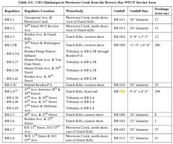
and from the same document this text and chart
The Low Level service area contains 46 regulators, of which 19 interconnected regulators discharge to the Newtown Creek during wet weather through the 13 CSOs. Of these 13 CSOs, 6 discharge to the tributary Dutch Kills (BB-004, 009, 010, 026, 040, and 042), and 6 discharge to Newtown Creek(BB-011, 012, 013, 014, 015, and 043). An additional 2-feet, 8-inches x 4-foot outfall, BB-049, is listed in the Bowery Bay WPCP SPDES permit as discharging to Dutch Kills near 21st Street, but no further information is available such as which regulator it is connected to.
lutes and dancing

– photo by Mitch Waxman
Wandering aimlessly across the pattern that underlies the streets of Long Island City, a logical course whose every obstacle is modern, one day I found myself in the Empty Corridor. Not so empty as it used to be, for the continuing diversion of traffic away from the Borden Avenue Bridge funnels vast numbers of vehicles through these streets- some of which are still clad in only their original Belgian Block cobbles.
from wikipedia
Public property
- It is generally legal to photograph or videotape anything and anyone on any public property, with some exceptions.
- Taking a photograph while on an airplane is banned in many places, and many mass transit systems prohibit taking photographs or videos while on board buses or trains or inside of stations. (It is unknown whether such prohibitions are legal, due to transit systems in the United States often being considered public places.) Photography is against Port Authority rules in New York and New Jersey’s PATH Train system. Photography and videography are also prohibited in the U.S. Capitol, in courthouses, and in government buildings housing classified information. Bringing a camera phone into one of these buildings is not permitted either.
- Photographing or videotaping a tourist attraction, whether publicly or privately owned, is generally considered legal, unless explicitly prohibited by posted signs.

– photo by Mitch Waxman
Always on the lookout for intriguing items to photograph, your humble narrator often finds himself in front of scenes such as this one, and possessed by a paradoxical mindset. On one hand, the artwork which adorns this octagonal stop sign is well wrought, and skillfully placed for maximum esthetic value. On the other, this is vandalism- and it creates a dangerous situation regarding the passage of vehicles through a now unmarked intersection.
Further, I’m often at odds with the ideation of taking photos of such displays at all.
from wikipedia
Private property
Photography may be prohibited and/or restricted within an area of property by the property owner. At the same time, a property owner generally cannot restrict the photographing of their property by individuals who are not located within the bounds of the property.
In order to film on someone else’s property, permission must be received from the owner.
Photographing of privately-owned property that is generally open to the public (i.e. retail) is permitted unless explicitly prohibited by posted signs.
Some jurisdictions have laws regarding filming while in a hospital or health care facility. Where permitted, such filming may be useful in gathering evidence in cases of abuse, neglect, or malpractice.

– photo by Mitch Waxman
Public art, even when unsigned, is still considered to be the property of the original artist. Technically speaking, I’m not allowed to “publish” this image without the express permission of the artist and despite the fact that I own the copyright on the image, I can’t transfer or sell it without permission.
Were this posting commercial in nature, in fact, a court of law could assign damages and restitution. Art commissioned and owned by “The State” on behalf of the public is a different matter, and a complicated legal ground that’s ever shifting about. Generally, if it’s owned by the U.S. government and produced before the 1970’s it’s probably in the public domain.
Usually, I just leave this sort of thing to the prolific Ms. Heather over at NY Shitty, as she’s much better at finding new and exciting street art than I and is possessed of a curatorial spirit toward her discoveries.
But this one I couldn’t stop from shooting. Click the image for the larger size, as these are very nicely drawn images.
from wikipedia
Copyright is a set of exclusive rights granted by the law of a jurisdiction to the author or creator of an original work, including the right to copy, distribute and adapt the work. Exceptions and limitations to these rights strive to balance the public interest in the wide distribution of the material produced and to encourage creativity. Exceptions include fair dealing and fair use, and such use does not require the permission of the copyright owner. All other uses require permission and copyright owners can license or permanently transfer or assign their exclusive rights to others. Copyright does not protect ideas, only their expression or fixation. In most jurisdictions, copyright arises upon fixation and does not need to be registered. Copyright protection applies for a specific period of time, after which the work is said to enter the public domain.
previous recollections

– photo by Mitch Waxman
Recently, I was obliged to meet up with a couple of guys from Williamsburg when they asked me to guide them through some of the Newtown Creek’s less well known attractions. My pithy reply was that I would be straddling the border of Brooklyn and Queens, and they should just meet me there- at the venerable Grand St. Bridge. I walked there from Astoria in record time, arriving quite a bit earlier than I had anticipated.
Luckily the morning was crisp, my coffee was hot, and the burning thermonuclear eye of god itself was shining strongly- which afforded me with a nice opportunity me to do a little shooting.
Note: I’m never sure how to describe the actual act of photography. Shoot, capture, take- all somewhat violent terms which don’t really fit the action. Sniper techniques do transfer neatly into telephoto work, exhaling while triggering the shutter and all that, but… it’s all rather soldier sounding isn’t it?
from wikipedia
Photography is the process, activity and art of creating still or moving pictures by recording radiation on a radiation-sensitive medium, such as a photographic film, or electronic image sensors. Photography uses foremost radiation in the UV, visible and near-IR spectrum.[1] For common purposes the term light is used instead of radiation. Light reflected or emitted from objects form a real image on a light sensitive area (film or plate) or a FPA pixel array sensor by means of a pin hole or lens in a device known as a camera during a timed exposure. The result on film or plate is a latent image, subsequently developed into a visual image (negative or diapositive). An image on paper base is known as a print. The result on the FPA pixel array sensor is an electrical charge at each pixel which is electronically processed and stored in a computer (raster)-image file for subsequent display or processing. Photography has many uses for business, science, manufacturing (f.i. Photolithography), art, and recreational purposes.
As far as can be ascertained, it was Sir John Herschel in a lecture before the Royal Society of London, on March 14, 1839 who made the word “photography” known to the whole world. But in an article published on February 25 of the same year in a german newspaper called the Vossische Zeitung, Johann von Maedler, a Berlin astronomer, used the word photography already. The word photography is based on the Greek φῶς (photos) “light” and γραφή (graphé) “representation by means of lines” or “drawing”, together meaning “drawing with light”

– photo by Mitch Waxman
Surreal, the waters around the Grand Street Bridge teem with that alien colour which typifies and describes the industrial hinterlands of that annihilation of innocence which is called the Newtown Creek. For an extensive description and history of this spot, a busy automotive and truck crossing in modernity, click the following for the Newtown Pentacle posting “a Grand Journey in DUGSBO”
from nyc.gov
Grand Street is a two-lane local City street in Queens and Kings Counties. Grand Street runs northeast and extends from the Brooklyn Queens Expressway in Brooklyn to Queens Boulevard in Queens. The road is known as Grand Street west of the bridge and Grand Avenue east of the bridge. The bridge is located between Gardner Avenue in Brooklyn and 47th Street in Queens. The Grand Street Bridge is a 69.2m long swing type bridge with a steel truss superstructure. The general appearance of the bridge remains the same as when it was opened in 1903. The bridge provides a channel with a horizontal clearance of 17.7m and a vertical clearance, in the closed position, of 3.0m at MHW and 4.6m at MLW. The bridge structure carries a two-lane two-way vehicular roadway with sidewalks on either side. The roadway width on the bridge is 6.0m and the sidewalks are 1.8m wide. The height restriction is 4.1m. The approach roadways are wider than the bridge roadway. For example, the width of Grand Avenue at the east approach to the bridge (near 47th Street) is 15.11m.
The first bridge on this site, opened in 1875, quickly became dilapidated due to improper maintenance. Its replacement, opened in 1890, was declared by the War Department in 1898 to be “an obstruction to navigation.” Following a thorough study, a plan was adopted in 1899 to improve the bridge and its approaches. The current bridge was opened on February 5, 1903 at a cost of $174,937.

– photo by Mitch Waxman
While pondering the atypical number of 19th century suicides which occurred here, a flock of geese happened along in this so called urban desert and distracted me from my usual morbid soliloquy. They were pecking at the manmade bulkheads, skimming for waterline plant life.
from wikipedia
The Canada Goose was one of the many species described by Linnaeus in his 18th-century work Systema Naturae. It belongs to the Branta genus of geese, which contains species with largely black plumage, distinguishing them from the grey species of the Anser genus. The specific epithet canadensis is a New Latin word meaning “from Canada”. According to the Oxford English Dictionary, the first citation for the ‘Canada Goose’ dates back to 1772. The Cackling Goose was formerly considered to be a set of subspecies of the Canada Goose.

– photo by Mitch Waxman
Nearby was this enormous creature, balancing on one foot . Unfortunately, it wasn’t disposed toward looking my way, despite my best Brooklyn exclamation of “hey, boid, overs here’s”. When a tractor trailer blew by, it suddenly exploded upward.
from wikipedia
New York dialect is predominantly characterized by the following sounds and speech patterns:
Vowels
- The low back chain shift The /ɔ/ vowel sound of words like talk, law, cross, and coffee and the often homophonous /ɔr/ in core and more are tensed and usually raised more than in General American. Labov (1966) describes this pattern as varying on a scale from [ɔ] to [ʊ]. An inglide typically accompanies higher variants giving [oə] or [ʊə]. /ɑ/ in father and /ɑr/ in car are backed, diphthongized, and sometimes rounded to [ɑə] or [ɒə]. The result is that card in New York can be similar to cod in parts of New England. In addition, a subset of words with /ɒ/ as in lot feature a lengthened and diphthongized variant, [ɑə]. This variant may appear before a word final voiced stop, /dʒ/, or /m/ (e.g., cob, cod, cog, lodge, bomb). It also occurs variably before voiced fricatives (e.g., bother), /ʃ/ (e.g., wash), and in the words on, John, and doll (Wells 1982: 514).
- The short-a split There is a class of words, with a historical short-a vowel, including plan, class, and bad, where the historical /æ/ is raised and tensed to an ingliding diphthong of the type [eə] or even [ɪə]. This class is similar to, but larger than, the BATH lexical set, in which Received Pronunciation uses the so-called broad A. Other words, such as plaque, clatter, and bat, retain a lax, low-front [æ], with the result that bad and bat have different vowels. A related (but slightly different) split has occurred in the dialect of Philadelphia. Although the lax and the tense reflexes of /æ/ are separate phonemes in these dialects, their distribution is largely predictable. See Phonemic æ-tensing in the Mid-Atlantic region for more details.
- /oʊ/ as in goat does not undergo fronting; instead, it remains [oʊ]. This groups New York with the “North” class of dialects rather than the “Midland”, in which /oʊ/ is fronted. Relatedly, /uː/ as in goose is not fronted and remains a back vowel [uː] or [ʊu]. This lack of fronting of /oʊ/ and /uː/ also distinguishes New York from nearby Philadelphia. Some speakers have a separate phoneme /ɪu/ in words such as tune, news, duke (historically a separate class). The phonemic status of this vowel is marginal. For example, Labov (1966) reports that New Yorkers may contrast [duː] do with [dɪu] dew though they may also have [dɪu] do. Still, dew is always [dɪu] and never [duː].
- Diphthongs The nucleus of the /aɪ/ diphthong is a back and sometimes rounded vowel [ɑ] or [ɒ] (right as [ɹɑɪt]) and the nucleus of the /aʊ/ diphthong is a front vowel [æ] (rout as [ɹæʊt]). The sociolinguistic evidence (Labov 1966) suggests that both of these developments are active changes. The fronted nucleus in /aʊ/ and the backed nucleus in /aɪ/ are more common among younger speakers, women, and the working and lower middle classes.
- pre-r distinctions New York accents lack most of the mergers before medial /r/ that many other modern American accents possess:
- The vowels in marry [mæri], merry [mɛri], and Mary [meri] ~ [mɛǝri] ~ [mɛri] show either a two- or three-way contrast.
- The vowels in furry /fɜri/ and hurry /hʌri/ are distinct.
- Words like orange, horrible, Florida and forest are pronounced /ɑrəndʒ/ and /fɑrəst/ with the same stressed vowel as pot, not with the same vowel as port as in much of the rest of the United States.
- Merger of /ɜr/ and /ɔɪ/: One of the stereotypes of New York speech is the use of a front-rising diphthong in words with /ɜr/ (e.g., nurse). This stereotype is popularly represented in stock phrases like “toity toid” for thirty-third. The phonetic reality of this variant is near [ɜɪ]. This variant may also appear in words with /ɔɪ/ (e.g., choice), resulting in verse and voice as homophones. The diphthongal variant for /ɜr/ is highly stigmatized. Labov’s data from the mid-1960s indicated the form was recessive then. Only two of his 51 speakers under age 20 used the form as compared with those over age 50 of whom 23 out of 30 used the form. Items with /ɔɪ/ may occur with [ɜr] (e.g., [tɜrlət] toilet), apparently as a result of hypercorrection. Younger New Yorkers (born since about 1950) are likely to use a rhotic [ɜr] in bird even if they use non-rhotic pronunciations of beard, bared, bard, board, boor, and butter.

– photo by Mitch Waxman
Turns out it’s a heron. Go figure, a heron at Newtown Creek.
from wikipedia
The herons are wading birds in the Ardeidae family. There are 64 recognised species in this family. Some are called egrets or bitterns instead of herons. Within the family, all members of the genera Botaurus and Ixobrychus are referred to as bitterns, and—including the Zigzag Heron or Zigzag Bittern—are a monophyletic group within the Ardeidae. However, egrets are not a biologically distinct group from the herons, and tend to be named differently because they are mainly white and/or have decorative plumes. Although egrets have the same build as the larger herons, they tend to be smaller.
The classification of the individual heron/egret species is fraught with difficulty, and there is still no clear consensus about the correct placement of many species into either of the two major genera, Ardea and Egretta. Similarly, the relationship of the genera in the family is not completely resolved. However, one species formerly considered to constitute a separate monotypic family Cochlearidae, the Boat-billed Heron, is now regarded as a member of the Ardeidae.
Although herons resemble birds in some other families, such as the storks, ibises and spoonbills, they differ from these in flying with their necks retracted, not outstretched. They are also one of the bird groups that have powder down.
Some members of this group nest colonially in trees; others, notably the bitterns, use reedbeds.

– photo by Mitch Waxman
That’s it for today, over the weekend I’ll be thrilling you with recent encounters your humble narrator has had with the political class who rule over New York City.
Also, please buy a copy of our book- Newtown Creek, for the vulgarly curious- here. Every copy sold contributes directly to sustaining and maintaining this- your Newtown Pentacle.
from wikipedia
Grand Street is a street in Williamsburg, Brooklyn, New York City, United States. The Grand Street (BMT Canarsie Line) subway station serves the corner of Grand Street and Bushwick Avenue. Crossing English Kills into Queens, Grand Street becomes Grand Avenue, continuing through Maspeth where it is a main shopping street, to Elmhurst. Its northern end is at Queens Boulevard. Broadway continues the thoroughfare north and west.
History
In the 19th century, before the construction of the Williamsburg Bridge, the Grand Street Ferry connected Grand Street, Brooklyn to Grand Street, Manhattan. The Grand Street Line was a streetcar line along the road.
from some point in space

– photo by Mitch Waxman
Recent travels and travails, which I’ll be describing in some detail in the coming days, have been consuming me. Antiquarian studies, which normally bring joy and excitement to one such as myself, are instead feeding a black dog nipping at my heels. The arrival of seasonally appropriate cold weather shatters the illusion I project of vigor and health, and instead reveals a weakened and tired old man whose ease of movement and comfort is shattered by lower temperatures. A huddled mass of insulating garments, what you perceive as a windblown pile of rag and filth often reveals itself to be me.
I’m all ‘effed up.
from nytimes.com
The Roswell P. Flower estate sold last week to the Borden Realty Company, a subsidiary concern of the Degnon Terminal Improvement Company, 362 lots in the sunken meadows south of Jackson Avenue, in Long Island City, and extending to Dutch Kills Creek and Newtown Creek, at prices ranging, it is said, from $1,000 to $1,500 each.
The Degnon Terminal Company has already invested from $2,500,000 to $3,000,000 in Long Island City meadows and meadows at the head of Flushing Bay, in the towns of Flushing and Newtown.
The meadows are to be filled in with the earth taken from the Belmont tunnel, and the Dutch kills Canal and Flushing Bay are to be dredged.

– photo by Mitch Waxman
Recent opportunities and accesses to certain locations normally forbidden to the general public have drawn me out from HQ, however, and that which I have witnessed is the terrible spectacular of those sky flung monoliths and hybrid pestilences which typify the City of Greater New York in these dawning years of the 21st century. Gaze in despair upon the waste meadows of Dutch Kills, from high above.
from trainsarefun.com
Just south of Sunnyside Yards is Degnon Terminal, operated by the Degnon Realty & Terminal Improvement Company. A subsidiary, Degnon Terminal Railroad Corporation operated a switching terminal. It received and delivered cars from and to connections and switched them to the various industries, also the reverse operation. This carrier’s only railroad connection was with the Montauk Cutoff of the Long Island Rail Road at Pearson Street [Hunterspoint Avenue], Long Island City. Degnon constructed its tracks about 1919, although land reclamation and grading began about 1907.

– photo by Mitch Waxman
My vantage was from within the cyclopean Degnon Terminal, a once mighty industrial center and railhead which has been transmogrified into a community college. The occasion which brought me here will be explored in later postings, but since the ennui under which your humble narrator currently suffers precludes any notion of positive thought, it was decided to just display these images for your consideration and not engage in some some long winded and depressing monolog about it.
from nydesigns.org
The NYDesigns staff know that summer’s truly over when, after two introspective weeks in a silent fructarian monastery in Appalachia, we spy the godzilla-sized, tomato-red IDCNY sign halfway through the 7-minute walk from the trains at Courthouse Square. We share the building with LaGuardia College CUNY and E. Gluck Corporation, a watch manufacturing company.
In 1908, however, the “Thousand Window Bakery,” a best practice factory showcase for the Loose-Wiles Biscuit company originally of Kansas City was the building’s sole tenant. All 10 stories of the building housed production, sales and management as well as 2500 employees in a Fabian, sun-infused proletarian paradise, complete with a lending library and a clubhouse. Trading under the name Sunshine Biscuits, the cookies were baked in the shape of Popeye, Olive, Swee’pea, Wimpy, etc. and distributed in tin boxes which are now modestly priced collectibles. Animal crackers originated here. Now a subsidiary of Keebler, Sunshine is now best known for producing the Cheez-It brand of snack crackers.
The “Thousand Window Bakery” was one piece within the larger industrial park of Degnon Terminal, the brainchild of Michael Degnon, entrepreneur and railyard contractor for the Sunnyside Yards, which abut the building’s northwestern facade. Degnon Terminal was attractive to companies including the Packard Auto Company, Ever Ready, and Chicle (of Chiclets gum) because of the ease in shipping just-manufactured goods via rail straight to distributors.The Sunnyside rail lines haven’t seen any traffic since 1989 and the industrial occupants have long moved on to more affordable real estate climes. Sunshine left in the mid ’60s.

– photo by Mitch Waxman
The water you see in the center of these photographs is the logical end of Dutch Kills, a tributary of the oft maligned Newtown Creek. The first bridge you see is the Hunter’s Point Avenue Bridge, which nears its 100th year of service to the municipality in uncommented anonymity (not if I have anything to say about that), and the large white structure is the Queens Midtown Expressway section of the Long Island Expressway which hurtles high over the empty corridor of long Island City.
Beyond is infinite Brooklyn, with the Newtown Creek Wastewater Treatment Facility just left of center in centuried Greenpoint.
from nyc.gov
Long Island City is comprised of five separate neighborhoods: Ravenswood, Astoria, Steinway, Sunnyside, and Hunter’s Point. Engine Company No. 258 is located on 47th Street in Hunter’s Point, about halfway between Newtown Creek and the Queensboro Bridge. Though someearly nineteenth-century legal documents refer to the area as Long Island Farms or Long Island City, it was not until the 1850s that the current name was widely used. Popularized by a local newspaper, the Long Island Star, when the five villages were incorporated as an independent municipality in 1870, the neighborhood was officially named. Hunter’s Point became the commercial and political center of the new city, served by the Long Island Railroad at 2nd Street, near the East River, and multiple ferries to Manhattan. The seat of Queens County moved here from Jamaica, and two years later, in 1872, the New York Supreme Court Building for Queens County (reconstructed 1904-8, a designated New York City Landmark) was built on Jackson Avenue, now called Court Square. Long Island City grew quickly and the population tripled between 1875 and 1900. Among the various houses built in the area, a fine group survives on 45th Avenue, between 21st and 23rd Streets, in the Hunter’s Point Historic District. Faced in brick, brownstone, and Tuckahoe marble, these Italianate, Second Empire,and Neo-Grec structures, were collectively known as “White Collar Row.” Hunter’s Point had nearly 18,000 residents in 1905, a number that has never been exceeded.
Queens became a borough of Greater New York in 1898 and Long Island City became theseat of the borough president, with offices in the Hackett Building (c. 1885) on Jackson Avenue until 1916. Various transit projects that proved critical to real estate development in Queens were completed during this period, including the opening of the Queensboro Bridge (1909, a designated New York City Landmark), tunnels linking Manhattan with the vast Sunnyside Yards (1910), and the beginning of regular IRT subway service (1915) to Corona, and later, Flushing. Access to the general area was greatly improved, attracting large factories and warehouses that benefited from spur lines that allowed freight cars to travel directly to the loading docks. Various examples can be found in the Degnon Terminal area, along Thomson Avenue, where the Adams Chewing Gum and Loose Wiles Sunshine Biscuit companies located in the 1910s. These improvements, however, had a downside, creating barriers that isolated Hunter’s Point from the rest of the borough, while making it easier for commuters to reach new residential districts to the east, in Sunnyside, Jackson Heights, and other neighborhoods.


