Archive for the ‘Tugboat’ Category
tremendous resolution
Thursday

– photo by Mitch Waxman
It’s all still there! Despite what the television said, the hot war between Antifa and the Boogaloos hasn’t actually burned the City away and left it looking like Dresden. Son of a gun! That’s the Helen Laraway Tug, spotted as it passed by an old fruit pier in lower Manhattan which has been converted over to a vehicle maintenance facility for the DSNY in modernity. That’s where the proverbial banana boat used to dock, that pier, and it’s the one that your grandmother would accuse new neighbors of having arrived into NYC via.
As mentioned yesterday, a long-standing resolution of mine has been to get the hell out of Queens for an afternoon and go ride on the ferries. This is the first year in more than a decade that I haven’t spent a good number of my summertime evenings riding around on boats and photographing the maritime world, so I had to do something about that before it turns cold and dark again.

– photo by Mitch Waxman
Brooklyn Bridge – still there. Lower Manhattan too.
My plan for the day was to a) spend as little as possible and b) get as far away from Queens as was feasible. The Astoria line NYC Ferry travels south along the East River. Its new north terminal stop is at 90th st. in Manhattan, then there’s Astoria, Roosevelt Island, LIC North, 34th st., Brooklyn Navy Yard, and the southern terminal stop is at Pier 11 Wall Street in lower Manhattan. From there, the Staten Island Ferry is about a ten minute walk away.
The NYC Ferry Fair was $2.75, and the Staten Island Ferry is free. That’s “A.” Staten Island accomplished “B.”

– photo by Mitch Waxman
Upon debarking from the NYC Ferry, a dredging operation being committed by the DonJon company was noticed. This is just south of Pier 11, and I can make several presumptions as to who, when, what, where, and why. Thing is that I’d just be speculating that; the EDC, in some time prior to March, decided to expand Ferry operational capabilities here at the foot of Wall Street, to please their masters in the real estate industry. Speculation, however, so don’t take that to the bank.
Tomorrow – what I saw from onboard the big orange boat.
Note: I’m writing this and several of the posts you’re going to see for the next week at the beginning of the week of Monday, September 7th. My plan is to continue doing my solo photo walks around LIC and the Newtown Creek in the dead of night as long as that’s feasible. If you continue to see regular updates here, that means everything is kosher as far as health and well being. If the blog stops updating, it means that things have gone badly for a humble narrator.
“follow” me on Twitter- @newtownpentacle
Buy a book!
“In the Shadows at Newtown Creek,” an 88 page softcover 8.5×11 magazine format photo book by Mitch Waxman, is now on sale at blurb.com for $30.
vestiges of
How many times a week can you say it’s Monday, huh?

– photo by Mitch Waxman
As described last week, my pal Val drove her Valmobile – with myself and a libertarian named Scott within it – out to a photogenic spot on the Kill Van Kull waterway which forms a busy martime shipping channel as well as the border betwixt… Staten Island… and Bayonne, New Jersey. After visiting this spot – known to my circle as “Skelson’s Office,” it was decided to make like a chicken and cross to the other side. Our path carried the Valmobile over the newly reconfigured Bayonne Bridge.
By reconfigured, I mean that the Port Authority has just finished spending multiple millions of bucks to raise the roadway from its original height in pursuit of allowing ever larger cargo ships access to the Port Elizabeth Newark complex in Newark Bay.

– photo by Mitch Waxman
In Bayonne, which is largely the unknown country for a humble narrator, we floundered around a bit but managed to find a couple of opportune spots that largely looked westwards towards the port facilities. We were becoming increasingly apprehensive about weather, which as you see from the shot above, was forming up an afternoon thunderhead of the type you expect to see in late August around these parts.
If I was a superhero, my nom de plume would be “Captain Vocabulary.” On that note, the beams of light at the left side of the shot are referred to as “crepuscular rays.” Scott the Libertarian didn’t care, which is a big part of that particular political philosophy – not caring – and he was busy trying to figure out a spot where we could buy lunch in the surrounding neighborhood on his phone while Val and I waved our cameras about.

– photo by Mitch Waxman
That’s the control tower at Newark Airport just left of center, which kind of suggests where this shot was gathered. The blue tug is part of the DonJon outfit, and it was wrestling a seemingly empty group of barges into place.
More tomorrow at this – you Newtown Pentacle.
Note: I’m writing this and several of the posts you’re going to see for the next week at the beginning of the week of Monday, August 24th. My plan is to continue doing my solo photo walks around LIC and the Newtown Creek in the dead of night as long as that’s feasible. If you continue to see regular updates here, that means everything is kosher as far as health and well being. If the blog stops updating, it means that things have gone badly for a humble narrator.
“follow” me on Twitter- @newtownpentacle
Buy a book!
“In the Shadows at Newtown Creek,” an 88 page softcover 8.5×11 magazine format photo book by Mitch Waxman, is now on sale at blurb.com for $30.
less annoying
Friday
– photo by Mitch Waxman
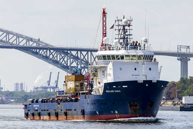
As mentioned yesterday, a recent day trip with a couple of friends found the camera being waved about at “Skelson’s Office,” a particularly photogenic spot on Staten Island’s Kill Van Kull waterfront frequented by a dearly departed photographer pal of mine. The bridge in the background is the Bayonne Bridge, which acts as a gateway to the Port Elizabeth Newark shipping complex. A significant percentile of the economy of the entire United States is focused through this tidal strait, I would offer.
Pictured is the Highland Eagle, an offshore supply vessel flagged in the UK.
– photo by Mitch Waxman
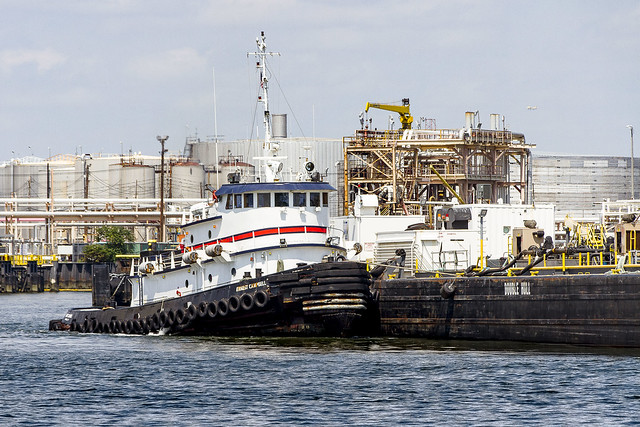
The Bayonne coastline of Kill Van Kull is all about petroleum and the various refined products derived from it.
Pictured is the Ernest Campbell, a 1969 vintage Tugboat, wrestling a fuel barge away from its dock and into the currents of Kill Van Kull. The structure behind it hosts the various hoses which the upland tank farm uses to move the product around. A bit of maritime trivia – the various hoses and fuel barges have different connectors on them to keep one product from mixing with another. The kerosene pipe doesn’t connect to the gasoline or #2 fuel oil gasket, which keeps volatile mistakes at a minimum.

– photo by Mitch Waxman
Moran Towing’s Turecamo Girls Tug was likely returning to their base at Kill Van Kull when this shot was captured. Moran Towing has the iconic NYC tugs, with the red wheelhouse and big letter “M” on them. Moran names their boats after family members, generally, but in this case the 1965 tug was acquired after a merger with another towing corporation (Turecamo Towing) back in 1998.
Back Monday with more from the waterfront.
Note: I’m writing this and several of the posts you’re going to see for the next week at the beginning of the week of Monday, August 17th. My plan is to continue doing my solo photo walks around LIC and the Newtown Creek in the dead of night as long as that’s feasible. If you continue to see regular updates here, that means everything is kosher as far as health and well being. If the blog stops updating, it means that things have gone badly for a humble narrator.
“follow” me on Twitter- @newtownpentacle
Buy a book!
“In the Shadows at Newtown Creek,” an 88 page softcover 8.5×11 magazine format photo book by Mitch Waxman, is now on sale at blurb.com for $30.
likewise inaccessible
Thursday
– photo by Mitch Waxman
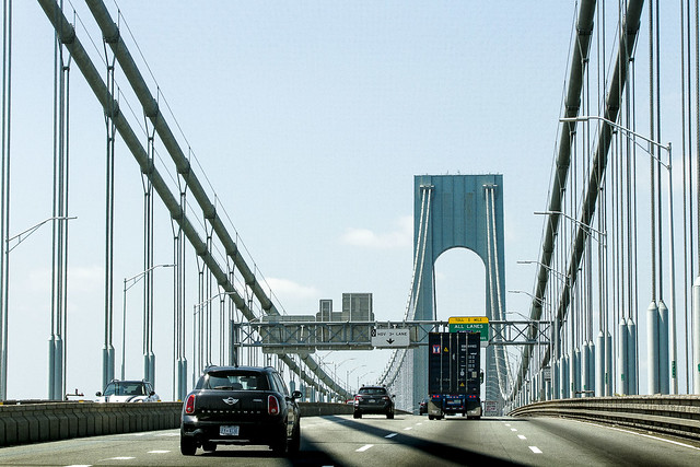
Earlier this week, one met up with his pal Val and we jumped into her shiny Valmobile with the singular intention of shooting ships. Accordingly, Val oriented the Valmobile in the direction of… Staten Island. After all these months of quarantine/pandemic walks around LIC and Newtown Creek, a humble narrator was positively squeaking with excitement as we heroically mounted the Verazzano Bridge and headed towards the Kill Van Kull waterway.
Adventure, excitement… a Jedi craves not these things, but I ain’t no Jedi.
– photo by Mitch Waxman
Our first stop was at “Skelson’s Office,” where my old and dearly departed pal John Skelson used to spend his time. This is a spot along the old and abandoned Vanderbilt Staten Island Railroad tracks which follow Kill Van Kull. KVK is often mentioned here during normal times, but for anyone not clued in – it’s a tidal strait that connects the lower harbor of New York with Newark Bay and another strait called Arthur Kill.
Kill Van Kull is the preferred approach route to the New York Container Terminal on Staten Island and the Global Marine/Port Elizabeth Newark complex in Bayonne, New Jersey for maritime shipping. For enthusiasts like my pal Val and myself, it’s “tugboat alley.”

– photo by Mitch Waxman
The show started as soon as we arrived at Skelson’s Office.
Our efforts later in the day found us over in Bayonne, and along the Hackensack and Passaic rivers. One thing that emerged during that part of the day was a sincere desire to find out more about the industrial sections of this section of New Jersey. I mentioned several times that I wished we were in a boat on the water, and that I was also anxious to find an analogue of Newtown Creek Alliance for this area to introduce me to the place.
A third person was in the Valmobile with us, my friend Scott, but he’s a Libertarian so we didn’t pay attention to anything he had to say. More tomorrow.
Note: I’m writing this and several of the posts you’re going to see for the next week at the beginning of the week of Monday, August 17th. My plan is to continue doing my solo photo walks around LIC and the Newtown Creek in the dead of night as long as that’s feasible. If you continue to see regular updates here, that means everything is kosher as far as health and well being. If the blog stops updating, it means that things have gone badly for a humble narrator.
“follow” me on Twitter- @newtownpentacle
Buy a book!
“In the Shadows at Newtown Creek,” an 88 page softcover 8.5×11 magazine format photo book by Mitch Waxman, is now on sale at blurb.com for $30.
almost unassailably
Well, flippity floppity floop, it’s Friday again.
– photo by Mitch Waxman
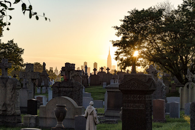
Recent endeavor found a humble narrator scuttling through the humidity thickened July atmospherics typical of Western Queens and heading towards Newtown Creek for a session of waving the camera around. Pictured above is the 1848 vintage First Calvary Cemetery in Blissville, looking westwards from Laurel Hill Blvd.
What with all of this pandemic business and the new Kosciuszcko Bridge offering a pedestrian and bike path between Greenpoint in Brooklyn and Blissville here in the Long Island City section of Queens, there’s now a lot of people milling around. For years and years, it was just me wandering around this area. It’s taking a lot of “getting used to” seeing others in my happy place.
– photo by Mitch Waxman
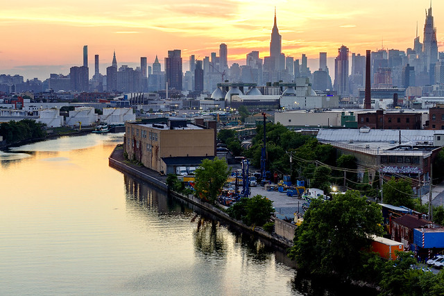
The views from the Kosciuszcko Bridge are epic, and I timed my walk to put me Center span just as the burning thermonuclear eye of God itself was descending behind Manhattan and New Jersey. This point of view is 2.1 miles from the East River, for the morbidly curious. The right side of the shot is in Queens, the left is in Brooklyn.
Newtown Creek is a tributary of the East River which extends south/eastwards 3.8 miles from its junction with the larger waterway, eventually terminating in Brooklyn’s Bushwick neighborhood. There are multiple tributaries of Newtown Creek which snake off the main stem of the waterway.
– photo by Mitch Waxman
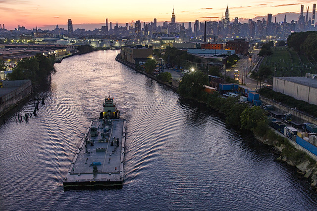
Luckily, for me, a tug and barge combination was navigating its way eastwards while I was set up and shooting. Once one fo the busiest maritime industrial waterways in these United States, Newtown Creek is still quite busy. While I was out shooting, I saw the Greenpoint Avenue Draw Bridge – roughly a mile to the west – open and close three times.
A recent meeting with the United States Army Corps of Engineers described the ideal depth of these waters as being 23 feet. The last time a proper navigational dredging of the entire Newtown Creek occurred (other than a minor channel maintenance operation performed at the behest of the NYC DEP a few years ago) was in the early 1970’s. Tug and barges, therefore, stick to the center of the channel where the water is deepest when navigating through.
Note: I’m writing this and several of the posts you’re going to see for the next week at the beginning of the week of Monday, July 27th. My plan is to continue doing my solo photo walks around LIC and the Newtown Creek in the dead of night as long as that’s feasible. If you continue to see regular updates here, that means everything is kosher as far as health and well being. If the blog stops updating, it means that things have gone badly for a humble narrator.
“follow” me on Twitter- @newtownpentacle
Buy a book!
“In the Shadows at Newtown Creek,” an 88 page softcover 8.5×11 magazine format photo book by Mitch Waxman, is now on sale at blurb.com for $30.


