watching sentinels
One more bit of Creekery.

– photo by Mitch Waxman
Even at three or four in the morning, it’s hard to find a thirty second interval on the Greenpoint Avenue Bridge during which heavy trucks or buses aren’t passing over the double bascule drawbridge and causing it to quiver and quake. Getting any sort of usable long exposure shot from up there is a matter of luck for most. Since I give it a go every time I’m walking over it at night, the law of averages states that I’m occasionally going to be able to time it right.
That’s the new Kosciuszcko Bridge in the distance, poking its head up over the industrial zone found along Railroad Avenue in LIC’s Blissville section. That enormous smokestack is all that’s left of Van Iderstine’s fat rendering operation.

– photo by Mitch Waxman
If “over yonder” means the Greenpoint, Brooklyn side of Newtown Creek, then over yonder that’s what used to be called the BP Amoco yard. It’s a distribution hub for petroleum products, and those tanks contain various flavors of refined products. It sits in part of the footprint of the old Standard Oil Sone and Fleming refinery complex which would one day become Mobil Oil. Across Apollo Street to the east was another Standard refinery operation – Locust Hill. Apollo Street is the epicenter of the Greenpoint Oil Pill discovery and remediation process.

– photo by Mitch Waxman
This shot is actually a handheld one, looking roughly westwards across Greenpoint towards Manhattan. Remember that heavy traffic I mentioned? Never, ever stops.
Back Monday with something different, at this – your Newtown Pentacle.
“follow” me on Twitter- @newtownpentacle
Come on a tour!
With Atlas Obscura – Infrastructure Creek AT NIGHT! My favorite walking tour to conduct, and in a group limited to just twelve people! October 15th, 7-9 p.m.
Click here for more information and tickets!
Buy a book!
“In the Shadows at Newtown Creek,” an 88 page softcover 8.5×11 magazine format photo book by Mitch Waxman, is now on sale at blurb.com for $30.
spiritual dread
My beloved Newtown Creek.

– photo by Mitch Waxman
These shots were gathered while I was riding on a hybrid ferry boat, which at the time was running on its electric mode. This was a novel experience, I must say. Beyond the whole environmental thing, what was fascinating about this vessel was how quiet it was, and how the deck plates weren’t vibrating with transmitted engine oscillations. Can’t tell you much about the thing, as it wasn’t my “show.”
Saying that, my “show” will be once again opening its curtains on Wednesday October 15th, with an Atlas Obscura/Airbnb “experience” offering my “Infrastructure Creek” walk to a very limited group of 12. This will be an evening/night walk, which should be pretty exciting. Link is both above and below, so please come with if you can. The same tour will be repeated on October 29th. These tours are part of how I keep a roof over my head, so any and all tickets sold essentially feed me, and fund the various technologies which allow me to bring you Newtown Pentacle five days a week and fifty two weeks a year.

– photo by Mitch Waxman
Astoria Community Board 1 will be gathering at Astoria World Manor on Astoria Blvd. tonight at 6:30. It promises to be an interesting meeting. The Transportation Alternatives organization (Bicycle people) will be offering a presentation pushing for their latest advocacy position which asks the City to create a protected bike lane on Crescent Street connecting the Triborough and Queensboro Bridges. This is sure to be the subject of much conversation and gnashing of teeth in the coming months here in the ancient village, so… Additionally, there is a proposal to develop two currently industrially zoned properties on the Ditmars side of the neighborhood on 45th and 46th street into largish apartment houses.
Discussion of the latter has obsessed the frequent commenters found at Facebook’s Astoria discussion group for the last week. That particular cadre of opinion offerers seem to be composed largely of people who moved out of Astoria in the 1980’s that offer an overly sentimental picture of the “good old days” which has little resemblance to reality. For instance, somebody who is in their mid 60’s in 2019 that says “you could leave your doors unlocked back then” is referring to the late 1970’s in NYC. That’s the midst of an era when you not only triple locked your door, you also installed iron bars on both first AND second story windows.

– photo by Mitch Waxman
That aphorism about leaving your door open is something I’ve encountered my entire life. My maternal grandparents offered it when referring to living in the “Shtetl” or Lower East Side of Manhattan during the 1920’s when they first got here. My mom and dad also repeated the refrain when referring to East New York’s Brownsville or Brooklyn’s Borough Park where they respectively grew up (the Waxman family’s ancestral property holdings are now a part of the Maimonides Hospital parking garage). You heard this in the neighborhoods which I grew up in, and the saying was always tinged with a certain amount of racism, with the underlying implication that things were better during a more segregated era (red lining was a practice in the real estate world which only allowed certain ethnicities to live in certain areas. It’s part of the “how and why” which NYC’s “ethnic” enclaves were formed by – African American Bed Stuy and Bushwick, Hispanic North Brooklyn, Jewish Midwood and Crown Heights, Italian Bensonhurst and so on).
Back tomorrow with something else. See you tonight at CB1 if you want to come watch the show. Me, I wish I was going to be on a boat tonight during the storm, electric or not. I spend too much of my life in meetings.
“follow” me on Twitter- @newtownpentacle
Come on a tour!
With Atlas Obscura – Infrastructure Creek AT NIGHT! My favorite walking tour to conduct, and in a group limited to just twelve people! October 15th, 7-9 p.m.
Click here for more information and tickets!
Buy a book!
“In the Shadows at Newtown Creek,” an 88 page softcover 8.5×11 magazine format photo book by Mitch Waxman, is now on sale at blurb.com for $30.
calmed himself
What if every day was your day of Atonement?

– photo by Mitch Waxman
Sorry for being late today, my efforts of the last few weeks have caught up with me in terms of fatigue, and truth be told I’ve been up late the last couple of days binge watching the “Apocalypse” season of American Horror Story. Today is Yom Kippur, which means that my blogging will send me to hell, but I’ll just add that to my list of things to atone for at some future date.
That’s the DonJon tug Sarah Ann, having just left the Newtown Creek and towing a couple of barges of recyclable metals. The building with the four smokestacks in the background is the one you saw explode during Hurricane Sandy, and it’s a ConEd substation that steps down the high current electricity entering the City to the more usable frequencies delivered to homes and businesses here in the Shining City.
“follow” me on Twitter- @newtownpentacle
Buy a book!
“In the Shadows at Newtown Creek,” an 88 page softcover 8.5×11 magazine format photo book by Mitch Waxman, is now on sale at blurb.com for $30.
chiseled above
USCG Katherine Walker on the East River.

– photo by Mitch Waxman
Recent endeavor found a humble narrator onboard a novel hybrid ferry boat, on the East River, while the United Nations was in session a couple of weeks back. The boat I was on was running under electric power, which is a game changer as far as noise and vibration, but since I was onboard the thing I didn’t get any shots of it. What I did get, however, were shots of a relatively new (by Coast Guard standard) bit of our National kit. Launched in 1996, that’s the USCGC Katherine Walker (WLM-552).
A Keeper Class Buoy Tender, the boat is 118 feet long, powered by two CAT 3508 TA Diesel engines, and its propulsion is provided by Ulstein/Rolls Royce 360 degree steerable Z-Drives plus a 600 HP Electric Bow Thruster. Her homeport is Bayonne New Jersey. The vessel is named for a former and quite heroic keeper of the Robbins Reef lighthouse, which is found at the intersection of the Hudson River and Staten Island’s Kill Van Kull (Constables Hook), Katherine Walker.

– photo by Mitch Waxman
“The Keeper of the Robbins Reef Light” carries a crew of 24 and sports a crane which is rated to ten tons. She can do light icebreaking duty, but after encountering any pack ice over 35mm thick, they call in a purpose built icebreaker. Coast Guard ship hull colors indicate their missions – Black hull – aids to navigation, White hull – maritime law enforcement and other safety-at-sea missions, Red hull – icebreaking. All vessels under 65 feet in length are classified as “boats” and operate near shore and inland waterways, and are usually painted “Coast Guard Orange.”
Using one rubric (which is fairly colloquial and elastic) to decide “what’s a ship and what’s a boat,” the USCG classifies the Walker as a ship due to being over 65 feet and because of that crane, it can indeed launch a boat. On the Harbor, the saying goes “the difference between a ship and a boat is that a ship can launch a boat, but a boat can’t launch a ship.” If the Coast Guard – a well armed branch of the United States military – tells you that something is a ship, however, you’d be foolish to argue with them. Only idiots argue with people armed with high caliber weaponry.

– photo by Mitch Waxman
During the United Nations summit in Manhattan, there were Coast Guard ships on duty in the East River and just off the southern shoreline of Roosevelt Island all week. Earlier in the week I had spotted the CGC 108 Thunder Bay in this spot for instance. I have to imagine they were participating in Homeland Security duties for the UN events, but that’s strictly a presumption on my part. Can’t imagine they were fishing.
Katherine Walker, whom the boat is named for, was a keeper of the Robbins Reef light, as mentioned. Mrs. Walker was the light keeper for thirty years, following the death of her husband, and raised her family on the tiny spit of land which hosts the light. Check out this wikipedia page for more on her biography and heroic story. Apparently, a statue of her will be erected on the coastline of Staten Island nearby the St. George landing of the Staten Island Ferry in the near future.
“follow” me on Twitter- @newtownpentacle
Buy a book!
“In the Shadows at Newtown Creek,” an 88 page softcover 8.5×11 magazine format photo book by Mitch Waxman, is now on sale at blurb.com for $30.
was invariable
DUPBO, in LIC.

– photo by Mitch Waxman
Down Under the Pulaski Bridge Onramp, or DUPBO in Long Island City, is pictured above. Recent endeavor found one wandering around this area just after sunset about a week ago, and one decided to get busy with the camera.
The Pulaski Bridge was built by the NYC DOT as a replacement to the older Vernon Avenue Bridge which was found about a block or so to the west. The old bridge connected LIC’s Vernon Blvd. with Greenpoint’s Manhattan Avenue, and there was a streetcar or trolley service which connected the two shorelines of Newtown Creek. The former Orchard Street (bet Greenpoint Avenue and the Creek) in Brooklyn was renamed “Manhattan Avenue” about 1915 (I believe, and that’s from memory so don’t trust me on that), as the LIC side offered proximity to the brand new IRT Flushing line (the 7) subway. The trolley stop in LIC, where the trolley came to rest, is the NYC Parks Dept.’s “Vernon Mall” today. Back then, you named streets for where they were going, today you give parks meaningless names which obfuscate the past, but that’s why Greenpoint’s Orchard Street is Manhattan Avenue today.

– photo by Mitch Waxman
The derelict shoreline of LIC in DUPBO between the bridge and the Vernon street end is occupied and exploited by a colony of squatter boats these days. A hundred years ago, you would have been looking at a fleet of small tugs owned by the Newtown Creek Towing Company, whose HQ was found next door to an Ulmer Brewery Tap room on Vernon beneath the old bridge. Back then, modern day 54th and 53rd avenues were part of the LIRR Pigeon Street rail yard, which adjoined the Hunters Point Yard on the north and had tracks feeding into the Jack Frost sugar factory on the East River. The squatter boats are all blurry looking because they were rolling around on the wake of a tugboat and barge combo which had just navigated past.
The large structure on the Greenpoint side is the former Chelsea Fiber and Jute Mill at the end of Manhattan Avenue, which is known to modernity as the Greenpoint Manufacturing and Design Center – or GMDC.

– photo by Mitch Waxman
As part of the post WW2 citywide expansion of arterial roadways, drawn up by and overseen by Robert Moses, the Pulaski Bridge was designed as a high draught drawbridge which would span the Newtown Creek and magnify the amount of traffic flow between the two boroughs. Both 11th street in LIC and what would come to be called McGuinness Blvd. in Greenpoint were widened to accommodate this extra traffic. From DUPBO, you may notice that the Pulaski sports what appears to be an unfinished traffic ramp which arcs off of the eastern or Queens bound side. I’ve never been able to confirm it definitively, but the general presumption I hold is that Moses and his crew once intended to connect the Pulaski’s “flow” with the Long Island Expressway.
A bascule drawbridge of paralell counterweight design and driven by electrical motors, construction of the Pulaski Bridge was overseen by the New York City Commissioner of Public Works – Frederick Zurmuhlen – and the general contractor employed in building it was the Horn Construction Company, with steel and expertise supplied by Bethlehem Steel. It opened in September of 1954 at a cost of $9,664,446.25 – and a reconstruction of the bridge in 1994 cost $40 million. It carries five lanes of vehicular traffic, as well as dedicated (and now separated) bicycle and pedestrian lanes, and it’s a primary crossing between north Brooklyn and western Queens.

– photo by Mitch Waxman
Looking eastwards along Newtown Creek, a tug and barge passed through this thirty second exposure, causing a colorful light show to appear on my camera’s sensor. I’m fascinated by this sort of time capture, incidentally. The normal procedure for photographically capturing the passage of time is to record video, of course, or even to fire off a burst of shots. One of the things that’s emerged during all of this night photo long exposure work I’ve been doing for awhile now is that I can reveal traffic patterns, the passage of normally invisible critters in the water, even the invisible currents of air if I set the camera up correctly. You can see the pathways of fish in the water, rendered out by the reflective streaks coming off of their scales, for instance.
If I was sure that I wouldn’t blow up Brooklyn or Queens (or the Buckeye Pipeline), I’d love to throw a block of magnesium into the water and photograph it as it sank and burned – illuminating the bed of the creek. Who can guess, all there is, that might be swimming around down there? Subaqueous features, sunken boats, Jimmy Hoffa?

– photo by Mitch Waxman
That’s the staircase leading up to the LIC side of the pedestrian walkway atop the Pulaski Bridge. One advises all not to hold onto the side rails unless they have to, as the Pulaski’s rafters are full of pigeons and the entire bridge is covered in layers of guano.
The lady on the bicycle annoyed me, incidentally. Seeing me standing there with a camera and tripod setup, she first stopped her bike literally two feet away and in front of me for an interval of playing with her phone. I gently asked “excuse me, miss, can I ask you to just move forward two feet so as you’re not in my shot?” to which she silently shot me back a look of annoyance and then rolled further into the shot and right in front of the stairs. So enthralled with her glowing piece of telecommunicative glass that bodily movements all but ceased, she appears in the shot above as a semi transparent statue. There’s a metaphor in there somewhere, but I wouldn’t want to trigger the “waiting to be offended” or “overly sensitive” millennial crowd.
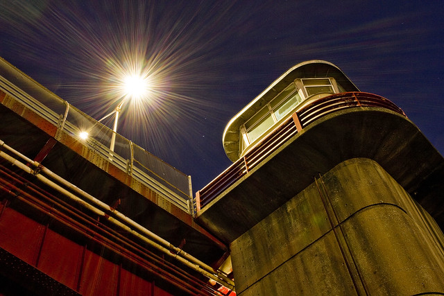
– photo by Mitch Waxman
Looking upwards at the control tower of the Pulaski Bridge from the waters edge, which is what you’re seeing. That’s where the various knobs, dials, buttons, and levers that open and close the thing are found.
These shots were gathered using my “minimal” carry setup (2 light lenses, cable release, air blower, couple of lens cloths, and that Ultrapod camera support gizmo), and I used the cheapo Canon “pancake” 24mm lens which I’ve mentioned in the past for all of them. For a variety of reasons, it doesn’t always work for me to grab the whole kit and kaboodle on my way out of HQ, and I’m also trying to carry a bit less around with me than I usually do at the moment in general. Also, not having zoom lenses and being “mission specific” forces me to think more about the “where” of my shots and there’s also the whole “be intentional” thing.
Also, lest I forget, “Pulaski Bridge” – Casimir Pulaski was a Polish military officer who joined General Washington’s Continental Army of the 13 colonies in order to assist in their war of rebellion against the Hanoverian Throne of England during the Revolutionary War. Google him, interesting person, and a Polish National Hero.
I have to don my monkey suit tonight and head off to the City for a party with the fancy folks on the Hudson side of things. I’ll be carrying the minimum kit again, so let’s see what I can get.
“follow” me on Twitter- @newtownpentacle
Buy a book!
“In the Shadows at Newtown Creek,” an 88 page softcover 8.5×11 magazine format photo book by Mitch Waxman, is now on sale at blurb.com for $30.


