last stages
The modern day East River in today’s post, which bums me out.

– photo by Mitch Waxman
One such as myself once absolutely loved the idea of riding the East River Ferry. As a matter of fact, I seem to enjoy all ferry rides, presuming that the deck is accessible and amenable to photographic pursuits. These days, the actual experience of doing so brings on depressive episodes. One of the problems with the “historian” point of view is that you tend to realize that whatever rises must also fall, and that bills must ultimately be paid. That is why we all toil and labor, to service debts, and the City of New York is currently racking up a hell of a tab.
Recently, the Alice Oldendorf bulk cargo ship was observed at work, making a delivery to a concrete plant at the Brooklyn Navy Yard as I rode the aforementioned ferry.

– photo by Mitch Waxman
The ship hosts a series of cranes and conveyors which unload her holds, producing the cyclopean mounds of sand and gravel witnessed above. It’s nice to know that at least some part of ancient Williamsburg still hosts a working waterfront, or at least a working waterfront that is engaged in the production of something other than artisanal pickles.
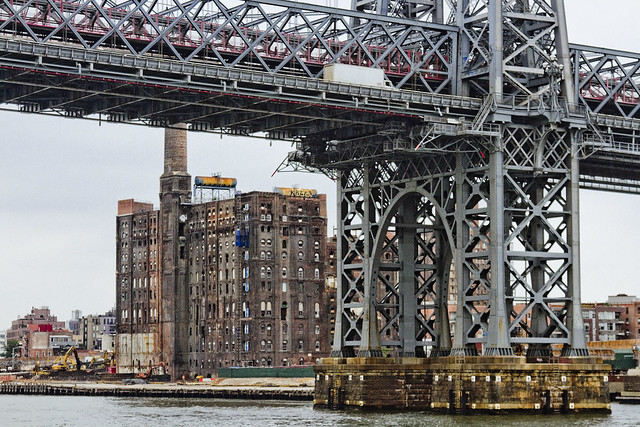
– photo by Mitch Waxman
One cannot help but drop his jaw whenever the former Havemeyer or Domino Sugar plant site comes into view. It is being redeveloped as a residential structure – more luxury condos for the children of the rich to dwell within. The question of what will happen to these structures when NYC slides backwards into an era of degeneracy and decay is one few ask.
Any historian will tell you that it’s a cyclical thing here in the megalopolis, one that flips back and forth on a roughly forty year cycle which can be directly correlated to rates of crime, and that the City’s current upswing began in the late 1990’s – reversing a decline process that started shortly after the Second World War.
Rich people tend to move away from the City center when things get hairy. The rest of us are kind of stuck here.

– photo by Mitch Waxman
Williamsburg is officially lost as a point of interest for me. Bland boxes of steel and glass will extend all along the East River soon enough, stretching from the former industrial heartland once called “America’s Workshop” in Long Island City all the way through the Gold Coast of North Brooklyn to the Williamsburg Bridge. Criminals are already beginning to focus their attentions on this area, just as they did in the age of industry. Why? Because predators go where the prey is.
It’s cliché to even comment on it anymore, one realizes.

– photo by Mitch Waxman
Scenes long familiar, lost. The wilderness of the oligarchs is upon us, and deep in the woods – wolves howl to celebrate and delight. The nobles will be safe in their keeps, but the peasants – we’re on our own.
“follow” me on Twitter- @newtownpentacle
Upcoming Tours –
August 2nd, 2015
The Insalubrious Valley of the Newtown Creek – Bushwick & Mapeth Walking Tour
with Newtown Creek Alliance, click here for details and tickets.
August 8th, 2015
13 Steps Around Dutch Kills – LIC Walking Tour
with Atlas Obscura, click here for details and tickets.
As detailed in this recent post, my camera was destroyed in an accident.
For those of you who have offered donations to pay for its replacement, the “Donate” button below will take you to paypal. Any contributions to the camera fund will be greatly appreciated, and rewarded when money isn’t quite as tight as it is at the moment.

past imagining
Wandering, wandering.

– photo by Mitch Waxman
Last week, a brief interval allowed me to escape from HQ, where a kitchen renovation has been underway for the last couple of weeks. My landlord, distressed by my reports of rodentine occupation in the so called “wet wall” found behind the 1970’s era cabinetry affixed to it, sent in the Croatians. Said Croatians have been doing a brilliant job, and are nearing completion of the project after two weeks of work (which is bit of a miracle itself here in Astoria), but I’ve been stuck here keeping an eye of things and ensuring that Zuzu the dog doesn’t wander into a tile saw or something.
Luckily, Our Lady of the Pentacle invoked a “work from home day” last week, allowing me the freedom to go on one of those ridiculously long walks across Queens for which I am sort of known. This time around, my path wasn’t towards the East River, nor Newtown Creek – instead, I headed east along Northern Blvd.

– photo by Mitch Waxman
The first thing which caught my eye was, as always, something Robert Moses left behind – the Brooklyn Queens Expressway. This is literally the “Northern Blvd. exit” by the way, which empties the highway onto the local streets in a confusing series of curved and badly marked lanes. As with all things Moses, “pedestrian friendly” is at best an afterthought. The BQE does serve a purpose for me, however, as a geographic reference point.
It’s easy to know which community of Western Queens you’re moving through when on the neighborhood’s “main drag.” You have no doubt about whether it’s Jackson Heights or Woodside when you’re on Roosevelt Avenue, for instance. Same thing with Sunnyside, Woodside, or LIC. There’s a distinct “feel” to these neighborhoods.

– photo by Mitch Waxman
Northern Boulevard, however, was built as a high volume road for automobiles. Most of what you’ll find along its length, from its transmogrification at 31st street from Jackson Avenue to Northern Boulevard all the way to its titular end of pedestrian friendliness at 114th street in Corona (and yes, I know route 25a continues all the way to Suffolk County) are automobile related businesses and chain store restaurants. Northern gets a bit more residential when you get out east into the 80’s, 90’s, and so on but it’s still pretty automobile focused. We’ll talk about that in subsequent posts that spawn out of this particular walk.
The funny thing is, of course, that a few phone calls were made to friends who grew up in Queens to double check my impressions of “where I was” while developing this set of shots. You can’t trust the real estate people, who will try to describe parts of East New York as Williamsburg if you let them.
As I said to Hank the Elevator Guy – “so if I’m on 78th and Northern…” There was some debate amongst my Queens natives on that one, incidentally, as to whether that particular area counts as Jackson Heights or Elmhurst. Consensus was achieved when several parties said “it depends on which side of Northern you’re on.”

– photo by Mitch Waxman
The fellow pictured above, who made the absolutely terrible decision to stand on the off ramp of the BQE in what is definitively Woodside (62nd and Northern), bore a bit of signage adjuring passing motorists to toss him a few handfuls of loose change. A sign of the times, this fellow actually is. Emblematic of the current Mayoral admistration’s anitipathy towards the enforcement of “quality of life” regulations which have distinguished our municipal experience over the last twenty years. I’m sure he will be replaced shortly by some guy with a squeegee and a bottle of windex. I’d vote for the squeegee guy over our current First Citizen in a heartbeat. I’d also vote for a parakeet just to see the First Citizen sent packing back to Park Slope.
This walk, an escape from the domestic construction project mentioned at the top of the post, was a bit mad btw. One emulated the proverbial “bat out of hell” and covered quite a bit of ground. Starting at Woodside Avenue and Northern Blvd., I walked east along Northern to 114th and then headed Northwest along Ditmars into East Elmhurst and then southwest back into Astoria.
Many interesting things were observed, which will be offered and described in subsequent posts at this – your Newtown Pentacle.
“follow” me on Twitter- @newtownpentacle
Upcoming Tours –
July 26th, 2015
Modern Corridor – LIC, Queens Walking Tour
with Brooklyn Brainery, click here for details and tickets.
As detailed in this recent post, my camera was destroyed in an accident.
For those of you who have offered donations to pay for its replacement, the “Donate” button below will take you to paypal. Any contributions to the camera fund will be greatly appreciated, and rewarded when money isn’t quite as tight as it is at the moment.
which swelled
Random sightings in Astoria.

– photo by Mitch Waxman
The other day, whilst waiting for the bagel shop guy to assemble a sandwich for my consumption, this pile of cigarette refuse was observed. One was impressed not just by the quantity – this has to represent around $75-80 worth of coffin nails as currently priced in NYC – but by the relative tidiness and self contained nature of the refuse. The “Vision Zero” branding on the muni meter receipt just brought it home for one such as myself.

– photo by Mitch Waxman
Over on Astoria’s Broadway, nearby Crescent Street, one of those Chinese owned dollar stores had a display of plastic flowers arrayed upon the pavement. Other offerings included off brand backpacks and those wire shopping carts which we all use for transporting bags of laundry to and fro, but the patent artificiality of the flowers transfixed me. It was actually a bit of a challenge to capture how truly saturated their colors were.

– photo by Mitch Waxman
Near Astoria Boulevard’s intersection with 21st street, this pentagram graffiti was found on the back door to a fairly ancient commercial building. When I spotted it, a loud exhortation bubbled out of me and “yeah, Satan!” was uttered. This caused no end of concern to the old Greek lady sitting on her porch across the street. Accordingly, one scuttled away and brisk perambulation carried me in a generally northern direction.
I’ve been chased through the neighborhood by a group of angry Greek women before, and do not intend on suffering through that sort of thing again.
“follow” me on Twitter- @newtownpentacle
Upcoming Tours –
July 26th, 2015
Modern Corridor – LIC, Queens Walking Tour
with Brooklyn Brainery, click here for details and tickets.
As detailed in this recent post, my camera was destroyed in an accident.
For those of you who have offered donations to pay for its replacement, the “Donate” button below will take you to paypal. Any contributions to the camera fund will be greatly appreciated, and rewarded when money isn’t quite as tight as it is at the moment.
four winds
New York Harbor, in today’s post.

– photo by Mitch Waxman
Sunday last was the Waterfront Alliance’s “City of Water Day” and your humble narrator conducted a free Newtown Creek boat tour for the festival. My tour was one of several that emanated from Governors Island, but “City of Water Day” is a citywide event and there were all kinds of interesting diversions happening in every Borough. Governors Island is a bit of a pain to get to, but luckily, after concluding my duties – an East River Ferry was just about to exit the island and then follow it’s normally scheduled itinerary, which includes a stop in LIC at Hunters Point. Deciding to “get out of dodge” and head home, and possessed of a serious desire to not get on the Subway, the ferry seemed like an ideal option.
One purchased a ticket and hopped onboard, brandished the camera, and waved it about as the boat headed North along the East River.

– photo by Mitch Waxman
Along the way, a United States Coast Guard Cutter was spotted. It’s decidedly irregular to see a white hulled Coast Guard vessel in this part of NY Harbor (white hulls are generally assigned to ocean going vessels in the Coast Guard). You’ll regularly see black hulls during winter months (ice breakers) and orange hulls do harbor security work all year long so they’re commonly observed.
One suspects that the Cutter was in the inner harbor because the President happened to be in NYC on “City of Water Day,” and they were performing some sort of security job but that’s a guess.

– photo by Mitch Waxman
That’s the CGC Ridley (WPB 87328), an 87-foot Coastal Patrol Boat Marine Protector Class vessel. She’s based in Long Island Sound, and everything you could possibly want to know about her can be found at this page at uscg.mil.

– photo by Mitch Waxman
The East River Ferry continued along its normal route, offering the usual fantastic views which have gained it a dedicated clientele amongst the hordes of tourists which populate it on weekends. Offered above is a shot of the Freedom Tower rising behind Moisef’s Manhattan Bridge, as observed from onboard.
“follow” me on Twitter- @newtownpentacle
Upcoming Tours –
July 26th, 2015
Modern Corridor – LIC, Queens Walking Tour
with Brooklyn Brainery, click here for details and tickets.
As detailed in this recent post, my camera was destroyed in an accident.
For those of you who have offered donations to pay for its replacement, the “Donate” button below will take you to paypal. Any contributions to the camera fund will be greatly appreciated, and rewarded when money isn’t quite as tight as it is at the moment.
portal guardians
Hatches abound in the Newtown Pentacle.

– photo by Mitch Waxman
One is possessed by a certain and somewhat odd fetish for “access covers” – or as they are colloquially known and popularly referred to by the local gentry – “manhole covers.”
Often, these iron discs will be the oldest thing present on any given street, due to their durability and the difficulty one encounters when attempting to replace one. According to several Federal Highway and Street design manuals which I’ve suffered through – guidelines state that it is preferential to replace one of these hatch covers only with an exact copy issued by the original manufacturer.
That’s probably why you’ll notice the Citizens Water Supply Company of Newtown’s hatches sprinkled around the neighborhoods of the Newtown Pentacle.

– photo by Mitch Waxman
About a block from the 108th Precinct’s HQ in LIC, sharp eyes will notice this 1874 vintage (independent municipality of) Long Island City sewer cap adorning the pavement.
Nothing else which has survived gentrification on this particular block dates back to anything earlier than 1900 or so, which makes this discus a genuine artifact of another age and a somewhat prehistoric culture.

– photo by Mitch Waxman
A few blocks away, on Second Street in LIC, there used to be an iconic power plant that (positively) electrified the Long Island Railroad. The power plant is gone, transmogrified by the Real Estate Industrial Complex into yet another bland residential building sheathed in mirror glass.
The rectangular LIRR access cover remains, nevertheless. This chunk of iron likely dates back to the late 1890’s, an educated based on logo usage and operational era.

– photo by Mitch Waxman
Over on Queens Blvd., in the Sunnyside area, you might notice these IRT branded storm drain covers. They are found on the roadway parking lots which underlie the massive concrete acqueduct which carries the Subway tracks high above.
These access covers are a non standard size, btw, only around 16-18 inches across. They carry the sort of typography one would expect from the house of Moses at the TBTA, and I suspect that they might have installed when Queens Blvd. was widened to its current footprint back in the 1930’s (may have been 40’s but I think it was the post Triborough Bridge era in the late 30’s. Don’t trust me on this one, I’m pulling this from memory rather than proper fact checking).

– photo by Mitch Waxman
Once upon a time, there was just one phone company. A monolith corporation which enjoyed a special status in NYC, the populace hereabouts called it “Ma Bell.” One of the interesting bits of history about which these access caps can inform the observer concerns corporate America.
You’ll see “NYCTEL” and “Bell System” as well as “NYNEX” and “Verizon” sprinkled around here and there, and all speak to the roll out of telephonic infrastructure across the megalopolis, and the evolution of the telecommunications industry.

– photo by Mitch Waxman
Speaking of wires, Consolidated Edison caps are probably the most numerous hatch covers encountered. They are larger than most of the other ones, and are sometimes several feet in diameter.
My understanding is that the electric people have been retrofitting their access pipes in recent years with plastic undercaps, whose purpose is to keep salt laden melt water from winter snowfalls from infiltrating down into and degrading the electrical equipment found within. The hidden barrier also serves to vouchsafe against the manhole cover becoming electrified.

– photo by Mitch Waxman
Over in East Elmhurst, this gorgeous hatch was recently encountered along Ditmars Blvd. in the 80’s. It belongs, or belonged, to the Brooklyn Union Gas Company – another monolithic organization which enjoyed – like the Bell System – a special monopoly in NYC.
These mega corporations operated under the aegis of a “Public Utility” designation, which meant that in return for exclusive access to the NYC market they would agree to charging politically regulated rates and perform tasks in concert with municipal officialdom.

– photo by Mitch Waxman
The typography on this hatch is particularly pleasing, to my eye, at least.

– photo by Mitch Waxman
Also in East Elhurmst, around a block or two from LaGuardia Airport, this manhole cover was encountered. Signage nearby adjures that a buried gas line is in the ground, which might offer some clue as to the occupation of the hatch, but the “ACQ” screed embossed in the iron is somewhat puzzling.
Any ideas as to its meaning, Lords and Ladies?
“follow” me on Twitter- @newtownpentacle
Upcoming Tours –
July 26th, 2015
Modern Corridor – LIC, Queens Walking Tour
with Brooklyn Brainery, click here for details and tickets.
As detailed in this recent post, my camera was destroyed in an accident.
For those of you who have offered donations to pay for its replacement, the “Donate” button below will take you to paypal. Any contributions to the camera fund will be greatly appreciated, and rewarded when money isn’t quite as tight as it is at the moment.


