delvings into
Adjusting to the frozen realities of our time.

– photo by Mitch Waxman
As a housebound invalid, which is what these frigid temperatures reduce one such as myself to, it has been a bit of trial accepting the simple fact that the burning thermonuclear eye of god itself will never again shine down upon and warm the good land of Queens. One can really get a sense of why the events which would signal the oncoming Viking apocalypse (Ragnarok) were called the “Fimbulvetr” – which translates as “awful, great winter” – after the last couple of weeks. Eschatology notwithstanding, a humble narrator wishes that something – anything – would happen, even an oncoming storm of vengeful Valkyrie, just to break the monotony of the “Frozone.”

– photo by Mitch Waxman
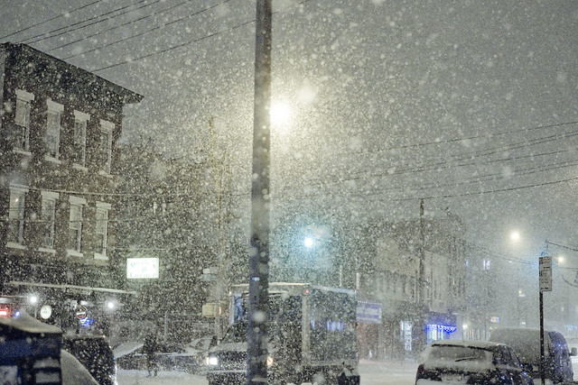
At this stage, it seems that I’ve watched everything which Netflix offers. I can recommend “Lilyhammer” without reservation, and I’ve finally caught up on “Sherlock” and can understand what everyone has been going on about. I’m rereading David McCollugh’s “The Great Bridge” and endeavoring to finally slog through the final chapters of “Gotham” by Mike Wallace and Edwin G. Burrows. Also, planning for this years series of walking tours is underway.
– photo by Mitch Waxman
I’ll be doing an event at Brooklyn Brainery in February, which will be discussed in a post later this week, and preparation for this will occupy a bit of my time, but like my little dog Zuzu – I’m bouncing off the four walls right now. I should have become a slave to Opium at some point in the past, so as to pass through intervals in the frozone in a cloud of nepenthe.
“follow” me on Twitter- @newtownpentacle
leading corridor
What’s good for the goose is good for the gander.

– photo by Mitch Waxman
As mentioned in posts last week, a couple of trips to coastal Brooklyn popped onto my schedule. In the case of today’s post, I was in South Brooklyn at the angle found twixt Red Hook and Cobble Hill, and crossing the street beneath the extremely drippy Gowanus Expressway.
from wikipedia
After the Verrazano Narrows Bridge, I-278 continues into Brooklyn on the Gowanus Expressway. Immediately after the bridge, the freeway comes to an eastbound exit and westbound entrance for the Belt Parkway. After this, a full interchange serves 92nd Street at which point I-278 becomes a single-level six-lane freeway. Along this road, one of the eastbound lanes serves as a high-occupancy vehicle lane. The Gowanus Expressway continues northeast into urban residential neighborhoods and reaches an eastbound interchange at Fort Hamilton Parkway and a westbound interchange at 86th Street. Turning more to the north, I-278 comes to a partial interchange at 65th Street, with an exit eastbound and entrance westbound. The road curves northwest at this point and comes to a directional interchange providing access to 3rd Avenue and the Belt Parkway.

– photo by Mitch Waxman
A confession, seldom do I actually pay attention to the minute details when photographing an area with which I’m not overly familiar. Instead, I go for the big shot, and use my lens at its widest angles. In the street, I have a lot to worry about – traffic, criminal underclasses and malign manifestations of the street culture, and so on. Often, when I’m at my desk and examining the shot qualitatively (focus and exposure rather than composition and esthetics etc.), something will jump out at me. Notice the blue van, which I didn’t until I was back at HQ.
from nyc.gov
…standing on a street, walkway of a bridge, sidewalk, or other pedestrian passageway while using a handheld device and not otherwise asserting exclusive use by any means, including physical or verbal, is not activity that requires a permit.

– photo by Mitch Waxman
So, there I stood, dirty black raincoat flapping about in the slipstream of truck and traffic and waving the camera about during a red light interval. Obviously, this registered in the mind of the driver of the blue van as suspicious activity, and he began to photograph me right back. The panopticon at work, lords and ladies, he saw something. Wonder if he said something?
from securetransit.org
Whether you’re following your regular commute route or on your way to a movie or meet up with friends, public transit is a key part of your day. You know public transit, and no one can spot something suspicious or out of place better than you.

– photo by Mitch Waxman
The 1984 scenario offered by Orwell has only come partially true in 2014. The State is indeed watching, and listening. Unfortunately, its usually “Little Brother” (as Cory Doctorow coined it) who is watching. This is all good though, as what is good for the goose is literally good for the gander, and the Brooklyn way is to keep an eye on the neighborhood. On this day, under the Gowanus Expressway, there were at least two surveillance devices active and pointing at each other. Mine and his. Mine was bigger.
from wikipedia
Big Brother is a fictional character in George Orwell’s novel Nineteen Eighty-Four. He is the enigmatic dictator of Oceania, a totalitarian state taken to its utmost logical consequence – where the ruling Party wields total power for its own sake over the inhabitants.
In the society that Orwell describes, everyone is under complete surveillance by the authorities, mainly by telescreens. The people are constantly reminded of this by the phrase “Big Brother is watching you”, which is the core “truth” of the propaganda system in this state.
Since the publication of Nineteen Eighty-Four, the term “Big Brother” has entered the lexicon as a synonym for abuse of government power, particularly in respect to civil liberties, often specifically related to mass surveillance.
“follow” me on Twitter- @newtownpentacle
constantly feeling
A walkabout in Red Hook, by the Gowanus.

– photo by Mitch Waxman
An assignment carried me out to the ancient harbor of South Brooklyn, Red Hook. After my business was concluded, a walkabout was conducted. Nothing “formal,” as I wasn’t looking for anything in particular, just poking around a bit while walking back to the train. Can’t have my beloved Creek think I’m cheating on her, especially not with her sister of the superfund.
– photo by Mitch Waxman
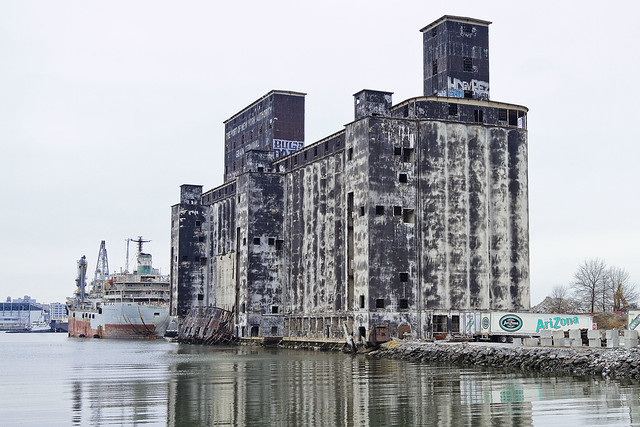
The Gowanus Canal, of which I know little. That’s something I say all the time, and I’m being a bit disingenuous. By the standards of the average person, I know a lot about Gowanus, but not enough to satisfactorily describe it. Recently, I attended a lecture by Joseph Alexiou, and that young man knows about the Gowanus.
The structure pictured above was formerly a grain terminal, by the way.

– photo by Mitch Waxman
Unfortunately, much of the story here at Gowanus is the same as it is on Newtown Creek. Oil companies and chemical factories and manufactured gas plants and centuries of industrial activity, coupled with the City running open sewers directly into the water. Abandon all hope, ye huddled masses.
“follow” me on Twitter- @newtownpentacle
minute glimpses
One last stop at the Brooklyn Navy Yard, this time with FDNY.

– photo by Mitch Waxman
Over the years, there have been plenty of shots offered at this – your Newtown Pentacle – of the Marine 1 unit (and their boats) here at the Navy Yard, but all of those photos have been shot from the deck of a boat. For today’s post, here’s what you can see from the landward side.
from marine1fdny.com
Marine 1 was the first Marine Company formed in the City of New York. We have moved several times over the years (find out more on our history page). We are on call and respond to 560 miles of waterfront surrounding the City of New York. These waterways are among the busiest in the world, used for both shipping and enjoyment. Along with the other two fireboats and a total of four small rapid response boats, we protect the people of New York as well as those visitors who are just passing through.
Marine 1 is manned by a crew of seven; an officer, a pilot, two engineers, and two firefighters.

– photo by Mitch Waxman
Like all boat yards, the winter is a great time to see what their “rolling stock” looks like, as a significant number of their boats are up on blocks awaiting the attention and repairs of ship wrights and mechanics. The large steel structure at the right of the shot is a boat crane, used for lifting vessels in and out of the water. Notice the fact that it’s in Fire Department red, and you’ll know who owns the thing.
from wikipedia
On the eve of World War II, the yard contained more than five miles (8 km) of paved streets, four drydocks ranging in length from 326 to 700 feet (99 to 213 meters), two steel shipways, and six pontoons and cylindrical floats for salvage work, barracks for marines, a power plant, a large radio station, and a railroad spur, as well as the expected foundries, machine shops, and warehouses. In 1937 the battleship North Carolina was laid down. In 1938, the yard employed about ten thousand men, of whom one-third were Works Progress Administration (WPA) workers. The battleship Iowa was completed in 1942 followed by the Missouri which became the site of the Surrender of Japan 2 September 1945. On 12 January 1953, test operations began on Antietam, which emerged in December 1952 from the yard as America’s first angled-deck aircraft carrier.
The US Navy took possession of PT 109 on 10 July 1942, and the boat was delivered to the Brooklyn Navy Yard for fitting.
This boat was sunk in the Pacific in August 1943 and became famous years later when its young commander, Lt. John F. Kennedy, entered politics.
At its peak, during World War II, the yard employed 70,000 people, 24 hours a day.

– photo by Mitch Waxman
There was more than one SAFE boat on display at the pier, and these are vessels that I am just fascinated by. Every one of the “services” (Coast Guard, NYPD, even Park Police) has a version of this boat. It adheres to the modern procurement system followed by Federal authorities which describes individual vehicles as all purpose “weapons platforms” that can modified or customized, on a task specific basis, for a particular agency or entity. The Coast Guard has an M60 machine gun mount on theirs, NYPD has a towing system, the FDNY a water monitor (a fire hose).
from uscg.mil
Developed in a direct response to the need for additional Homeland Security assets in the wake of the September 11th terrorist attacks, the Defender Class boats were procured under an emergency acquisition authority. With a contract for up to 700 standard response boats, the Defender Class acquisition is one of the largest boat buys of its type in the world. The 100 boat Defender A Class (RB-HS) fleet began arriving at units in MAY 2002 and continued through AUG 2003. After several configuration changes, most notably a longer cabin and shock mitigating rear seats, the Defender B Class (RB-S) boats were born. This fleet was first delivered to the field in OCT 2003, and there are currently 357 RB-S boats in operation.
The 457 Defender Class boats currently in operation are assigned to the Coast Guards Maritime Safety and Security Teams (MSST), Maritime Security Response Team (MSRT), Marine Safety Units (MSU), and Small Boat Stations throughout the Coast Guard. With an overall length of 25 feet, two 225 horsepower outboard engines, unique turning radius, and gun mounts boat forward and aft, the Defender Class boats are the ultimate waterborne assets for conducting fast and high speed maneuvering tactics in a small deployable package. This is evidenced in the fact that several Defender Class boats are already in operation by other Homeland Security Department agencies as well as foreign military services for their homeland security missions.

– photo by Mitch Waxman
Apologies are offered for the late posting today, for it seems that the heavy snowfall has affected the Time Warner Cable infrastructure which allows them to deliver Internet access to Newtown Pentacle HQ. The signal has been fading in and out for the last twelve hours or so, which I guess is kind of understandable given conditions here in the frozen zone.
Tomorrow, we go to the edge of the known world, see you then.
from wikipedia
The Yard has three piers and a total of 10 berths ranging from 350 to 890 feet (270 m) long, with ten-foot deck height and 25 to 40 feet (7 to 12 meters) of depth alongside. The drydocks are now operated by GMD Shipyard Corp. A federal project maintains a channel depth of 35 feet (10 m) from Throggs Neck to the yard, about two miles (3 km) from the western entrance, and thence 40 feet (12 m) of depth to the deep water in the Upper Bay. Currents in the East River can be strong, and congestion heavy. Access to the piers requires passage under the Manhattan Bridge (a suspension span with a clearance of 134 feet (41 m) and the Brooklyn Bridge (a suspension span with a clearance of 127 feet (39 m).
“follow” me on Twitter- @newtownpentacle
weird and alluring
Relics and Ruins in today’s post.

– photo by Mitch Waxman
The presence of the new DEP Sludge Boat Hunts Point, docked at the Brooklyn Navy Yard, was what got me out of Queens on a cold January day. The MTA introducing mid journey service alterations are what made me late. The weather was tolerable, but January and the East River are highly incompatible to one such as myself. A desire, for a strong cup of coffee, prevailed.
Vouched for, my escort allowed me a moment or two to observe that which lies within the ancient borders of this former ship yard, which once launched Battleships (thanks again R).
One thing that caught my attention, while waving the camera about, was a derelict rail transfer bridge.
from wikipedia
The United States Navy Yard, New York, also known as the Brooklyn Navy Yard and the New York Naval Shipyard (NYNSY), is a shipyard located in Brooklyn, New York, 1.7 miles (2.7 km) northeast of the Battery on the East River in Wallabout Basin, a semicircular bend of the river across from Corlear’s Hook in Manhattan. It was bounded by Navy Street, Flushing and Kent Avenues, and at the height of its production of warships for the United States Navy, it covered over 200 acres (0.81 km2).

– photo by Mitch Waxman
Often referred to as a gantry crane by most, the correct terminology (I’m told) is actually “a transfer bridge.” The rail guys don’t enjoy the rest of us using “Gantry,” so don’t go there.
The body of water which the Navy Yard is embedded into is Wallabout Bay, named for the vestigial Wallabout Creek. The specific section of the bay that this rusted relic abuts is actually Wallabout Channel, a canalized industrial channel with a CSO discharge on one side and the East River on the other. Supposedly, this canal roughly follows the path of a long ago Wallabout Creek, as it was known by a fellow named Joris back in the 1630’s.
from wikipedia
The Wallabout became the first spot on Long Island settled by Europeans when several families of French-speaking Walloons opted to purchase land there in the early 1630s, having arrived in New Netherland in the previous decade from Holland. Settlement of the area began in the mid-1630s when Joris Jansen Rapelje exchanged trade goods with the Canarsee Indians for some 335 acres (1.36 km2) of land at Wallabout Bay, but Rapelje, like other early Wallabout settlers, waited at least a decade before relocating full-time to the area, until conflicts with the tribes had been resolved.

– photo by Mitch Waxman
An impossible amount of effort, spent over multiple centuries, has been expended in this particular place and clustering in every corner are relics and reminders of the past. There isn’t a rusty screw on this property that’s not important, from the industrial archaeological point of view. In many ways, that’s the issue in ancient locations like the Brooklyn Navy Yard. Is this a museum, or an industrial complex?
The Navy Yard is actually both, but there are plenty of old skeletons lying about the place, like this rusted out 20th century rail transfer bridge.
from 1900’s “Annual Report of the War Department, Report of the Chief of Engineers Part 2“, courtesy google books
IMPROVEMENT OF WALLABOUT CHANNEL NEW YORK
Wallabout Channel consists of a waterway extending in a half circle around the inside of the island known as Cob Dock, which lies in Wallabout Bay, off the United States Navy Yard at Brooklyn, N.Y. and is a part of the United States property. Wallabout Channel connects with Wallabout Bay east and west of Cob Dock.
Wallabout Bay is a slight indentation of the East River at a point about opposite the navy yard.
Wallabout Channel is separated into two parts, called the east and west channels, by a stone causeway which connects the mainland with Cob Dock. The east channel which is about 2,000 feet long and from 250 to 350 feet wide and had available depths of from 15 to 20 feet along the line of deepest water, diminishing to 5 feet along the sides is the part now embraced in the approved project for improvement.
The mean range of tide is 4 5 feet

– photo by Mitch Waxman
The Brooklyn Navy Yard once hosted a small nation’s worth of rail infrastructure, connecting with the Brooklyn Eastern District Terminal and the Williamsburg waterfront tracks. Most of the internal Navy Yard rail, as far as I can tell, seemed to be about transporting materials from shore to ship and from place to place within the facility. I am no expert on this subject, so take a grain of salt with that statement, and click on the “trainweb.org” link below for the whole story.
Cryptically referred to as “Structure 713,” this railroad float bridge actually received a look, around a decade ago, from my pal John McCluskey – check his 2006 shots out here.
from trainweb.org
This float bridge was modified somewhat in 1983, when the overhead supported dual spans seen in the image above were replaced with a pontoon supported float bridge. Actually, there were two pontoon supported float bridges installed.
The first pontoon supported float bridge was a through plate girder type, believed to have been floated over from the Delaware, Lackawanna & Western Railroad’s Hoboken, NJ facility. However, this float bridge developed an as yet undetermined conflict before being use, necessitating a replacement. It is understood, that the float bridge or pontoon was too wide to between the gantry foundations, but this is unconfirmed.
The second pontoon supported float bridge, a pony truss would be installed instead, and the plate girder would be abandoned next to the bulkhead to the left. This pony truss float bridge was taken from the Brooklyn Eastern District Terminal’s North 9th Street location, following the closure of that facility in August 1983.
This float bridge was last used in 1995 by New York Cross Harbor RR for a subway car rebuilder that located to the Navy Yard.

– photo by Mitch Waxman
Once upon a time, there were many locations on the western coast of Long Island wherein a rail car might find a spot to board a boat and head to points north and west, but 20-30 years ago the “powers that be” decided to turn their backs on industry, and expensive equipment like this float bridge was just allowed to rust away. Rail tracks were wrenched away from the ground to make way for residential real estate development, an action played out all across the greater harbor, and not just in Brooklyn and Queens.
from nyc.gov
At the time of its construction, the Brooklyn Navy Yard was one of six such yards commissioned by the United States Navy. In its initial years, the Brooklyn Navy Yard functioned primarily as a depot for supplies, but during the early 19th century, it served as the Navy’s primary shipbuilding and repair facility. Shipbuilding activity increased during the War of 1812, when the yard fitted out more than 100 naval vessels. During the mid-19th century, the growth of shipping and port activities in New York City further enhanced the Navy Yard’s development. During the Civil War, the Navy Yard served as a key depot for the distribution of stores and supplies to the Union fleet, and the Naval Laboratory prepared most of the medicines used by the Union Navy.

– photo by Mitch Waxman
As mentioned in prior posts, your humble narrator attends a lot of meetings and presentations which are offered by the modern day “powers that be.” Other than their enormous affection for bicycling and an epic level of hubris, one of the topics often bemoaned by the planners and pundits is the inability suffered by modern industry to move their goods about by any means other than automotive truck. Serious investment in rail, and particularly rail to barge transportation, is something they’ll often mention as a curative for the congested nature of area roads.
from dlib.nyu.edu
The origins of the Brooklyn Navy Yard, officially known as the New York Naval Shipyard, date back to 1801, when the United States Navy acquired what had previously been a small, privately owned shipyard in order to construct naval vessels. Historic vessels constructed or launched at the Navy Yard include Robert Fulton’s steam frigate, the Fulton, the USS Arizona, the USS Missouri, and the USS Antietam. During the Civil War, the Navy Yard employed about 6,000 people. By 1938, it provided jobs for over 10,000 people. When the Defense Department ceased shipbuilding activities at the Navy Yard in 1966, 88 vessels had been manufactured at the facility. It had also grown to encompass 291 acres with 270 major buildings, 24 miles of railroad tracks, 23,278 linear feet of crane tracks, 18 miles of paved roads, 16,495 feet of berthing space, 9 piers, 6 dry docks, and 22 shops housing 98 different trades. In 1967, the Brooklyn Navy Yard was acquired by the City of New York and was converted for private commercial use.

– photo by Mitch Waxman
In modern times, the Navy Yard is run by a private entity, one which has embraced a somewhat asymmetrical viewpoint on how to best utilize the property. Movie production houses like Steiner Studios, warehousing businesses like BH Photo, even an urban farm operation are found within the gates of the Navy Yard. The friend who got me in through the security check has a small venture here, one which I’m going to describe in a future post at this – your Newtown Pentacle.
from panynj.gov
The Federal Highway Administration (FHWA) and the Port Authority of New York and New Jersey (PANYNJ) are preparing a NEPA Tier I Environmental Impact Statement (EIS) to evaluate alternatives to improve the movement of goods in the region by enhancing the transportation of freight across New York Harbor. Given the existing freight movement system, forecasted increases in demand translate directly into increased truck traffic in the freight distribution network. The region’s ability to serve its markets is increasingly threatened by its heavy reliance on trucking goods over an ageing and congested roadway network, while non-highway freight modes, particularly rail and waterborne, remain underdeveloped and underutilized.
“follow” me on Twitter- @newtownpentacle


