Posts Tagged ‘DUKBO’
leaping shadows
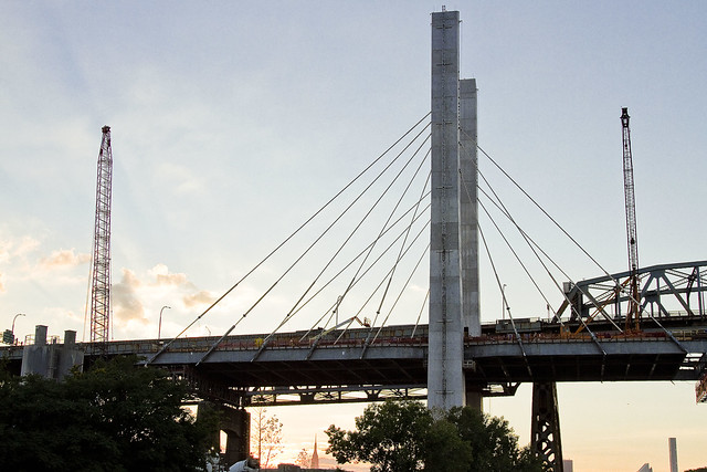
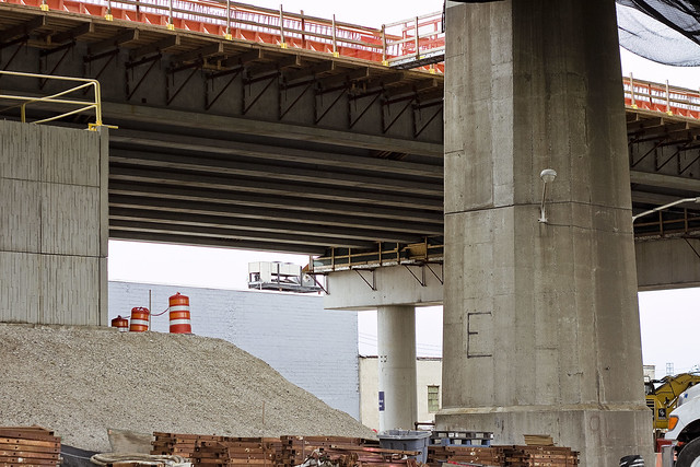
Lets talk about the Kosciuszcko Bridge, huh?

– photo by Mitch Waxman
Since the big bridge over Newtown Creek’s 77th birthday is coming up – August 23rd for the vulgarly curious – one decided to walk over and through Calvary Cemetery into West Maspeth the other day and check out the latest progress which the NYS DOT and their contractors are making on replacing it. The Kosciuszcko Bridge replacement project is humming along.
As a note, this post represents no special access or anything, just some specialized knowledge about Newtown Creek and the points of view thereupon which I am privy to. If there’s an angle of view on the Creek I don’t know about by this point, I will buy you a drink for showing it to me.

– photo by Mitch Waxman
As is my habit, one has been keeping a running tally of posts about the project.
To start – this 2012 post tells you everything you could want to know about Robert Moses, Fiorella LaGuardia, and the origins of the 1939 model Kosciuszko Bridge. Just before construction started, I swept through both the Brooklyn and Queens sides of Newtown Creek in the area I call “DUKBO” – Down Under the Kosciuszko Bridge Onramp. Here’s a 2014 post, and another, showing what things used to look like on the Brooklyn side, and one dating back to 2010, and from 2012 discussing the Queens side – this. Construction started, and this 2014 post offers a look at things. There’s shots from the water of Newtown Creek, in this June 2015 post, and in this September 2015 post, which shows the bridge support towers rising. Additionally, this post from March of 2016 detailed the action on the Queens side. Most recently, here’s one from May of 2016, and one from June of the same year.

– photo by Mitch Waxman
The roadway which will be the easterly BQE section leading out of Queens is now largely in place. There’s still a bunch of work going on up there, presumptively it involves the sort of rebar work observed in the May 2016 post linked to above.

– photo by Mitch Waxman
The shape of the cable stay section of the new bridge is beginning to form up as well.

– photo by Mitch Waxman
The steel sections are prefabricated and shipped to the job site via flat bed truck, where they’re then hoisted up and attached to the towers and cables.

– photo by Mitch Waxman
Looking down 56th road from Blissville into Maspeth. The area in the left hand side of the shot used to be an NYPD tow yard, which was a great example of NYC’s macabre sense of humor. NYPD tow pounds are typically in places which you can’t reach without a car, and since they’ve just taken your car…

– photo by Mitch Waxman
Looking north towards Sunnyside from 56th road. You can really discern the difference in height between the 1939 and modern bridges in the shot above. Apparently, part of the traffic engineering underlying the new bridge project is to eliminate the steep incline from the approaches.

– photo by Mitch Waxman
Looking south towards Brooklyn, while still on 56th road. The property fence line I’m shooting over is the former home of the Phelps Dodge refinery, which is said to be a particularly toxic hot spot.

– photo by Mitch Waxman
A bit closer to the water, on another part of the former Phelps Dodge properties which isn’t quite so “hot,” pollution wise. This is the parking lot of a wholesaler catering to the restaurant trade.

– photo by Mitch Waxman
The cable stay span of the new bridge is growing steadily towards Brooklyn in the shot above. To me, it looks like it’s going to be connected to the Brooklyn side ramp fairly soon.

– photo by Mitch Waxman
A close up on the ramp, and you can see the itty bitty construction guys at work right on the edge.

– photo by Mitch Waxman
Same perspective, but wide angle. That’s the Newtown Creek flowing below, and we are looking west towards Manhattan. Again, notice the height differential between the two spans.

– photo by Mitch Waxman
Looking south again, this time from Maspeth’s 43rd street. The contractors have a lot of their equipment and prefabricated materials staged out here.

– photo by Mitch Waxman
Back on 43rd street, but this time from the very edge of the project site, looking south along the spine of the BQE.
There you are.
Upcoming Events and Tours
Sunday, August 14th, 11:00 p.m. – 1:00 p.m. –
Calvary Cemetery Walking Tour,
with Atlas Obscura. Click here for more details.
Sunday, August 21, 11:00 a.m. – 1:00 p.m. –
Poison Cauldron Walking Tour,
with Atlas Obscura. Click here for more details.
Wednesday, August 24, 6:00 p.m. – 8:00 p.m. –
Port Newark Boat Tour,
with Working Harbor Committee. Click here for more details.
“follow” me on Twitter- @newtownpentacle
unequal heating
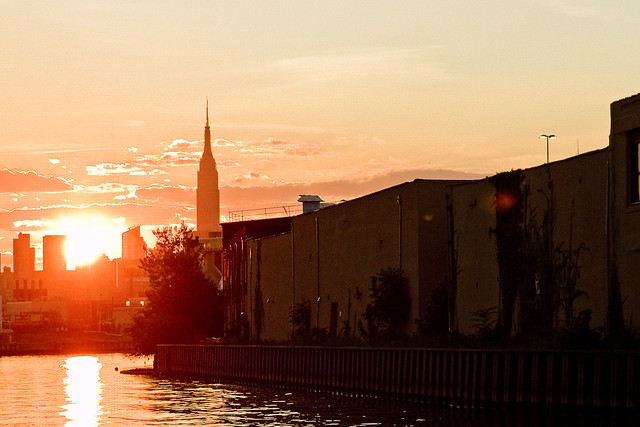
Creek Week concludes, in today’s post.
– photo by Mitch Waxman
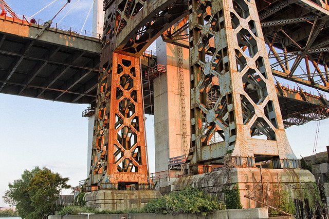
That’s the Kosciuszcko Bridge replacement project pictured above, with the 1939 Robert Moses model bridge providing a backdrop to the under construction cable stay model. That’s the Brooklyn side, for the curious. This is a $1.2 billion replacement effort, “fast tracked” by Governor Cuomo, which is intended to replace what’s considered to be the most dangerous bridge in New York State – which happens to carry hundreds of thousands of vehicle trips a day as the Brooklyn Queens Expressway runs across its 2.1 mile long structure (along with its approaches).
– photo by Mitch Waxman
These shots were captured while onboard a NY Water Taxi hired for the evening by the Open House NY organization, and my colleague T. Willis Elkins and I were onboard to represent Newtown Creek Alliance and narrate to two sold out crowds. The second trip was heading back out from the Newtown Creek towards the East River just as sunset was occurring, and as always – Newtown Creek was and is a visual spectacular.
– photo by Mitch Waxman
One has been trying to capture as many angles and shots as possible of the old Kosciuszcko Bridge for a couple of years now, simply because within the next 24-36 months it will have been eradicated from common memory.
This whole “Newtown Creek Historian” business isn’t just about revealing the past, it’s about leaving behind a visual record for those who haven’t been born yet about what the place looked like during its superfund and early 21st century transformational period.
– photo by Mitch Waxman
I’ve mentioned it before, but the plan which the State DOT has put forward is that once the eastern side of the new bridge is complete, they are going to reroute the BQE onto it. Then, they’re going to demolish the 1939 model, and in its footprint, build the western section of the new cable stay bridge. The great news about that is that there is going to be a pedestrian and bicycle path on the western side of the bridge.
One looks forward to walking the camera across, and getting aerial shots from up there.
– photo by Mitch Waxman
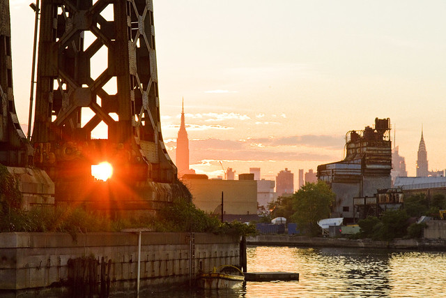
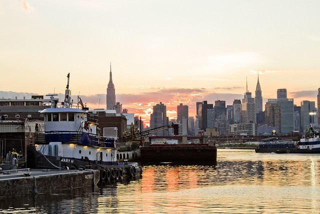
The burning thermonuclear eye of God itself was setting in the west as our NY Water Taxi navigated back towards the East River. That’s Blissville in Queens on the right hand side of the shot above, and the former location of not just Charles Pratt’s “Queens County Oil Works” but just about the very spot where the first large scale oil refinery in the United States – Abraham Gesner’s “North American Kerosene Gas Light Company” was founded.
– photo by Mitch Waxman
On the Brooklyn or Greenpoint side of Newtown Creek, the former home of the Standard Oil Company of New York and birthplace of what would be one day known as Mobil Oil is closest to the camera, which are now the ExxonMobil Greenpoint Remediation Project properties at 400 Kingsland Avenue.
Sitting on part of the former oil company properties in Greenpoint is the NYC DEP’s Newtown Creek Wastewater Treatment Plant, largest and newest of NYC’s 14 sewer plants.
– photo by Mitch Waxman
DUGABO – or Down Under the Greenpoint Avenue Bridge Onramp – is the heart of petroleum country on Newtown Creek. Greenpoint Avenue heads west into Brooklyn, terminating at the East River at Transmitter Park, whereas it continues into Queens and once having crossed Queens Blvd. – it transmogrifies into Roosevelt Avenue and continues all the way out into Flushing.
– photo by Mitch Waxman
From a maritime industrial point of view, the DUGABO area surrounding the Greenpoint Avenue Bridge is probably one of the busiest sections of Newtown Creek in the 21st century. SimsMetal and Allocco Recycling host regular tug and barge traffic, as does Metro fuel.
In the distance is the Pualski Bridge and the towers of the Shining City of Manhattan.
Upcoming Events and Tours
Saturday, August 6th, 2:00 p.m. – 4:00 p.m. –
Insalubrious Valley Walking Tour,
with NY Adventure Club. Click here for more details.
Sunday, August 14th, 11:00 p.m. – 1:00 p.m. –
Calvary Cemetery Walking Tour,
with Atlas Obscura. Click here for more details.
Sunday, August 21, 11:00 a.m. – 1:00 p.m. –
Poison Cauldron Walking Tour,
with Atlas Obscura. Click here for more details.
“follow” me on Twitter- @newtownpentacle
tradition emphasizes
Creek week continues, in today’s post.

– photo by Mitch Waxman
As promised in yesterday’s post, a different perspective on the Creek is offered today. For the last few days, we’ve been on the DEP property in Greenpoint, and a birds eye perpective on DUGABO – Down Under the Greenpoint Avenue Bridge Onramp – was offered. In today’s post, the POV is from onboard a NY Water Taxi, and it’s the English Kills Tributary of the larger Newtown Creek.

– photo by Mitch Waxman
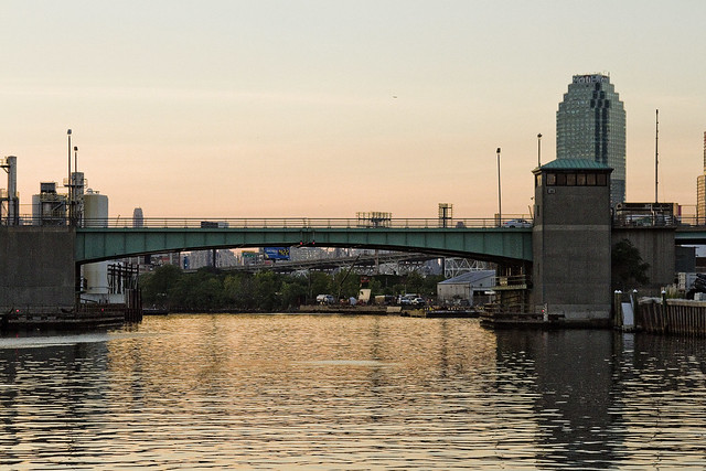
That’s the Metropolitan Avenue Bridge, as seen from the turning basin adjoining it, looking east towards Bushwick and East Williamsburg. I call this spot DUMABO – Down Under the Metropolitan Avenue Bridge Onramp. In colonial times, this was traditionally the demarcation point between fresh and brackish water on the Creek, but back then English Kills was fed by dozens of upland streams and springs. The water bubbling up out of the earth up on the hills of Ridgewood and Bushwick are part of what drew the Germans out here, and a lot of them – like the Ulmers – were involved in the beer business.
The beer guys, who do the holy work of delivering sacrament to bars and bodegas, are still in the area but there’s mainly micro brew hipster stuff going on these days and it’s fed by the DEP’s croton water system rather than ground water. The big guys like Budweiser – pictured above – ship their product in from elsewhere. There’s a pretty big beer distributor nearby on Grand Street, whose warehouse backs up on English Kills, and that Bud Light truck is likely heading there.

– photo by Mitch Waxman
Also on Brooklyn’s Grand Street is the former Charles J. King recycling company, which seems to have recently changed ownership. Luckily, the new owners continue to exploit their maritime bulkheads to ship their product out of the area, rather than truck it out. The sections of Brooklyn and Queens surrounding the eastern sector of the Newtown Creek have some of the highest concentrations of heavy truck traffic in the entire City of New York.

– photo by Mitch Waxman
That’s the NYC DOT’s Grand Street swing bridge in the shot above, a 1909 relic of the days when Tammany Hall came to Newtown Creek shortly after the consolidation of the City of Greater New York in 1898. It’s the titular ornamentation signifying the positioning of the currently undefended legal border of Brooklyn and Queens. On the Queens side of the bridge, Grand Street becomes Grand Avenue, which travels through Maspeth and several other communities. Despite a few interruptions in its path introduced by Robert Moses, Grand Avenue eventually enters Astoria and becomes 30th avenue which heads all the way down to the East River near Halletts Cove.
Of course – on the Brooklyn side – Grand Street more or less connects to the East River in Williamsburg.

– photo by Mitch Waxman
The Brooklyn side concrete company pictured above, called Empire Transit Mix, is sited on what was once called Furman Island. There used to be two islands found in the neighborhood of Maspeth Avenue, with the smaller one known as Mussel Island. Mussel was dredged away in the WW1 era, and its spoils were used to connect Furman Island to Brooklyn. This netted Brooklyn a bit of additional land mass and supposedly increased its legislative delegations by one seat.
Furman Island is the former home of Peter Cooper’s Glue Factory, Martin Kalbfleisch’s Acid and Chemical works, and Conrad Wissel’s Night Soil and Offal dock.

– photo by Mitch Waxman
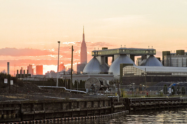
The area where the Newtown Creek widens out is referred to as “the Turning Basin” and it’s where you’ll find the National Grid company’s LNG facility, which sits on a former Manufactured Gas Plant which was operated by the Brooklyn Union Gas Company. There’s a lake of coal tar under the National Grid property, and a wall of the stuff clinging to their property in the water.
As a note, I have made multiple attempts to formally visit the National Grid site, using institutional means. Polity and smarmy conviviality have been met with a brick wall of denial of entry. Every attempt to learn what goes on there has been met with obfuscation and a cry of “Homeland Security.” It’s a “no cameras” zone, National Grid says. It’s a “Marsec 1” zone, National Grid says.
It’s visible from above, via the Kosciuszcko Bridge, and from the water, and from the street sides – say I. I’ve got long zoom lenses, as well. I’ve also got access to documentation on the place via the environmental review process, State DEC oversight, and the Superfund investigations.
One wonders what they’re hiding back in there. I’ll find out over the course of time.

– photo by Mitch Waxman
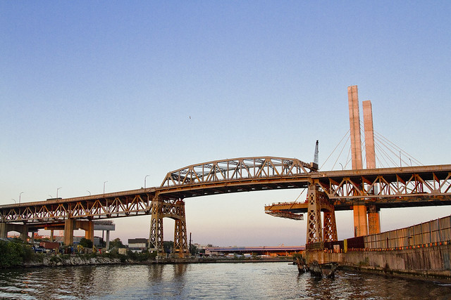
Speaking of the Kosciuszcko Bridge, at the western end of the turning basin, you’ll find the 1939 span and the replacement span which the State DOT is currently working on.
These shots were captured just last week while onboard a pair of sold out Open House NY tours of the Newtown Creek which I conducted with my colleague T. Willis Elkins from Newtown Creek Alliance. My practice on these tours is to narrate the excursion – discussing the past – in from the East River to the Metropolitan Avenue Bridge, then hand the microphone over to Willis – who discusses the future.
While he’s talking, one grabs the camera and gets busy.
Upcoming Events and Tours
Sunday, August 14th, 11:00 p.m. – 1:00 p.m. –
Calvary Cemetery Walking Tour,
with Atlas Obscura. Click here for more details.
Sunday, August 21, 11:00 a.m. – 1:00 p.m. –
Poison Cauldron Walking Tour,
with Atlas Obscura. Click here for more details.
“follow” me on Twitter- @newtownpentacle
tourist parties
Bottoming out in Blissville, in today’s post.

– photo by Mitch Waxman
A recent Saturday found me speaking at an early morning waterfront event in Astoria recently, which was followed by conducting a walking tour of the Poison Cauldron of the Newtown Creek in the late afternoon. Left with a gulf of time to fill between the two, I decided to spend it by walking from Astoria to Greenpoint via Blissville and checking in on what’s going on with the Kosciuszko Bridge project on the border of West Maspeth and the aforementioned Blissville section of Long Island City.
A bit of history trivia is offered – the Kosciuszko Bridge is built along the “legal” south eastern border of Long Island City and what was once known as “Newtown.” For the curious, the North Eastern border was more or less defined by Woodside Avenue.

– photo by Mitch Waxman
The roadway ramps on the Queens side of the Kosciuszko Bridge project are now overflying Review/58th avenue and reaching towards Newtown Creek. The Kosciuszko Bridge project engineers have always said that the northern section of the project would lag behind the southern, or Brooklyn, side.
Longtime readers of this – your Newtown Pentacle – will report that I’ve been keeping track of things at the Kosciuszko Bridge, with this recent post being the latest report from the Brooklyn side.

– photo by Mitch Waxman
For a running history of Newtown Pentacle coverage on the subject – this 2012 post tells you everything you could want to know about Robert Moses, Fiorella LaGuardia, and the origins of the 1939 model Kosciuszko Bridge. Just before construction started, I swept through both the Brooklyn and Queens sides of Newtown Creek in the area I call “DUKBO” – Down Under the Kosciuszko Bridge Onramp. Here’s a 2014 post, and another, showing what things used to look like on the Brooklyn side, and one dating back to 2010, and from 2012 discussing the Queens side – this. Construction started, and this 2014 post offers a look at things. There’s shots from the water of Newtown Creek, in this June 2015 post, and in this September 2015 post, which shows the bridge support towers rising. Additionally, this post from March of 2016 detailed the action on the Queens side.
– photo by Mitch Waxman
Supposedly, I’m meant to be gaining some access to the actual worksite in Queens fairly soon, although the only thing keeping me from having walked the site is my own discretion. As far as “urban exploring” goes, this would be an easy conquest. Regardless, I’m looking forward to walking the site sometime in June.
– photo by Mitch Waxman
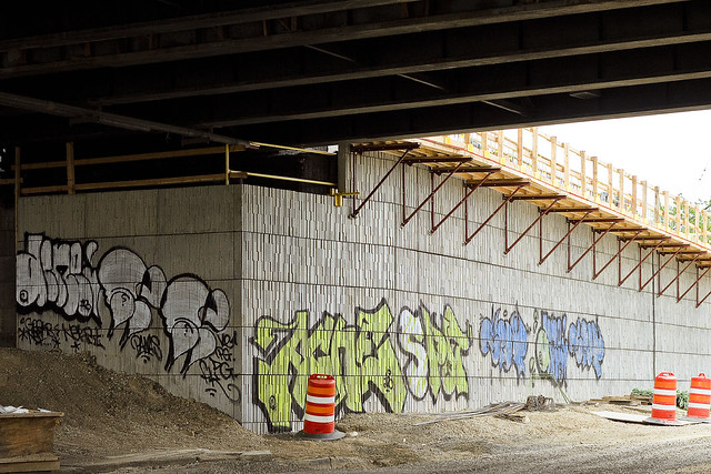
To wit, a graffiti crew which decided to adorn the still under construction masonry of the new Brooklyn Queens Expressway ramps leading to the span. Another crew a little bit further north of here weren’t quite as colorful, and instead painted white swastikas on the brick masonry of the BQE on-ramps.
What you see above is not graffiti, incidentally, it’s time.
Time and opportunity.
Upcoming Events and Tours
Saturday, June 4, 11:00 a.m. -1:30 p.m. –
DUPBO: Down Under the Pulaski Bridge Onramp,
with Brooklyn Brainery. Click here for more details.
“follow” me on Twitter- @newtownpentacle
doom that
Kosciuszko Bridge visit, a few random things I noticed.

– photo by Mitch Waxman
A couple of days back, a fairly enormous posting detailed the latest visit to the Kosciuszko Bridge replacement project in Greenpoint. The shots in today’s post were candidates for that post, but I had to draw a certain line in the name of being concise in terms of the overall narrative. It was a progress report, after all. Today, some of the cool stuff I saw which didn’t fit into the structure thereof.
I love taking shots of people welding or working with metal and torches. There’s two ways to approach this shot, btw. One is to use a high ISO and insanely fast shutter speed to freeze the individual sparks. The other is to lower the ISO sensitivity and use a slower shutter. The shot above uses the former approach, which freezes all the little sparks. The latter approach allows the sparks to stretch out and look like fiery spaghetti.

– photo by Mitch Waxman
The shot above is from up on the still under construction roadway and overlooks the National Grid site in Greenpoint. I don’t know ANYONE who has ever personally visited this site, and it remains one of the “black boxes” on the Newtown Creek. By “black box” I mean that it’s like fight club when you ask the National Grid Guys about it, and you don’t talk about fight club. This is looking easterly, towards Maspeth.

– photo by Mitch Waxman
Turning on my heels, as it were, and looking south along Meeker Avenue/Brooklyn Queens Expressway towards Manhattan. For some reason, the chattering lunatic voice which constantly wails between my ears and behind my eyes has started referring to Manhattan as “Manchuquo” in recent weeks. I don’t know why. It won’t be the first time that I remind you that I’m an idiot.

– photo by Mitch Waxman
The Kosciuszko Bridge, Brooklyn side, is absolutely surrounded by waste transfer stations. Something close to 40% of NYC’s trash (by ton) comes to within about a mile of the bulkheads of Newtown Creek and its tributaries for processing. Last time I checked, the City generates about 12 million tons of trash a day, and since I’m mathematically challenged – I’ll allow you to do the calculations.

– photo by Mitch Waxman
Gear, gear, gear. These construction guys have the coolest toys to play with you’ve ever seen. The vehicle above had some sort of crane/winch thing on it which appeared to be able to telescope out of the hydraulic boom that was set into the rear of its chassis, scorpion style. This particular device seemed to be just a few generations away from the the exoskeleton rig that Ripley used in the movie “Aliens.”

– photo by Mitch Waxman
This shot came from a temporary staircase set against the new overpass’s abutment/retaining wall. This has to be around 50-60 feet up from the deck. One of my many, many phobias – albeit a minor affliction in my portfolio – involves heights. In my mind, it’s a good defense mechanism, as falling 50-60 feet will kill you dead. Saying that, just looking at this picture causes neurological symptoms to manifest in the muscles controlling my hands.
Upcoming Events and Tours
Sunday, May 8th at 11 a.m. – North Henry Street Project,
with Municipal Arts Society Janeswalk and Newtown Creek Alliance,
in Greenpoint, Brooklyn. Click here for more details.
“follow” me on Twitter- @newtownpentacle


