Posts Tagged ‘Greenpoint’
ever been
Monday

– photo by Mitch Waxman
April 24th saw a humble narrator more or less walk the entire Brooklyn side of Newtown Creek, and by the time I reached the Pulaski Bridge all of my aches and pains were absolutely singing an opera.
That’s when you really just have to lean into it, I always say, and keep on scuttling. You want to know something, though? What I’ve really been missing the last month or so, and especially during low energy moments like the one I was experiencing while getting ready to surmount the Pulaski, has been having my headphones plugged into my ears while they’re blaring early Black Sabbath.

– photo by Mitch Waxman
Personal security, however, demands that all of my senses remain unoccluded. I need to be able to hear “it” if and when it’s coming. It’s funny, actually, that this section of Newtown Creek is one of the areas which I’ve assiduously avoided throughout the pandemic months. The population has become particularly dense here, due to what a friend of mine refers to as “the real estate frenzy.” That isn’t why I’ve been avoiding it, though.
Anywhere that lots of people are, that ain’t where I been.

– photo by Mitch Waxman
Pulaski Bridge has a dedicated pedestrian and a seperated bike lane, in addition to its lanes of vehicular traffic. It’s a double bascule drawbridge, and electrically powered. It connects McGuinness Blvd. in Brooklyn’s Greenpoint with 11th street at Jackson Avenue in Queens’ Long Island City. Along the way, on the Queens side, it also overflies the Long Island Railroad’s Lower Montauk tracks and the Queens Midtown Tunnel.
It’s extremely well traveled, and each one of its several traffic lanes is quite busy. It’s also fairly easy to get into trouble up there, precisely because of its populous nature. I used to know a guy who got jumped midspan, and who laid there bleeding from a head wound while the Brooklyn and Queens cops were arguing about which precinct the mugging occurred in – 94th or 108th. Neither one “wanted it” as it would cause their “house’s” crime stats to go up.

– photo by Mitch Waxman
There used to be an amazing series of NYC views up on the Pulaski, with the Empire State Building at the center of your frame and reflected in Newtown Creek. The sky has been stolen by big real estate, however. It’s been privatized. If you’re looking for “inspirado” you better have some cash to pay for it.
The good news is that our elected officials continue to subsidize the real estate people, by bending the rules for them and handing out multiple decade long tax breaks in the name of “affordable housing.”

– photo by Mitch Waxman
The dodge accomplished by the Real Estate people is to establish a development corporation as an ‘’LLC” or “Limited Liability Corporation” for the duration of planning and construction. The day after they cut the ribbon on a new building, the original development LLC, which made all the deals with the city and state, is dissolved and the property is transferred to a management LLC that can pick and choose which tenets of the original LLC’s political contracts they want to oblige.
Either way, they’re not paying any taxes for a long time. Not paying into the cops, or the schools, or the hospitals which their tenants in their thousands consume the services of. Remember when the Governor set up the Javitz center as a mass casualty hospital at the start of COVID? That’s because NYC doesn’t have enough hospital beds anymore.

– photo by Mitch Waxman
Some enterprising soul poked a hole in the chain link fences of the Pulaski’s pedestrian walkway a few years back, one that allows a view down into the Queens Midtown Tunnel’s entrance.
August of 1940 is when the tunnel opened, along with the section of the Long Island Expressway which feeds about 32 million vehicle trips a year into the thing. At least you can still see the Empire State Building from here since the Real Estate people haven’t convinced the politicians that it would solve the homeless problem if we decked over the tunnel’s toll plaza over and built luxury condos on top.
Give it time. Swagger.
“follow” me on Twitter- @newtownpentacle
Buy a book!
“In the Shadows at Newtown Creek,” an 88 page softcover 8.5×11 magazine format photo book by Mitch Waxman, is now on sale at blurb.com for $30.
psychopathic institution
Tuesday
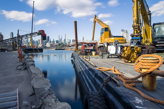
– photo by Mitch Waxman
So, a few weeks back, a barge sunk into the gelatinous waters of the gregarious Newtown Creek. This isn’t the first time, won’t be the last, this sort of thing happens. Nothing nasty got released into the water, the barge was filled with rock and sand. Saying all that, it’s quite the pickle raising a barge sitting under 20-30 feet of water, and it requires specialized gear and a crew of experts. Luckily, NY Harbor being NY Harbor, there are a couple of outfits which will rent you the equipment and help you hire the experts needed to operate their stuff.
That’s capitalism for ya, huh? There’s a solution to every problem, if the price is right. Given the times we live in – that’s not a critique of our grandiose economic system, rather it’s an appreciative comment on a part of its feature set.
– photo by Mitch Waxman
Lucky for a humble narrator, this particular barge went down in a spot nearby a location which I’ve got access to over in the Greenpoint section of Brooklyn. After attending a Newtown Creek Alliance press event in Maspeth earlier in the day, which involved a couple of Congress members and a gaggle of local “electeds,” I hitched a ride back to Greenpoint and got busy.
It was the worst time of day for light during the winter – right around noon o’clock – but I was prepared for that, and the tripod was deployed with an ND Filter affixed to the lens to slow things down and control the amount of light a bit. I got “a-clicking.”
– photo by Mitch Waxman
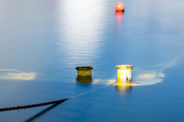
It seems that there was a diver in the water, who was attaching ropes and airbags and all sorts of arcane hoses to the sunken barge. That hit of motion blur on the crane’s arm betrays the process – with the diver and laborers moving ropes and chains around and under the sunken barge. Every now and then, you’d see the diver’s helmet pop up out of the drink.
How exciting.
“follow” me on Twitter- @newtownpentacle
Buy a book!
“In the Shadows at Newtown Creek,” an 88 page softcover 8.5×11 magazine format photo book by Mitch Waxman, is now on sale at blurb.com for $30.
he screams
Tuesday

– photo by Mitch Waxman
That’s the Kosciuszcko Bridge, crossing my beloved Newtown Creek, pictured above. One had scuttled here from the Brooklyn Navy Yard along Meeker Avenue, and since my trick left foot was acting up, I decided that this would be an excellent place to chill out for a bit. As mentioned yesterday, a bathroom break was also required. There’s usually an unlocked Porta Potty down here, so that was my first destination in and area I call DUKBO – Down Under the Kosciuszcko Bridge Onramp (the Porta Potty was a great experience, I gave it a three out of four stars Yelp review).
I set up the camera on the tripod and got busy, afterwards. Of course, I could have gotten away with just doing hand held shots here, as it wasn’t even close to noon o’clock yet. Saying that, I wanted to “slow things down” a bit and attached a filter to my lens to cut down on the amount of light entering it. Smooth out some of the distracting texture and reflection in the water, all that.

– photo by Mitch Waxman
One finds its fascinating, actually. When you’ve got the shutter open for 10-30 seconds, you can begin to visualize the currents in the water column. See how, and where, the flow goes, y’know’s?
My pals at Newtown Creek Alliance shake their heads “no” at me when I describe my desire to release hundreds of thousands of rubber duckies into Newtown Creek, just to see where they go and illustrate how the currents work. Something about “micro plastic” and illegal dumping pretty much describes their objections. They also don’t like my plan to seed pumpkins and or carnivorous plants into the shorelines in Maspeth. No fun.

– photo by Mitch Waxman
You’ll notice structures like the one pictured above all over the harbor, and their purpose is to provide protection for shoreline features from passing maritime traffic. Called “dolphins,” they’re generally a bunch of wooden piles held together with galvanized steel rope. This is one of the ones which protect the piers of the Kosciuszcko Bridge, but it’s obviously associated with the 1939 version, rather than the newer one that’s currently extant.
The wood is likely creosote treated, which is why it hasn’t rotted away. Creosote is a chemical treatment for wood – usually coal tar creosote or petroleum creosote in a setting like this- which involves placing wood in a vacuum chamber to rid it of any water in the wood’s cellular matrix and then after introducing the creosote into the chamber, reversing the pressure to several atmospheres to force the creosote into the wood’s cellular lattice. This effectively makes the wood a hostile environment for micro and macro organisms. This process is used for railroad sleeper ties, dolphins, piers, utility poles and a host of other applications. Creosote is also a major component of a substance sold as a food flavoring additive called “Liquid Smoke.”

– photo by Mitch Waxman
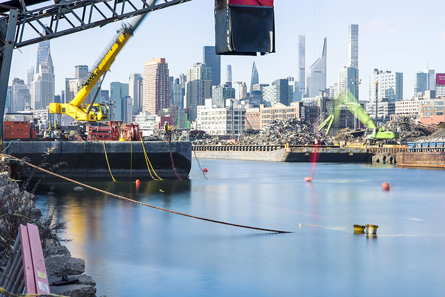
Over on the Queens side of my beloved Newtown Creek, that’s the former site of the Penny Bridge. It’s also formerly a Long Island Railroad Lower Montauk line station called “Penny Bridge.”
Just to recap my day to this point, I left HQ in Astoria at about 4:30 in the morning and made it over to the NYC Ferry dock at Hallets Cove. From there, I captured shots for a photo assignment at the Brooklyn Navy Yard and then walked along and under the BQE through Brooklyn to this spot at Newtown Creek. The shot above was captured at about 10:30 in the morning on November the 21st, so I’d been “at it” for quite a while at this point.

– photo by Mitch Waxman
I’d ingested a meal along the way, a standard NYC egg sandwich and a container of orange juice which I grabbed at some deli in Williamsburg. Saying that, I had become fairly dehydrated by this point and was regretting my normal prohibition against carrying bottles of fluid. This habit of mine, which is prosaic as I’m literally carrying high capacity batteries and electronic devices all around my person, has bit me in the ass several times recently. Have to work out a way to get around my physical needs, I always think.
Between my sweatshirt – which hosts 22 distinct and secure pockets – my usual pants – which have 13 pockets – and the filthy black overcoat with its two pockets, and the ubiquitous camera bag(s) – I’ve got to figure out some spot where I can secret away a pint of water. Of course, then you have to pee again, so it’s a recursive feedback loop.

– photo by Mitch Waxman
I made one more stop after this, and then abandoned the entire idea of walking the rest of the way home due to the operatic condition offered by the trick left foot which I’ve been complaining about for what feels like years now. Internal dialogue wise, I refer to my feet as “the roadway interface” and having a full 50% of this apparatus malfunctioning has become a bit more than an annoyance. It’s slowing a humble narrator down, damnit.
More tomorrow.
“follow” me on Twitter- @newtownpentacle
Buy a book!
“In the Shadows at Newtown Creek,” an 88 page softcover 8.5×11 magazine format photo book by Mitch Waxman, is now on sale at blurb.com for $30.
he shuns
Monday

– photo by Mitch Waxman
As described, last year, a humble narrator’s perambulatory pursuits found him shambling eastwards on Brooklyn’s Meeker Avenue from the Brooklyn Navy Yard towards Astoria in Queens. My route was entirely encapsulated by the miles long steel and concrete pergola formed by the elevated roadway of the Brooklyn Queens Expressway. There has always been a population that dwells in this corridor – unfortunates and inebriates who set up camp sites constructed from tarps, cardboard, and shipping palettes – but during the pandemic months their numbers have exploded.
Empathy for their plight and situation would be expressed if I was still capable of experiencing emotions. Instead, one has become not unlike a stick of wood – dry, unyielding, uncaring, ready to burst into flame at the first hint of a spark. I’m intolerant of nonsense now, and it’s nonsensical that the greatest City in history cannot do anything about this situation other than build luxury condominiums in Manhattan’s Soho… but, alas, my new motto still applies – “Nothing matters and nobody cares.”

– photo by Mitch Waxman
This section of Brooklyn was once where the political boundary between Bushwick and Greenpoint was drawn, back when your electeds were called “Alderman” or “Ward Boss.” That’s before Robert Moses arrived on the scene in the late 1920’s. Moses was quite keen on something he referred to as “The Brooklyn Queens Connecting Highway” and after his ribald success in building both Mighty Triborough and the Grand Central Parkway, the Federal Government agreed to fund his ideation. Moses made the case that the multitudes of Brooklyn would choke local street traffic as they made their way to his 1939 World’s Fair in Flushing, and that a high volume/speed road was required.
Moses showed a certain predilection for building his projects right on the border between two political districts. The highway above required the whole scale demolition of a city block wide corridor, and thousands of homes and businesses were eradicated to clear the space. I’d imagine having two politicians feeding at his trough rather than one made the disruption to the locals easier to handle.

– photo by Mitch Waxman
The modern day Brooklyn Queens Expressway was christened in the post WW2 Urban Renewal era. The original road was a highway, which means a high speed road with frequent exit and entrance ramps and in places – bike and pedestrian paths – but when it became an expressway it lost several of those ramps and any thought of pedestrian access was removed. Parkway (planted shoulders), highway (high speed), throughway (no exits except at start and end), expressway (limited exits). These are all self explanatory terms, Moses would tell you, before offering analogies about breaking eggs and omelettes. The usage for the space below the elevated truss road was meant to saturate parking availability, but as you can see – “world longest homeless camp” is largely how it’s being used today.
The Brooklyn Queens Connecting highway, or at least the sections of it north of the Williamsburg Bridge leading into Queens, opened for business during the month of August in 1939. August 23rd, to be exact.

– photo by Mitch Waxman
One is supposed to be empathic towards those who dwell below. That’s virtue signaling horse shit, however. Nobody cares, nothing matters, and these people will be taken care of when the politicians and the crooks who buzz around them like shit flies figure out a way to make political capital and money off of the situation. Personally, everytime I buy a new bag of socks, the older ones get washed and thrown in a shopping bag which I leave nearby similar campsites, or are handed off to one of the many people I encounter in Queens who are living rough. I’m one bad month away from being in this situation myself, and my resources are best analogized as “not enough butter spread over too much bread.”
Life is cheap in the big city, but living costs a fortune.

– photo by Mitch Waxman
By this stage of the walk back to HQ in Astoria, one was beginning to experience fatigue. The trick left foot was singing an opera, and since my left leg was dragging a bit due to the foot, that caused a cramp to set up in my back. NYC doesn’t acknowledge human biology and thereby a series of urine splotches marked my northward progress. I also had to poop, but I’m not that far gone yet. I’ll gladly slip between two parked cars and piss into a sewer grate, but dropping a deuce in the open air isn’t a line I cross.
Also, what if somebody saw it? That’s how you end up on Instagram. “Hey, check out Mitch from Newtown Creek Alliance, he’s shitting in the street now.” Clearly, this signals that their entire thing is a corrupt eidolon offered up by real estate interests and morally bankrupt politicians. Told you he’s no good. I have a friend who advocates for bike lanes and safer streets, and he got photographed jaywalking and that spawned several days of commentary, for instance.

– photo by Mitch Waxman
My destination in this section of Brooklyn was ultimately the Kosciuszcko Bridge, which would carry me into Queens. There’s a neat bit of public space under the new bridge, where – coincidentally – I know there would a “Porta Potty” where I could solve my alimentary issues in private. Along the way, a park bench of two offered some relief for the operatic conditions being offered by the left foot.
More pedantic adventures tomorrow, at this, your Newtown Pentacle.
“follow” me on Twitter- @newtownpentacle
Buy a book!
“In the Shadows at Newtown Creek,” an 88 page softcover 8.5×11 magazine format photo book by Mitch Waxman, is now on sale at blurb.com for $30.
curiously articulated
Thursday

– photo by Mitch Waxman
A quick one today. That’s the composition I had planned for the tribute in lights shot, but for whatever reason they didn’t have them on. C’est la vie, huh?
Still, I’m pretty happy with the shot above.

– photo by Mitch Waxman
From a bit earlier in the evening, and looking across the Whale Creek tributary of Newtown Creek towards the shield wall of Manhattan.
At least the Empire State Building people decided to light things up appropriately.

– photo by Mitch Waxman
Looking down at the places I normally inhabit: sewer plants, waste transfer stations, the mean streets of Brooklyn.
Back tomorrow, lords and ladies, with something COMPLETELY different. I have actually been outside of NYC for the last few weeks! Vacation, all I ever wanted…
“follow” me on Twitter- @newtownpentacle
Buy a book!
“In the Shadows at Newtown Creek,” an 88 page softcover 8.5×11 magazine format photo book by Mitch Waxman, is now on sale at blurb.com for $30.


