Posts Tagged ‘Long Island City’
unpleasant person
No matter where I go, there I am.

– photo by Mitch Waxman
One has been particularly verbose and vitriolic this week about subjects substantial, which indicates to those who know me that the proverbial process best described in “Brooklynese” as “gettin my shits togetha” has been underway for the last several weeks. The walking tours season has begun, and I’m planning a series of excursions for the year with Mai Armstrong and the various organizations we work with. Cross your fingers and thank the stars – as boat trips, walking tours, and all kinds of cool stuff are being planned. The Atlas Obscura tour listed below has already sold out, I’m afraid, but I’ve got a few pretty cool irons in the fire right now.
While we’re waiting to finalize things, Mai and I decided we might do a walk through Calvary Cemetery with a smaller than usual group, next weekend – probably Saturday. More on this one Monday, and I’ll have a link ready for those of you who might want to come along.

– photo by Mitch Waxman
There’s a few iconic Queens spots which will be hitting centennial anniversaries pretty soon, and I’m trying to figure out a few ways to commemorate that. Again, these things are on the stove’s back burners and simmering right now. A bizarre part of my thought processes, one which always befuddled and confused those unlucky enough to know me, is that I can take a project and tuck it away in my subconscious for processing while my waking mind concentrates on and handles other stuff like walking and laundry. Sometimes these simmering bits are utterly forgotten until I look through one of my notebooks and then – boom – it boils over and unfolds into something conscious and actionable.
Unfortunately, this “unfolding” often happens at 2:30 in the morning, which finds me huddled over the computer scratching away at a project as the sun is coming up. Lack of sleep is why my eyes often look and feel like they’ve been boiled.

– photo by Mitch Waxman
Photography wise, there’s a few new locations and opportunities I’m interested in pursuing this summer, and many ongoing spots that I need to exert some real effort into continuing to document. Within the next two weeks, one plans to roam through the predominance of the municipality of Long Island City’s former borders, and do so with camera in hand. There’s night shots I want, places I’ve never been that I intend on visiting, and nothing – NOTHING – is going to stop me from getting to Aquarium in Coney Island this year. I’ve got boats to catch, trains to find…
It should all be a lot of fun, but it’s all still kind of depressing at the same time.
“follow” me on Twitter- @newtownpentacle
April 16th, Obscura Day 2016 –
“Creek to Creek Industrial Greenpoint Walking Tour” with Mitch Waxman and Geoff Cobb.
Join Newtown Creek Alliance historian Mitch Waxman and Greenpoint historian and author Geoff Cobb for a three-hour exploration of the coastline of Greenpoint. Click here for more info and ticketing.
repellant mannerisms
No more meetings, supposition instead, in today’s post.

– photo by Mitch Waxman
The last few days, you’ve been informed about my various causes and committees, and some of the “inside baseball” on the Newtown Creek story has been offered. There’s more I could tell you, and will in the fullness of time. I’ve got a whole world of weird minglings with the “powers that be” which I can relate, but a lot of these encounters are in situations where some discretion is expected from all parties and I don’t want to act like a jerk and tattle everything I’ve been told about this and that.
One thing which I’ve been annoying the powerful about is the Mayor’s proposed street car system – the BQX. When I bring it up, the powers and potentates of the permanent government exhibit a momentary flash of wild panic, and they then start assuring me that it’s an entirely reasonable proposal, all the while forcing that horrible crocodile grin of the professional politician across their mugs.

– photo by Mitch Waxman
I’ve got the route of this BQX thing figured out, incidentally. It’s an Einsteinian thought experiment, this, and entirely out of my own brain – none of the officials I know will say anything other than “we’re looking at a number of options” even in informal settings. My impression is that the Mayor just dropped this on officialdom and didn’t really check with anyone to see if the BQX was feasible before announcing it, but that’s strictly an impression. The route I list below is based on my personal knowledge gained from thousands of hours walking the western shore of Long Island, coupled with literally hundreds of water born observations.
At the northern side – it’ll start at the former Politti Power Plant by Astoria Park, travel down Shore Road to the corner of Astoria Park South, and then ride on a causeway built into the water, on its way to the Astoria Point development. It’ll roll around the periphery of the peninsula which Astoria Point will share with NYCHA’s Astoria Houses and then come back to shore at Hallets Cove near Socrates Sculpture Garden. It then heads south along Vernon to LIC, turning west at 46th avenue to meet and make a left on Center Blvd. just after Anable Basin. From there, it continues down to second street and a new drawbridge over Newtown Creek, which meets up with West Street in Greenpoint. South along West to Kent and Williamsburg, then around Wallabout Creek to Kent’s intersection with Flushing Avenue. The BQX then tracks south down Flushing Avenue and around the Navy Yard.
I’ll get to Vinegar Hill and DUMBO in a minute.
Let’s just skip ahead to Brooklyn Bridge Park, where Furman Street would carry BQX south to Columbia and then it would track under the Gowanus Expressway through Red Hook and all the way to Industry City in Sunset Park. I think it would be passing over a retrofitted Hamilton Avenue Bridge spanning over the Gowanus Canal.
Hamilton carries the BQX trackway to Third Avenue and – VOILA – you’re at Industry City.

– photo by Mitch Waxman
The fly in the BQX ointment, as I see it, is precisely that Vinegar Hill section and the area which my dad used to refer to as “Downtown Brooklyn” where the Manhattan and Brooklyn bridges converge with Subway lines, highways, a complex of courts, housing projects, government buildings, the rich people in Brooklyn Heights who are easily annoyed and politically relevant, and – literally – the highest real estate valuations which can be found upon the planet along Brooklyn’s Gold Coast.
I have no idea how you’d thread the streetcar needle through that area, and most of the important people (whom you’d be surprised I even know, let alone enjoy congenial relationships with – I still can’t believe some of the folks I get to interact with) I’ve asked how no idea how to do it either. I’ve been told by engineer friends in the construction business that it would be easier to build the two new bridges over Newtown Creek and the Gowanus Canal for this project, simultaneously, than it will be to acquire or afford enough space in “Downtown Brooklyn” for the BQX.
It’s funny, I have no real opinion on this project. I’m neither for, nor against, as I explain to these members of the permanent government whom I condemn to this conversation. I just think it’s kind of an interesting thought experiment, and when the conversation runs its course – alternatively suggest select bus service which could use the route described above, and you wouldn’t have to build any new bridges or buy up parts of DUMBO to accomplish the goal of the thing and achieve a right of way.
“follow” me on Twitter- @newtownpentacle
April 16th, Obscura Day 2016 –
“Creek to Creek Industrial Greenpoint Walking Tour” with Mitch Waxman and Geoff Cobb.
Join Newtown Creek Alliance historian Mitch Waxman and Greenpoint historian and author Geoff Cobb for a three-hour exploration of the coastline of Greenpoint. Click here for more info and ticketing.
iron gray
More meeting reportage, in today’s post.

– photo by Mitch Waxman
Recently, I joined up with another community group – Access Queens – an organization which got its start as a Facebook group called the “7 Train Blues.” I’ve been invited onto the steering committee of Access Queens, which seeks to improve communications between the communities found along the “international express” and the MTA, and to advocate for the riding public. All the history projects I’d been working on in 2014 involving the Sunnyside Yards, and Queens rail in general, has gotten me pretty interested in the Subways.
A recent meeting – on Tuesday, the fifth of April, in fact – was organized by Access Queens in conjunction with Councilmember Van Bramer’s office over at the Sunnyside Community Services facility on 39th street, and the MTA sent out a group of its officers for an “Ask the MTA” session wherein the ridership of the aforementioned IRT Flushing Line could express their frustrations and interact with the agency.
Since I’m the new kid on the block, I kept to the sidelines and took pictures rather than running my mouth for a change. Access Queens had a seat at the table with MTA, in the person of one the group’s leaders – Sunnyside’s Melissa Orlando – and believe you me, I don’t have to say a word when Melissa is present – she’s the real deal.

– photo by Mitch Waxman
An interesting facet to this effort, one that I found particularly novel and kind of fascinating, was that both Van Bramer and Orlando were advancing questions to the transit officials which were being live posted on Twitter and on the 7 Train Blues Facebook group. MTA assured all present, and those in other realms, that their “CBTC” switching conversion work was on schedule. Completion of the project would ultimately allow them to increase the hourly frequency of trains on the already “at capacity” line. Overcrowding on platform and train alike were described by the petitioners from the community. There was also a shed load of media in the room.
A recurring theme emerging from the community was that given the ridiculous amount of real estate mega development occurring all along the Queens side of the 7 – Flushing Commons, Willets Point, and Hunters Point were mentioned in particular – NYC’s infrastructure is being badly strained and pushed to the breaking point.
One of the more interesting things that emerged from the community comments was a request to synchronize the timing of the bus system to coincide with the 7 train delays so as to avoid the “wagon train” phenomena of one full then two empty buses all traveling together. A sight commonly observed by Queensicans.

– photo by Mitch Waxman
A humble narrator, of course, seldom has the “7 Train Blues” given that one dwells upon the IND R line along Broadway in Astoria rather than the IRT 7 along Queens Blvd. and Roosevelt Avenue. The case has been made, however, that when the 7 is delayed, the masses of Flushing, Roosevelt, and Corona use the IND lines (R, M, E, F) instead of the IRT one. This results in quite a situation during morning commutes, and dangerous overcrowding. This is a borough wide phenomena, and is forecast to get worse before it gets better as the population continues to expand along the already overbuilt transit corridors.
Guess that the folks on my side of Northern Blvd. have the “R train blues.”
“follow” me on Twitter- @newtownpentacle
April 16th, Obscura Day 2016 –
“Creek to Creek Industrial Greenpoint Walking Tour” with Mitch Waxman and Geoff Cobb.
Join Newtown Creek Alliance historian Mitch Waxman and Greenpoint historian and author Geoff Cobb for a three-hour exploration of the coastline of Greenpoint. Click here for more info and ticketing.
mapped egress
The horror, in Today’s Post.
– photo by Mitch Waxman
My post last Friday about the 7 line got me thinking about the Subways of Western Queens, which are referred to as “the horror” in conversations with Our Lady of the Pentacle.
It was the 3rd of April, in 1913, that the City of New York purchased the (Steinway) tunnels utilized by what would become known as the 7 line from August Belmont, and in 1915 service started on June 22. They didn’t know it at the time, but those old timey types were creating the most photogenic of all of New York City’s subway lines.

– photo by Mitch Waxman
Even when it’s underground, such as the busted ass Vernon Jackson stop, the IRT line’s 7 looks good. It’s when it moves into Sunnyside and Woodside that the 7 looks best, of course, but there are few stops in Queens where it doesn’t look pretty cool to this itinerant photographer – notably the stop pictured above and the last one in Flushing are comparatively kind of “meh.”
Everything looks terrible in Manhattan, and nobody would go there if they weren’t paid to do so.
– photo by Mitch Waxman
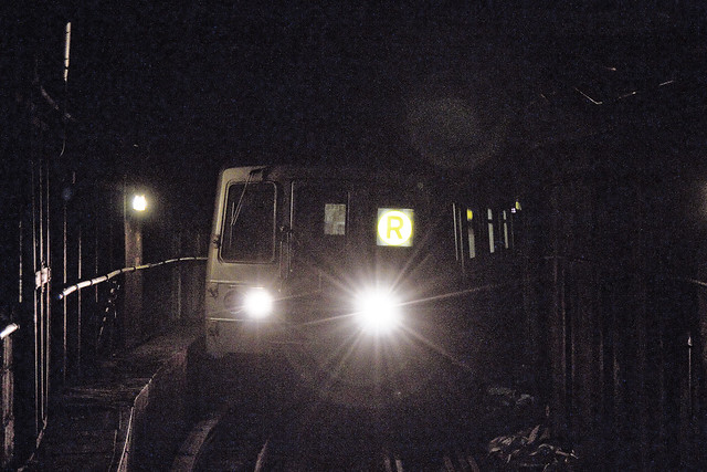
In comparison, the R – which travels on the IND – is the reliable but visually uninteresting line. It didn’t reach Queens until 1920, but back then it only went to Queens Plaza. The modern route, which goes all the way to Forest Hills, was established in 1949 – but back then it was known as the “RR.”

– photo by Mitch Waxman
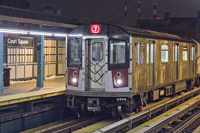
The interesting thing about the Court Square station, to me at least, is that – at least these days – it offers a free transfer between the IND and IRT systems. Downstairs, you’ve got the G, M, and E lines, and upstairs the 7. To continue with the arcane Subway knowledge – the G line became active in 1933, but it was known as the GG back then. The E also came online in 1933, and it is one of the Subway lines that never sees the light of day operationally as its entire route is underground.

– photo by Mitch Waxman
The M is something of a newcomer to the IND Sixth Avenue tracks, although the line was officially designated as early as 1914. It wasn’t until 2010 that the line was routed into its current path mirroring the R service. It actually pisses me off, M wise, that if I wanted to go to Ridgewood – a mere five miles from Newtown Pentacle HQ on Astoria’s southern border – I would need to endure an hour and change long journey through the Shining City to get there.
Before you inform me – yes – I know all about taking the R to Newtown Grand Avenue and catching the bus – I do it all the time.
“follow” me on Twitter- @newtownpentacle
potential responsibility
Creek Week continues, in today’s post.

– photo by Mitch Waxman
After visiting the Kosciuszko Bridge project, 57th avenue, and then Railroad Avenue, a humble narrator’s dogs were barking and a generally homeward course was adopted. As usual, that meant swinging down Borden Avenue and cutting over to Skillman Avenue on the way back to raven tressed Astoria.
My favorite sections of Newtown Creek to photograph are found in LIC, along this particular tributary of the troubled waterway – called Dutch Kills.
It’s something about the light, I guess.

– photo by Mitch Waxman
I haven’t been around here in a few weeks, and I discovered that a formerly fenced in section of the shoreline adjoining the Borden Avenue Bridge had been cleared away, which offered a few points of view which would have formerly required illegal trespass to capture.
Given such an opportunity, a humble narrator will always take it.

– photo by Mitch Waxman
Looking west, towards what I call the “empty corridor” found under the Long Island Expressway truss.
The LIE is some 106 feet high in this spot over Dutch Kills, and was built so to accommodate the stacks of ocean going vessels which were headed for the Degnon Terminal Turning Basin which is about a half mile away. The Federal War Dept. also required this particular height for the possibility of installing warships in the canal in order to protect the industrial sector in case of foreign invasion forces entering New York Harbor (a real worry, prior to the Atomic Bomb).

– photo by Mitch Waxman
Looking eastwards, you see the sort of scene most life long Queensicans would associate with the words “Newtown Creek.” Still, check out that tuney old truck – cool, huh?
“follow” me on Twitter- @newtownpentacle


