Posts Tagged ‘Long Island City’
rhetorical effect

– photo by Mitch Waxman
There is a curious stretch of 50th avenue, a truncated street that starts at 27th street and terminates at 23rd street in the dusty streets of Long Island City, which is orphaned and decapitated. It is dominated by the high flying steel of the Queens Midtown Expressway section of the Long Island Expressway, and the tortured asphalt of the street it shadows often exhibits bursting ruptures revealing century old cobble stones.
Long have I exerted to refer to this area as the “Empty Corridor“.
Pictured above are the relict remains of Irving Subway Grate, which suffered a catastrophic fire a few years back.

– photo by Mitch Waxman
Even during the work week, there are few places in New York City that allow one to feel so isolated and alone as this street. Once it connected with Hunters Point, but that was long before the Queens Midtown Tunnel and the astounding steel viaduct of the Long Island Expressway which sprouts from it were installed and opened to traffic on November 15, 1940.
It was before the Long Island Railroad established its operations that it met with East River, in fact.
Borden and Hunters Point Avenues are the main through way for traffic heading east and west, and this street is little more than relict of earlier times.

– photo by Mitch Waxman
The overhead tracks of the Long Island Railroad are observed at the intersection of 25th street, which govern the passage of large trucks on 50th avenue. Never have these tracks been observed as active by a humble narrator, but those in the know about such matters assure me that they are in fact transited.

– photo by Mitch Waxman
Alongside these tracks, on the loamy midden which surrounds them, one might observe the colonies of feral cats which hunt and frolic around these parts. The kind hearts of area workers insure that these cats are afforded shelter and food, which unfortunately allows them to breed and multiply.
It is not an easy life, to be a feral cat.

– photo by Mitch Waxman
As mentioned in the past, when these nocturnes are observed as my perambulations carry the camera about the concrete devastations of western Queens, a sure notion that the right place and time have been arrived at sets into my mind.
Always, they signal that the path which stretches before me is an appropriate and often revelatory one.

– photo by Mitch Waxman
Beyond the tracks and their feline neighbors, the gargantuan structure with its attendant loading docks on the right are the former Bloomingdales warehouse, and is currently used by the New York City Housing Authority. They refer to it as the “Long Island City Complex” which sounds menacing somehow.
The left (or south) side of the street hosts several garage based businesses, and mainly acts as a parking lot for fleet trucks.

– photo by Mitch Waxman
As the LIE slouches rudely toward the Queens Midtown Tunnel it descends from its 106 foot apex over Dutch Kills, just a few blocks away, and the street noticeably darkens. A guarded parking lot and entrance to the LIRR station lies to the right or north side, which is intended for employee access. To the south, one might follow 23rd street southward, toward Borden Avenue.
An audible hum, the sound of automotive tire spinning upon the elevated roadway above, colors the air.

– photo by Mitch Waxman
The street ends in the driveway of a steel equipment company, which a humble narrator did not feel obliged to explore. What atavist wonders might lurk down there are surely beyond legal access, and are quite visible from the fence which adjoins the LIRR station on Hunters Point Avenue, near the Paragon Oil building. Surely some revelation hides back there, denied to me.
Illegal trespass, however, is not the Newtown Pentacle way.
nothing useful

– photo by Mitch Waxman
Observed, recently along the Boulevard of Death, this cool set of wheels.
Obviously, loved and kept in a state of functional restoration, this atavist vehicle caught my eye.
Occasionally, a humble narrator needs to remind himself to comment on little gems like this late model pickup truck, and marvel that such manufactured items can survive the trials of time.
Offered is the belief that this is either a 1949 or 1950 Chevrolet 3600 pickup, but I’m no expert.
Obcordate, a short posting today. Back tomorrow with something more substantial for you to sink your collective teeth into.
verdant valley

– photo by Mitch Waxman
While preparing the slideshow which was recently presented at the Ridgewood Democratic Club, which is one of two updated versions of the thing (differing lengths), I’ve been churning the content waters deeply. One of the little collections of images which I pulled together was called “Kosciuszko Bridge”.

– photo by Mitch Waxman
For awhile now, special attention has been paid to this decaying structure, due to those plans held by State employees and agencies to replace it with a modern bridge designed to overcome many of the flaws exhibited by the 1939 era “Meeker Avenue Bridge” – which was later renamed as the Kosciuszko Bridge in 1940.

– photo by Mitch Waxman
It’s a lumbering and brutish design, inelegant, undistinguished, and strictly utilitarian. Which sort of makes sense given its construction during the latter half of the Great Depression.

– photo by Mitch Waxman
Literally, and figuratively, this is Down Under the Kosciuszko Bridge Onramp, DUKBO. This is on the Brooklyn side, incidentally.

– photo by Mitch Waxman
This post isn’t intended to carry any deep insight or reveal some historical truth. To confess, I’m showboating a bit today, and featuring something that won’t be here too much longer.

– photo by Mitch Waxman
One thing you will notice in these shots is the horrific amount of corrosion which the bridge displays. This is, of course, why the State plans on replacing it in a few years time.

– photo by Mitch Waxman
Naked, the bridge shows the lines of force which it’s engineered around, and for a structure that carries something like 200,000 vehicle crossings a day- that’s a lot of force. The Kosciuszko Bridge trusses are just so damned ugly about it, unlike the graceful curvilinear shaping of the Hellgate or Bayonne arches.

– photo by Mitch Waxman
The reason it’s so high, around 150 feet of clearance at low water, is that ocean going ships used to come all the way back here. Not sail, although that was a consideration in 1939, but the smokestacks of ocean liners were what it was flung into the sky to accommodate.

– photo by Mitch Waxman
Sliding over to the Queens bank, where the piles are driven into compacted mud and sand instead of bedrock, the legs of the bridge straddle the former home of Phelps Dodge. The neighborhood around these parts formed the border between the villages of Berlin and Blissville.

– photo by Mitch Waxman
From what I’ve been told, the former Phelps Dodge site is in private hands, but parts of it will house the new bridge which will replace the 1939 model. From the planning statements I’ve read, the new Kosciuszko Bridge won’t be quite so high.

– photo by Mitch Waxman
It seems that the needs of the trucking industry will be acknowledged in the design of the onramps, which will not present quite as steep a grade to the angle of their approaches. I’ll miss the scale of the current bridge, I fear.

– photo by Mitch Waxman
Like the nearby Megalith at Court Square in Long Island City, the Kosciuszko Bridge provides a geographical frame of reference for miles around. The only other bridges of sufficient scale to provide such service span the East River or provide connection to… Staten Island…

– photo by Mitch Waxman
The Kosciuszko Bridge, on the Queens side, follows the shallow valley between Laurel and Berlin Hills, both of which are graded down shadows of their former selves. There must have been dense woods here once, bisected by a shallow stream that fed into the Newtown Creek.

– photo by Mitch Waxman
The Maespetche Indians who lived here were mostly wiped out by Smallpox by the 1700’s, and by that time the Dutch had already established a few homesteads here. When the English arrived, often overland from Eastern Long Island, they mocked the degenerate Dutch with their old fashioned customs and bizarre beliefs.

– photo by Mitch Waxman
The English had plenty of controversies in this area themselves, with the bizarre adherents of the “Friends” cult showing up time and again from New England via the Long Island Sound, the presence of accused witches, and all sorts of odd religious experimentation by commoner and courtier alike going on.

– photo by Mitch Waxman
All that sort of nonsense ended in the early 1800’s, when the post revolutionary industrial boom got started here in DUKBO. General Chemical came in the 1840’s, and joined with the distilleries and fat renderers who had been here for years to participate in what we would call “the industrial revolution”.
Things really kicked into gear when the Long Island Railroad laid down track in the 1860’s and 70’s.

– photo by Mitch Waxman
Of course, in 1848, Dagger John Hughes buried Esther Ennis and consecrated Calvary Cemetery as the official burying ground of the Roman Catholic Church. Construction of the cemetery on Laurel Hill was largely finished by the late 1850’s, which removed approximately 360 million tons of topsoil from the hill and installed an enormous drainage system within it to dry the swampy land.

– photo by Mitch Waxman
In the 1890’s, there were still homes and saloons, schools and churches here. Calvary grew by land acquisition and donation, and industrial pursuits rendered the whole area around these parts a smoky, soot stained mess.
And then, there was the smell.

– photo by Mitch Waxman
The smell is legendary in the historical record, it seems that it’s all that the riders of the Long Island Railroad could talk about. Health Department records preserve complaints presented by residents of Manhattan who opined that the stink actually extended all the way to Turtle Bay (approximately 34th street).

– photo by Mitch Waxman
All that is gone now, although on humid days after heavy rains, the stink is still more than just a memory.
As are the chemicals in the ground and water which all that industrial growth left behind for the future.

– photo by Mitch Waxman
Definitely. I’m going to miss the big K when it’s gone, wonder what interesting things will be found in DUKBO when the shovels hit the dirt.
After all- who can guess, all there is, that might be buried down there?
lethal foliage

– photo by Mitch Waxman
Would that a humble narrator might tell you that these shots were captured whilst riding upon some Hedorah like cacodaemon, but it was actually during one of last fall’s Newtown Creek Tours and onboard an entirely mundane NY Water Taxi that the subject of this “Maritime Sunday” posting was photographed.
As you can see, something was advancing toward us on the Newtown Creek that day, something newly born.
from epa.gov
Newtown Creek, located in the City of New York, is a part of the New York – New Jersey Harbor Estuary and forms the northern border of the Borough of Brooklyn and the southern border of the borough of Queens. In the mid 1800s, the area adjacent to the 3.8 mile Newtown Creek was one of the busiest hubs of industrial activity in New York City. More than 50 refineries were located along its banks, including oil refineries, petrochemical plants, fertilizer and glue factories, sawmills, and lumber and coal yards. The creek was crowded with commercial vessels, including large boats bringing in raw materials and fuel and taking out oil, chemicals and metals.

– photo by Mitch Waxman
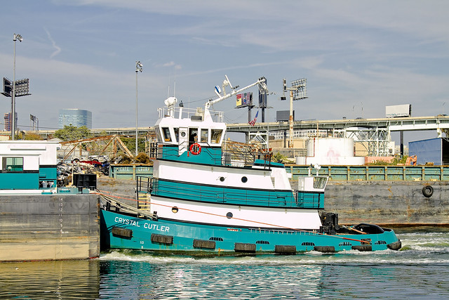
Built Nov. 04, 2010- this is the tugboat Crystal Cutler and her articulated barge (the Patricia E. Poling) plying the Newtown Creek. The article linked to below will tell you everything you could possibly ask about this tug and those who Captain and command her.
What mysteries they might have witnessed along the Creek, however, are not discussed in this profile.
The 70-foot, 1,500-hp twin-screw tug Crystal Cutler has been pushing and occasionally towing a 15,000-barrel clean oil barge since the tug was introduced in 2010. The tug places a high demand on her captains and crews as she ventures into shallow rivers and estuaries, moving about in a highly dynamic harbor with loads of gasoline, fuel additives or heating oil for small oil terminals.

– photo by Mitch Waxman
Amongst the larger harbor community, Newtown Creek is seldom referred to in glowing terms. There are those who dispute its role and historical significance to the maritime industry- as their eyes and hearts are drawn to the Brooklyn Navy Yard, the West Side of Manhattan, and the gargantuan modern ports in New Jersey.
Many would like to abandon it as an industrial corridor entirely, saying that its day as a working waterway is done, and give it over to kayaking and other recreational occupations.
Founded in 1995, Poling Cutler began operations near the time the former Poling Transportation went out of business.
The Founders of the new company were Ed Poling, whose grandfather started the former Poling company, and Gary Cutler who spent years working in the financial world before getting involved in Marine Transportation.
– photo by Mitch Waxman
One of the greatest sins along the Newtown Creek is precisely how few of its docks are utilized today. Most of the modern business along the Creek looks toward truck transportation to bring their goods to market and for the delivery of raw materials, ignoring their valuable docking rights and imprimature. Miles of bulkheads, expensively installed during prior generations, are allowed to rot away.
What a wasted opportunity.
Moving essential bulk materials by barge is more efficient economically and environmentally. From what we hear, a single barge has the same capacity as 28 – 56 long haul trucks, depending on the industry. Compared to other transportation modes, barge transport of bulk materials is safer in terms of worker injuries and generates far fewer emissions of particulate matter, hydrocarbons, carbon monoxide, CO2 and nitrous oxide on a per ton mile moved basis.
Despite the critical importance of barge transport as a best practice for industries on Newtown Creek, much of the bulkhead along this waterway is in disrepair. Overall bulkhead condition reveals a trend of disinvestment in maritime transit and a decline in related industries. According to Army Corps of Engineers, there were 19 businesses with working docks in 1999, compared to the nine that remain active today, as of January 2011.

– photo by Mitch Waxman
When you boil it down, the whole purpose of the Newtown Creek in its current form is to bring bulk goods into New York City by barge. Admittedly, the days of Standard Oil, Phelps Dodge, and the great Lumber interests are long gone- but… imagine some farmers in upstate New York loading their harvest goods onto a barge, and sending a floating green market directly to Long Island City or Greenpoint or even Maspeth. The barge could return to the farmer laden with cash and whatever else might be needed for the next harvest, completing a virtuous circle.
Imagine standing on the shoulders of giants, rather than rifling through their corpses like so many bugs.
from dot.ny.gov
Commercial and industrial development along Newtown Creek began circa 1854-60 and accelerated rapidly, spurred by low land values, water access for ships and boats, and relative remoteness from populated areas or regulations. The first kerosene refinery in the United States (1854) and modern oil refinery (1867) helped transform Newtown Creek into an industrial waterway. The first few industries also included a distillery near the Newtown side of the Penny Bridge, and the Peter Cooper glue factory relocated from elsewhere in Greenpoint to a site in Bushwick north of Maspeth Avenue10. The influx of industry and jobs, aggressive real estate development in and around Hunter’s Point, including LIRR’s presence on the creek in 1861, and the explosive growth of refined petroleum products all enhanced Newtown Creek’s attractions and helped transform the drainage into an industrial waterway circa 1860-1880. At the Industrial Revolution’s height, Newtown Creek’s industries were flourishing, bringing thousands of people to work at its plants and factories.

– photo by Mitch Waxman
The United States Coast Guard sometimes refers to Newtown Creek as part of “America’s Maritime Superhighway”, a vital industrial waterway which must be protected from the interests of those too short sighted to realize its potential to reinvigorate the economies of those communities through which it flows. It is the very definition of the future, and New York’s destiny is and has always been directly linked to it.
It’s heart warming to see clear eyed mariners like those onboard the Crystal Cutler plying its waters.
from nycppf.org
Significant Maritime and Industrial Area
Newtown Creek, at over 780 acres the city’s largest SMIA, abuts portions of the Greenpoint, Williamsburg, Long Island City, and Maspeth industrial areas. The waterfront area is characterized by heavy industry and municipal facilities, many of which are water- dependent. Newtown Creek is also the largest SMIA in terms of employment.
Although from 1992 to 2008 the SMIA lost roughly half its jobs, from 2000 to 2008 the number of jobs in the SMIA grew by nearly 1,400 to reach a total of approximately 15,000 jobs. Nearly half of the jobs in 2008 were in transportation and warehousing and wholesale trade. However, the business mix is becoming much more diverse. In the eight-year period examined, non-industrial jobs grew by more than 35 percent.
social upheaval

– photo by Mitch Waxman
Holy smokes! Two enormous lots, formerly bisected by an abandoned railway line sweeping across the entire lot, found between the Dutch Kills tributary of the Newtown Creek and 30th street to the west and east and between Borden and Hunters Point Avenues to the south and north, have been entirely razed. The Hunters Point Avenue side, until recently, held the plant of “National Envelope” and the other has been vacant for quite some time.

– photo by Mitch Waxman
This must be the first time in almost a hundred years that this point of view has been available from Borden Avenue, a wide open vista showing the Degnon Terminal- or at least the survivors of it- that stretches all the way to Queens Plaza. Incidentally, the dust that this project is kicking out is massive, and the day these shots were obtained- was heading in a westerly direction toward the recently repopulated neighborhood of Hunters Point commonly referred to as Long Island City.
Upon observing this, I made it a point to stay upwind of the dust plume.

– photo by Mitch Waxman
I’m told that the next incarnation of this site along Dutch Kills will be a Federal Express shipping center, which will be enormous if the entire footprint of this site is used. That’s going to be a LOT of trucks coming and going through this ancient neighborhood and Western Queens in general.
Let’s hope that the century old bridges on Borden and Hunters Point Avenue can handle the additional load.
Wonder how the large shipments of bulk freight coming from the airports will travel here, or how the hundreds of local delivery Fed-Ex trucks will get to Manhattan, and North Brooklyn, and Eastern Queens- by which routes they will travel, and through whose neighborhoods?
ALSO, this Friday, as in tonight:

My own attempt at presenting a cogent narrative and historical journey “up the creek” is up coming as well-
Your humble narrator will be narrating humbly on Friday, February 24th at 7:30 P.M. for the“Ridgewood Democratic Club, 60-70 Putnam Avenue, Ridgewood, NY 11385” as the “Newtown Creek Magic Lantern Show” is presented to their esteemed group. The club hosts a public meeting, with guests and neighbors welcome, and say that refreshments will be served.
The “Magic Lantern Show” is actually a slideshow, packed with informative text and graphics, wherein we approach and explore the entire Newtown Creek. Every tributary, bridge, and significant spot are examined and illustrated with photography. This virtual tour will be augmented by personal observation and recollection by yours truly, with a question and answer period following.
For those of you who might have seen it last year, the presentation has been streamlined, augmented with new views, and updated with some of the emerging stories about Newtown Creek which have been exclusively reported on at this- your Newtown Pentacle.
For more information, please contact me here.
What: Newtown Creek Magic Lantern Show
When: Friday, February 24th at 7:30 P.M.
Where: Ridgewood Democratic Club, 60-70 Putnam Avenue, Ridgewood, NY 11385


 The Newtown Pentacle