Posts Tagged ‘photowalk’
the sullen shore

– photo by Mitch Waxman
One such as myself is addled by detail and lost in the phantasmagoria of history, an unending torrent of dates and numbers. The “historians” of the world pride themselves on being able to pull such numerals out of a memorized hat, reciting them in the same manner that a rabid sports fan might describe the statistics of their favorite team. On some topics I can accomplish this, but as long time readers will attest- my brain works a bit differently than most.
To me, it’s the story that counts.
from wikipedia
This bridge and the Manhattan Bridge are the only suspension bridges in New York City that still carry both automobile and rail traffic. In addition to this two-track rail line, connecting the New York City Subway’s BMT Nassau Street Line and BMT Jamaica Line, there were once two sets of trolley tracks.
The Brooklyn landing is between Grand Street and Broadway, which both had ferries at the time. The five ferry routes operated from these landings withered and went out of business by 1908.
The bridge has been under reconstruction since the 1980s, largely to repair damage caused by decades of deferred maintenance. The bridge was completely shut down to motor vehicle traffic and subway trains on April 12, 1988 after inspectors discovered severe corrosion in a floor beam. The cast iron stairway on the Manhattan side, and the steep ramp from Driggs Avenue on the Williamsburg side to the footwalks, were replaced to allow handicapped access in the 1990s.

– photo by Mitch Waxman
Mathematics has always been my particular failing, its abstractions and dry logic have always evaded me. During second grade, I had the pox upon me, and missed the introduction to long division- an illness with long term consequence as I’ve never really caught up. Often, I think that I suffer from some sort of numbers based form of dyslexia, which is as close as can be described to what happens to numerals as they swirl about in my head.
The calendrical information is far less important than “the story”. It’s best to refer to careful notes on minor details like day and year, and critical to commit context and theme to memory.
from Mayor Low’s administration in New York By City Club of New York, 1903, courtesy google books
The general plan of the bridge was adjopted by the East River bridge commission on August 19th, 1896, and filed in the department of public works of each of the two cities. In May, 1897, an amended plan was adopted and filed. The first actual work on the bridge was begun on the Manhattan tower foundation on October 28th, 1896.
The tower foundations on both sides of the river rest on solid rock. The north pier on the Manhattan side sinks to a depth of 56 feet below high water and the south pier 66 feet below high water. On the Brooklyn side the north pier extends to a maximum depth of about 101 feet below high water and the south pier to a maximum depth of about 90 feet below high water. The Manhattan anchorage rests on 3,500 piles driven through clay to a bed of sand overlying the rock. The Brooklyn anchorage rests on natural sand.
 \
\
– photo by Mitch Waxman
Is it important to know what day the Williamsburg Bridge was erected, as compared to the tales of those early shipwrights, dry docks, and vast maritime complexes which it obliterated?
To me, it is far more interesting to chew on the fact that the massive shipyards, which included Novelty Iron works, between here and Corlears Hook spawned a lost and forgotten world amongst the wharves and birthed a unique culture whose hidden influence affects our world to this day..
For instance-
- Legend has it that there were once so many ladies of the evening around Corlears Hook, servicing the sailors and working men employed at these yards, that the slang term “hookers” became ubiquitous with prostitution.
- The earliest institutional ancestors of the the NYPD, addressed with the task of cleaning up the neighborhood, were forbidden to wear uniforms by State Law and would instead identify themselves as Police by displaying a six pointed badge made of copper- which is why we call them “Cops” to this day.
also from wikipedia
In 1638 the Dutch West India Company first purchased the area’s land from the local Native Americans. In 1661, the company chartered the Town of Boswijck, including land that would later become Williamsburg. After the English takeover of New Netherland in 1664, the town’s name was anglicized to Bushwick. During colonial times, villagers called the area “Bushwick Shore.” This name lasted for about 140 years. Bushwick Shore was cut off from the other villages in Bushwick by Bushwick Creek to the north and by Cripplebush, a region of thick, boggy shrub land which extended from Wallabout Creek to Newtown Creek, to the south and east. Bushwick residents called Bushwick Shore “the Strand.” Farmers and gardeners from the other Bushwick villages sent their goods to Bushwick Shore to be ferried across the East River to New York City for sale via a market at present day Grand Street. Bushwick Shore’s favorable location close to New York City led to the creation of several farming developments. In 1802, real estate speculator Richard M. Woodhull acquired 13 acres (53,000 m²) near what would become Metropolitan Avenue, then North 2nd Street. He had Colonel Jonathan Williams, a U.S. Engineer, survey the property, and named it Williamsburgh (with an h at the end) in his honor. Originally a 13-acre (53,000 m2) development within Bushwick Shore, Williamsburg rapidly expanded during the first half of the nineteenth century and eventually seceded from Bushwick and formed its own independent city.
Project Firebox 44

– photo by Mitch Waxman
One would normally wax rhapsodic about this specimen found on Northern Blvd. at the foot of the Honeywell Street Bridge, but unfortunately, good old Time Warner Cable is up to their usual tricks tonight and connectivity to the Pentacle is sporadic at best. I’m not sure how long this window will be open. Be back tomorrow, hopefully.
form or matter

– photo by Mitch Waxman
Gaze in bewilderment upon the under cobbled lanes of fabled Astoria, hoary and venerable, one of the last locations within the megalopolis which actually resembles New York City. The human infestation is dense here, where an effervescent melange of cultures nevertheless vies to ignore each others presence. Many of my neighbors have told tall tales of “back home”, all of which are unsavory to my American ears. The wonder of this place is that the cultural stressors which tear and gnash have more to do with parking spots and loud music than centuries old blood feuds and the inheritances of Eurasian nationalism.
People in Astoria pride themselves on minding their own business, which has become kind of an issue of late.
from wikipedia
A blood feud is a feud with a cycle of retaliatory violence, with the relatives of someone who has been killed or otherwise wronged or dishonored seeking vengeance by killing or otherwise physically punishing the culprits or their relatives. Historically, the word vendetta has been used to mean a blood feud. The word is Italian, and originates from the Latin vindicta (vengeance). In modern times, the word is sometimes extended to mean any other long-standing feud, not necessarily involving bloodshed. Sometimes, it is not mutual but a prolonged series of hostile acts waged by one person against another without reciprocation.

– photo by Mitch Waxman
Do not mistake the place for a paradise, nor blankly accept the soporific descriptions of Astoria offered by Real Estate Industrial Complex operatives or the political class. One cannot ignore the omnipresent darkness which emerges in the ancient village. Just down my block, a couple of summers ago, an old man died in his house at the height of summer and his mouldering corpse lay undiscovered for several weeks- the explosive result forced a tear down renovation of his living quarters- an expense which forced his landlord to sell the building. Another neighbor, suffering from severe depression, attempted suicide via hanging several years ago. He was clinically dead when the paramedics arrived, but resuscitated. Unfortunately, other members of his creed, adherents to ancient superstition, believe him to be animated by the devil itself and shun him. “The Man with no Soul”, as he is called, wanders the neighborhood blankly and brain damaged.
Also, there is the odd fat man on 34th avenue and his criminal army of juvenile devotees…
from wikipedia
A nachzehrer is created most commonly after suicide, and sometimes from an accidental death. According to German lore, you don’t become one from being bitten, or scratched. It is just something that happens. Nachzehrers are also related to sickness and disease. If a large group of people died of the plague, the first person to have died is believed to be a nachzehrer.
Typically a Nachzehrer devours its family members upon waking. Its also been said that they devour themselves, including their funeral shroud, and the more of themselves they eat, the more of their family they physically drain. It is not unlikely that the idea of the dead eating themselves might have risen from bodies in open graves who had been partly eaten by scavengers like rats.
Some Kashubes believed that the Nachzehrer would leave its grave, shapeshifting into the form of a pig, and pay a visit to their family members to feast on their blood. In addition, the Nachzehrer was able to ascend to a church belfry to ring the bells, bringing death to anyone who hears them. Another lesser known ability of the Nachzehrer is the power it had to bring death by causing its shadow to fall upon someone. Those hunting the Nachzehrer in the graveyard would listen for grunting sounds that it would make while it munched on its grave clothes.

– photo by Mitch Waxman
Brutal homicides and bizarre occurrences permeate the recent past here- on the corner pictured above, there was a gun battle and fatal shooting just last year. An uptick in public drunkenness, petty vandalism, and large groups of carousing youths has been commented on more than once by area wags in recent months. Disturbingly, the social contract seems so tattered that public defecation and urination are now the norm on Broadway, despite the easy availability of lavatories at any number of bars and restaurants. As is the way with Queens, many complain, but few step forward to confront and chase away the chaos.
They shrug, and accept, and forget all about Kitty Genovese.
from wikipedia
Catherine Susan “Kitty” Genovese (July 7, 1935 – March 13, 1964) was a New York City woman who was stabbed to death near her home in the Kew Gardens neighborhood of the borough of Queens in New York City, on March 13, 1964.
The circumstances of her murder and the lack of reaction of numerous neighbors were reported by a newspaper article published two weeks later; the common portrayal of neighbors being fully aware but completely nonresponsive has since been criticized as inaccurate. Nonetheless, it prompted investigation into the social psychological phenomenon that has become known as the bystander effect or “Genovese syndrome” and especially diffusion of responsibility.
obscure world

– photo by Mitch Waxman
As described in prior postings, 58th road and Maspeth Avenue were once connected by a plank road which last crossed the Newtown Creek in 1875 and which was established as early as the 1830’s. What’s important about this is that the street grid in this spot hasn’t appreciably changed since the late 19th century, and it’s one of the few places around the creek where maps require little or no “interpretation”. That’s the Maspeth Avenue side pictured above.
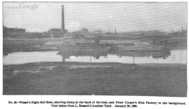
– photo from 1896’s Report By Brooklyn (New York, N.Y.). Dept. of Health, Brooklyn (New York, N.Y.). Health Board, courtesy google books
One of those little nuggets which has fascinated me since beginning to learn about the Creek has been references to “Conrad Wissel’s Dead Animal Wharf” or alternately “night soil dock”. Imagine my surprise when I found a photo of the place from 1896 the other night. In the far left corner of the frame, you can just make out the Maspeth Avenue Plank Road. Wo!
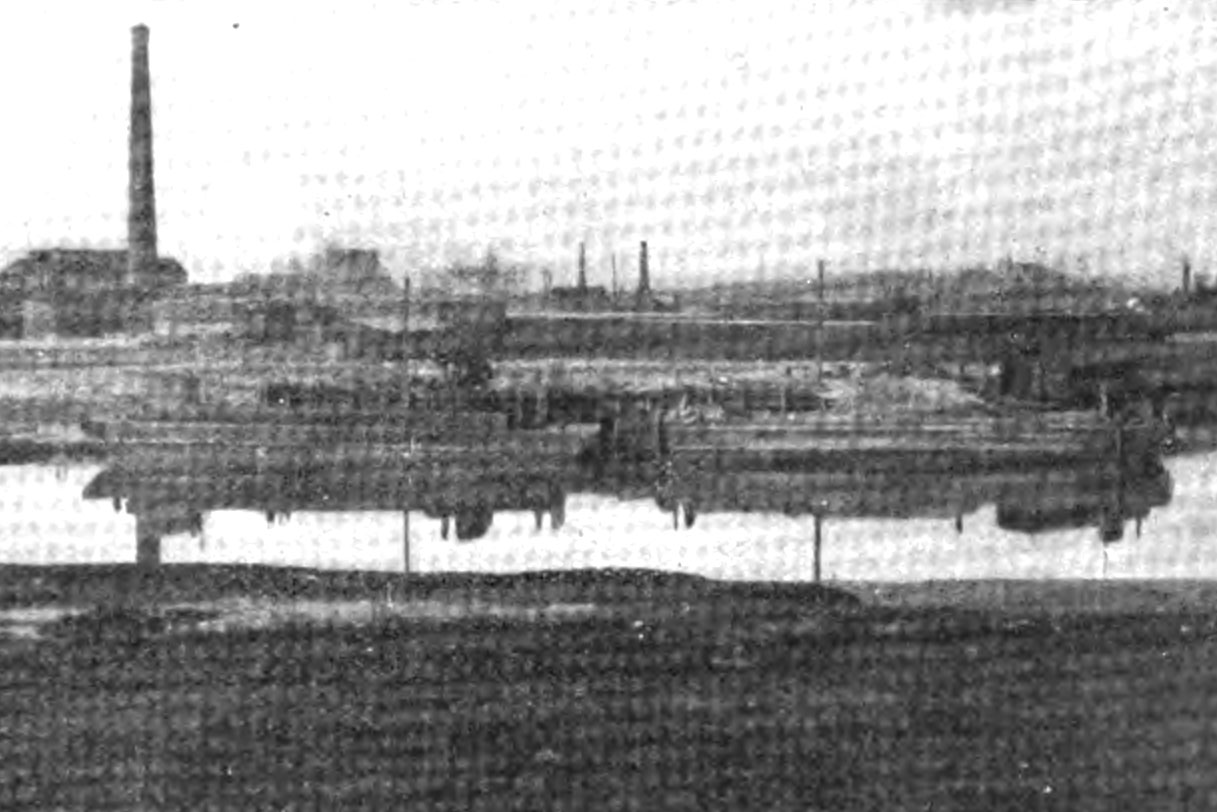
– photo from 1896’s Report By Brooklyn (New York, N.Y.). Dept. of Health, Brooklyn (New York, N.Y.). Health Board, courtesy google books
A little photoshopping has been applied here, improving contrast and attempting to remove some of the moire in google books’s scan of the original.
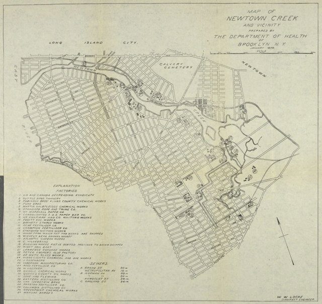
– map from 1896’s Report By Brooklyn (New York, N.Y.). Dept. of Health, Brooklyn (New York, N.Y.). Health Board, courtesy digitalgallery.nypl.org
The NY Public Library hosts the image above, which is the map that was included in the volume that the photo originates in. Click the image to access a zoom able version, whose key lists the Wissel’s dock as number 16.
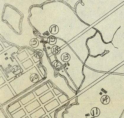
– map from 1896’s Report By Brooklyn (New York, N.Y.). Dept. of Health, Brooklyn (New York, N.Y.). Health Board, courtesy digitalgallery.nypl.org
In this detail from the map, number 16 is clearly just west of the Maspeth Avenue Street end. That’s one mystery solved.

– photo by Mitch Waxman
Here’s another view in modern times, the Wissel property would be just starting on the right side of the frame. The shot is from the Queens side, of course, as is the original- and captured at approximately where the “18” is on the detail of the map. The 1896 photographer would have standing around 500 feet to the right of this vantage point.
The Smelling Committee

– photo by Mitch Waxman
As long time readers will recall, in the fall of 2010, the Newtown Creek Alliance and the Working Harbor Committee received a grant from the NYCEF fund of the Hudson River Foundation to conduct 4 boat tours of Newtown Creek. The plan was to do two ticketed tours for the public (the tickets were available at a steeply discounted rate), one for educators, and one for “the elected’s” of the watershed. The first three went off without a hitch, but the fourth was postponed due to the tragic helicopter crash on the East River which occurred just as we were about to board the boat.
Last Friday, the 4th of May, we accomplished the fourth tour with a modern day “Smelling Committee” onboard.
from “Annual Report of the Department of Health of the City of Brooklyn for the year 1895”, courtesy google books
Whereas, Complaint has been made to the Governor of the State of New York during the year 1894 by the citizens and residents of the Town of Newtown and the City of Brooklyn, relating to the existence of public nuisances on or near Newtown Creek, jeopardizing the health and comfort of the people in the vicinity thereof, and the Hon. Roswell P. Flower, Governor of the State of New York, did thereupon, on the 2d day of August, 1894, pursuant to Chapter 661, of the Laws of 1893, require, order and direct the State Board of Health to examine into the alleged nuiscances, and to report the result thereof…

– photo by Mitch Waxman
Important to the mission was attendance of officials from both sides of the Creek. The “center of gravity” for the advocacy of the Newtown Creek has historically been in Greenpoint, but that doesn’t mean that the folks on the Queens side haven’t been paying attention. Pictured above are Michael Gianaris and Jimmy Van Bramer, and both were anxious to visit this hidden part of their districts.

– photo by Mitch Waxman
As luck would have it, we passed by one of the many workboats which have been operating along the Newtown Creek of late. These workboats, hailing from Millers Launch on Staten Island, are carrying contractors and employees of the Federal Environmental Protection Agency who are collecting samples of the so called “black mayonnaise” sediments for laboratory analysis.

– photo by Mitch Waxman
You cannot fix something unless you understand it, and the EPA has scheduled an exhaustive “scoping period” during which a series of such tests will be performed. Since January, I have personally witnessed dozens of such operations- ranging from towing a sonar buoy up and down the waterway to establish a subsurface topographical map, to the group onboard this vessel who seemed to operating a hand operated dredge to bring materials up into the light.
Notice that the folks directly handling the sediments are wearing protective garments.

– photo by Mitch Waxman
A Newtown Creek Alliance member, Phillip Musegaas of Riverkeeper fame came along to inform about and describe the legal and policy issues surrounding the Greenpoint Oil Spill, Superfund, or any of the myriad points of law which surround the Newtown Creek. That’s Phillip on the right.
I should mention that Council Member Stephen Levin of Greenpoint was onboard as well, but was forced to stay in the cabin and deal with urgent business in his district via phone.

– photo by Mitch Waxman
A decision which I’ve been keeping to is to not bring “civilians” all the way back to English Kills on these boat tours, but this “Smelling Committee” was no mere interested group and accordingly we entered into the heart of darkness- God’s Gift to Pain itself. This is as bad as it gets along the Newtown Creek, a stinking and fetid miasma poisoned with sewage and urban runoff surrounded by waste transfer stations.
In the distance is one of the largest CSO’s in the entire city, and the Montrose Avenue Rail Bridge of the LIRR’s Bushwick Branch.

– photo by Mitch Waxman
Not just elected officials were onboard, of course, representatives of a veritable alphabet soup of three lettered agencies were also invited. Additionally, local leaders- such as Tom Bornemann from the Ridgewood Democratic Club (pictured above, in sunglasses) accompanied the tour. The microphone was passed amongst us, with Kate Zidar (NCA’s executive director), Michael Heimbinder (NCA’s chair), Laura Hoffman (Newtown Creek Monitoring Committee), Phillip Musegaas (Riverkeeper), Penny Lee (City Planning), and myself narrating at various legs of the trip.

– photo by Mitch Waxman
Pictured above are Assemblyman Joe Lentol of Greenpoint, Council Member Jimmy Van Bramer of Queens, Working Harbor Development Director Meg Black, Council Member Diana Reyna of Brooklyn, a gentleman who I’m embarrassed to say I can’t identify, and State Senator Michael Gianaris.

– photo by Mitch Waxman
The Smelling Committee of 2012 encountered a Newtown Creek swollen by days of rain, replete with oil slicks and “floatables” contamination. The term floatables is used to describe everything from stray bits of lumber and tree limbs to cast off plastic bottles and wind blown trash carried in the water, by the way. The trip was 2 hours in length, and accomplished onboard a NY Water Taxi vessel. It left from Pier 17 in Manahattan at four in the afternoon and returned at six, proceeding some three and one half miles into the Newtown Creek and required the opening of the Metropolitan Avenue Bridge.

– photo by Mitch Waxman
Along the way, sites of legal or popular interest were pointed out- including the future of the Arch Street Yard, the Hunters Point South development, SimsMetal, the Newtown Creek Waste Water Treatment Plant, the Greenpoint petroleum district, the Blissville Oil spill, the Greenpoint Oil Spill, the Phelps Dodge site, the Kosciuszko Bridge, the CSO issue, the role of Newtown Creek as a mass employer, the maritime potential of the Creek and its potential for eliminating a significant amount of trucking activity, its myriad waste transfer stations, and the plans which EPA have for the place.

– photo by Mitch Waxman
Crass observers in the antiquarian community and political operatives in both boroughs will sneer at efforts such as this, the aim of which was to create a common sense of purpose and to identify issues regarding the Creek for both the Queens and Brooklyn political establishments. Ridgewood and Bushwick, Maspeth and Greenpoint, Williamsburg and Long Island City- all parts of the Newtown Creek watershed have more in common with each other than they do with neighboring districts in either borough. They are blessed with one of the finest industrial waterfronts in the world, but cursed by its past. What the Newtown Creek will look like in fifty years time is beginning to be discussed, and it was time for this “congress of the creek” to be convened.
So much of what the people in high office know of this place is influenced by dire reportage and dry testimony, and it can be easy to overlook the past, present, and future of this maritime superhighway if you haven’t experienced it first hand.
Especially from the water.

– photo by Mitch Waxman
Several times have I witnessed the effect that this place has on first time visitors, a transformation of expression and demeanor overtakes them.
Hardened New Yorkers all, the Newtown Creek nevertheless explodes all expectations and an expression of wonderment forms upon their faces. They come to see toxic waste dumps and oil spills, but instead find Herons, Egrets, and Cormorants nesting in the broken cement of abandoned industrial bulkheads. They witness the miles wide vistas and wide open view of the City of New York from its very navel, and are thunderstruck that such a place exists- this “Insalubrious Valley” of the Newtown Creek watershed.
Every time I start to narrate on one of these tours, my first utterance is always “this is not the world you know…”.
I’m happy to say that due to the Working Harbor Committee, Newtown Creek Alliance, and the NYCEF Fund of the Hudson River Foundation- the Smelling Committee of 2012 knows this corner of the world a little bit better.
What will come of it?
Others will have to answer that, for your humble narrator must remain without and is cursed to merely observe such matters. Always, an outsider.


