Posts Tagged ‘Pickman’
searing gusts

– photo by Mitch Waxman
That which does not think nor breathe yet instead hungers, a malign intelligence which cannot possibly exist yet nevertheless stares down upon the world of men from the apex of the Megalith, sits upon what can only be called a Hlidskjalf.
Odin had one, a chair set upon the highest peak from which he would dispatch his all seeing ravens- Huginn and Muninn– to spy upon men and report tales of mortal vanity and sin back to his “high seat”.

– photo by Mitch Waxman
A feverish and singular eye gazes down from its sapphire high seat, its vantage affording it the 53rd highest point of view available in New York City.
Your humble narrator maintains a vast cadre of whistle blowers, neighborhood cranks, idle laborers, low level government workers, and casual informants in the prosecution of this blog. Reports returned from this network who have witnessed the tableau laid before them from atop floors of the Megalith are tantalizing.
One might see the Battery and Hell Gate, Brooklyn’s East River and its Jamaica Bay coastlines, and every bridge to Manhattan for the price of turning ones head from up there- or so I am told.

– photo by Mitch Waxman
That behemoth which cannot possibly lurk there, squatting diabolically atop the highest point on Long Island as it searches the land below for rapacious profit, what can it know about the human world it gazes upon? Can it understand individuality, and environment, or does it just see numbers?
Were such an impossibility to exist, would it believe itself to be some sort of god as Odin did- an undying and omnipresent entity served globally by a growing and humorless army of mortal acolytes?

– photo by Mitch Waxman
All this is idle speculation, of course?
little memories

– photo by Mitch Waxman
What you’re looking at used to be one of the centers of the world, the Long Island Railroad terminus at 2nd street and Borden Avenue. The original version of the place was built in 1861 and provided egress to Manhattan via an enormous ferry terminal which shuttled commuters back and forth across the East River. This was (and is) the literal “End of the Line”.

– photo by Mitch Waxman
The station was electrified (WRONG, Sharp Eyed Reader “Kevin” points out that these are diesel trains) along with the rest of the LIRR western spurs, when the tunnels to Manhattan were opened in the early 20th century. The tunnels allowed direct transport to Penn Station, eliminating those delays associated with weather which plagued the ferry service.
Today, excess capacity during the slack time between rush hours can be found idling on the tracks on any given day.

– photo by Mitch Waxman
Several versions of the station have been installed here- for instance, a calamitous fire in 1902 destroyed the wooden buildings and train sheds which distinguished the place in the late 19th century. A trip to the acknowledged masters on the subject- the website arrts-arrchives.com is recommended for the curious.
revel and chaff

– photo by Mitch Waxman
As soon as the rain died down, I descended from Newtown Pentacle HQ here in the rolling hillocks of Astoria to the so called “Zone A” to see what Irene might have wrought here in western Queens. The shot above is from Second Street near Borden Avenue, at the largish worksite which Skanska has been employing hundreds for the last few months. Cleverly, the construction giant had dug a diversion ditch to allow storm water drainage.
Smart.

– photo by Mitch Waxman
“There will be plenty of cameras walking around in Tower Town, so it would be silly of me to spend much time there” were the actual words spoken to my walking companion, who we’ll call the Charismatic Croat (CC). CC was also told that we’d be taking a short walk, and would be back in a half hour. He’s used to my lies and wasn’t surprised when we had inexorably headed for another part of “Zone A”.
All through the storm, I was wishing that I had the camera out at Newtown Creek, or at least Dutch Kills.

– photo by Mitch Waxman
Curiosity about the actions of the much feared storm surge upon the fragile bulkheads of Dutch Kills was killing this cat, and I dragged CC back and forth over these streets. There was some flooding, but in the usual places that flood anyway. Back on 2nd street, a few nice shots of the surge were captured by Jesse Winter and others, and an actual wave of East River had risen up and flooded 2nd. The Crab House was bailing water from their basement and more than one giant puddle still remained.
Down at Dutch Kills, 29th street and the large truck yard which houses this cement company were under a foot or more of water- but they are regularly immersed by small amounts of rain anyway.

– photo by Mitch Waxman
What made the day noteworthy, from a Newtown Creek point of view, was this little river of urban chocolate flowing out of one of the many CSO’s (Combined Sewer Outfall) which are found abundantly along the waterfront of the Creek and it’s tributaries. It smelled just the way it looks like it might. One often sees discharges coming from these CSO’s, but this was just a spectacular flow.

– photo by Mitch Waxman
I will point out that this could be soil washed into the pipes during the tremendous amount of rain which Irene brought to Queens. It could be sand or actually be a chocolate spill at some industrial confectionary which got washed into the sewers or something. That’s what I said to CC at the time.
Doesn’t smell like chocolate, the Charismatic Croat opined.
Happy Birthday, Kosciuszko Bridge

– photo by Mitch Waxman
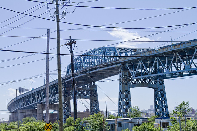
A virtual guarantee is offered that this is the only posting you will see today commemorating and wishing the Kosciuszko Bridge a happy 72nd birthday. Some 26,298 days ago, Robert Moses saw the first link in a crazy idea of his which would one day be called the “Brooklyn Queens Connecting Highway” open for business.

– photo by Mitch Waxman
The Meeker Avenue Bridge opened on August 23rd, 1939 (renamed in 1940 as The Kosciuszko Bridge) – some 631, 152 hours ago. It was promised to allow easy egress to the World’s Fair, and was a showpiece project for the Great Builder.

– photo by Mitch Waxman
From a Newtown Pentacle posting of December 8, 2010– in which the big K was described as thrice damned:
Damned Once- The Kosciuszko Bridge catches radio frequency emissions from several nearby commercial radio broadcast antennas. A lot of it.
Whatever knows fear burns at The Kosciuszko Bridge’s touch.
Damned Twice- The Kosciuszko Bridge is at extreme risk in the eventuality of a seismic event. The Brooklyn pier actually sits on the Creek bed, some 6 meters below grade, but the Queens side is anchored on piles driven into the mud. The hard soil around Queens Plaza will merely shake, but the land surrounding the Newtown Creek will liquify.
Damned Thrice- The Kosciuszko Bridge once had pedestrian walkways, but they were removed in 1961. Can you imagine what kind of photos would be possible on a pedestrian walkway 124 feet over the Newtown Creek?
– photo by Mitch Waxman
Like many things and people who are 72 years old, the Kosciuszko Bridge is not long for this world. Why not raise a glass to it tonight, and acknowledge its long service to the City?
Click here for a sentimental slideshow of the old girl from the last couple of years
another aperture

– photo by Mitch Waxman
An aerial shot from the former Loose Wiles biscuit factory (and modern day LaGuardia Community College) which shows the totality of the Dutch Kills turning basin and the properties which surround it. Special notice of the cement factory and the red white and blue self storage warehouse should be taken, and the Hunters Point Avenue Bridge and Long Island Expressway (just above center) which were described in earlier posts are also pointed out. Additionally, notice the two sunken barges in the lower left hand corner of the shot.
click for parts one, two, and three of this trip down Dutch Kills. This is the last of the four postings describing what I saw at Dutch Kills while on a Newtown Creek Alliance assignment.

– photo by Mitch Waxman
The stated mission of this exhibition was to catalog and photograph the little known bulkheads and shorelines of Newtown Creek and it’s various tributaries, and NCA had arranged for Riverkeeper to ferry us back and forth across the troubled waterway. Troubled is a politically correct way of describing the Newtown Creek watershed which native New Yorkers would translate into local patois as “all ‘effed up”, or which a military man would call “FUBAR”.

– photo by Mitch Waxman
Risible, the state of decay along these shorelines is startling. Dutch Kills has been largely abandoned by maritime interests, despite its once proud role as the central artery of the industrial complex called the Degnon Terminal. The corrosive affect of estuarine water upon cement and underlying steel has rotted away the manmade shorelines and bulkheads, carving away the efforts and labor of whole generations.

– photo by Mitch Waxman
There is no reason to say the name of the corporation which occupies the red, white, and blue self storage warehouse which sits above these pilings. It is immaterial to adjure any organization in Queens, whether it be governmental or corporate, for no one cares. It is remarkable, though, that the corrosive action of the waters of Dutch Kills have so undermined the foundations of this structure that grottoes have formed amongst its pilings.

– photo by Mitch Waxman
Remember, this was swamp land as late as the first decade of the 19th century. When Degnon’s people began their work here, at the Waste Meadows, there was barely any solid land between Hunters Point and Blissville. The LIRR, of course, had built their tracks sturdily and have no doubt that Standard Oil had engineered their grounds with proper drainage and stout foundations- but the inland path along Dutch Kills was nearly worthless.

– photo by Mitch Waxman
Degnon owned a construction company which was capable of doing the impossible, and his people had a special affinity for problems involving water. They made their name during the construction of the second East River (or Williamsburg) Bridge, were involved in the taming of the Wallabout Creek, and had recently been engaged by the newly consolidated City of Greater New York to complete the rail tunnels which would link Queens to Manhattan via the novel new Subway system. Those tunnels excavated a large amount of spoils and borings, which would be used to create the very ground around Dutch Kills as “landfill”.
By the first decade of the 20th century, enough compacted landfill was here to begin pouring concrete slabs, and upon those slabs the Degnon Terminal rose.

– photo by Mitch Waxman
This post will not cover the entire story of the Degnon Terminal. I would refer you to trainsarefun.com, and forgotten-ny for facets of the story, or suggest a visit to the Greater Astoria Historical Society for an attempt to get them to share their expertise on the subject. The tale of Michael Degnon is the stuff of scholarly dissertation. Degnon is buried in Calvary cemetery, and I suspect he rests uneasily because of what lesser men have done to his legacy.
There are two sunken fuel barges here, rusting away into history.

– photo by Mitch Waxman
Pictured above is the CSO Outfall BB-026 which vomits untreated storm water and sewage into Dutch Kills regularly, and it is one of the primary sources of water flowing into Dutch Kills. The boat began moving in a counter clockwise fashion at this point, swinging away from the 29th street address of the red, white, and blue self storage warehouse and toward the concrete factory.

– photo by Mitch Waxman
I’m unfamiliar with the role and identity of the two large pipes which are found beneath the concrete facility. The enormous slab of cement the factory is situated upon was once a rail switch, where short trip rail engines would await incoming barges. Once unloaded, these short trains would make deliveries to the industrial concerns which surrounded Dutch Kills.
Apparently, no small amount of conflict has arisen between the concrete company and environmental watchdogs over the years, but your humble narrator makes it a point of staying out of this sort of thing.

– photo by Mitch Waxman
The concrete industry around Newtown Creek often has fingers pointed at it, but again, large industrial concerns need to be sited “somewhere” to serve the interests of Real Estate and construction. The goal of many, including myself, is to ensure that in the days following the EPA Superfund cleanup of the Creeklands is that industry still feels welcome here. White collar corporate jobs are not an option for many, which is something often forgotten by those who spend their days in air conditioned Manhattan offices imagining the future of Queens.
These dirty industries must be compelled to “clean up their act” but cannot be regulated out of business.

– photo by Mitch Waxman
The boat turned away from the north eastern bulkheads of the Dutch Kills Turning Basin and we explored the bulkheads of the southern abutment. Again, the waters had carved into the underpinnings of the engineered ground. More abscesses and grottoes were observed cut into the cement and the visible wood seemed spongy and softened from the action of unknowable forms of microscopic life.

– photo by Mitch Waxman
I had to “bust a move” to conquer the deep shadows of early morning light here, as the merciless and burning thermonuclear eye of god itself was shining down unoccluded by cloud or atmosphere at this point. An external flash was attached to my trusty camera, which was “bounced” off the water. Anomalously, the green water created orange and red shadows in the reflected bursting of light.

– photo by Mitch Waxman
The Riverkeeper Captain who acted as our boatswain, John Lipscomb, checked his watch and announced that we had to beat a hasty retreat as the tidal actions of the East River would soon cause Dutch Kills to rise. Fearing that we might be trapped in Dutch Kills for a long interval, and having completed only a tiny fraction of our mission, Captain Lipscomb set course for the larger vessel which had launched our tiny “Tin Boat” which was docked at Whale Creek.

– photo by Mitch Waxman
The physical effects of the air and environment here were enormous, but the effort and risk of the journey were worth undertaking. Long have I desired to see Dutch Kills from water level, and to see the place as few others have.


