Posts Tagged ‘queens’
unequal heating
Creek Week concludes, in today’s post.
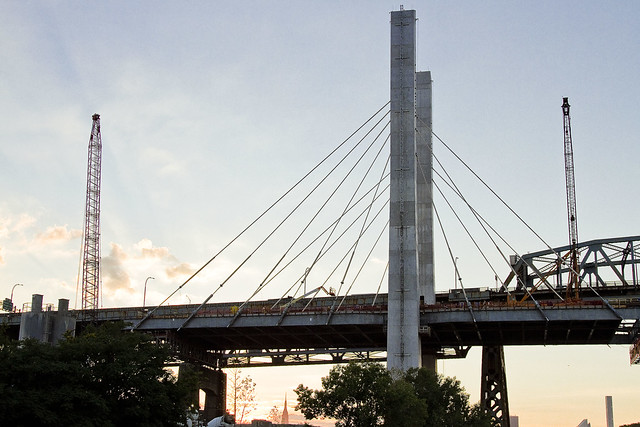
– photo by Mitch Waxman
That’s the Kosciuszcko Bridge replacement project pictured above, with the 1939 Robert Moses model bridge providing a backdrop to the under construction cable stay model. That’s the Brooklyn side, for the curious. This is a $1.2 billion replacement effort, “fast tracked” by Governor Cuomo, which is intended to replace what’s considered to be the most dangerous bridge in New York State – which happens to carry hundreds of thousands of vehicle trips a day as the Brooklyn Queens Expressway runs across its 2.1 mile long structure (along with its approaches).
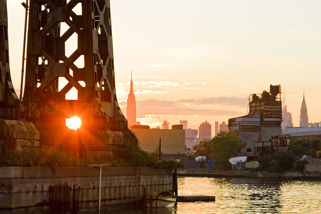
– photo by Mitch Waxman
These shots were captured while onboard a NY Water Taxi hired for the evening by the Open House NY organization, and my colleague T. Willis Elkins and I were onboard to represent Newtown Creek Alliance and narrate to two sold out crowds. The second trip was heading back out from the Newtown Creek towards the East River just as sunset was occurring, and as always – Newtown Creek was and is a visual spectacular.
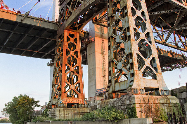
– photo by Mitch Waxman
One has been trying to capture as many angles and shots as possible of the old Kosciuszcko Bridge for a couple of years now, simply because within the next 24-36 months it will have been eradicated from common memory.
This whole “Newtown Creek Historian” business isn’t just about revealing the past, it’s about leaving behind a visual record for those who haven’t been born yet about what the place looked like during its superfund and early 21st century transformational period.
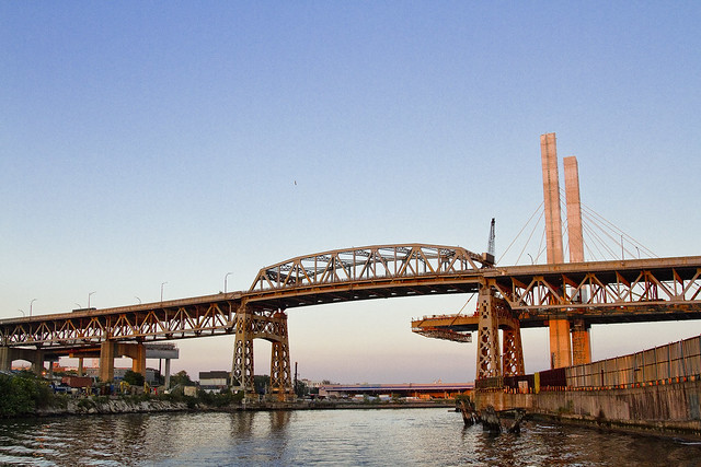
– photo by Mitch Waxman
I’ve mentioned it before, but the plan which the State DOT has put forward is that once the eastern side of the new bridge is complete, they are going to reroute the BQE onto it. Then, they’re going to demolish the 1939 model, and in its footprint, build the western section of the new cable stay bridge. The great news about that is that there is going to be a pedestrian and bicycle path on the western side of the bridge.
One looks forward to walking the camera across, and getting aerial shots from up there.
– photo by Mitch Waxman
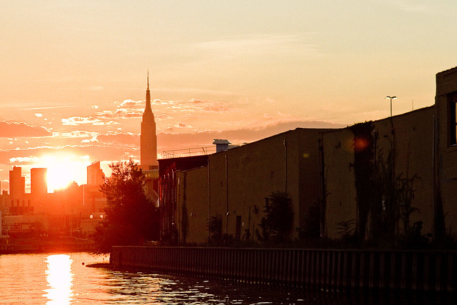
The burning thermonuclear eye of God itself was setting in the west as our NY Water Taxi navigated back towards the East River. That’s Blissville in Queens on the right hand side of the shot above, and the former location of not just Charles Pratt’s “Queens County Oil Works” but just about the very spot where the first large scale oil refinery in the United States – Abraham Gesner’s “North American Kerosene Gas Light Company” was founded.
– photo by Mitch Waxman
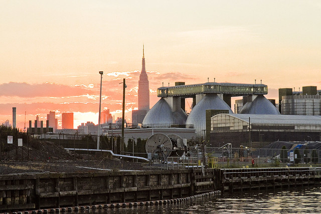
On the Brooklyn or Greenpoint side of Newtown Creek, the former home of the Standard Oil Company of New York and birthplace of what would be one day known as Mobil Oil is closest to the camera, which are now the ExxonMobil Greenpoint Remediation Project properties at 400 Kingsland Avenue.
Sitting on part of the former oil company properties in Greenpoint is the NYC DEP’s Newtown Creek Wastewater Treatment Plant, largest and newest of NYC’s 14 sewer plants.
– photo by Mitch Waxman
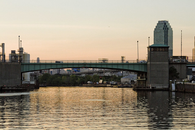
DUGABO – or Down Under the Greenpoint Avenue Bridge Onramp – is the heart of petroleum country on Newtown Creek. Greenpoint Avenue heads west into Brooklyn, terminating at the East River at Transmitter Park, whereas it continues into Queens and once having crossed Queens Blvd. – it transmogrifies into Roosevelt Avenue and continues all the way out into Flushing.
– photo by Mitch Waxman
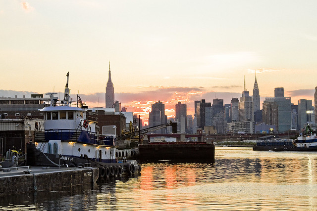
From a maritime industrial point of view, the DUGABO area surrounding the Greenpoint Avenue Bridge is probably one of the busiest sections of Newtown Creek in the 21st century. SimsMetal and Allocco Recycling host regular tug and barge traffic, as does Metro fuel.
In the distance is the Pualski Bridge and the towers of the Shining City of Manhattan.
Upcoming Events and Tours
Saturday, August 6th, 2:00 p.m. – 4:00 p.m. –
Insalubrious Valley Walking Tour,
with NY Adventure Club. Click here for more details.
Sunday, August 14th, 11:00 p.m. – 1:00 p.m. –
Calvary Cemetery Walking Tour,
with Atlas Obscura. Click here for more details.
Sunday, August 21, 11:00 a.m. – 1:00 p.m. –
Poison Cauldron Walking Tour,
with Atlas Obscura. Click here for more details.
“follow” me on Twitter- @newtownpentacle
tradition emphasizes
Creek week continues, in today’s post.

– photo by Mitch Waxman
As promised in yesterday’s post, a different perspective on the Creek is offered today. For the last few days, we’ve been on the DEP property in Greenpoint, and a birds eye perpective on DUGABO – Down Under the Greenpoint Avenue Bridge Onramp – was offered. In today’s post, the POV is from onboard a NY Water Taxi, and it’s the English Kills Tributary of the larger Newtown Creek.

– photo by Mitch Waxman
That’s the Metropolitan Avenue Bridge, as seen from the turning basin adjoining it, looking east towards Bushwick and East Williamsburg. I call this spot DUMABO – Down Under the Metropolitan Avenue Bridge Onramp. In colonial times, this was traditionally the demarcation point between fresh and brackish water on the Creek, but back then English Kills was fed by dozens of upland streams and springs. The water bubbling up out of the earth up on the hills of Ridgewood and Bushwick are part of what drew the Germans out here, and a lot of them – like the Ulmers – were involved in the beer business.
The beer guys, who do the holy work of delivering sacrament to bars and bodegas, are still in the area but there’s mainly micro brew hipster stuff going on these days and it’s fed by the DEP’s croton water system rather than ground water. The big guys like Budweiser – pictured above – ship their product in from elsewhere. There’s a pretty big beer distributor nearby on Grand Street, whose warehouse backs up on English Kills, and that Bud Light truck is likely heading there.

– photo by Mitch Waxman
Also on Brooklyn’s Grand Street is the former Charles J. King recycling company, which seems to have recently changed ownership. Luckily, the new owners continue to exploit their maritime bulkheads to ship their product out of the area, rather than truck it out. The sections of Brooklyn and Queens surrounding the eastern sector of the Newtown Creek have some of the highest concentrations of heavy truck traffic in the entire City of New York.

– photo by Mitch Waxman
That’s the NYC DOT’s Grand Street swing bridge in the shot above, a 1909 relic of the days when Tammany Hall came to Newtown Creek shortly after the consolidation of the City of Greater New York in 1898. It’s the titular ornamentation signifying the positioning of the currently undefended legal border of Brooklyn and Queens. On the Queens side of the bridge, Grand Street becomes Grand Avenue, which travels through Maspeth and several other communities. Despite a few interruptions in its path introduced by Robert Moses, Grand Avenue eventually enters Astoria and becomes 30th avenue which heads all the way down to the East River near Halletts Cove.
Of course – on the Brooklyn side – Grand Street more or less connects to the East River in Williamsburg.

– photo by Mitch Waxman
The Brooklyn side concrete company pictured above, called Empire Transit Mix, is sited on what was once called Furman Island. There used to be two islands found in the neighborhood of Maspeth Avenue, with the smaller one known as Mussel Island. Mussel was dredged away in the WW1 era, and its spoils were used to connect Furman Island to Brooklyn. This netted Brooklyn a bit of additional land mass and supposedly increased its legislative delegations by one seat.
Furman Island is the former home of Peter Cooper’s Glue Factory, Martin Kalbfleisch’s Acid and Chemical works, and Conrad Wissel’s Night Soil and Offal dock.

– photo by Mitch Waxman
The area where the Newtown Creek widens out is referred to as “the Turning Basin” and it’s where you’ll find the National Grid company’s LNG facility, which sits on a former Manufactured Gas Plant which was operated by the Brooklyn Union Gas Company. There’s a lake of coal tar under the National Grid property, and a wall of the stuff clinging to their property in the water.
As a note, I have made multiple attempts to formally visit the National Grid site, using institutional means. Polity and smarmy conviviality have been met with a brick wall of denial of entry. Every attempt to learn what goes on there has been met with obfuscation and a cry of “Homeland Security.” It’s a “no cameras” zone, National Grid says. It’s a “Marsec 1” zone, National Grid says.
It’s visible from above, via the Kosciuszcko Bridge, and from the water, and from the street sides – say I. I’ve got long zoom lenses, as well. I’ve also got access to documentation on the place via the environmental review process, State DEC oversight, and the Superfund investigations.
One wonders what they’re hiding back in there. I’ll find out over the course of time.

– photo by Mitch Waxman
Speaking of the Kosciuszcko Bridge, at the western end of the turning basin, you’ll find the 1939 span and the replacement span which the State DOT is currently working on.
These shots were captured just last week while onboard a pair of sold out Open House NY tours of the Newtown Creek which I conducted with my colleague T. Willis Elkins from Newtown Creek Alliance. My practice on these tours is to narrate the excursion – discussing the past – in from the East River to the Metropolitan Avenue Bridge, then hand the microphone over to Willis – who discusses the future.
While he’s talking, one grabs the camera and gets busy.
Upcoming Events and Tours
Sunday, August 14th, 11:00 p.m. – 1:00 p.m. –
Calvary Cemetery Walking Tour,
with Atlas Obscura. Click here for more details.
Sunday, August 21, 11:00 a.m. – 1:00 p.m. –
Poison Cauldron Walking Tour,
with Atlas Obscura. Click here for more details.
“follow” me on Twitter- @newtownpentacle
prodigious grasp
From high atop Greenpoint.

– photo by Mitch Waxman
The eight anaerobic digester eggs of the Newtown Creek Wastewater Treatment plant in Greenpoint gather a lot of attention. At the very top of these stainless steel vessels are catwalks which connect them together into two groups of four. You’re something like 140 feet up, and the entire assembly is wrapped in blue green glass.
The shot above looks southwest, across Brooklyn.

– photo by Mitch Waxman
On top of each of the individual eggs, you’ll find all sorts of plumbing and control mechanisms. There’s also a view port through which you can observe the bubbling sludge as its “cooked” by the biological processes within.

– photo by Mitch Waxman
Just for perspective, here’s a look at the things from outside the plant. The shots in today’s post were captured from the catwalk closest to the camera.

– photo by Mitch Waxman
It’s actually fairly challenging to shoot from the catwalks, as that green glass screws around with the camera’s light meter and sensors. There’s also reflections to deal with, which you’ll see a few of in these shots, and needless to say – the glass ain’t exactly super clean.

– photo by Mitch Waxman
Looking down at Kingsland Avenue and Allocco Recyling, over the methane jets which burn off the mephitic gas produced by the digester eggs.

– photo by Mitch Waxman
Looking towards the Greenpoint Avenue Bridge, towards Blissville in Queens.

– photo by Mitch Waxman
Looking west, over the Newtown Creek Wastewater Treatment Plant’s grounds, towards Manhattan.

– photo by Mitch Waxman
Another perspective on the Greenpoint Avenue Bridge, this time with Blissville’s former Van Iderstine property, Calvary Cemetery, and the Kosciuszcko Bridge at the Maspeth border in frame.

– photo by Mitch Waxman
The Kosciuszcko Bridge replacement project is in the background, with a “green asphalt” plant and a Waste Management transfer station in the fore. That’s Newtown Creek flowing on the right side of the shot.

– photo by Mitch Waxman
A wider view of the scene, this time you’ve got the ExxonMobil 400 Kingsland Avenue property in view as well.

– photo by Mitch Waxman
Tomorrow – Creek Week continues, but from an entirely different perspective.
Upcoming Events and Tours
Wednesday, August 3rd, 6:30 p.m. – 8:30 p.m. –
Glittering Realms Walking Tour,
with NYC H2O. Click here for more details.
Saturday, August 6th, 2:00 p.m. – 4:00 p.m. –
Insalubrious Valley Walking Tour,
with NY Adventure Club. Click here for more details.
Sunday, August 14th, 11:00 p.m. – 1:00 p.m. –
Calvary Cemetery Walking Tour,
with Atlas Obscura. Click here for more details.
Sunday, August 21, 11:00 a.m. – 1:00 p.m. –
Poison Cauldron Walking Tour,
with Atlas Obscura. Click here for more details.
“follow” me on Twitter- @newtownpentacle
sprightly cleric
Up Dutch Kills, with a paddle.

– photo by Mitch Waxman
My pal T. Willis Elkins, who’s the Project Manager of Newtown Creek Alliance and the co chair of the Newtown Creek CAG, sent out an invite recently inquiring whether I might have any interest in taking an evening paddle with employees of the NYC DEP on my beloved Newtown Creek – specifically up the Dutch Kills tributary in LIC and a couple of other points of nearby interest in Booklyn.
How could I resist?
T. Willis is also one of the show runners at North Brooklyn Boat Club, found in Greenpoint under the Pulaski Bridge, so that’s where our little crew met up. We donned life vests, listened to Will’s safety speech, and got into canoes. I chose to go out in the smaller of the two boats, presuming that it would be a better spot to take pictures from than the enormous version that everybody else would be in.
The only condition which T. Willis set down for the trip was that everybody would have to row, but… cardio, right?

– photo by Mitch Waxman
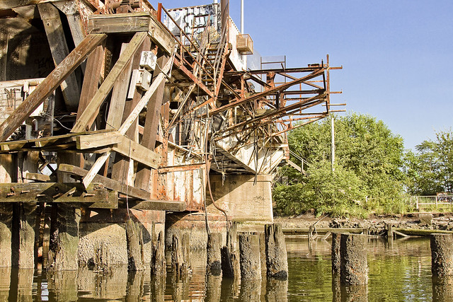
T. Willis had timed our trip to coincide with low tide on the Creek, which is required to pass beneath the MTA’s non functional Cabin M railroad swing bridge which is – at best – just a few feet over the water. We headed into Long Island City along the Dutch Kills tributary of Newtown Creek, and pictured above is the second of the bridges you’ll find along the tributary – Cabin M – which is a truss bridge that can actually open and close.
– photo by Mitch Waxman
The shot above looks east along Cabin M towards the SimsMetal dock. DB Cabin services the Lower Montauk branch of the LIRR’s freight operations, connecting the Wheelspur and Blissville yards. The Long Island Railroad tracks follow the main stem of the waterway eastwards into Blissville, Maspeth and eventually turn north towards Fresh Pond. This traffic is maintained and operated by LIRR’s contracted freight partner, the NY & Atlantic.
Cabin M is part of the now defunct Montauk Cutoff tracks, which provided access to the Sunnyside Yards from the freight tracks along the Creek. The Montauk Cutoff itself was detailed in this post last year.

– photo by Mitch Waxman
We proceeded along Dutch Kills and passed under the venerable Borden Avenue Bridge, one of only two retractile bridges in the City of Greater New York. The sections of Borden Avenue it connects were swamp land until the Army Corps of Engineers blew through in the decade following the Civil War, creating first a “plank road” through the already despoiled wetlands, then a few decades later laying macadam roads and filling in the swamps with landfill. It wasn’t until 1909 that this area kicked into high gear, after the Queensboro Bridge opened. With the construction and creation of the nearby Sunnyside Yards, and the Degnon Terminal industrial zone which surrounds Dutch Kills, this section of LIC soon became known as “America’s Workshop.”

– photo by Mitch Waxman
The head of Dutch Kills sports a “turning basin” built for shipping, which isn’t used in modernity due to that non functioning rail bridge – DB Cabin – found at its intersection with the main stem of Newtown Creek. The turning basin is nearly a mile back into Long Island City, and you can really get a sense of how much new construction is happening in LIC from back here.
There’s also a couple of pretty large combined sewer outfalls – CSO’s – back here, which everybody’s friends at the DEP whom we were paddling with are actually responsible for. The pipes here are connected to the Bowery Bay Sewage Treatment plant in Astoria, for the vulgarly curious.

– photo by Mitch Waxman
I’ve shown you before – lords and ladies – the abandoned fuel barges found back here, which have been allowed to rot away into the water – in previous posts. I’ve also described to you the “situation” which the American Warehouse company has found themselves in during the early 21st century – wherein the undermining of their site by the waters of Dutch Kills have cost them a pretty penny to shore up. Many, many million pennies, I’m told.

– photo by Mitch Waxman
On our way out, we passed under the Hunters Point Avenue Bridge. All of the NYC DOT administered bridges on the Newtown Creek and its tributaries are maintained in working order, and I’ve witnessed this single bascule drawbridge being opened and closed.
Heck, I was a parade Marshall for its centennial, and we even had a parade.

– photo by Mitch Waxman
Our little group visited a couple of other spots nearby, Unnamed Canal and Whale Creek, then rowed out to the Creek’s intersection with the East River for a bit. Along the way, I spotted this feral fellow in Greenpoint.
Upcoming Events and Tours
Wednesday, August 3rd, 6:30 p.m. – 8:30 p.m. –
Glittering Realms Walking Tour,
with NYC H2O. Click here for more details.
Saturday, August 6th, 2:00 p.m. – 4:00 p.m. –
Insalubrious Valley Walking Tour,
with NY Adventure Club. Click here for more details.
Sunday, August 21, 11:00 a.m. – 1:00 p.m. –
Poison Cauldron Walking Tour,
with Atlas Obscura. Click here for more details.
“follow” me on Twitter- @newtownpentacle
following day
puzzling things, general weirdness, and an update on that transformer fire in Astoria.

– photo by Mitch Waxman
Out on the water in NY Harbor recently, the scene above was observed.
Famously, one of those “harbor advocacy” statements which one is oft heard announcing on my walking and boat tours is that “maritime is the greenest way to transport cargo, with a single barge carrying the equivalent of thirty eight trucks worth of stuff,” but you seldom see it literally expressed by a barge carrying an actual truck. My rhetorical statement is actually built around a full sized flat top barge carrying cargo containers and guided by harbor sized tugboat type of scenario, rather than a smallish work barge that’s carrying a dump truck and being towed by a little push boat.
The push boat is the TJ Miller, btw, which operates of Staten Island’s Millers Landing.

– photo by Mitch Waxman
Passing by the Fuller Brush, or Flatiron building if you must, recently – I couldn’t get the whole 23 Skidoo stuff to exit my brain. I went to college a few blocks away at the School of Visual Arts, and Manhattan’s 23rd street was – and remains – one of the main thoroughfares of my life. Post college, most of the advertising agencies which I worked for were located somewhere within a few blocks of the Flatiron for some reason. I seldom photograph along its route, however, as the School of Visual Arts is – as mentioned – just down the block. They have a world class photography program there, and the 23rd street corridor is probably one of the most “captured” spots on the planet. While I was at SVA, I was in the illustration program, so unfortunately I haven’t got much in the way of documentation of the 1980’s version of it as I was drawing comics and painting and stuff back then.
It makes me wonder, however. Taking the Flatiron as an example, which is one of the most photographed buildings in NYC, and has been for a century… one ponders what information about our environment could be gleaned from assembling the decades long recordings of its appearance. Weather patterns, erosion, particulate levels in the air?

– photo by Mitch Waxman
Back in Astoria, after that transformer explosion I described to you a couple of weeks ago, it took the Con Ed guys about three days – working 24 hours, mind you – to put things back in order. There’s still crews working around two to three blocks north and to south, as presumptively wherever the wires connected to that failed equipment led to must have been also been damaged or affected by the event. That’s my guess anyway.

– photo by Mitch Waxman
It took the Con Ed crews just under a day to get the blacked out block of 44th street between 34 avenue and Broadway back on the grid, but that’s when their real job began. I don’t know too much about their operation, but I can describe how it played out. First there were emergency crews who arrived in red trucks who “put out the fire.” They were followed by a far larger contingent of blue truck crews who arrived with a variety of equipment and what seemed like a third party contractor. As the project went on, the cable trucks arrived, one of which is in the shots above.

– photo by Mitch Waxman
The (seemingly) third party contractor got busy digging up a pretty sizable trench leading from the transformer and following the curbline. The blue truck guys were moving in and out the manholes and had a substantial amount of equipment deployed. They were all working during the sweltering July heat, incidentally.
About three days after the transformer fire, they all suddenly left.

– photo by Mitch Waxman
Just another blackout in Astoria, Queens, I guess.
Upcoming Events and Tours
Tuesday, July 26, 6:30 p.m. – 8:30 p.m. –
Glittering Realms Walking tour,
with NYC H2O. Click here for more details.
Wednesday, July 27, 1st trip – 4:50 p.m. 2nd trip – 6:50 p.m. –
2 Newtown Creek Boat Tours,
with Open House NY. Click here for more details.
Saturday, July 30, 11:00 a.m. – 1:00 p.m. –
DUPBO Walking Tour,
with Atlas Obscura. Click here for more details.
Sunday, August 21, 11:00 a.m. – 1:00 p.m. –
Poison Cauldron Walking Tour,
with Atlas Obscura. Click here for more details.
“follow” me on Twitter- @newtownpentacle


