Posts Tagged ‘Ridgewood’
local impressions
East Branch, Newtown Creek.
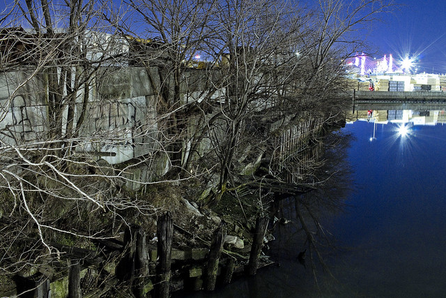
– photo by Mitch Waxman
Geography indicates that I don’t hit the eastern sections of Newtown Creek as regularly as I do the western side. It’s quite a walk from Astoria to Ridgewood, after all. The East Branch is absolutely disgusting all the time, due to the presence of a gigantic seven vaulted sewer which drains parts of Brooklyn as far away as Canarsie. There is virtually zero laminar “flow” back here due to tidal influence, and the water instead exists in a vertical column with the poison sediment suspended in gradient horror.
God, how I love it all. The smell… it’s like rotting ham floating in watery mayonnaise.
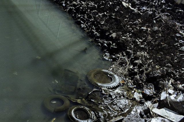
– photo by Mitch Waxman
One is constantly amazed at the willful littering encountered all over Queens. People standing next to a corner trash can will opt to toss garbage in the street rather than using the bin. Got a tire or two you’re done with? Why dispose of it properly when you can just haul it up to chest level and then throw it over a fence into an area waterway?
Don’t take my chides the wrong way, I’m no saint, but doesn’t it take more effort to get rid of your tire this way than it does to just leave it in the corner by the DSNY bin? Both are illegal, of course, but seriously… it takes a lot more effort to toss the thing in the water than it would to roll it to a corner.

– photo by Mitch Waxman
That structure on the right hand side of the shot is the MTA’s counting house, a fortress like building where they process all the cash from bus boxes, metro card machines, and subway fare control booths. All those armored cars and armed guards you see in the subway? Yup, this is one of the places they report to work.
I’ve actually met people who work here. They described what life is like inside. It seems that to ensure nobody pockets any of MTA’s cash, a pocketless jumpsuit with a padlock on the zipper is worn by the workers. If you need to use the bathroom, your supervisor has to unlock your coverall and you are searched before and after using the facility. My reaction to this was to ask if it was anything like the drug operation in the movie “New Jack City” in there.
The answer was “yes.”
“follow” me on Twitter- @newtownpentacle
Buy a book!
“In the Shadows at Newtown Creek,” an 88 page softcover 8.5×11 magazine format photo book by Mitch Waxman, is now on sale at blurb.com for $30.
hellish import
Ridgewood, Queens.

– photo by Mitch Waxman
A humble narrator is taking a short break this week, and you’ll be greeted with single shots when visiting this – your Newtown Pentacle. Trust that I’m out and about gathering new tales to tell and photographs to display.
Upcoming Tours and Events
June 9th – Exploring Long Island City – with NY Adventure Club.
Long Island City is a tale of two cities; one filled with glittering water-front skyscrapers and manicured parks, and the other, a highly active ground transportation & distribution zone vital to the New York economy — which will prevail?
Tickets and more details here.
“follow” me on Twitter- @newtownpentacle
veritable ossuary
It’s National Pie Day, thanks to the American Pie Council, in these United States.

– photo by Mitch Waxman
People think I’m exaggerating, all the time, about the poison earth surrounding my beloved Creek.
They say it can’t possibly be as horrible as I say it is along the Newtown Creek. Thing is, they’ve never been here during the workday, but instead visited on some nice Saturday in July. To understand the horror of it all, you need to see it, smell it, experience it – personally. That’s why I do my walking tours, but the walking routes I take the public out on are as safe a set of paths as you can possibly scout through the Newtown Creek Industrial Districts. As a note – whenever I’ve got a regulator or political official out with me, I take them to places which are best described as “hell.” I figure that since these officials, and their forebears, are pretty much responsible for letting all of this happen in the first place that they should experience it in toto.
Before I continue… should you decide to come and explore these areas for yourself, I accept zero responsibility or liability for you doing so. I’m telling you point blank, stay away from the borderland of industrial Bushwick and Ridgewood, and the corner of Scott and Randolph in particular. You can easily get hurt, or worse. It’s Mordor up in here, with giant trucks whizzing around, which scare away rodents of unusual size – critters who are oddly used to being out in the daylight. There’s a whole set of rules around here that you aren’t necessarily privy to either. It’s too late for me, but save yourself.
Stay away from the Scott Avenue footbridge zone, yo, this shit’s nasty.

– photo by Mitch Waxman
That’s the Scott Avenue Footbridge pictured above, incidentally, which provides one with an interesting vantage point to observe the area from. It’s a bit like a hunting stand providing an elevated POV in the middle of some savanna. The bridge itself is typical of the Long Island Railroad footbridge model you’ll find all over Queens. A steel and concrete structure that provides pedestrian egress high over one of their train lines. In the case of this particular bridge, which is quite dilapidated I would add, the train tracks it overflies are the Bushwick Branch of the LIRR.

– photo by Mitch Waxman
Almost every other time that I’ve stood on this footbridge during the last decade, the New York and Atlantic freight operation has had literally hundreds of rail cars lined up along it – which compose the so called “Garbage Train.” Like all of the sections of North Brooklyn which touch the Newtown Creek, gentrification is under way in Bushwick. Large numbers of people are moving in just a few blocks east of here. Flushing Avenue’s intersection with St. Nichols is just a few blocks east of here – the heart of the “Brooklyn thing” which the real estate guys are so into.
Notably, the real estate guys will sometimes refer to this area as Williamsburg, rather than Bushwick or East Williamsburgh, to prospective clients. Eventually, “Williamsburg” will extend into Nassau County.

– photo by Mitch Waxman
This little neighborhood of blue collar laborers, however, is rife with hazard for the unwary. As has often been mentioned, the “working guys” have a protocol for handling themselves around heavy equipment and such, and not being privy to its mores makes you quite vulnerable to random accident. For instance – never, NEVER, cross in front of a piece of equipment – whether it truck, forklift, whatever – without stopping and waiting for the operator to acknowledge you and wave you on. Can’t tell you how many people I see just darting in front of construction equipment.
Also, advice offered to everybody crossing Northern Blvd. back in Queens is to stand behind a pole or something while you’re waiting for the light to change. Same thing applies in Queens Plaza, and the western extent of Queens Blvd. which feeds into it.

– photo by Mitch Waxman
There’s a waste transfer station, or twenty, hereabouts. The garbage guys will tell you “it’s got to go somewhere,” and in the case of the Newtown Creek watershed and surrounding industrial districts, about a third of New York City’s garbage comes here every day. Trucks come in full and leave empty, leaving behind tons and tons of construction debris, recyclables, and putrescent waste.
Have I ever mentioned that I don’t seem to get sick that much, almost as if my immune system is all jacked up and running at maximum speed for some reason?

– photo by Mitch Waxman
Looking north-west (ish) you’ll notice the everpresent Sapphire Megalith of Long Island City.
One navigates about the Newtown Creek via triangulation of position between the Freedom Tower in lower Manhattan, the Empire State Building in midtown Manhattan, and the Sapphire Megalith in LIC.
To wit – if you want to go the waterfront of the East River in LIC from Ridgewood or Maspeth, find a spot where the Empire State and the Megalith seem to line up and head in that direction. Going to Astoria? Keep the Megalith and Empire State on the left. Williamsburg? Freedom Tower at center with Empire State on your right and the Megalith behind you. When they finish all that horrible construction in LIC, I’ll have to decide on a new landmark, as the megalith won’t be the tallest building in Queens much longer.

– photo by Mitch Waxman
Close to the corner of Metropolitan Avenue and Scott is a NYC Department of Public Works access – or manhole – cover embedded in the sidewalk. DPW is one of the many agencies that were compressed into the DEP back in 1983, and out here in North Brooklyn, DPW was the inheritor of the City of Brooklyn’s 19th century sewerage projects which were all consolidated into the City of Greater New York’s holdings in 1898. It’s an intersecting sewer, which my “understanding of” indicates that below will be found some vault like structure that leads into a big pipe on one side, which is fed by a series of smaller pipes located on the other – but I don’t know that because I haven’t been down there.
The smaller pipes do feed in from upland sources, and in the case of this spot, those sources can be as far away as East New York and Canarsie. That’s something I actually do know since I’ve argued about it with officialdom.
The big pipe empties into the East Branch of the Newtown Creek across the street, at a “the size of a semi truck trailer” open sewer that’s called “Combined Sewer Outfall NC-083.” This CSO pollutes the water here with some 586 million gallons of untreated sewage a year, which is a debatable and out of date number that’s attibutable to official sources. It’s amongst the largest of the 400 CSO’s in the City, just as a note. A major contributor, roughly 20%, to the approximately billion and half gallons of raw sewage that flows into Newtown Creek annually, can be accessed below this hatch.

– photo by Mitch Waxman
BPF? A water main cover which is close proximity to the “intersecting sewer” hatch featured above, the “BPF Water” thing torments one such as myself. Does “BP” stand for “Borough President,” and if so, “Borough President” what? Is it “Brooklyn” or something else?
Arghhhhh. Something which I don’t know every detail of around the Creek? I’m a complete failure, and now everybody knows it.
Sometimes, if I didn’t make this “job” of mine up out of thin air, I’d complain about how little I get paid for the sheer angst of not knowing what the legend on some random water main cover means.

– photo by Mitch Waxman
Tittering laughter was heard, carried by an easterly breeeze, as one approached Metropolitan Avenue.
My theory is that some inhuman thing with a three lobed burning eye – housed in the cupola of a sapphire megalith found miles away – made this sound as it giggled at the frustrations of a humble narrator.
Back tomorrow, with something completely different at this – your Newtown Pentacle.
“follow” me on Twitter- @newtownpentacle
distant valley
Ridgewood has its charms, lord and ladies.

– photo by Mitch Waxman
I love the esthetics of the section of Ridgewood nearby Fresh Pond Road, which offers block after block of pretty as you please row houses – many of which utilize Kreischer bricks in their street facing facades. I don’t know this neighborhood as well as I’d like to, as it’s quite a hike to walk here from Astoria. Last week, occasion carried me to Ridgewood, where this view was gathered. One plans on spending a bit more time in this section in the coming months, although I’m still a bit uncomfortable in residential areas – preferring the concrete devastations and lonely industrial zones surrounding my beloved Creek.

– photo by Mitch Waxman
This kids ride was sitting outside a deli, and it caught my eye. Haven’t seen this goofy Pelican sculpture before, normally you get horses and race cars on these things. One of my local bodega owners on Broadway in Astoria (he’s got one that sports a pink elephant) told me that he splits the earnings with the company that owns the unit 50/50, and that he can expect more than $300 a week from the thing. That’s a lot of quarters.

– photo by Mitch Waxman
Street furniture like these kid rides are the sorts of things that the big league historians typically overlook, as the “college boys” prefer to focus in on structures, infrastructure, and demographic patterns. They tend to miss the little stuff in favor of broad swath trends, in my opinion. When, exactly did “penny candy” become surprisingly expensive? When did the Bearclaw disappear from NYC? That’s where I come in. Now, you got a quarter? I want to ride the pelican.
“follow” me on Twitter- @newtownpentacle
immemorial past

– photo by Mitch Waxman
Not unlike the woodland elves described in Tolkien stories, the Dutch had been diminishing for some time in their former free holds, and by the middle of the 19th century they had largely departed for that place where the burning thermonuclear eye of god goes at the end of the day. Their old haunts had grown lousy with the English, Germans, and Irish by this point in time anyway and they must have realized that their time had come to an end on Long Island’s western tip. Sightings of them continued right up to the beginning of the 20th century, but these days the Dutch in Ridgewood are functionally extinct. There may still be one or two, but these are anachronistic individuals.
from onderdonkhouse.org
The Vander Ende-Onderdonk House, located in Ridgewood on the border of Queens and Brooklyn, is the oldest Dutch Colonial stone house in New York City. Peter Stuyvesant granted the land it sits on in the mid-seventeenth century, and by 1660, Hendrick Barents Smidt occupied a small house on the site. In 1709, Paulus Vander Ende of Flatbush purchased the farm and began construction of the current house. The building was a prominent marker in the 1769 settlement of the boundary dispute between Bushwick in Kings County and Newtown in Queens County.

– photo by Mitch Waxman
Reports from the time describe an odd and curiously industrious people, possessed of peculiar notions considered alien and sinister by the English (and eventually American) gentry who replaced them. These Dutchmen allowed property to fall into the hands of female heirs, considered their slaves to be indentured servants rather than livestock, and even tolerated congregations of Jews and Catholics gathering for their sabbaths (provided that they show discretion and deference, of course). Savages, atavist savages, they were.
from 1910’s “Genealogy of the Onderdonk Family in America By Elmer Onderdonk“, courtesy google books
“On Saturday, Sept. 21, 1776, the day after the great fire in N. Y., a detachment of Col. Birch’s 17th Light Dragoons visited Great Neck, Cow Neck, and in the afternoon they reached the house of Adrian Onderdonk, which they instantly surrounded, when an officer went in and searched every part up and down stairs, thrusting his sword into every secret place. The object of their pursuit happened to be at home, and on being arrested, he asked the reason of it, and in reply was informed “that your neighbors complain of you.” The officer then mounted his horse and rode off with the troopers, perhaps in quest of other Whigs on Cow Neck.
Adrian Onderdonk was taken as far as Flushing and shut up in the Friends Meeting House that night. The next day he was taken to New York, and on his arrival at the city he with other prisoners were paraded, with a gang of loose women marching before them to add insult to suffering.

– photo by Mitch Waxman
When they went into the west, these Knickerbockers failed to leave behind much other than a few place names and old houses, and the English speaking world was never apt to do much more than mention them in passing. Certainly, there were some Dutchmen who remained in their anglicized home, and their names are writ large across the historical record. Roosevelt, Van Cortlandt, Vanderbilt- all conjure some immediate memory or reactive instinct in modern audiences- but all in connection with Manhattan or “New York” rather than Long Island.
from 1911’s “American Prisoners of the Revolution, by Danske Dandridge“, courtesy google books
After nearly four weeks imprisonment the friends of Adrian Onderdonk procured his release. He was brought home in a wagon in the night, so pale, thin, and feeble from bodily suffering that his family scarcely recognized him. His constitution was shattered and he never recovered his former strength.
Onderdonk says that women often brought food for the prisoners in little baskets, which, after examination, were handed in. Now and then the guard might intercept what was sent, or Cunningham, if the humor took him, as he passed through the hall, might kick over vessels of soup, placed there by the charitable for the poor and friendless prisoners.

– photo by Mitch Waxman
Authors and orators created a narrative in the early middle 19th century about these original european colonizers of the New York archipelago, a whimsical and semi ironic one, and they came to be regarded as a primitive group of peasant “hay seeds”. Washington Irving and others wove together an image of a good natured yet quite illiterate and impressionable race of farmers and merchants often at the mercy of superstition and fate. Not much mention of religious remonstrances or the complicated political deals entered into with powerful aborigine nation states (which surrounded and vastly outnumbered them) is commonly spoken of, but lurks just below the surface of the English speaking origin mythology of the United States.
from bklyn-genealogy-info.com, where they have historic photos of the place!!!
It is called the ONDERDONK House because on April 27, 1821, Adrian ONDERDONK purchased the 58-acre farm with the house and barn for $6,000. The farm extended south from Flushing Avenue to what is now Catalpa Avenue. During the 1820’s, Adrian ONDERDONK erected a small frame addition to the stone house immediately above the remnants of the foundation of the 1660 building. Its architectural features are typical of Dutch buildings in this period: a gambrel roof, Dutch doors, central hallway and double hung windows with shutters.
Immediately west of the ONDERDONK Farm was the COVERT Farm of 48 acres. It is thought the original Dutch grant covered what was in the early 1800s the ONDERDONK and COVERT farms.
In 1819, Adrian ONDERDONK, married Anna WYCKOFF, daughter of Peter WYCKOFF, who had a large farm nearby on Flushing Avenue.
In 1865, Gertrude ONDERDONK SCHOONMAKER, daughter of Adrian ONDERDONK, was the owner of the farms. She sold off 30 acres, but continued to live on the farm.
In the 1890s, she sub-divided the balances of the farm and sold building lots.

– photo by Mitch Waxman
Progressive revisionism, a style of historical interpretation which reinforces a certain political philosophy popular in the United States during the middle and late 20th century, embraces a version of the “noble savage” concept. This is an old trope in European thought, which presupposes that the so called American Indians were possessed of neither property nor base motives prior to the arrival of the Europeans, and lived in some sort of vast peaceful commune with each other that celebrated naught but the world of nature. The “noble savage” population of North and South America concept originates centuries ago with Columbus, and has caused a terrific amount of carnage and suffering since.
from wikipedia
Originally, Ridgewood was part of the Dutch settlement Boswijk (Bushwick) and was later incorporated into the village of Breuckelen (Brooklyn). A legacy of this past stands today; Onderdonk House, which was erected in 1709. The house is the oldest Dutch Colonial stone house in New York City. Also located at the Onderdonk House site is Arbitration Rock, which was a marker for the disputed boundary between Bushwick and Newtown and essentially Brooklyn and Queens.

– photo by Mitch Waxman
The actual history of the aboriginal occupants of North America, in the time before the plagues of Europe were unleashed upon them, is less than bucolic according to a fragmentary and badly documented historical recod. To the north were found Seneca and Mohicans, to the east were the Rockaway, south and west were found the Lenape. These were just the big guys- the regional players- and a complicated web of suzerainty and an homage based economy sustained and involved thousands of smaller groups in a web of trade and diplomatic relations. The first attempt at establishing a colony in Maspeth failed precisely because the Dutch had underestimated the strength, sophistication, and reach of one of these tribal groups- and the States General and Dutch East India Company decided that it would just be easier to buy the land from the Indians than fight them for it. The Indians, by all reports, could not believe that these odd trouser wearing people from overseas wanted to actually live year round in a swamp. NY State, incidentally, has preserved several of the property contracts entered into by the Dutch with the natives.
from wikipedia
The Arbitration Rock was set in 1769 as the boundary marker between the two Long Island townships of Newtown and Bushwick. Since Newtown was in Queens County and Bushwick in Kings County, this rock the size of a Volkswagen Beetle also served to mark the dividing line between these two colonial New York counties.
An acrimonious dispute over the boundary lines between the two townships had started as far back as 1661. “The feeling ran so high than men of one community would stone those of another.” To a large extent, the dispute reflected the conflict between the original Dutch settlers of Bushwick with the burgeoning English colonists of Newtown, New York.
In 1768, “a bill was passed in the legislature for a commission to draw a line to designate the boundary between the two townships.” In 1769, the borderline between the two towns and counties was established measured from this large rock that would ultimately be referred to as the “Arbitration Rock”. Still the dispute was not settled until 1880, when the state sent surveyors to verify the point on the old rock made in 1661.

– photo by Mitch Waxman
As mentioned, earlier this week, your humble narrator had found himself drawn to the Onderdonk site on Flushing Avenue in Ridgewood in the name of attending a meeting of the Newtown Creek Alliance. In a somewhat metaphoric setting – beneath a big tent- the group discussed current projects and certain plans for the near future. The Ridgewood Historic Society Group acted as our hosts, and this- like the disappearance of both the Indians and the Dutch from western Long Island- requires comment. Thanks are offered to them for their hospitality.
from nyc-arts.org
On display inside the house are objects found during excavations conducted in the 1970s and 1980s as well as architectural and historical exhibits. The house was built by Paulus Vander Ende, a Dutch farmer, about 1709. The smaller wooden wing was erected much later. In the early 1800s, the house was purchased by the Onderdonk family. After the last Onderdonk moved out, successive owners used the house as a livery stable, speakeasy, office and, most recently, as a factory for parts for the Apollo space program. The Greater Ridgewood Historical Society was formed to save the house, which was nearly destroyed by fire in 1975. It opened to the public in 1982.
Also- Upcoming Newtown Creek tours and events:

for an expanded description of the October 20th Newtown Creek tour, please click here
for more information on the October 27th Newtown Creek Boat Tour, click here

for more information on the November 9th Newtown Creek Magic Lantern Show, click here

for an expanded description of the November 11th Newtown Creek tour, please click here


