Posts Tagged ‘Tugboat’
lethal foliage

– photo by Mitch Waxman
Would that a humble narrator might tell you that these shots were captured whilst riding upon some Hedorah like cacodaemon, but it was actually during one of last fall’s Newtown Creek Tours and onboard an entirely mundane NY Water Taxi that the subject of this “Maritime Sunday” posting was photographed.
As you can see, something was advancing toward us on the Newtown Creek that day, something newly born.
from epa.gov
Newtown Creek, located in the City of New York, is a part of the New York – New Jersey Harbor Estuary and forms the northern border of the Borough of Brooklyn and the southern border of the borough of Queens. In the mid 1800s, the area adjacent to the 3.8 mile Newtown Creek was one of the busiest hubs of industrial activity in New York City. More than 50 refineries were located along its banks, including oil refineries, petrochemical plants, fertilizer and glue factories, sawmills, and lumber and coal yards. The creek was crowded with commercial vessels, including large boats bringing in raw materials and fuel and taking out oil, chemicals and metals.

– photo by Mitch Waxman
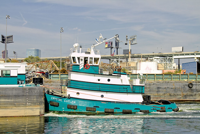
Built Nov. 04, 2010- this is the tugboat Crystal Cutler and her articulated barge (the Patricia E. Poling) plying the Newtown Creek. The article linked to below will tell you everything you could possibly ask about this tug and those who Captain and command her.
What mysteries they might have witnessed along the Creek, however, are not discussed in this profile.
The 70-foot, 1,500-hp twin-screw tug Crystal Cutler has been pushing and occasionally towing a 15,000-barrel clean oil barge since the tug was introduced in 2010. The tug places a high demand on her captains and crews as she ventures into shallow rivers and estuaries, moving about in a highly dynamic harbor with loads of gasoline, fuel additives or heating oil for small oil terminals.

– photo by Mitch Waxman
Amongst the larger harbor community, Newtown Creek is seldom referred to in glowing terms. There are those who dispute its role and historical significance to the maritime industry- as their eyes and hearts are drawn to the Brooklyn Navy Yard, the West Side of Manhattan, and the gargantuan modern ports in New Jersey.
Many would like to abandon it as an industrial corridor entirely, saying that its day as a working waterway is done, and give it over to kayaking and other recreational occupations.
Founded in 1995, Poling Cutler began operations near the time the former Poling Transportation went out of business.
The Founders of the new company were Ed Poling, whose grandfather started the former Poling company, and Gary Cutler who spent years working in the financial world before getting involved in Marine Transportation.
– photo by Mitch Waxman
One of the greatest sins along the Newtown Creek is precisely how few of its docks are utilized today. Most of the modern business along the Creek looks toward truck transportation to bring their goods to market and for the delivery of raw materials, ignoring their valuable docking rights and imprimature. Miles of bulkheads, expensively installed during prior generations, are allowed to rot away.
What a wasted opportunity.
Moving essential bulk materials by barge is more efficient economically and environmentally. From what we hear, a single barge has the same capacity as 28 – 56 long haul trucks, depending on the industry. Compared to other transportation modes, barge transport of bulk materials is safer in terms of worker injuries and generates far fewer emissions of particulate matter, hydrocarbons, carbon monoxide, CO2 and nitrous oxide on a per ton mile moved basis.
Despite the critical importance of barge transport as a best practice for industries on Newtown Creek, much of the bulkhead along this waterway is in disrepair. Overall bulkhead condition reveals a trend of disinvestment in maritime transit and a decline in related industries. According to Army Corps of Engineers, there were 19 businesses with working docks in 1999, compared to the nine that remain active today, as of January 2011.

– photo by Mitch Waxman
When you boil it down, the whole purpose of the Newtown Creek in its current form is to bring bulk goods into New York City by barge. Admittedly, the days of Standard Oil, Phelps Dodge, and the great Lumber interests are long gone- but… imagine some farmers in upstate New York loading their harvest goods onto a barge, and sending a floating green market directly to Long Island City or Greenpoint or even Maspeth. The barge could return to the farmer laden with cash and whatever else might be needed for the next harvest, completing a virtuous circle.
Imagine standing on the shoulders of giants, rather than rifling through their corpses like so many bugs.
from dot.ny.gov
Commercial and industrial development along Newtown Creek began circa 1854-60 and accelerated rapidly, spurred by low land values, water access for ships and boats, and relative remoteness from populated areas or regulations. The first kerosene refinery in the United States (1854) and modern oil refinery (1867) helped transform Newtown Creek into an industrial waterway. The first few industries also included a distillery near the Newtown side of the Penny Bridge, and the Peter Cooper glue factory relocated from elsewhere in Greenpoint to a site in Bushwick north of Maspeth Avenue10. The influx of industry and jobs, aggressive real estate development in and around Hunter’s Point, including LIRR’s presence on the creek in 1861, and the explosive growth of refined petroleum products all enhanced Newtown Creek’s attractions and helped transform the drainage into an industrial waterway circa 1860-1880. At the Industrial Revolution’s height, Newtown Creek’s industries were flourishing, bringing thousands of people to work at its plants and factories.

– photo by Mitch Waxman
The United States Coast Guard sometimes refers to Newtown Creek as part of “America’s Maritime Superhighway”, a vital industrial waterway which must be protected from the interests of those too short sighted to realize its potential to reinvigorate the economies of those communities through which it flows. It is the very definition of the future, and New York’s destiny is and has always been directly linked to it.
It’s heart warming to see clear eyed mariners like those onboard the Crystal Cutler plying its waters.
from nycppf.org
Significant Maritime and Industrial Area
Newtown Creek, at over 780 acres the city’s largest SMIA, abuts portions of the Greenpoint, Williamsburg, Long Island City, and Maspeth industrial areas. The waterfront area is characterized by heavy industry and municipal facilities, many of which are water- dependent. Newtown Creek is also the largest SMIA in terms of employment.
Although from 1992 to 2008 the SMIA lost roughly half its jobs, from 2000 to 2008 the number of jobs in the SMIA grew by nearly 1,400 to reach a total of approximately 15,000 jobs. Nearly half of the jobs in 2008 were in transportation and warehousing and wholesale trade. However, the business mix is becoming much more diverse. In the eight-year period examined, non-industrial jobs grew by more than 35 percent.
average specimens

– photo by Mitch Waxman
Captain Zeke is an 88 ton tug owned and operated by the White Near Coastal Towing Corp. of Syosset, and was built as the Lady Ora for Falgout Marine at Houma Shipbuilding in Louisiana back in 1980. Unfortunately, neither the company nor the tug have much information available about them, so there’s little more that can be said beyond its size- which is 30 m x 8 m, and its maximum recorded speed of 6.4 knots versus its average of 5.5 knots.
– photo by Mitch Waxman
Captain Zeke ran into a bit of trouble just a few years ago, on the Hudson River.
Spontaneous combustion involving paint rags in a fidley opening may have been the origin of the Aug. 31, 2008, fire aboard the Capt. Zeke, a Coast Guard investigator said. When their fire extinguishers proved inadequate, the tug crew fled to one of the barges.

– photo by Mitch Waxman
Speaking from a position of strictly deductive reasoning at this point, due to a lack of available information about this tug and its owners- Captain Zeke has been personally observed about the harbor moving small loads of a decidedly non volatile nature, as in the previous shot wherein the cargo seems to be sand.
It would be logical to assume that this role is well suited to the relatively small tug, which can most likely get into narrower spaces than the mated tug and barge gargantua which are employed by large players like Reinauer, Moran, or K-Sea (whose vessels specialize in the handling of volatiles) for the transport of various fuels and the handling of cargo vessels.
This theory is contradicted though, by this posting at the blog tuglife, which shows Captain Zeke tethered “on the hip” to a fuel barge.

– photo by Mitch Waxman
In the shots above and below, which were captured on the Kill Van Kull, Captain Zeke is tied to the sort of barge one regularly observes at Newtown Creek handling the SimsMetal trade in bulk metal. It is damnably odd, in the opinion of this humble narrator, that so little information is available online about this vessel. Normally, commercial maritime activity is copiously documented by a variety of private and government entities.
Regardless of this information vacuum, Newtown Pentacle’s “Maritime Sunday” nevertheless recognizes and sends a hearty greeting to Captain Zeke and its crew.
wild dances

– photo by Mitch Waxman
It’s Maritime Sunday again, here at your Newtown Pentacle, a weekly post which focuses in on and examines some aspect of NY Harbor- or the Sixth Borough as our friends from Tugster call it.
As many of you know, your humble narrator is quite the enthusiast for such matters, and serves as a Steering Committee member for the Working Harbor Committee. This role and set of interests often puts me in a position to witness and photograph interesting circumstance around the harbor, which these “Maritime Sunday” postings endeavor to share.
Today’s spotlight is cast upon the Moran Towing Tug “Kimberly Turecamo”.

– photo by Mitch Waxman
There are quite a few tugs with the surname Turecamo that are operated by Moran Towing, the result of a merger between two towing companies in the age of corporate expansion and conglomeration. The founder of Turecamo Coastal was born on an island in the Tyrrhenian Sea called Isola Lipari, part of the Aeolian Archipelago that straddles the distance between Mount Vesuvius and Mount Etna in fabled Italy. Lipari has a long and sordid history, a story which stretches back in time to the Estruscans, Greeks, and the Romans. The Island was once conquered by Arab Pirates, after all.
This of course, has nothing to do with the Tugboat Kimberly Turecamo, its just nice to know where certain folks hail from. The guy from Cake Boss on the TLC Channel, and Natalie Imbruglia- their dads come from Isola Lipari as well.
Turecamo Coastal and Harbor Towing Corporation was foundeded by Bartholdi Turecamo, who immigrated from Isola Lipari, a small island between the northern coast of Sicily and the southern tip of Italy. As an immigrant Turecamo found work in road construction around New York.

– photo by Mitch Waxman
Kimberly Turecamo, the tug, is from Louisiana. She also was one of the ships which assisted in the evacuation of lower Manhattan on September 11, 2001. One of the great stories from that day, it’s only the persistent modesty of those sailors who managed to move more than a quarter million people out of harms way that prevents this story from pervading the popular imagination.
Sailors are a different breed, and immodest only amongst themselves.
from morantug.com
It is reported that as many as 300,000 people were evacuated from lower Manhattan during an eight hour period following the attacks. When the evacuation first began, Moran had 11 tugs on the scene, each taking as many as 100 people to designated sites around the port, and to New Jersey. “After the initial surge of evacuation, we went down to about five boats on the scene, still working around the clock, and after four or five days we still had two boats working there at the end,” said Keyes. “As soon as the people were taken off, the boats were used for moving emergency crews, equipment and supplies.”
Moran tugs logged a total of 256 hours during the operation, according to Keyes. The tug Turecamo Boys was on the scene longest, with 84 hours logged, followed by Marie J. Turecamo with 51 hours and Margaret Moran with 49 hours. Other tugs involved with the evacuation were Nancy Moran, Brendan Turecamo, Kathleen Turecamo, Diana Moran, Kimberly Turecamo, Miriam Moran, Turecamo Girls and Catherine Turecamo.

– photo by Mitch Waxman
The iconic white “M” on their black stacks, coupled with the scarlet hull and white detailing, make Moran tugs the easiest craft to spot in NY Harbor. As mentioned in the past, there is just something iconic about them, and if you were to ask someone to describe a tugboat blindly- they would probably craft an image of something not unlike the Kimberly Turecamo.
Built in 1980, by McDermott Shipyard of Morgan City, Louisiana (hull #255) as the Rebecca P.
The tug was later acquired by Turecamo Maritime where she was renamed as the Kimberly Turecamo .
In 1998, Turecamo Maritime was acquired by the Moran Towing Corporation where the tug retained her name.

– photo by Mitch Waxman
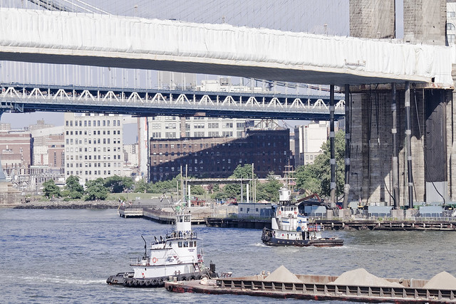
Kimberly Turecamo is at work in the shot above, guiding a fuel tanker through the narrow Kill Van Kull waterway. The Kill Van Kull at it’s narrowest point, between New Jersey and Staten Island, is a scant thousand feet wide and might boast a depth of merely 40-45 feet above the soft bottom. The cargo ships which come here in pursuit of trade are ocean going vessels whose titan engines would provide a lack of subtlety in handing such conditions.
The Kill Van Kull is a tidal straight, incidentally.
from morantug.com
Moran commenced operations in 1860 when founder Michael Moran opened a towing brokerage, Moran Towing and Transportation Company, in New York Harbor. The company was transformed from a brokerage into an owner-operator of tugboats in 1863, when it purchased a one-half interest in the tugboat Ida Miller for $2,700.
At the time, the Harbor was alive with ships – many of them still sail-powered – and Moran’s enterprise soon grew into a fleet of tugboats. It was Michael Moran himself who painted the first white “M” on a Moran tugboat stack, reportedly around 1880.

– photo by Mitch Waxman
An interesting bit of trivia about the harbor of New York is that its natural depth is a mere 17 feet, but was deepened by the actions of dredging to 24 feet before the end of the 19th century. The large ships of modernity utilize shipping channels which are deeper than the surrounding area, in particular the Ambrose Channel- a 1914 construct.
Ambrose leads the way in from a spectacular natural formation, a depression on the continental shelf called the New York Bight.
The Bight is clove by the terrifying depths of the Hudson Canyon.
from wikipedia
The western edge of Newark Bay was originally shallow tidal wetlands covering approximately 12 square miles (31 km2). In 1910s the City of Newark began excavating an angled shipping channel in the northeastern quadrant of the wetland which formed the basis of Port Newark. Work on the channel and terminal facilities on its north side accelerated during World War I, when the federal government took control of Port Newark. During the war there were close to 25,000 troops stationed at the Newark Bay Shipyard.
curious and cyclopean

– photo by Mitch Waxman
It’s Tugboat Sunday at the Newtown Pentacle, so let’s shine a little light on K-Sea’s Ross Sea. Named for the infamous Antarctic waters explored by Roald Amundsen, the ship is one of the newer tugs plying the waters of NY Harbor.
from k-sea.com
K-Sea Transportation Partners L.P., headquartered in East Brunswick, New Jersey, is a leading provider of marine transportation, distribution and logistics services in the U.S. From locations in New York, Philadelphia, Norfolk, Seattle and Honolulu, K-Sea operates a large fleet of tugs and tank barges that serves a wide range of customers, including major oil companies, oil traders and refiners.

– photo by Mitch Waxman
The Ross Sea, or specifically the Penguin infested Ross Island, is home to two volcanos which bear the dearest nomenclature of all geologic forms upon the earth- the polygenetic stratovolcano Mount Erebus, and the shield volcano Mount Terror.
The latter infernal mountain is mentioned in both the Poe Novella “The Narrative of Arthur Gordon Pym of Nantucket” and H.P. Lovecraft’s “At the Mountains of Madness” as well (although Lovecraft’s Mountains are in Western Antarctica, and assumed to be at least 1,000 KM from the Ross Sea).
for all the technical data, manufacturing history, and more photos of K-Sea’s Ross Sea- check out tugboatinformation.com

– photo by Mitch Waxman
The Ross Sea, as in the Antarctic, is named for explorer Sir James Clark Ross. An Englishman, Ross led an expedition to the frozen south in two wooden ships, HMS Erebus and HMS Terror- for which the volcanoes were named. The astounding Ross Ice Shelf is named for him, although he christened the formation as “The Victoria Barrier”.
It must be mentioned that Ross Sea, as in the Tugboat, was the winner of the 2011 Great North River Tugboat Race,
from workingharbor.com
The Great North River Race Results
- Ross Sea – Class A 1st place – Time: 4:44
- Quantico Creek – Class A 2nd Place – Time: 4:55
- Maurania III – Class A 3rd Place – Time: 4:55.5
- Catherine Miller – Class C 1st Place – Time: 5:54
- Pegasus – Class B 1st Place – Time: 5:56
- Susan Miller – Class C 2nd Place – Time: 6:09.
- Growler – Class C 3rd Place – Time: 6:13
- Freddie K. Miller – Class B 2nd Place – Time: 6:29
- Sea Wolf – Class B 3rd Place – Time: 6:48 Best Tatoo (Wayne)
- The Bronx – Did Not Race Little Toot Award & best mascot

– photo by Mitch Waxman
A question I’ve often heard asked often about Tugs with the sort of configuration that Ross Sea exhibits, a second wheel house atop the mast, is “why it is thus”?
Short answer is that it enables the pilot and or Captain the ability to see over a barge whose own height occludes the way forward.
from wikipedia
The Ross Sea was discovered by James Ross in 1841. In the west of the Ross Sea is Ross Island with the Mt. Erebus volcano, in the east Roosevelt Island. The southern part is covered by the Ross Ice Shelf. Roald Amundsen started his South Pole expedition in 1911 from the Bay of Whales, which was located at the shelf. In the west of the Ross sea, McMurdo Sound is a port which is usually free of ice during the summer. The southernmost part of the Ross Sea is Gould Coast, which is approximately two hundred miles from the Geographic South Pole.
All land masses in the Ross Sea are claimed by New Zealand to fall under the jurisdiction of the Ross Dependency, but few non-Commonwealth nations recognise this claim.
A 10 metre (32.8 feet) long colossal squid weighing 495 kilograms (1,091 lb) was captured in the Ross Sea on February 22, 2007.
unlighted river

– photo by Mitch Waxman
Another DonJon tug is in the spotlight today, this time it’s the Paul Andrew. It’s pictured above at Port Elizabeth Newark, moving a barge past one of the gargantuan cargo docks which distinguish the place.
from wikipedia
The Port of New York was really eleven ports in one. It boasted a developed shoreline of over 650 miles (1,050 km) comprising the waterfronts of Manhattan, Brooklyn, Queens, the Bronx, and Staten Island as well as the New Jersey shoreline from Perth Amboy to Elizabeth, Bayonne, Newark, Jersey City, Hoboken and Weehawken. The Port of New York included some 1,800 docks, piers, and wharves of every conceivable size, condition, and state of repair. Some 750 were classified as “active” and 200 were able to berth 425 ocean-going vessels simultaneously in addition to the 600 able to anchor in the harbor. These docks and piers gave access to 1,100 warehouses containing some 41,000,000 square feet (3,800,000 m2) of inclosed storage space.
The SS Normandie arriving in New York Harbor on maiden voyage escorted by several tugboats.
In addition, the Port of New York had thirty-nine active shipyards, not including the huge New York Naval Shipyard on the Brooklyn side of the East River. These facilities included nine big ship repair yards, thirty-six large dry-docks, twenty-five small shipyards, thirty-three locomotive and gantry cranes of fifty ton lift capacity or greater, five floating derricks, and more than one hundred tractor cranes. Over 575 tugboats worked the Port of New York.

– photo by Mitch Waxman
These shots were acquired while onboard one of the many Working Harbor Committee tours of industrial Newark Bay and environs in September of 2011, which explains the glorious lighting.
Autumn is one of the times of the year in New York City during which the angle of the sun creates a golden orange “theatrical lighting” effect.
from wikipedia
The port consists of a complex of approximately 240 miles (386 km) of shipping channels as well as anchorages and port facilities. Most vessels require pilotage and larger vessels require tugboat assistance for the sharper channel turns. The natural depth of the harbor is about 17 feet (5 m), but it had been deepened over the years, to about 24 feet (7 m) controlling depth in 1880.[12] By 1891 the Main Ship Channel was minimally 30 feet (9 m). In 1914 Ambrose Channel became the main entrance to the Harbor, at 40 feet (12 m) deep and 2,000 feet (600 m) wide. During World War II the main channel was dredged to 45 feet (14 m) depth to accommodate larger ships up to Panamax size. Currently the Corps of Engineers is contracting out deepening to 50 feet (15 m), to accommodate Post-Panamax container vessels, which can pass through the Suez Canal. This has been a source of environmental concern along channels connecting the container facilities in Port Newark to the Atlantic. PCBs and other pollutants lay in a blanket just underneath the soil. In June 2009 it was announced that 200,000 cubic yards of dredged PCBs would be “cleaned” and stored en masse at the site of the former Yankee Stadium, as well as at the Brooklyn Bridge Park. In many areas the sandy bottom has been excavated down to rock and now requires blasting. Dredging equipment then picks up the rock and disposes of it. At one point in 2005 there were 70 pieces of dredging equipment working to deepen channels, the largest fleet of dredging equipment anywhere in the world.

– photo by Mitch Waxman
Writing this in the depth of frozen January, your humble narrator literally aches for the shirt sleeve warmth and long hours of sunlight offered during other seasons. The “photographer’s way” of course is to adapt, improvise, and “get it”, of course- but I truly pine for warmer (and brighter) times right now.
Built in 1968, by Breaux’s Bay Craft of Loreauville, Louisiana as the tug Miss Holly.
The tug was later acquired by DonJon Marine of Hillside, New Jersey where she was renamed as the Paul Andrew.
She is a twin screw tug powered by two Cummins KTA 19-M3 main engines with two Twin Disc MG 516 reduction gears at a ratio of 6:1 turning two 19(ft) 304 stainless steel 5 1/2 diameter 62(in) by 46(in) propellers for a rated 1,200 horsepower. Her electrical service is provided by two 30 kw generators driven by DD 3-71 engines 120-208 Triple Phase.

– photo by Mitch Waxman
The shot of the Paul Andrew above is from a Working Harbor trip even earlier in the year, August as a matter of fact. As a note, it is hitched up to a different sort of barge, and is tied up in a “on the hip” configuration.
Man, I can’t wait for the thaw.
from donjon.com
DIMENSIONS
Length Overall: 68 ft./ 20.73 m
Length Design Load Waterline: 63.6 ft./ 19.39 m
Beam Molded Amidships: 23.0 ft./ 7.01 m
Depth Molded to Main Deck: 9.0 ft./ 2.74 m
Tonnage (Gross): 99 GRT
Tonnage (Net): 67 NRT
CONSTRUCTION
All Steel
PROPULSION & STEERING
Main Engines: (2) Cummins KTA 19-M3 1,200 bhp
Propellers: (2) 19 ft. 304 Stainless Steel, 5½ diameter, 62 inch x 46 inch
Gears: Twin Disc MG 516, 6:1 Ratio
Rudders: (2) Spade
Steering Stations: Pilothouse, Upper Wheelhouse, Aft
PERFORMANCE
Speed (Free Route): 10 knots
Speed (Cruising): 8 knots
Bollard Pull:12 tons
Fuel Use/Range (Towing): 41 gph / 17 days
Fuel Use/Range (Cruising): 25 gph / 28 days


