Archive for March 2012
rolling peacefully
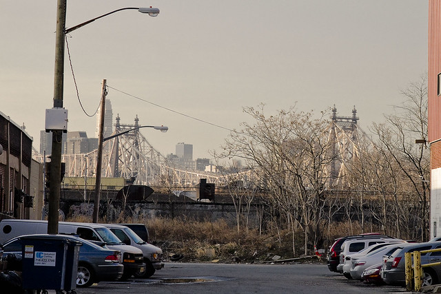
– photo by Mitch Waxman
Cavorting along in that neighborhood which once hosted the titan works of the Waldes Koh-I-Noor mill, where relict rail tracks reach up mercilessly through the asphalt of modern times, your humble narrator was chasing a shot of mighty Queensboro in the distance- illuminated by the rays of a setting sun.
My path brought me to the lightly travelled and seldom commented upon Davis Court.

– photo by Mitch Waxman
An industrial street lined by warehouses both old and new, my attention suddenly became fixed upon these six sandwiches of dubious origin affixed upon the ground.
They appeared to be a sextuplet of jelly sandwiches, but one can never be sure about such things until a bite has been taken- which I was unwilling to do.

– photo by Mitch Waxman
It cannot be explained to you, lords and ladies of Newtown, why this arrangement of comestibles struck me as sinister. Perhaps it was the abandonment of perfectly edible food to the nocturnal scavengers which roam the creek lands, a beady eyed and squealing army which emerges from cracks and from other hidden apertures only when the burning thermonuclear eye of god itself has sunken below the horizon.
Perhaps it was the sandwich arrangement, I cannot say, but repulsion ruled my thoughts.
Feeling faint, your humble narrator moved on.
dim entity

– photo by Mitch Waxman
On the 24th of February, a Newtown Pentacle posting was offered in which description of an astounding demolition which had occurred along 30th street in Long Island City, and whose purpose was to clear the way for a gargantuan FedEx trucking depot and shipping center. Attempting to describe the sheer scale of this to friends and Our Lady of the Pentacle simply proved that words would be inadequate to convey the scale of it all.
So, a humble narrator went back, and did a little bit of climbing.

– photo by Mitch Waxman
Having once been a child in Brooklyn, you humble narrator learned to climb the urban landscape like a monkey. This skill is something that still comes in handy, especially when something which needs photographing is behind a ten foot tall plywood construction fence. The shot above is a “stitched panorama” which incorporates around 16 individual exposures into a single image- encouragement is offered to click through to the largest incarnation of this shot at flickr (click here) to appreciate the massiveness of the footprint.
Click here to see it on a google map.

– photo by Mitch Waxman
From the decking of the Borden Avenue Bridge, you can see that the construction site extends all the way to the Dutch Kills tributary of the malign Newtown Creek. FedEx must need an awful lot of space.
Wonder why?

– photo by Mitch Waxman
Well to begin with, the entirely coincidental condemnation and demolishing of the FedEx World Service Center building in Manhattan (528-556 West 34th Street) to make room for the Hudson Yards residential development has robbed the shipping giant of certain capabilities. My guess, and it’s a guess, is that they were offered Queens instead.
And once again, Manhattan exports its problems to Queens, I guess.

– photo by Mitch Waxman
When this site has been mentioned, those who live and work in Queens get a wild look in their eyes. They ask “Wait, where will all those trucks go when heading into Manhattan?”. Sure, they’ll be taking truck routes, but what happens when they bottleneck at Queens Plaza, the Midtown Tunnel, or the Triborough? Care to guess?
What about the tractor trailers leaving from LaGuardia and Kennedy, how will they get to Long Island City?

– photo by Mitch Waxman
A bit of that climbing talent bragged about at the beginning of this posting, and a switch of POV to Hunters Point Avenue brings you this “stitched panorama” of the rubble beyond the fence. Notice the lack of water being sprayed on the shattered masonry, or any attempt at dust abatement, and remember that the factories which stood here for nearly a century adjoin the monstrous pollution of the Dutch Kills tributary.
This is no land that the site stands on either, rather it’s a construct. This area was filled in by Michael Degnon in the early 20th century with rubble from the Belmont Tunnel construction, and that the bulkheads which defined the modern shape of Dutch Kills were only installed in 1914 by the United States Army Corps of Engineers. This rubble is coated with a century worth of “the colour”.

– photo by Mitch Waxman
Around thirty or forty feet down, the waters of the Newtown Creek gurgle about boulder and gravel, and around the wooden piles which the concrete mastabas of modernity stand upon. The Creek is eternal, and water always- inevitably and eternally and patiently- wins.
Like many things around the Newtown Creek, and Queens in particular, you must just accept the decisions of your betters in Manhattan- I guess. They wish to install playgrounds for the idle rich along the Hudson, erect fanciful condominiums for their comfort, and soaring office towers to administer and employ them. Why should those of us in Queens complain, when they export their waste, their trucking facilities, or their garbage to us?
The needs of the many outweigh the needs of the few, I guess?
ALSO:
March 6th, as in tonight

blissville update

– photo by Mitch Waxman
Just in case you were wondering, not too much new to report on the oil situation in Blissville Queens, which is found on the northern shore of the lamentable Newtown Creek. Our friends at Riverkeeper continue to investigate, as do everyone’s friends at the State DEC. Conversation with highly placed members of both organizations indicate that they have people working on it.
These photos from the beginning of February in 2012 would seem to dispute that. Compare to the same area in August 2011.

– photo by Mitch Waxman
The conversations were informal, and were initiated by your humble narrator. Concurrently, I’m not going to “report” the substance of these exchanges yet, as I’m not “that kind” of blogger. “That kind” would seek to embarrass or denigrate the process and participants for puerile amusement and or self advancement. This is not the case, and I draw a line between what a source tells me privately versus publicly. Suffice to say that things are moving along and that you catch more flies with honey than with vinegar.
The Newtown Creek Alliance is aware of the issue as well, and we are working on it.

– photo by Mitch Waxman
Some of you may have noticed that I said “we” referring to NCA, and in accordance with some standard of full disclosure which only one such as myself adheres to- the group has awarded me the title of “Historian”. I’m picking up the fallen banner of my friend and mentor, Bernie Ente, and will strive to earn the honor by continuing to reveal the occluded history of this place.
The initial assessment of the leak, as presented in the posting “oil in queens” back in December of 2011 has garnered little attention from the mainstream press. The sole venue which ran a story on it is the DNAinfo website, their posting can be accessed here. If this was Manhattan, I’d be fighting the NYTimes for access.
But seriously, who cares anything about Queens?
ALSO:
March 5th, as in tonight:
Riverkeeper and NCA ask: How’s the Water? How’s Newtown Creek?
Join Riverkeeper and the Newtown Creek Alliance for a presentation on water quality in the Hudson River Estuary and its tributaries, focusing on the waters around Manhattan Island and in Brooklyn’s Gowanus Canal and Newtown Creek.
March 5, 2012, 7:30PM to 9:30PM
Brooklyn Brewery, 79 North 11th Street, NY map
and March 6th, as in Tuesday
garret studio

– photo by Mitch Waxman
There’s a whole lot of dredging going on.
It seems that the Harbor of NY itself is desirous of silting up, which would destroy its value as a commercial port. What the Harbor is actually doing is attempting to revert to the shallow estuary it once was, following the methodologies set down by nature, but this would impede navigation and be catastrophic for both the economic and urban activities of man.
When the terrorist is nature incarnate- the Marines, Army, or Air Force can’t help you at all. Forget about Homeland Security, for any problem that involves a whole lot of dredging you send in the United States Army Corps of Engineers!
from nan.usace.army.mil
New York Harbor encompasses approximately two-dozen separately authorized and maintained Federal navigation channels. These projects, whose authorized depths vary from 8 feet to 50 feet, along with the privately operated berthing areas, generate approximately 1 to 2 million cubic yards of sedimentary material annually from maintenance dredging alone. Further, several of these channels are either under construction or in plans for deepening in the upcoming years to accommodate larger vessels calling at the port. The construction of these deeper channels will also generate substantial amounts of dredged material. The DMMP process seeks to identify and implement options to manage the material generated from both the federal and non-federal maintenance and deepening of the Port through the year 2065.

– photo by Mitch Waxman
The USACE has over the course of time reshaped the course of mighty rivers, eradicated tall mountains, and they’ve even bent the Helegaat to its will. The USACE has powers and abilities far beyond those of ordinary men, which they employ in a neverending battle for the American Way. In the case of the modern dredging observed around the Kill Van Kull and Port Newark, the Corps are ensuring that the soft bottom of the waterway will be deep enough to allow an enormous class of cargo ship called “Panamax” to safely navigate the port.
This involves the movement and dispersal of a whole lot of dredging spoils.
from nytimes.com
For more than a decade, workers using giant digging machines have scooped up enormous mounds of rock, clay, sand and silt from the waters around New York to deepen the shipping channels to accommodate giant cargo vessels that will navigate the widened Panama Canal starting in the middle of the decade.
The dredging has produced millions of cubic yards of muck.

– photo by Mitch Waxman
There’s a few different machines which are involved in this sort of thing, and not just the claw bucket derricks which are filling barges in these shots. Lots of private contractors actually do the work, with a few key players getting the lion’s share.
Some effort has been made to find shots of these various devices- photos which a humble narrator clearly remembers shooting- but they are currently lost amongst the nearly 20,000 shots which I’ve obtained and uploaded for usage at Newtown Pentacle in the last few years.
As far as my hard drives go, there’s a whole lot of dredging that needs to be done.
from epa.gov
The Administrator of the EPA and the Secretaries of the Army and of Transportation agreed to close the Mud Dump Site for disposal of dredged material in their 1996 Three Party Letter. This was in response to surveys that had shown that contaminants in the dredged material caused sediment toxicity and bioaccumulation effects in estuarine organisms. For example, worm tissue at the disposal site was found to accumulate dioxins, and both dioxin and polychlorinated biphenyl (PCB) contamination was found in lobsters. Individual elements of the aforementioned data do not prove that sediments within the HARS are imminent hazards to the New York Bight Apex ecosystem, living resources or human health. However, the collective evidence presents cause for concern, and justifies the finding that a need for remediation exists, that the site is Impact Category I (see, 40 CFR 228.10), and that the site should be managed to reduce impacts to acceptable levels.

– photo by Mitch Waxman
There’s little controversy around the idea that the government needs to keep these channels open, and lots of acrimony about what to do with the often toxic materials which are brought up to the surface. According to most sources, the sediment which rests on the floor of the harbor contains a cocktail of industrial leave behinds. Concerns are also voiced about sediments which reenters the water column and proceeds to swirl and shoal in new places.
Which brings us back to “What do you do with a whole lot of dredging spoils?”.
from nan.usace.army.mil
To accommodate the increasing need for the disposal of the assorted material, The Office of Supervisor of New York Harbor was established by an act of Congress in 1888. The Harbor Supervisor, acting through the Office of the Chief of Engineers (of the U.S. Army Corps of Engineers), was responsible for the designation of specific disposal sites and for ensuring that ocean disposal would not be detrimental to navigation or pollute adjacent beaches (Williams and Duane, 1974).
Materials including garbage, city refuse, cellar dirt (natural rock and soil excavated during building construction), floatable materials, and sediments derived from dredging during the maintenance, deepening and construction of new channels in New York Harbor, were dumped at specific locations in the New York Bight Apex. Records indicate that approximately six locations were selected to receive this wide range of materials. As the material accumulated at these locations, the sites were relocated farther seaward where increased water depths alleviated concerns of potential navigation threats posed by accumulation of materials.
Hydrographic data spanning the period from 1845 to 1934 revealed that mounds of material were being formed in the general area of the submerged Hudson Shelf Valley (Christiaensen Basin), the Ambrose Light Station (Diamond Hill), and the Scotland Light Buoy. By 1914, shoaling at one of the sites reserved for dredged material and cellar dirt became a critical factor in the decision of the Supervisor of New York Harbor to separate the site usages and thus segregate the material being disposed at each site.

– photo by Mitch Waxman
Were there just some seemingly limitless abyss, an infinity of dark and cold which might just swallow up the sins of the world. Indigo, this ideal dump would boast colossal pressure and unimaginable cold whose combination might vouchsafe whatever poisons you might secret away against future discovery. Some sunken Grand Canyon, which might be neither too far, nor too close.
This would be a great place, a historic one, to dispose of a whole lot of dredging spoils.
from wikipedia
The Hudson Canyon is a submarine canyon that begins from the shallow outlet of the estuary at the mouth of the Hudson River. It extends out over 400 nmi (740 km) seaward across the continental shelf finally connecting to the deep ocean basin at a depth of 3 to 4 km below sea level. It begins as a natural channel of several kilometers width, starting as a 20-40 m depression at Hudson Channel southward from Ambrose Light, then carving through a deep notch of about 1 km depth in the shelf break, and running down the continental rise. Tidally associated flows of about 30 cm/s (1 km/h) up and down the deeper parts of the canyon have been recorded. As silt, sand and mud are carried down the Hudson River, they flow into the canyon and out into the deep sea.
The Hudson Canyon proper is located about 100 miles (160 km) east of the mouth of the Hudson River off the New Jersey coast. Its walls rise three-quarters of a mile from the canyon floor making it comparable to the Grand Canyon, whose cliffs are over a mile deep and 270 miles (430 km) long. It is the largest known ocean canyon off the East Coast of the United States, and one of the largest submarine canyons in the world. The canyon is located near the 100 meter isobath on the continental shelf and is 2,200 m (7,217 ft) deep at the base of the continental slope. Over an 80 km (50 mi) distance, the average slope of the canyon floor is 1.5°. At this point the canyon is as much as 12 km (7.5 mi) wide (from east rim to west rim) and as much as 1,100 m (3,609 ft) deep from canyon rim to canyon floor across the continental slope. The floor of the canyon is less than 0.5 km (1,640 ft) wide across the upper part of the slope and broadens to about 0.9 km (~3,000 feet) at the base of the slope.

– photo by Mitch Waxman
The deeps have been explored a bit, but not enough, by the federal agency NOAA. They report that the canyon is littered with sunken sailing ships, indian canoes, even ocean going diesel freighters of relatively recent vintage. Can you imagine, all there is, that might be down there?
from pubs.usgs.gov
The 150-km-long Hudson Shelf Valley, the largest physiographic feature on the mid-Atlantic continental shelf, bisects the New York Bight region. The Valley is the submerged seaward extension of the ancestral Hudson River drainage system that, unlike other valleys on the Atlantic shelf, has not been filled with sediment. A survey of the topography and backscatter intensity of the valley has been carried out using a Simrad Subsea EM 1000 multibeam sea floor mapping system. The valley head is located in a broad shallow basin and extends offshore 5-40 m below the shelf surface to a seaward terminus at a shelf-edge delta. The valley can be divided into upper, middle, lower and outer sections based on the topography, surficial sediments, and drainage pattern. The middle valley is characterized by 5 local topographic lows along the valley axis that have relief of 3-11 m below the valley floor. The northwestern portion of the study area has been affected by disposal of dredged and other materials since the late 1800’s. Part of this area has been designated as the Historic Area Remediation Site (HARS). The sea floor of the HARS is being remediated by placing at least a one-meter cap of clean dredged material on top of the existing surface sediments that exhibit varying degrees of degradation. A large field of sand waves is located in the lower valley in 70-80 m water depth that cover an area approximately 30 km long and 4 km wide. This sand wave field is hypothesized to be part of a flood deposit that formed as a result of the break-out of glacial lakes in upstate New York approximately 13,500 years BP. In the eastern-most part of the survey area in water depths greater than about 110 m, the sea floor is marked by long narrow northeast-southwest-trending grooves that are interpreted to be iceberg scour marks.
ALSO:
March 5th, as in Monday night:
Riverkeeper and NCA ask: How’s the Water? How’s Newtown Creek?
Join Riverkeeper and the Newtown Creek Alliance for a presentation on water quality in the Hudson River Estuary and its tributaries, focusing on the waters around Manhattan Island and in Brooklyn’s Gowanus Canal and Newtown Creek.
March 5, 2012, 7:30PM to 9:30PM
Brooklyn Brewery, 79 North 11th Street, NY map
and March 6th, as in Tuesday
Project Firebox 34

– photo by Mitch Waxman
You don’t see many of this sort of Firebox anymore, which combined Police and Fire intercoms in a single unit. A humble narrator clearly remembers school assemblies (P.S. 208 on Avenue D) in which redoutable members of both services offered advice on how and when to appropriately use these fireboxes in terms of emergency.
One also recalls the “give a hoot, don’t pollute” stickers on garbage pails and being urged to turn off lights when leaving the room. Bellbottom corduroy pants also figure heavily into such memories.


