Archive for the ‘Brooklyn’ Category
bodily dislodgement
Friday
– photo by Mitch Waxman
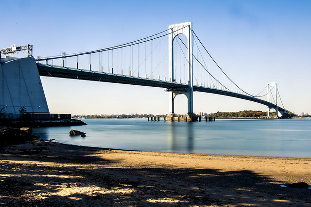
October 21st, and I was continuing my exploration of a few spots in College Point and Whitestone which seemed promising. These were located during a session I spent with Google Maps’ street view feature. The 1961 Throgs Neck Bridge is what it depicts. The Google map said I was in a dog park, but it was actually just a parking lot alongside a parkway.
The hour was growing a bit late, and plans to meet Our Lady of the Pentacle back in Astoria were in the offing, so I packed up my troubles in the old kit bag. Yes, I did, indeed, “smile, smile, smile.”
For those of you under the age of 1,000, that’s a jokey reference to this song.

– photo by Mitch Waxman
October 22nd saw me in Flushing, at the Queens Botanical Garden.
There were pumpkins.

– photo by Mitch Waxman
October 25th and I was scheduled to spend a day with one of my closest friends driving around Southern Brooklyn, but it was very foggy when I left the house about 8:30 a.m. My ultimate meetup destination was in Park Slope, and there’s an obvious way to get there by car from Astoria, one which unfortunately involves sitting in a lot of Manhattan bound traffic on a certain expressway that connects Brooklyn and Queens.
I decided to go there via the less obvious but more interesting route, by driving to Ridgewood and then hanging a right and then a left or two in Bushwick and then proceeding through that central part of Brooklyn which nobody ever talks about these days. Along my way to the first right in Ridgewood, I crossed Newtown Creek and couldn’t resist a shot or two of the Grand Street Bridge all cloaked up in mist.

– photo by Mitch Waxman
The new car has a moon roof. I don’t know what the actual difference between a sun roof and a moon roof is, but there you are. As I was driving along, whenever I got stuck at a light, I’d shove the camera up through the moon roof and turn the camera’s LED screen to a convenient angle so I could compose and record a quick shot.
That’s Brooklyn’s Grand Army Plaza, all fogged up.

– photo by Mitch Waxman
I did the same thing with the camera and moon roof on my way home. The fog had cleared by the afternoon, and the burning thermonuclear eye of God itself had burst into view. I was driving down Flatbush Avenue, this time headed in the direction of the aforementioned expressway betwixt Brooklyn and Queens.
I’ve been doing this sort of shot a bunch the last couple of weeks, as I’ve been driving a lot since receiving the car. It’s an interesting perspective for me, since the position of the lens to the car’s roof as it stands relative to the ground – if it were “eye level” – would indicate that I’m about six inches taller than I actually am.

– photo by Mitch Waxman
An errand got me off the expressway and into the Woodside and Jackson Heights zone, where I had to weave an automotive path through the various “improvements” to traffic flow offered by the City in recent years. While driving down Roosevelt Avenue, a splotch of pigeon scat landed on the hood of my car, and I decided that it would be good idea to close the moon roof.
Hey, they say that’s lucky, having a pigeon poop on you.
“follow” me on Twitter- @newtownpentacle
Buy a book!
“In the Shadows at Newtown Creek,” an 88 page softcover 8.5×11 magazine format photo book by Mitch Waxman, is now on sale at blurb.com for $30.
thumping rattle
Thursday
– photo by Mitch Waxman
October 20th and a humble narrator had just received the most critical bit of equipment needed to enable his “escape from New York.” A car.
All of these years in Queens, I’ve been a dedicated pedestrian and married to mass transit. I’ve always opined that having a car in Astoria is more of a curse than a boon. It was actually cheaper for me to use ride shares or cabs when I needed a ride than it was to own one.
I’m moving to America, and quite literally to “Mr. Roger’s Neighborhood,” where you cannot exist on the continent without a vehicle so I had to drop the hammer. Placed the order in July, and got a fresh from the factory new car in late October.
– photo by Mitch Waxman
Since becoming hyper mobile and independent of the geographic restrictions which are governed by how far my feet can scuttle, as well as the physical constraints of how long I can carry my photo kit, one has been ranging all over the city. Saying that, what is being missed out on now are the little things that you can’t see when driving along as you’re moving too fast.
After getting my driver’s license reinstated earlier this year, I rented a few different vehicles from Avis and Hertz, looking for a good fit for Our Lady of the Pentacle and myself. The Toyota RAV4 Hybrids rose to the top of my list, and we ordered one from one of the new car dealerships on Northern Boulevard. My accountant opined that even if I bought the thing in Alaska, NYS would still bill me for sales tax since my legal address would still here at the time of purchase, so I bit the bullet. Hopefully, this will be my last really large contribution to the black hole that Albany throws our earnings into to finance its dysfunction.
One of the bits of advice I offer is “if you’re thinking about buying a car, rent the model for a week first, and see if you like it.”
– photo by Mitch Waxman
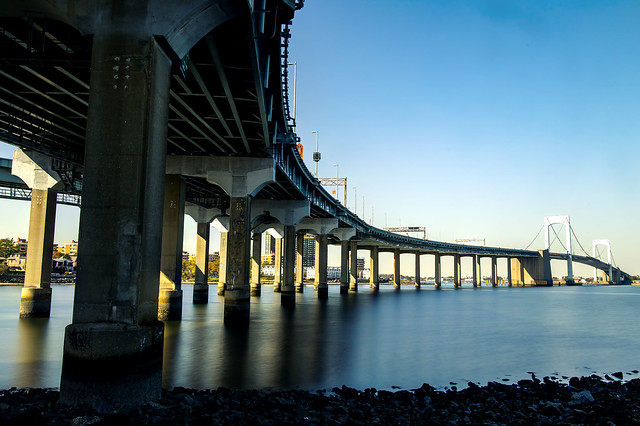
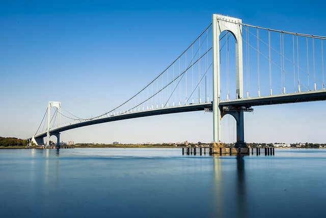
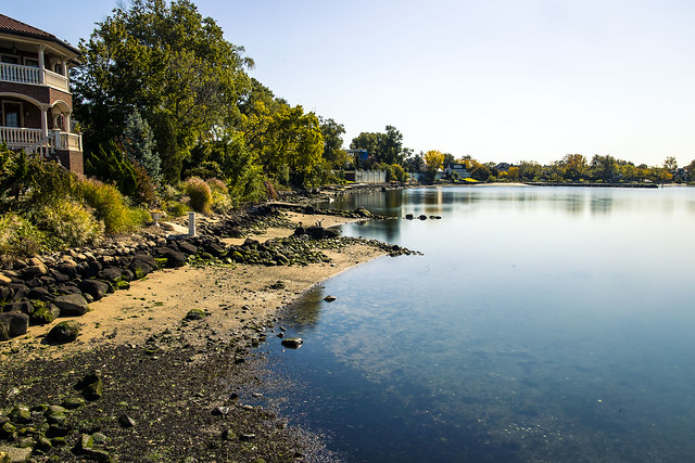
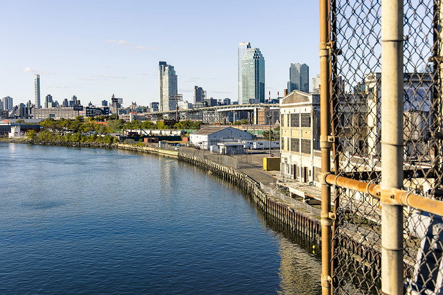
October 21st saw me taking advantage of this new mobility to get a few shots from an area that has always been a little too far off the grid for me to walk around, the coast lines of College Point and Whitestone.
That’s the Bronx Whitestone Bridge pictured above and below.

– photo by Mitch Waxman
Funnily enough, I’ve got more shots of this bridge from the Bronx side than I do the Queens one, due to there being a ferry stop on the Soundview NYC Ferry line in the former location.
I tooled around the area, exploiting several points of view which I had previously scouted out on Google maps. The Google Maps app is a great tool as far as finding potential points of view in areas which are either tangentially known or are complete mysteries. I never would have thought to visit the “Whitestone Bridge Observatory” otherwise, or even suspected such a roundabout street end existed.
– photo by Mitch Waxman
Whitestone seems to be a super wealthy community, with expansive homes that border on “mansion” nestled right up against the water. It looks more like a suburb than it does NYC. You don’t see piles of cast off garbage or debased humans lying in the street, for instance.
I had several photo set ups planned for the day, and since I was in a car, didn’t mind carrying all of the heavy kit which would normally create a limit on how far and wide I could range.
– photo by Mitch Waxman
There aren’t too many Sandy beaches on the East River. I think it’s about 6 or 7, that I know about at least. That’s one of them, above, at Francis Lewis Park. Nice spot.
One kept on heading eastwards, right up and sometimes over the City/Nassau County line.
More on that tomorrow at your – now – hard driving Newtown Pentacle.
“follow” me on Twitter- @newtownpentacle
Buy a book!
“In the Shadows at Newtown Creek,” an 88 page softcover 8.5×11 magazine format photo book by Mitch Waxman, is now on sale at blurb.com for $30.
disreputably nourished
Wednesday

– photo by Mitch Waxman
October 11th saw me conducting a small walking tour for a couple of friends of First Calvary Cemetery.
I haven’t been able to conduct any commercial tours of Calvary for quite a while now, due to a cease and desist letter which the Roman Catholic Church sent me. I actually consider that to be a feather in my cap.

– photo by Mitch Waxman
October 13th was a rainy day, and night, so I lingered at HQ and shot a few portraits of the Bodega across the street from my porch.
I had an invite to a fundraiser party in Williamsburg the next day, and planned on getting to Brooklyn the long way around.
– photo by Mitch Waxman
October 17th, one left HQ and started trekking towards Brooklyn. I didn’t have too much else going on, so a photowalk was on order for the day. The rain was coming and going, but I had an umbrella.
My plan was to walk for three or four subway stops to Court Square, and then use the G line subway to complete the trip.

– photo by Mitch Waxman
Yeah, yeah, yeah. I could have taken the train the whole way from Astoria and just transferred – but where’s the fun in that?
I actually wandered pretty far afield of my intended path, and ended up – as usual – in the neighborhood surrounding Dutch Kills in LIC on my way.
– photo by Mitch Waxman
Foliage. That’s my excuse. Fall foliage.
The party I was heading to was for the Evergreen outfit, which is one of the groups that Newtown Creek Alliance is allies with. They’re a “BID” or Business Improvement District group which advocates for the industrial zone of North Brooklyn. Nice bunch of people, and it was a good party with lots of friends in attendance. In the end, I just walked to Williamsburg from LIC.

– photo by Mitch Waxman
At some point after the party, the rain became somewhat intense, so I made my way to the subway and caught the G.
Y’know what? That was probably the last time that I’d ever be riding the G train. After all, my entire world changed a couple of days later.
“follow” me on Twitter- @newtownpentacle
Buy a book!
“In the Shadows at Newtown Creek,” an 88 page softcover 8.5×11 magazine format photo book by Mitch Waxman, is now on sale at blurb.com for $30.
noxious heap
Tuesday
– photo by Mitch Waxman
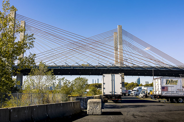
Continuing with the sights witnessed along a longish scuttle on October 8th, a humble narrator found himself crossing the Greenpoint Avenue Bridge and heading towards Brooklyn’s Greenpoint section.
That’s my beloved Newtown Creek in the shot above. About 1.3 miles back from the East River.
– photo by Mitch Waxman
Kingsland Avenue is in the process of being redesigned in response to the opening of Phase 3 of the Newtown Creek Nature Walk at the sewer plant, which has brought lots and lots of pedestrian and bike traffic to the former entirely industrial street. As always seems to be the case these days, NYC DOT’s traffic engineers has managed to imagine up the worst possible design, and implemented it in a piecemeal and inconsistently thought out fashion.
Somebody else’s problem now. I’m done fighting City Hall.
– photo by Mitch Waxman
At the Nature Walk, which hugs the water facing side of the Sewer Plant, the Pulaski Bridge opening for a passing tug was observed.
Somebody recognized me, and I was having a conversation with them while climbing on a fence. They were clearly afraid that I was going to fall in the water while doing so, but there you are.
– photo by Mitch Waxman
The next section of my walk involved attaining the Pulaski Bridge’s pedestrian path. Which carried me back out of Brooklyn and into Queens’ Long Island City section.
One briefly considered hopping on the subway, but it was a beautiful day and I just kept on scuttling.
– photo by Mitch Waxman
One headed eastwards on Jackson Avenue, heading towards Astoria.
“Every time might be the last time.”

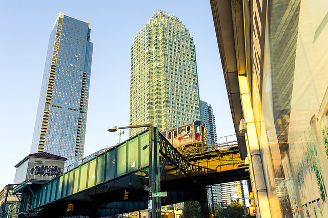
– photo by Mitch Waxman
Queens Plaza has become absolutely unrecognizable at this point. The few remaining industrial buildings and warehouses which survived the reconstruction of the area have finally been consumed by the real estate frenzy.
Tomorrow – something a bit different, at this – your Newtown Pentacle.
“follow” me on Twitter- @newtownpentacle
Buy a book!
“In the Shadows at Newtown Creek,” an 88 page softcover 8.5×11 magazine format photo book by Mitch Waxman, is now on sale at blurb.com for $30.
grassy cobbles
Monday

– photo by Mitch Waxman
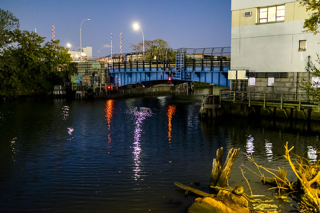
Last week, one described the circumstances of a navigation of Newtown Creek on September 27th during which the photos in today’s, and prior postings, were captured. The small boat I was riding in had been navigated all the way back to the Metropolitan Avenue Bridge by it’s Captain – Carter Craft. There’s still a bit of navigable water beyond this span, a double bascule drawbridge owned and operated by the NYC DOT, but I seldom go back there in anything larger than a rowboat and I don’t do that often at all.
Down Under the Metropolitan Bridge Onramp or DUMABO, that’s how I “tag” anything which I’ve written about this bridge, or the area directly surrounding it in Brooklyn. The English Kills tributary of Newtown Creek is entirely contained within the political boundaries of the Borough of Brooklyn, in its East Williamsburgh section.

– photo by Mitch Waxman
English Kills is entirely hidden from view on the surrounding streets. A once natural waterway canalized by the various Corporate entities which once housed themselves here, and the United States Army Corps of Engineers. From the surrounding streets, you’d never know it was there if it wasn’t for the industrial noises and horrific smell. The odor is not unlike what you’d expect were you were to shit into a bucket of rubber cement thinner, and then set it out to sit in direct sunlight, while a running diesel engine out gassing exhaust. The sound is a “constant din” as in there’s no specific point source for it, rather there’s an atmosphere of noise echoing off the factory and warehouse walls.
The canalized shape of English Kills follows the jigsaws grid of the surrounding streets, which causes its waters to stagnate around the right angled turns. The presence of CSO’s – or Combined Sewer Outfalls – all along Newtown Creek means that the only fresh water entering English Kills comes from these upland drains. This flow is a mix of storm water, road runoff, and sewage. The latter is full of piss and poop, if you need me to point that out. The runoff and storm water washes through the neighborhoods first, carrying garbage and whatever might have dripped out of vehicles passing by on the roadways, and then into the stagnant water column of the tributary.
Because of the stagnation, a bed of sedimentation sits 15-20 feet thick under the surface of the water, sometimes poking out into the air at low tide. The sediments are referred to as “Black Mayonnaise.”

– photo by Mitch Waxman
Historic records suggest that the natural waterway that was once here, prior to colonization by the Dutch, was fed by upland streams and rock springs running down into the waterway’s basin from the highlands surrounding it, in modern day Maspeth, Ridgewood, and Bushwick. It’s the availability of that fresh water bubbling up from the rock springs that drew German beer breweries to establish themselves in these areas. The springs were capped, and the ground water claimed. That was the first industrial nail in the coffin of this part of the larger waterway. Contaminants and pollution from industrial plants literally miles away on the Creek would end up getting pushed back here and since there was nothing tidally pushing back, the bad stuff settled to the bottom. The Black Mayonnaise encountered “here” can be very different from conditions encountered “there,” despite the fact that it’s the same water body. Even on English Kills, the section you’re looking at in the shot above is entirely different from the hellscape found a half mile away in the zone around the apocalyptic Montrose Avenue Railroad Bridge nearby Newtown Creek’s terminus, at Bushwick’s Johnson Avenue.
Few of the modern businesses on English Kills use their maritime bulkheads, once amongst the most valuable in NY Harbor or even the world due to the nearby Evergreen Line Railroad tracks – which are today’s Long Island Railroad Bushwick Branch tracks.

– photo by Mitch Waxman
Open sewers dating back to the Civil War are seen here.
English Kills is the extermination of ration and hope, and a cautionary tale about municipal indifference. The NYC DEP, who operate those CSO drains mentioned above, found themselves under regulatory scrutiny by New York State a few years ago due to the low levels of oxygen present in these waters. The low oxygen situation is caused by sewage bacteria, which they allow into the Newtown Creek via the CSO’s. The answer DEP came up, since doing anything at all about the outflows themselves would be very expensive to the City, was to instead build an aeration system into the waterway. Giant bubble wands, reminiscent of a hobbyist aquarium’s setup, pump air into the water, which causes surface turbulence. These bubbles theoretically cause atmospheric oxygen to diffuse into the water.
The air flow also introduces mechanical energy into the bottom sediments and causes them to rise and coat the shorelines, where the so called black mayonnaise becomes exposed to the air.

– photo by Mitch Waxman
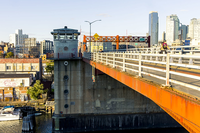
Grand Street Bridge, a swing bridge, is pictured above. The center of that bridge is where the currently undefended border of Brooklyn and Queens is found. If hostilities ever break out, this will be a flash point and no man’s land where campaigns of armed attrition will play out.
Our time on Newtown Creek was nearing an end and my pal Carter captained us back toward Greenpoint, and the Manhattan Avenue Street End where he picked us up earlier in the day. A humble narrator was on an emotional roller coaster, it should be admitted.
“Every time might be the last time.”

– photo by Mitch Waxman
Along our journey back in the direction of the East River, nearly three miles back on the Maspeth side, we saw a guy fishing in Newtown Creek.
Tomorrow, more! And then even more! More all the time, now with extra more! Now – more than ever – more!
“follow” me on Twitter- @newtownpentacle
Buy a book!
“In the Shadows at Newtown Creek,” an 88 page softcover 8.5×11 magazine format photo book by Mitch Waxman, is now on sale at blurb.com for $30.


