Archive for the ‘Williamsburg Bridge’ Category
gray city
It’s complicated, man…
– photo by Mitch Waxman
A humble narrator is known for his somewhat quixotic inflections of mood by those who know him privately. It’s not exactly “manic depressive” in the clinical sense, but it often doesn’t seem far off. With me, it’s more “happily content and patient / consumed with red hot anger and resentment.” I don’t know why, maybe my parents loved me too much, or not enough. Can’t say.
Either way, I’m often a hot mess and the only way out of feeling bad is to get out and do something. Work, hard work, is the answer to almost every problem – as I see it. In many ways, I’m a lot like that horse Boxer from Orwell’s “Animal Farm.”

– photo by Mitch Waxman
Since nothing grinds my gears worse than a summer cold, an experience which I recently suffered through, one has been hitting the terrestrial pavement and the deck plates of boats as hard as I can for the last couple of weeks in pursuance of working harder. Now, the odd thing is this – I haven’t been to the Newtown Creek.
Normally, Newtown Creek is my happy place. Also, being exposed to that waterway bolsters my immune system and generally keeps me from getting sick and or contracting a summer cold. Oddly, however, I haven’t felt Queens calling for me to go there in a few weeks.

– photo by Mitch Waxman
It’s not that I’m bored with the place – far from it. There’s just some little bird chirping away inside my “happily content and patient / consumed with red hot anger and resentment” state of mind that’s saying “explore” and is thinking about the far horizons.
Upcoming Events and Tours
Saturday, June 25, 10:30 a.m. – 1:00 p.m. –
The Insalubrious Valley of the Newtown Creek,
with Brooklyn Brainery. Click here for more details.
Sunday, June 26, 11:00 a.m. – 1:00 p.m. –
Calvary Cemetery Walking Tour,
with Atlas Obscura. Click here for more details.
“follow” me on Twitter- @newtownpentacle
last stages
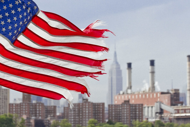
The modern day East River in today’s post, which bums me out.

– photo by Mitch Waxman
One such as myself once absolutely loved the idea of riding the East River Ferry. As a matter of fact, I seem to enjoy all ferry rides, presuming that the deck is accessible and amenable to photographic pursuits. These days, the actual experience of doing so brings on depressive episodes. One of the problems with the “historian” point of view is that you tend to realize that whatever rises must also fall, and that bills must ultimately be paid. That is why we all toil and labor, to service debts, and the City of New York is currently racking up a hell of a tab.
Recently, the Alice Oldendorf bulk cargo ship was observed at work, making a delivery to a concrete plant at the Brooklyn Navy Yard as I rode the aforementioned ferry.

– photo by Mitch Waxman
The ship hosts a series of cranes and conveyors which unload her holds, producing the cyclopean mounds of sand and gravel witnessed above. It’s nice to know that at least some part of ancient Williamsburg still hosts a working waterfront, or at least a working waterfront that is engaged in the production of something other than artisanal pickles.
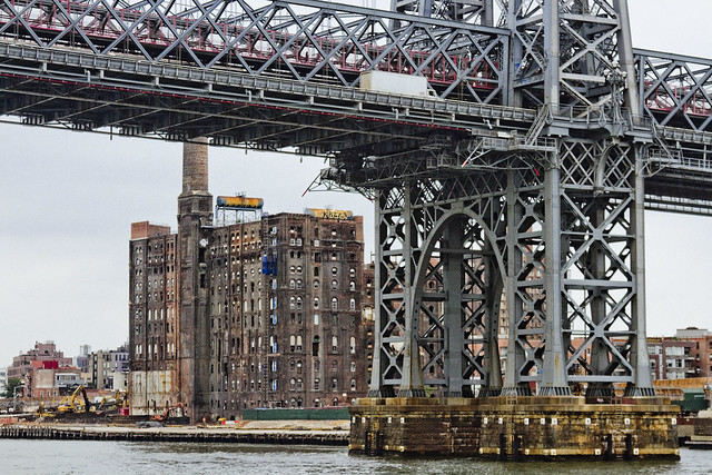
– photo by Mitch Waxman
One cannot help but drop his jaw whenever the former Havemeyer or Domino Sugar plant site comes into view. It is being redeveloped as a residential structure – more luxury condos for the children of the rich to dwell within. The question of what will happen to these structures when NYC slides backwards into an era of degeneracy and decay is one few ask.
Any historian will tell you that it’s a cyclical thing here in the megalopolis, one that flips back and forth on a roughly forty year cycle which can be directly correlated to rates of crime, and that the City’s current upswing began in the late 1990’s – reversing a decline process that started shortly after the Second World War.
Rich people tend to move away from the City center when things get hairy. The rest of us are kind of stuck here.

– photo by Mitch Waxman
Williamsburg is officially lost as a point of interest for me. Bland boxes of steel and glass will extend all along the East River soon enough, stretching from the former industrial heartland once called “America’s Workshop” in Long Island City all the way through the Gold Coast of North Brooklyn to the Williamsburg Bridge. Criminals are already beginning to focus their attentions on this area, just as they did in the age of industry. Why? Because predators go where the prey is.
It’s cliché to even comment on it anymore, one realizes.

– photo by Mitch Waxman
Scenes long familiar, lost. The wilderness of the oligarchs is upon us, and deep in the woods – wolves howl to celebrate and delight. The nobles will be safe in their keeps, but the peasants – we’re on our own.
“follow” me on Twitter- @newtownpentacle
Upcoming Tours –
August 2nd, 2015
The Insalubrious Valley of the Newtown Creek – Bushwick & Mapeth Walking Tour
with Newtown Creek Alliance, click here for details and tickets.
August 8th, 2015
13 Steps Around Dutch Kills – LIC Walking Tour
with Atlas Obscura, click here for details and tickets.
As detailed in this recent post, my camera was destroyed in an accident.
For those of you who have offered donations to pay for its replacement, the “Donate” button below will take you to paypal. Any contributions to the camera fund will be greatly appreciated, and rewarded when money isn’t quite as tight as it is at the moment.

lean notary
Shots from all over the edge of a Long Island.

– photo by Mitch Waxman
Over at the Brooklyn Navy Yard, a cargo ship was unloading a load of concrete manufacture supplies. The ship was performing the unloading process all by itself, with a series of swing out booms and cranes with mechanical buckets and shovels all busily employed. These shots were all gathered during the Solstice, when everything looks a bit ethereal, as the burning thermonuclear eye of god itself is in its position of annual primacy over the megalopolis.

– photo by Mitch Waxman
You can’t see the Williamsburg Bridge lit like this during winter time, as the angle of the burning thermonuclear eye of god itself is considerably less efficacious. My camera’s color and light meters were all over the place when I shot these, as what would normally be thought of as afternoon lighting lasted well past 6 pm – I think this particular shot was from around 6:30-7. Notice the wild angle that the light is falling at – longest day of the year light.

– photo by Mitch Waxman
This is from pretty late in the day, as the burning thermonuclear eye of god itself is finally slipping down past the shield wall of Manhattan. It depicts my beloved Newtown Creek, as shot from a familiar spot on the Pulaski Bridge. It’s a handheld shot, and is a bit grainy, but there was just something wonderful about the scene – couldn’t resist.
“follow” me on Twitter- @newtownpentacle
There are two Newtown Creek walking tours coming up.
Saturday, June 28th, The Poison Cauldron
With Atlas Obscura, click here for tickets and more info.
Sunday, June 29th, The Insalubrious Valley
With Brooklyn Brainery, lunch included, click here for tickets and more info.
approaching triumph
Infrastructure pornography, gratuitous and forbidding, in today’s post.
Also, I’ll be at Brooklyn Brainery on February 27th presenting “the Newtown Creek Magic Lantern Show.”

– photo by Mitch Waxman
Gaze upon the terrible scale of the Verrazano Narrows Bridge, connecting Brooklyn with… Staten Island… Bridges are on my mind today, especially the ones that connect Long Island with other extant land masses scattered about the archipelago.
Today will be just a lot of photos, and your humble narrator will be taking advantage of the short interval of warmth offered today. Out and about, looking at things- that’s me.
from wikipedia
The bridge is owned by the City of New York and operated by MTA Bridges and Tunnels, an affiliate agency of the Metropolitan Transportation Authority. Interstate 278 passes over the bridge, connecting the Staten Island Expressway with the Gowanus Expressway and the Belt Parkway. The Verrazano, along with the other three major Staten Island bridges, created a new way for commuters and travelers to reach Brooklyn, Long Island, and Manhattan by car from New Jersey.
The bridge was the last great public works project in New York City overseen by Robert Moses, the New York State Parks Commissioner and head of the Triborough Bridge and Tunnel Authority, who had long desired the bridge as a means of completing the expressway system which was itself largely the result of his efforts. The bridge was also the last project designed by Chief Engineer Othmar Ammann…

– photo by Mitch Waxman
East River Bridge #1, or East River Suspension Bridge #1, or Brooklyn Bridge from Brooklyn.
from nyc.gov
The Brooklyn Bridge opened in 1883. At the time, it was the longest suspension bridge. It has been designated a National Historic Landmark by the National Park Service, and a New York City Landmark by the Landmarks Preservation Commission.

– photo by Mitch Waxman
East River Bridge #3, or Manhattan Bridge, from the water.
from nyc.gov
The youngest of the three DOT East River suspension bridges, construction began on October 1, 1901. The bridge opened to traffic on December 31, 1909 and completed in 1910. The Bridge’s total length is 5,780 feet from abutment to abutment at the lower level; and 6,090 feet on the upper roadways from portal to portal. Its main span length is 1,470 feet long and each of its four cables is 3,224 feet long. The Bridge was designed by Leon Moisseiff (1872-1943)…

– photo by Mitch Waxman
East River Bridge #2, Williamsburg Bridge, from Manhattan.
from nyc.gov
When it opened in 1903, the Williamsburg Bridge was the longest suspension bridge in the world, with a span of 1600 feet and a total length of 7308 feet and the first with all-steel towers. The 310-foot steel towers support four cables, each measuring 18_ inches in diameter and weighing 4,344 tons. In all, nearly 17,500 miles of wire are used in the cables that suspend the bridge 135 feet above the East River. The massive stiffening trusses were designed not only to withstand high winds, but also to support rail traffic on the deck.

– photo by Mitch Waxman
East River Bridge #4, Queensboro Bridge, from Long Island City.
from nyc.gov
The bridge was constructed between 1901 and 1909 and was opened to the traffic on June 18, 1909. A collaboration between the bridge engineer Gustav Lindenthal (1850-1935) and architect Henry Hornbostel, the main bridge is 3,725 feet long, the longest of the East River Bridges. The overall length of the bridge including the Manhattan and Queens approaches is 7,449 feet.
The site is an ideal location for a bridge as Roosevelt Island provides a convenient footing for the piers. Seventy-five thousand tons of steel went into the original bridge and its approaches. Its original cost was about $18 million, including $4.6 million for land. At the time of completion, it was not only the longest cantilever bridge in the United States, but also was designed for heavier loads than any other bridges.

– photo by Mitch Waxman
Welfare Island, aka Roosevelt Island Bridge, from Roosevelt Island looking towards Queens.
from nyc.gov
The Roosevelt Island Bridge is a tower drive, vertical lift, movable bridge across the East Channel of the East River between the borough of Queens and Roosevelt Island, New York City. The span length is 418 feet. It was known as the Welfare Island Bridge when it was first opened to traffic in 1955.

– photo by Mitch Waxman
Triborough Bridge, aka Robert F Kennedy Bridge, from Astoria, Queens.
from wikipedia
Construction began on Black Friday in 1929, but soon the Triborough project’s outlook began to look bleak. Othmar Ammann, who had collapsed the original design’s two-deck roadway into one, requiring lighter towers, and thus, lighter piers, saving $10 million on the towers alone, was enlisted again to help guide the project. Using New Deal money, it was resurrected in the early 1930s by Robert Moses, who created the Triborough Bridge Authority to fund, build and operate it. The completed structure was opened to traffic on July 11, 1936.
The total cost of the bridge was more than $60 million, one of the largest public works projects of the Great Depression, more expensive even than the Hoover Dam. The structure used concrete from factories from Maine to Mississippi. To make the formwork for pouring the concrete, a whole forest on the Pacific Coast was cut down.

– photo by Mitch Waxman
Hell Gate Bridge, also from Astoria, Queens.
from wikipedia
The Hell Gate Bridge (originally the New York Connecting Railroad Bridge or The East River Arch Bridge) is a 1,017-foot (310 m)[3] steel through arch railroad bridge in New York City. The bridge crosses the Hell Gate, a strait of the East River, between Astoria, Queens and Wards Island in Manhattan.
The bridge is the largest of three bridges that form the Hell Gate complex. An inverted bowstring truss bridge with four 300-foot (91.4 m) spans crosses the Little Hell Gate (now filled in); and a 350-foot (106.7 m) fixed truss bridge crosses the Bronx Kill (now narrowed by fill). Together with approaches, the bridges are more than 17,000 feet (3.2 mi; 5.2 km) long.
“follow” me on Twitter- @newtownpentacle
marching things
Infrastructure geekery today.

– photo by Mitch Waxman
The center of the Williamsburg Bridge span offers a clearance to river going vessels of about 135 feet.
A building story is conventionally calculated as being around 10-12 feet, so that makes the Williamsburg Bridge tall enough to fit a roughly 11-12 story building under the apogee of its arc, water towers notwithstanding. That gives us a bit of an idea about the sort and size of maritime vessels which used the mercantile river during the late 19th and early 20th century. Remember that engineers always work around restrictions, and inadvertently create standards when they do.
from wikipedia
Construction on the bridge, the second to cross this river, began in 1896, with Leffert L. Buck as chief engineer, Henry Hornbostel as architect and Holton D. Robinson as assistant engineer, and the bridge opened on December 19, 1903 at a cost of $24,200,000

– photo by Mitch Waxman
A 75,000 ton pile of steel, we call it Queensboro, and this deck is around 130 feet over the water. When it went up in 1909, there were still concerns about navigability for warships and other large ocean going vessels moving between the Navy Yard in Williamsburg and Long Island Sound (via Hells Gate). This has never been the front door for NY Harbor though, most mariners prefer the shallow but safer route which carries them through Gerritsen Bay and the Narrows, which we call the Ambrose Channel, to Jamaica Bay and the open ocean.
from wikipedia
Serious proposals for a bridge linking Manhattan to Long Island City were first made as early as 1838 and attempts to finance such a bridge were made by a private company beginning in 1867. Its efforts never came to fruition and the company went bankrupt in the 1890s. Successful plans finally came about in 1903 under the city’s new Department of Bridges, led by Gustav Lindenthal (who was appointed to the new position of Commissioner of Bridges in 1902), in collaboration with Leffert L. Buck and Henry Hornbostel, designers of the Williamsburg Bridge.

– photo by Mitch Waxman
149 feet over the water, Manhattan Bridge offers a significant amount of clearance to shipping, nearly 20 feet more than its northern brethren. Admittedly, this has always been a busier part of the river than that spanned by Queensboro and Williamsburg, but I’ve always wondered why East River Bridge 2 (MB) was built higher than 3 (WB) and 4 (QB). I’m sure the answer is pedantic, and will likely be depressing.
from wikipedia
The bridge was opened to traffic on December 31, 1909 and was designed by Leon Moisseiff, who later designed the infamous original Tacoma Narrows Bridge that opened and collapsed in 1940. It has four vehicle lanes on the upper level (split between two roadways). The lower level has three lanes, four subway tracks, a walkway and a bikeway. The upper level, originally used for streetcars, has two lanes in each direction, and the lower level is one-way and has three lanes in peak direction. It once carried New York State Route 27 and later was planned to carry Interstate 478. No tolls are charged for motor vehicles to use the Manhattan Bridge.
“follow” me on Twitter- @newtownpentacle


