Archive for the ‘Maritime Sunday’ Category
sight within

– photo by Mitch Waxman
Maritime Sunday is here once again, and this time around your Newtown Pentacle is focusing in on something most New Yorkers wouldn’t believe exists within the five boroughs- graving or dry docks. These shots are of the Cadell yard, along the Staten Island border formed by the Kill Van Kull.
from wikipedia
A floating drydock is a type of pontoon for dry docking ships, possessing floodable buoyancy chambers and a “U” shaped cross-section. The walls are used to give the drydock stability when the floor or deck is below the surface of the water. When valves are opened, the chambers fill with water, causing the drydock to float lower in the water. The deck becomes submerged and this allows a ship to be moved into position inside. When the water is pumped out of the chambers, the drydock rises and the ship is lifted out of the water on the rising deck, allowing work to proceed on the ship’s hull.

– photo by Mitch Waxman
Tugs, in particular, take a lot of abuse. Towing hundreds of millions of tons through choppy waters puts terrific strain on their hull and superstructure. Just like the family car, they occasionally need to head for a garage to be inspected and repaired- or just painted to avoid the corruption of oxidation.
from caddelldrydock.com
CADDELL DRY DOCK AND REPAIR CO., INC (Caddell) accommodates a wide variety of marine vessels on its floating dry docks and piers. The Caddell facility is one of the largest full service shipyards in the New York Metropolitan Area. In addition to our dry docking services, we offer pier side repair work available on our network of eight piers with crane operations able to extend up to 200′ and capable handling loads up to 6500 tons. Caddell has carried on the noble maritime tradition and legacy of a uniquely exceptional shipyard by providing quality and prompt service at competitive prices for the surounding New York City region for more than a century.

– photo by Mitch Waxman
Like a lot of heavy industries, the graving docks have largely left New York City. Large facilities at Atlantic Basin in Red Hook and other places have simply been left to rot away. The ones in Staten Island seem to be hanging on, doing essential work that keeps the harbor moving.
from globalsecurity.org
Building and repairing boats and ships was Staten Island’s most important industry before the First World War. One of the Island’s earliest and most important shipyards belonged to William and James M. Rutan. Their shipyard produced about a 100 schooners and sloops per year. There were 17 shipyards on Staten Island by 1880, located on the North Shore, in Stapleton and in Tottenville. Tugs, propeller yachts and coal barges were built there. US Navy and international shipping in the late 1800s produced a need for large shipyards. They could be found along the Kill van Kull near Mariners Harbor and Port Richmond. In 1901-1902, Townsend and Downey Shipyard built the Meteor III, an imperial yacht for Kaiser Wilhelm. By the 1920s, 18 shipyards employed 6,800 people.

– photo by Mitch Waxman
This is from the Brooklyn Navy Yard, and shows the other sort of drydock, a granite pit outfitted with sea walls and gargantuan pumping mechanisms that can accommodate all but the very largest shipping.
from wikipedia
On the eve of World War II, the yard contained more than five miles (8 km) of paved streets, four drydocks ranging in length from 326 to 700 feet (99 to 213 meters), two steel shipways, and six pontoons and cylindrical floats for salvage work, barracks for marines, a power plant, a large radio station, and a railroad spur, as well as the expected foundries, machine shops, and warehouses. In 1937 the battleship North Carolina was laid down. In 1938, the yard employed about ten thousand men, of whom one-third were Works Progress Administration (WPA) workers. The battleship Iowa was completed in 1942 followed by the Missouri which became the site of the Surrender of Japan 2 September 1945. On 12 January 1953, test operations began on Antietam, which emerged in December 1952 from the yard as America’s first angled-deck aircraft carrier.
The US Navy took possession of PT 109 on 10 July 1942, and the boat was delivered to the Brooklyn Navy Yard for fitting.
This boat was sunk in the Pacific in August 1943 and became famous years later when its young commander, Lt. John F. Kennedy, entered politics.
At its peak, during World War II, the yard employed 70,000 people, 24 hours a day.
middle stature

– photo by Mitch Waxman
It’s Maritime Sunday once again at this, your Newtown Pentacle, and today the focus is on Thornton Towing’s 1600 HP and 1958 vintage “Thornton Bros.” tugboat. Call sign WDD6171, Thornton Bros. is some 25m x 8m in size and has been clocked going as fast as 8 knots.
from wikipedia
Merchant and naval vessels are assigned call signs by their national licensing authorities. In the case of states such as Liberia or Panama, which are flags of convenience for ship registration, call signs for larger vessels consist of the national prefix plus three letters (for example, 3LXY, and sometimes followed by a number, i.e. 3Lxy2). United States merchant vessels are given call signs beginning with the letters “W” or “K” while US naval ships are assigned callsigns beginning with “N”. Originally both ships and broadcast stations were given call signs in this series consisting of three or four letters, but as demand for both marine radio and broadcast call signs grew, gradually American-flagged vessels were given longer call signs with mixed letters and numbers.

– photo by Mitch Waxman
From what I’ve been able to determine, the actual Thornton Brothers are local boys, although I’ve never met them. The tug Thornton Bros., however, seems to spend a lot of time transporting bulk metals around the harbor. These are the same sort of barges which one often observes at SimsMetal at Newtown Creek, so one might presume that they are part of the “recycling industrial complex”.
from marinesteel.com
Thornton Towing & Transportation is owned by Gerard and Richard Thornton, and Ed Carr; all of whom have spent their entire professional careers working on and around the waters of New York Harbor.

– photo by Mitch Waxman
Originally launched as the John E. Matton, the tug has had a long career and undergone more than one change of ownership. As is maritime custom, each owner has leased the boat with a unique sobriquet, which is detailed by the always reliable folks at tugboatinformation.com in the link below.
Built in 1958, by Matton Shipyard of Cohoes, New York (hull #325) as the John E. Matton.
The Morania Oil Tanker corporation chartered the vessel and eventually purchased her, where she was renamed as the Morania No. 12 .
When Morania phased out their canal fleet and the Morania No. 12 was acquired by Reinauer Transportation of Staten Island, New York where she was renamed as the Cissi Reinauer .

– photo by Mitch Waxman
John Matton was a shipbuilder upstate, located in Cohoes NY. A largely forgotten industrial center, Cohoes was also a center of brick manufacturing and to this day- one can discern thousands of red bricks scattered along the Hudson River shoreline.
The tale begins in 1899. An enterprising boat builder by the name of John E. Matton opened a boat building and repair facility along the enlarged, mule-drawn Champlain Canal about three miles north of the Waterford side-cut. At the time, the ill-fated “$9 million improvement” of New York’s canals was on life support but still limping along against the backdrop of corruption and scandal in Albany. John E. Matton had no reason to expect that he would not be able to work out of his present location for years and years to come.
Just four years later, however, after Theodore Roosevelt had appointed a new commission to chart a future for New York’s canals, the Barge Canal Act was passed by the State Legislature and approved by New York voters. What would this mean for John E. Matton? That his facility would be utterly useless in a matter of years when the new Barge Canal was completed.
chill currents

– photo by Mitch Waxman
Gaze in terror at the ice breaking tug Morro Bay, stalwart arm of the United States Coast Guard, as it maneuvers about the Hudson River. In terror that is, if you mean harm to the mariners or coastlines of the United States. It is maritime Sunday at the Newtown Pentacle once more, and this time around it’s a Coast Guard vessel in the spotlight.
from uscg.mil
USCGC MORRO BAY (WTGB-106)
Abstract
The USCGC MORRO BAY was commissioned 28 March 1981 at the Reserve Training Center in Yorktown, VA and served here until 1998. The MORRO BAY was the sixth of her kind in the Coast Guard. While stationed at Training Center, the MORRO BAY was involved in training and operations on the Chesapeake Bay. The MORRO BAY is currently home ported in New London, CT.
Ship’s History
The 140-foot Bay-class Cutters are state of the art icebreakers used primarily for domestic ice breaking duties. They are named after American Bays and are stationed mainly in Northeast U.S. and Great Lakes. Although specifically desinged for ice breaking duties, they also perform law enforcement, environmental protection, search & rescue operations and support for aids to navigation activities.
WTGBs use a low-pressure-air hull lubrication or bubbler system that forces air and water between the hull and ice. This system improves icebreaking capabilities by reducing resistance against the hull, reducing horsepower requirements.

– photo by Mitch Waxman
While researching this post, an interesting factoid about the Coast Guard emerged: the hull colors of Coast Guard vessels indicate their missions. Black hull- aids to navigation, White hull- maritime law enforcement and other safety-at-sea missions, Red hull- icebreaking.
Who knew?
Of course, the “Response Boat Medium” and “Response Boat Small”– both “SafeBoats“- are orange hulled, but the color scheme indications I found at the Coast Guard website do not discuss this hue.
from uscg.mil
The 140-foot Bay-class Cutters are state of the art icebreakers used primarily for domestic ice breaking duties. They are named after American Bays and are stationed mainly in Northeast U.S. and Great Lakes.
140-foot WTGBs in Service:
- BISCAYNE BAY (WTGB 104) St. Ignace, MI
- BRISTOL BAY* (WTGB 102) Detroit, MI
- KATMAI BAY (WTGB 101) Sault Ste. Marie, MI
- MOBILE BAY* (WTGB 103) Sturgeon Bay, WI
- NEAH BAY (WTGB 105) Cleveland, OH
- MORRO BAY (WTGB 106) New London, CT
- PENOBSCOT BAY (WTGB 107) Bayonne, NJ
- STURGEON BAY (WTGB 109) Bayonne, NJ
- THUNDER BAY (WTGB 108) Rockland, ME

– photo by Mitch Waxman
The Morro Bay, like all members of its class, looks smart and sound. An attractive boat, it nevertheless looks pretty fast and capable. These shots were taken at the Metropolitan Water Alliance’s “Heroes of the Harbor” gala last fall, where Morro Bay was performing the sort of political or parade duty which occupies its time during warm weather. During the cold months, it’s tasked with weightier matters, as a front line warrior battling the winter, and as a life line for stranded mariners.
Greetings to the crew, a hearty thanks is offered for their service, sacrifice, and skill. Stay safe, and hopefully we’ll see you in the City again when it warms up.
from wikipedia
The United States Coast Guard (USCG) is a branch of the United States Armed Forces and one of the seven U.S. uniformed services. The Coast Guard is a maritime, military, multi-mission service unique among the US military branches for having a maritime law enforcement mission (with jurisdiction in both domestic and international waters) and a federal regulatory agency mission as part of its mission set. It operates under the Department of Homeland Security during peacetime, and can be transferred to the Department of the Navy by the President at any time, or by Congress during time of war.
Founded by Alexander Hamilton as the Revenue Cutter Service on 4 August 1790, it is the United States’ oldest continuous seagoing service. As of August 2009 the Coast Guard had approximately 42,000 men and women on active duty, 7,500 reservists, 30,000 auxiliarists, and 7,700 full-time civilian employees.
garret studio

– photo by Mitch Waxman
There’s a whole lot of dredging going on.
It seems that the Harbor of NY itself is desirous of silting up, which would destroy its value as a commercial port. What the Harbor is actually doing is attempting to revert to the shallow estuary it once was, following the methodologies set down by nature, but this would impede navigation and be catastrophic for both the economic and urban activities of man.
When the terrorist is nature incarnate- the Marines, Army, or Air Force can’t help you at all. Forget about Homeland Security, for any problem that involves a whole lot of dredging you send in the United States Army Corps of Engineers!
from nan.usace.army.mil
New York Harbor encompasses approximately two-dozen separately authorized and maintained Federal navigation channels. These projects, whose authorized depths vary from 8 feet to 50 feet, along with the privately operated berthing areas, generate approximately 1 to 2 million cubic yards of sedimentary material annually from maintenance dredging alone. Further, several of these channels are either under construction or in plans for deepening in the upcoming years to accommodate larger vessels calling at the port. The construction of these deeper channels will also generate substantial amounts of dredged material. The DMMP process seeks to identify and implement options to manage the material generated from both the federal and non-federal maintenance and deepening of the Port through the year 2065.

– photo by Mitch Waxman
The USACE has over the course of time reshaped the course of mighty rivers, eradicated tall mountains, and they’ve even bent the Helegaat to its will. The USACE has powers and abilities far beyond those of ordinary men, which they employ in a neverending battle for the American Way. In the case of the modern dredging observed around the Kill Van Kull and Port Newark, the Corps are ensuring that the soft bottom of the waterway will be deep enough to allow an enormous class of cargo ship called “Panamax” to safely navigate the port.
This involves the movement and dispersal of a whole lot of dredging spoils.
from nytimes.com
For more than a decade, workers using giant digging machines have scooped up enormous mounds of rock, clay, sand and silt from the waters around New York to deepen the shipping channels to accommodate giant cargo vessels that will navigate the widened Panama Canal starting in the middle of the decade.
The dredging has produced millions of cubic yards of muck.

– photo by Mitch Waxman
There’s a few different machines which are involved in this sort of thing, and not just the claw bucket derricks which are filling barges in these shots. Lots of private contractors actually do the work, with a few key players getting the lion’s share.
Some effort has been made to find shots of these various devices- photos which a humble narrator clearly remembers shooting- but they are currently lost amongst the nearly 20,000 shots which I’ve obtained and uploaded for usage at Newtown Pentacle in the last few years.
As far as my hard drives go, there’s a whole lot of dredging that needs to be done.
from epa.gov
The Administrator of the EPA and the Secretaries of the Army and of Transportation agreed to close the Mud Dump Site for disposal of dredged material in their 1996 Three Party Letter. This was in response to surveys that had shown that contaminants in the dredged material caused sediment toxicity and bioaccumulation effects in estuarine organisms. For example, worm tissue at the disposal site was found to accumulate dioxins, and both dioxin and polychlorinated biphenyl (PCB) contamination was found in lobsters. Individual elements of the aforementioned data do not prove that sediments within the HARS are imminent hazards to the New York Bight Apex ecosystem, living resources or human health. However, the collective evidence presents cause for concern, and justifies the finding that a need for remediation exists, that the site is Impact Category I (see, 40 CFR 228.10), and that the site should be managed to reduce impacts to acceptable levels.

– photo by Mitch Waxman
There’s little controversy around the idea that the government needs to keep these channels open, and lots of acrimony about what to do with the often toxic materials which are brought up to the surface. According to most sources, the sediment which rests on the floor of the harbor contains a cocktail of industrial leave behinds. Concerns are also voiced about sediments which reenters the water column and proceeds to swirl and shoal in new places.
Which brings us back to “What do you do with a whole lot of dredging spoils?”.
from nan.usace.army.mil
To accommodate the increasing need for the disposal of the assorted material, The Office of Supervisor of New York Harbor was established by an act of Congress in 1888. The Harbor Supervisor, acting through the Office of the Chief of Engineers (of the U.S. Army Corps of Engineers), was responsible for the designation of specific disposal sites and for ensuring that ocean disposal would not be detrimental to navigation or pollute adjacent beaches (Williams and Duane, 1974).
Materials including garbage, city refuse, cellar dirt (natural rock and soil excavated during building construction), floatable materials, and sediments derived from dredging during the maintenance, deepening and construction of new channels in New York Harbor, were dumped at specific locations in the New York Bight Apex. Records indicate that approximately six locations were selected to receive this wide range of materials. As the material accumulated at these locations, the sites were relocated farther seaward where increased water depths alleviated concerns of potential navigation threats posed by accumulation of materials.
Hydrographic data spanning the period from 1845 to 1934 revealed that mounds of material were being formed in the general area of the submerged Hudson Shelf Valley (Christiaensen Basin), the Ambrose Light Station (Diamond Hill), and the Scotland Light Buoy. By 1914, shoaling at one of the sites reserved for dredged material and cellar dirt became a critical factor in the decision of the Supervisor of New York Harbor to separate the site usages and thus segregate the material being disposed at each site.

– photo by Mitch Waxman
Were there just some seemingly limitless abyss, an infinity of dark and cold which might just swallow up the sins of the world. Indigo, this ideal dump would boast colossal pressure and unimaginable cold whose combination might vouchsafe whatever poisons you might secret away against future discovery. Some sunken Grand Canyon, which might be neither too far, nor too close.
This would be a great place, a historic one, to dispose of a whole lot of dredging spoils.
from wikipedia
The Hudson Canyon is a submarine canyon that begins from the shallow outlet of the estuary at the mouth of the Hudson River. It extends out over 400 nmi (740 km) seaward across the continental shelf finally connecting to the deep ocean basin at a depth of 3 to 4 km below sea level. It begins as a natural channel of several kilometers width, starting as a 20-40 m depression at Hudson Channel southward from Ambrose Light, then carving through a deep notch of about 1 km depth in the shelf break, and running down the continental rise. Tidally associated flows of about 30 cm/s (1 km/h) up and down the deeper parts of the canyon have been recorded. As silt, sand and mud are carried down the Hudson River, they flow into the canyon and out into the deep sea.
The Hudson Canyon proper is located about 100 miles (160 km) east of the mouth of the Hudson River off the New Jersey coast. Its walls rise three-quarters of a mile from the canyon floor making it comparable to the Grand Canyon, whose cliffs are over a mile deep and 270 miles (430 km) long. It is the largest known ocean canyon off the East Coast of the United States, and one of the largest submarine canyons in the world. The canyon is located near the 100 meter isobath on the continental shelf and is 2,200 m (7,217 ft) deep at the base of the continental slope. Over an 80 km (50 mi) distance, the average slope of the canyon floor is 1.5°. At this point the canyon is as much as 12 km (7.5 mi) wide (from east rim to west rim) and as much as 1,100 m (3,609 ft) deep from canyon rim to canyon floor across the continental slope. The floor of the canyon is less than 0.5 km (1,640 ft) wide across the upper part of the slope and broadens to about 0.9 km (~3,000 feet) at the base of the slope.

– photo by Mitch Waxman
The deeps have been explored a bit, but not enough, by the federal agency NOAA. They report that the canyon is littered with sunken sailing ships, indian canoes, even ocean going diesel freighters of relatively recent vintage. Can you imagine, all there is, that might be down there?
from pubs.usgs.gov
The 150-km-long Hudson Shelf Valley, the largest physiographic feature on the mid-Atlantic continental shelf, bisects the New York Bight region. The Valley is the submerged seaward extension of the ancestral Hudson River drainage system that, unlike other valleys on the Atlantic shelf, has not been filled with sediment. A survey of the topography and backscatter intensity of the valley has been carried out using a Simrad Subsea EM 1000 multibeam sea floor mapping system. The valley head is located in a broad shallow basin and extends offshore 5-40 m below the shelf surface to a seaward terminus at a shelf-edge delta. The valley can be divided into upper, middle, lower and outer sections based on the topography, surficial sediments, and drainage pattern. The middle valley is characterized by 5 local topographic lows along the valley axis that have relief of 3-11 m below the valley floor. The northwestern portion of the study area has been affected by disposal of dredged and other materials since the late 1800’s. Part of this area has been designated as the Historic Area Remediation Site (HARS). The sea floor of the HARS is being remediated by placing at least a one-meter cap of clean dredged material on top of the existing surface sediments that exhibit varying degrees of degradation. A large field of sand waves is located in the lower valley in 70-80 m water depth that cover an area approximately 30 km long and 4 km wide. This sand wave field is hypothesized to be part of a flood deposit that formed as a result of the break-out of glacial lakes in upstate New York approximately 13,500 years BP. In the eastern-most part of the survey area in water depths greater than about 110 m, the sea floor is marked by long narrow northeast-southwest-trending grooves that are interpreted to be iceberg scour marks.
ALSO:
March 5th, as in Monday night:
Riverkeeper and NCA ask: How’s the Water? How’s Newtown Creek?
Join Riverkeeper and the Newtown Creek Alliance for a presentation on water quality in the Hudson River Estuary and its tributaries, focusing on the waters around Manhattan Island and in Brooklyn’s Gowanus Canal and Newtown Creek.
March 5, 2012, 7:30PM to 9:30PM
Brooklyn Brewery, 79 North 11th Street, NY map
and March 6th, as in Tuesday

lethal foliage

– photo by Mitch Waxman
Would that a humble narrator might tell you that these shots were captured whilst riding upon some Hedorah like cacodaemon, but it was actually during one of last fall’s Newtown Creek Tours and onboard an entirely mundane NY Water Taxi that the subject of this “Maritime Sunday” posting was photographed.
As you can see, something was advancing toward us on the Newtown Creek that day, something newly born.
from epa.gov
Newtown Creek, located in the City of New York, is a part of the New York – New Jersey Harbor Estuary and forms the northern border of the Borough of Brooklyn and the southern border of the borough of Queens. In the mid 1800s, the area adjacent to the 3.8 mile Newtown Creek was one of the busiest hubs of industrial activity in New York City. More than 50 refineries were located along its banks, including oil refineries, petrochemical plants, fertilizer and glue factories, sawmills, and lumber and coal yards. The creek was crowded with commercial vessels, including large boats bringing in raw materials and fuel and taking out oil, chemicals and metals.

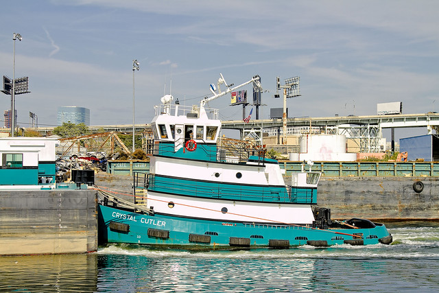
– photo by Mitch Waxman
Built Nov. 04, 2010- this is the tugboat Crystal Cutler and her articulated barge (the Patricia E. Poling) plying the Newtown Creek. The article linked to below will tell you everything you could possibly ask about this tug and those who Captain and command her.
What mysteries they might have witnessed along the Creek, however, are not discussed in this profile.
The 70-foot, 1,500-hp twin-screw tug Crystal Cutler has been pushing and occasionally towing a 15,000-barrel clean oil barge since the tug was introduced in 2010. The tug places a high demand on her captains and crews as she ventures into shallow rivers and estuaries, moving about in a highly dynamic harbor with loads of gasoline, fuel additives or heating oil for small oil terminals.

– photo by Mitch Waxman
Amongst the larger harbor community, Newtown Creek is seldom referred to in glowing terms. There are those who dispute its role and historical significance to the maritime industry- as their eyes and hearts are drawn to the Brooklyn Navy Yard, the West Side of Manhattan, and the gargantuan modern ports in New Jersey.
Many would like to abandon it as an industrial corridor entirely, saying that its day as a working waterway is done, and give it over to kayaking and other recreational occupations.
Founded in 1995, Poling Cutler began operations near the time the former Poling Transportation went out of business.
The Founders of the new company were Ed Poling, whose grandfather started the former Poling company, and Gary Cutler who spent years working in the financial world before getting involved in Marine Transportation.
– photo by Mitch Waxman
One of the greatest sins along the Newtown Creek is precisely how few of its docks are utilized today. Most of the modern business along the Creek looks toward truck transportation to bring their goods to market and for the delivery of raw materials, ignoring their valuable docking rights and imprimature. Miles of bulkheads, expensively installed during prior generations, are allowed to rot away.
What a wasted opportunity.
Moving essential bulk materials by barge is more efficient economically and environmentally. From what we hear, a single barge has the same capacity as 28 – 56 long haul trucks, depending on the industry. Compared to other transportation modes, barge transport of bulk materials is safer in terms of worker injuries and generates far fewer emissions of particulate matter, hydrocarbons, carbon monoxide, CO2 and nitrous oxide on a per ton mile moved basis.
Despite the critical importance of barge transport as a best practice for industries on Newtown Creek, much of the bulkhead along this waterway is in disrepair. Overall bulkhead condition reveals a trend of disinvestment in maritime transit and a decline in related industries. According to Army Corps of Engineers, there were 19 businesses with working docks in 1999, compared to the nine that remain active today, as of January 2011.

– photo by Mitch Waxman
When you boil it down, the whole purpose of the Newtown Creek in its current form is to bring bulk goods into New York City by barge. Admittedly, the days of Standard Oil, Phelps Dodge, and the great Lumber interests are long gone- but… imagine some farmers in upstate New York loading their harvest goods onto a barge, and sending a floating green market directly to Long Island City or Greenpoint or even Maspeth. The barge could return to the farmer laden with cash and whatever else might be needed for the next harvest, completing a virtuous circle.
Imagine standing on the shoulders of giants, rather than rifling through their corpses like so many bugs.
from dot.ny.gov
Commercial and industrial development along Newtown Creek began circa 1854-60 and accelerated rapidly, spurred by low land values, water access for ships and boats, and relative remoteness from populated areas or regulations. The first kerosene refinery in the United States (1854) and modern oil refinery (1867) helped transform Newtown Creek into an industrial waterway. The first few industries also included a distillery near the Newtown side of the Penny Bridge, and the Peter Cooper glue factory relocated from elsewhere in Greenpoint to a site in Bushwick north of Maspeth Avenue10. The influx of industry and jobs, aggressive real estate development in and around Hunter’s Point, including LIRR’s presence on the creek in 1861, and the explosive growth of refined petroleum products all enhanced Newtown Creek’s attractions and helped transform the drainage into an industrial waterway circa 1860-1880. At the Industrial Revolution’s height, Newtown Creek’s industries were flourishing, bringing thousands of people to work at its plants and factories.

– photo by Mitch Waxman
The United States Coast Guard sometimes refers to Newtown Creek as part of “America’s Maritime Superhighway”, a vital industrial waterway which must be protected from the interests of those too short sighted to realize its potential to reinvigorate the economies of those communities through which it flows. It is the very definition of the future, and New York’s destiny is and has always been directly linked to it.
It’s heart warming to see clear eyed mariners like those onboard the Crystal Cutler plying its waters.
from nycppf.org
Significant Maritime and Industrial Area
Newtown Creek, at over 780 acres the city’s largest SMIA, abuts portions of the Greenpoint, Williamsburg, Long Island City, and Maspeth industrial areas. The waterfront area is characterized by heavy industry and municipal facilities, many of which are water- dependent. Newtown Creek is also the largest SMIA in terms of employment.
Although from 1992 to 2008 the SMIA lost roughly half its jobs, from 2000 to 2008 the number of jobs in the SMIA grew by nearly 1,400 to reach a total of approximately 15,000 jobs. Nearly half of the jobs in 2008 were in transportation and warehousing and wholesale trade. However, the business mix is becoming much more diverse. In the eight-year period examined, non-industrial jobs grew by more than 35 percent.


