Archive for the ‘newtown creek’ Category
sprightly cleric
Up Dutch Kills, with a paddle.

– photo by Mitch Waxman
My pal T. Willis Elkins, who’s the Project Manager of Newtown Creek Alliance and the co chair of the Newtown Creek CAG, sent out an invite recently inquiring whether I might have any interest in taking an evening paddle with employees of the NYC DEP on my beloved Newtown Creek – specifically up the Dutch Kills tributary in LIC and a couple of other points of nearby interest in Booklyn.
How could I resist?
T. Willis is also one of the show runners at North Brooklyn Boat Club, found in Greenpoint under the Pulaski Bridge, so that’s where our little crew met up. We donned life vests, listened to Will’s safety speech, and got into canoes. I chose to go out in the smaller of the two boats, presuming that it would be a better spot to take pictures from than the enormous version that everybody else would be in.
The only condition which T. Willis set down for the trip was that everybody would have to row, but… cardio, right?

– photo by Mitch Waxman
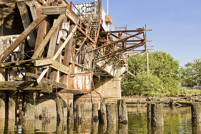
T. Willis had timed our trip to coincide with low tide on the Creek, which is required to pass beneath the MTA’s non functional Cabin M railroad swing bridge which is – at best – just a few feet over the water. We headed into Long Island City along the Dutch Kills tributary of Newtown Creek, and pictured above is the second of the bridges you’ll find along the tributary – Cabin M – which is a truss bridge that can actually open and close.
– photo by Mitch Waxman
The shot above looks east along Cabin M towards the SimsMetal dock. DB Cabin services the Lower Montauk branch of the LIRR’s freight operations, connecting the Wheelspur and Blissville yards. The Long Island Railroad tracks follow the main stem of the waterway eastwards into Blissville, Maspeth and eventually turn north towards Fresh Pond. This traffic is maintained and operated by LIRR’s contracted freight partner, the NY & Atlantic.
Cabin M is part of the now defunct Montauk Cutoff tracks, which provided access to the Sunnyside Yards from the freight tracks along the Creek. The Montauk Cutoff itself was detailed in this post last year.

– photo by Mitch Waxman
We proceeded along Dutch Kills and passed under the venerable Borden Avenue Bridge, one of only two retractile bridges in the City of Greater New York. The sections of Borden Avenue it connects were swamp land until the Army Corps of Engineers blew through in the decade following the Civil War, creating first a “plank road” through the already despoiled wetlands, then a few decades later laying macadam roads and filling in the swamps with landfill. It wasn’t until 1909 that this area kicked into high gear, after the Queensboro Bridge opened. With the construction and creation of the nearby Sunnyside Yards, and the Degnon Terminal industrial zone which surrounds Dutch Kills, this section of LIC soon became known as “America’s Workshop.”

– photo by Mitch Waxman
The head of Dutch Kills sports a “turning basin” built for shipping, which isn’t used in modernity due to that non functioning rail bridge – DB Cabin – found at its intersection with the main stem of Newtown Creek. The turning basin is nearly a mile back into Long Island City, and you can really get a sense of how much new construction is happening in LIC from back here.
There’s also a couple of pretty large combined sewer outfalls – CSO’s – back here, which everybody’s friends at the DEP whom we were paddling with are actually responsible for. The pipes here are connected to the Bowery Bay Sewage Treatment plant in Astoria, for the vulgarly curious.

– photo by Mitch Waxman
I’ve shown you before – lords and ladies – the abandoned fuel barges found back here, which have been allowed to rot away into the water – in previous posts. I’ve also described to you the “situation” which the American Warehouse company has found themselves in during the early 21st century – wherein the undermining of their site by the waters of Dutch Kills have cost them a pretty penny to shore up. Many, many million pennies, I’m told.

– photo by Mitch Waxman
On our way out, we passed under the Hunters Point Avenue Bridge. All of the NYC DOT administered bridges on the Newtown Creek and its tributaries are maintained in working order, and I’ve witnessed this single bascule drawbridge being opened and closed.
Heck, I was a parade Marshall for its centennial, and we even had a parade.

– photo by Mitch Waxman
Our little group visited a couple of other spots nearby, Unnamed Canal and Whale Creek, then rowed out to the Creek’s intersection with the East River for a bit. Along the way, I spotted this feral fellow in Greenpoint.
Upcoming Events and Tours
Wednesday, August 3rd, 6:30 p.m. – 8:30 p.m. –
Glittering Realms Walking Tour,
with NYC H2O. Click here for more details.
Saturday, August 6th, 2:00 p.m. – 4:00 p.m. –
Insalubrious Valley Walking Tour,
with NY Adventure Club. Click here for more details.
Sunday, August 21, 11:00 a.m. – 1:00 p.m. –
Poison Cauldron Walking Tour,
with Atlas Obscura. Click here for more details.
“follow” me on Twitter- @newtownpentacle
bright stone
Tugboat action on part of America’s Maritime Superhighway, Newtown Creek, in today’s post.

– photo by Mitch Waxman
Chickity check yo ass, if you think that new school Newtown Creek is a punk in New York Harbor. Obama and his crew down in D.C. call the Creek a “SMIA” or “Significant Maritime Infrastructure Area.” Dope tugboats can be seen rolling through here all the time.
That’s the Dann Towing company’s Ruby M slipping by and flying its colors.

– photo by Mitch Waxman
Awesome, Ruby M is a 48 year old crusher, bro. She’s a hundred feet long with a beam of 28 feet, and Dann’s Ruby M only needs 12 feet of draft to fire up those 1,750 HP twin steel screws. She was crunching a fuel barge down the Creek, but needed the bitchin’ Pulaski Bridge to pop open before she could thrash through to the east.

– photo by Mitch Waxman
Woe to you, oh earth and sea, if you don’t acknowledge the inherent wonders of Newtown Creek. Above, the latest entrant in the Creek’s pageant of wonders enters the frame as the tug Helen Laraway plies its gelatinous waters. A twin screw, steel hulled push boat, Helen Laraway was built in 1957 and can muster up 2,000 HP to power its twin screws.

– photo by Mitch Waxman
Newtown Creek once hosted the most valuable maritime industrial bulkheads on the entire Earth. The unfortunate truth of the modern age is that only a small percentage of the owners of the waterfront properties hereabouts use their bulkheads. A single barge carries the equivalent cargo of 38 heavy trucks.
Upcoming Events and Tours
Sunday, August 21, 11:00 a.m. – 1:00 p.m. –
Poison Cauldron Walking Tour,
with Atlas Obscura. Click here for more details.
“follow” me on Twitter- @newtownpentacle
nail biting
A bit of Newtown Creek “now and then,” in today’s post.

– photo by Mitch Waxman
One has been at work on several subjects regarding that fabulously decadent cataract of Municpal neglect known to all as the Newtown Creek. It’s kind of big picture stuff, which requires a “long tail” of research on and about certain industries. You can’t understand something modern unless you understand its past, I always say.
For example – If I want to describe the Brooklyn Union Gas Manufactured Gas plant on Newtown Creek in Greenpoint (which is now the National Grid LNG plant on Varick), I need to possess an at least topical amount of knowledge regarding the history and technology of the 19th century Manufactured Gas Industry in New York City.
Actually, that’s not an example, it’s precisely the thing I’ve been working on – to develop an understanding of. Manufactured Gas Plants – or MGP’s as they’re known in the environmental community.
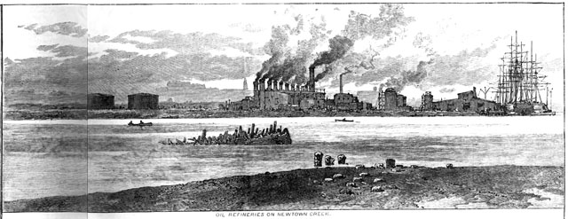
– from Harper’s Weekly, August 6th, 1881 (courtesy google books)
This sort of research always turns up a few surprises, and for an area like Newtown Creek – which is of truly national importance in the story of the second industrial revolution, but for which scant historical visual documentation exists – it’s sometimes pretty interesting. Harper’s Weekly was on quite a tear about my beloved Creek back in the summer of 1881, and presented a few illustrations of “the horror” interspersed with texts describing the oil drenched mud and stinking waters of Newtown Creek.
Here’s my speculation as to what I think we are seeing in these drawings. Educated guesses, btw., that’s all.
Nowadays, the outline of Newtown Creek barely resembles what it looked like back in 1881 – there used to be a couple of islands in the Maspeth Creek/Turning Basin area for instance – but there are few historical constancies with which you can reckon location around the creek when old photos or even illustrations are presented. The LIRR tracks are one of them, and another is the Maspeth Avenue Plank Road.
In the shot above, that pile of piles on the shoreline in the center of the shot? The smokestacks on the far shore? The gas holder tanks on the horizon?

– photo by Mitch Waxman
I think that the illustrator was sitting right about where I was last winter, at the shoreline intersection of industrial Maspeth’s 58th road with Newtown Creek, looking south west towards Greenpoint’s National Grid LNG site with the ruins of the Maspeth Avenue Plank Road directly in front of me.

– from Harper’s Weekly, August 6th, 1881 (courtesy google books)
The view above has railroad tracks in it, ones which follow a certain curve, one that has remained fundamentally the same since the LIRR laid them down in the late 1860’s. The tall smokestacks at the left of the shot are likely those of Phelps Dodge. The ones off in the distance are probably the Haberman rendering plant. Calvary cemetery would be to your left, and I have a sneaking suspicion that the illustrator set up his tripod at Penny Bridge – which is the modern day spot that Review Avenue transmogrifies into Laurel Hill Blvd.
That would put the illustrators point of view somewhere on the eastern side of Blissville, looking eastward towards Maspeth.

photo by Mitch Waxman
I’m of the belief that this is the same shoreline seen in the left side of the shot above, although my photo was captured from out in the middle of the channel while onboard a boat. The masonry on the lower right – or Brooklyn side – of the shot is what’s left of old Penny Bridge, and the 1939 model Penny Bridge (Kosciuszcko) is right where that divot on the shoreline is in the 1881 illustration from Harper’s Weekly. Phelps Dodge would have been found on the east side of the Kosciuszcko Bridge, and their property included the gray building with the blue stripe (the modern day Restaurant Depot).
Upcoming Events and Tours
Saturday, July 16, 11:15 a.m. – 12:45 p.m. –
FREE Newtown Creek Boat Tour,
with Waterfront Alliance (note- WA usually releases tix in batches).
Click here for more details.
Saturday, July 23, 11:00 a.m. – 1:00 p.m. –
Calvary Cemetery Walking tour,
with Brooklyn Brainery. Click here for more details.
Tuesday, July 26, 6:30 p.m. – 8:30 p.m. –
Glittering Realms Walking tour,
with NYC H2O. Click here for more details.
Wednesday, July 27, 1st trip – 4:50 p.m. 2nd trip – 6:50 p.m. –
2 Newtown Creek Boat Tours,
with Open House NY. Click here for more details.
“follow” me on Twitter- @newtownpentacle
abnormal gaps
Cool cars, Bushwick East Williamsburg edition.

– photo by Mitch Waxman
One was happily scuttling along recently, on his way to conduct a tour of the “Insalubrious Valley of the Newtown Creek,” when a charming old rust bucket was encountered on Grand Street not too far from the centuried swing bridge named for it. Unlike other “cool cars,” described at this – your Newtown Pentacle – I’m unable to describe make, model, year, or engine type as frankly – there wasn’t enough left of the thing to do so.

– photo by Mitch Waxman
I can tell you that it was a short bus, and that it still had an engine. It was missing a radiator and all the other parts which would attach around the engine, including the front end’s entire outer body.

– photo by Mitch Waxman
There were four tires on the thing, so that’s something. Additionally, inside the relatively intact passenger cabin, there seemed to be quite a few bits and bobs being stored. Looks like a handyman special to me.

– photo by Mitch Waxman
Just on the other side of the Newtown Creek in Maspeth – where Grand Street transmogrifies into Grand Avenue upon leaving Brooklyn and entering Queens – the short bus’s owner could probably find all the help he or she needs with the project at the MTA’s Grand Avenue depot.
A 600,000 square foot facility that’s four stories tall, the Grand Avenue depot can store 200 city buses at one time just on the first floor. It’s the second floor that would come in handy for the short bus’s owner, as one of the 27 maintenance bays up there would be just the thing to getting this “cool car” up and running again.
Upcoming Events and Tours
Tuesday, July 12, 7:00 p.m. – 10:00 p.m. –
LICHenge, with Atlas Obscura and the
Hunters Point Park Conservancy. Click here for more details.
Saturday, July 16, 11:15 a.m. – 12:45 p.m. –
FREE Newtown Creek Boat Tour,
with Waterfront Alliance (note- WA usually releases tix in batches).
Click here for more details.
Saturday, July 23, 11:00 a.m. – 1:00 p.m. –
Calvary Cemetery Walking tour,
with Brooklyn Brainery. Click here for more details.
Tuesday, July 26, 6:30 p.m. – 8:30 p.m. –
Glittering Realms Walking tour,
with NYC H2O. Click here for more details.
Wednesday, July 27, 1st trip – 4:50 p.m. 2nd trip – 6:50 p.m. –
2 Newtown Creek Boat Tours,
with Open House NY. Click here for more details.
“follow” me on Twitter- @newtownpentacle
rank swamp
Some people just can’t be satisfied with what they’ve got.

– photo by Mitch Waxman
The manifest horror of what’s happened around Queens Plaza and Court Square, real estate development wise, is kind of hard to miss. If you ride the 7 train, or the N/Q lines, I’m sure your jaw routinely drops at the sheer scale of it all. The Citi building megalith – and that impossible, ravenous “thing” which cannot possibly exist in its cupola, whose unblinking three lobed eye gazes greedily down upon the world of men – is nearly occluded by the new construction taking place all around Long Island City.
The real estate industrial complex seems to have won, and Long Island City is no longer the “next big thing.” Instead, it’s a manifest reality. Thing is, the real estate guys aren’t done yet.

– photo by Mitch Waxman
The Paragon Oil building on 49th (or Hunters Point) Avenue, once known as the “Subway Building” and or “Queens Borough Hall” was recently purchased by one of the big developers. Rumors and back channel chats with the “powers that be” in Long Island City have revealed that there is a push underway to rezone the industrial corridors along 49th/Hunters Point and Borden Avenues to a “mixed use” designation which will allow the infiltration and conversion of the M1 or “heavy manufacturing zone” over to residential and commercial (office) use.

– photo by Mitch Waxman
The enormous Blanchard Building on Borden has also been snapped up by the same company that purchased the Paragon Oil building. Official sources indicate that both structures will be purposed as commercial buildings – office space, in other words. The word on the street that I’ve heard is that the rezoning effort would encompass the area found between the Pulaski Bridge and Greenpoint Avenue, and that the eventual end product would resemble what has occurred along Jackson Avenue and the Hunters Point waterfront.
This is, of course, all rumor and scuttlebutt. Can you imagine installing a huge population back here, in the LIC cul de sac formed by Newtown Creek and its Dutch Kills tributary?
Upcoming Events and Tours
Saturday, June 25, 10:30 a.m. – 1:00 p.m. –
The Insalubrious Valley of the Newtown Creek,
with Brooklyn Brainery. Click here for more details.
Sunday, June 26, 11:00 a.m. – 1:00 p.m. –
Calvary Cemetery Walking Tour,
with Atlas Obscura. Click here for more details.
“follow” me on Twitter- @newtownpentacle


