Archive for the ‘Queens’ Category
ethereal character

– photo by Mitch Waxman
The launch we were in had been referred to as the “tin boat” by the Riverkeeper folks, but it was more a smallish rowboat with an outboard engine than anything else. This is the second post of this adventure, click here for the first one.
We had just passed beneath the two rail bridges which vouchsafe and isolate Dutch Kills from the main body of the Newtown Creek, and were heading in the general direction of Queens Plaza when we approached the Borden Avenue Bridge.

– photo by Mitch Waxman
Of course, this century old structure has recently undergone a radical schedule of repairs when it was discovered that one of its abutments had begun to shift, and no small amount of complaint arose at the inconvenience from the legions of truckers and ordinary drivers who mourned its unavailability.
Down on the water however, things were pretty intense, from a purely existential point of view.

– photo by Mitch Waxman
Those bubbles of gas mentioned in yesterday’s post, which were erupting even when the water was unmolested by our passing, delivered a slightly petrochemical smell when they burst. Another member of the Newtown Creek Alliance who was sitting next to me in the boat began muttering “Oh my god” over and over at this point in time.
It wasn’t fear in his eyes, it was disbelief.

– photo by Mitch Waxman
My companion was no virgin or first time visitor to the Creek, of course, in fact his experience of the place is broad and far reaching. When all of your senses get involved with the atmosphere of ruination here, however, one tends to become a bit overwhelmed as your brain attempts to interpret and process the impossible data it is presented with.
The canalized bulkheads of Dutch Kills also tower over you from the water level, creating a sense of forced perspective and inevitability.

– photo by Mitch Waxman
The first thing you see when passing the Borden Avenue Bridge is an archaic sewer outfall, and were the brush not at it’s mid summer height, one would observe the shanty home of the Blue Crow above.
For those of you not familiar with this term, Crow is a name assigned in my little section of Astoria to the myriad metal and refuse collectors known to haunt the neighborhood on “Bulk Pickup Day”. Leave something shiny on the sidewalk, a crow will sweep in and grab it.
Metals are collected and sold by the pound in the scrap and recycling markets of Greenpoint and Long Island City, and these guys make their living from hunting and gathering. I assign them color names based on vehicle, or clothing choices.
There’s also a red crow out there.

– photo by Mitch Waxman
Here is a winter shot from road grade level which shows the sewer and the ever expanding hut of this particular crow. There is a photo of him to be in this Newtown Pentacle posting from February of 2010. Don’t be mistaken, I am not insulting either his industriousness or tenacity, if I were in a similar situation things would go far worse for your humble narrator. This man has been surviving in what has to one of the world’s most extreme environments for years now, and rent free.

– photo by Mitch Waxman
Looking back toward the Borden Avenue Bridge, the ominous humming which echoed along the bulkheads and emanated from above signaled that we had passed under another of the bridges of Dutch Kills. This bridge was built high, and called an expressway by Robert Moses himself.

– photo by Mitch Waxman
Some 106 feet over road grade, the high flying Queens Midtown Expressway leg of the larger Long Island Expressway feeds into the yawning mouth of the Queens Midtown Tunnel less than a mile from here. I call this part of Dutch Kills DULIE, or Down Under the Long Island Expressway.
One of the common complaints heard by eastern bound commuters in the early days of the 20th century was about the horrible smells they encountered when crossing through Long Island City. Moses built his auto bridge as high as engineering and budgetary considerations allowed in response to the plume of industrial outgassing which distinguished a trip through the area in his time.

– photo by Mitch Waxman
Dutch Kills is a particularly important tributary of the Newtown Creek, from an industrial history point of view. What is today a relict of brown fields, industrial spills, and toxic leave behinds was once the economic and manufacturing heartland of New York City. The heavy infrastructure here is no accident, and the waterway was a critical feature that drew one of the great (and largely forgotten) men of Queens to the Waste Meadows at the start of the early 20th century.

– photo by Mitch Waxman
At the end of the 19th century, none of this was here. Sure, there was a muddy road made of creosoted wood blocks and riprap bulkheads called Hunters Point Avenue which ran between isolated industrial sites, and a slightly more modern causeway called Borden Avenue which hosted a few large operations, but this was a swampy and pestilential bog. Brackish creeks wound along knolls of marsh grass and the stubby trees held together mud islands.
The place was lousy with all the junk floating down from Blissville and the sewers in Brooklyn and only Mosquitos and ticks found the place hospitable.
Dutch Kills needed to be fixed.
– photo by Mitch Waxman
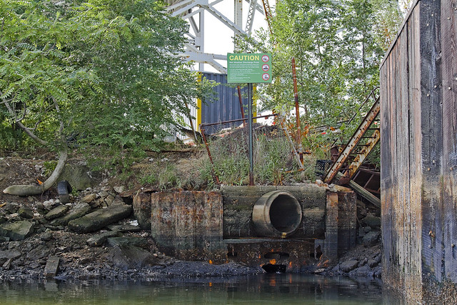
Another sewer outfall is found directly after passing the LIE’s massive footing, which is the sort of improvement that benefited somewhere else rather than Dutch Kills. It was decided by the city fathers in the first years of the 20th century that something had to be done with these swampy wetlands, so close to Manhattan and the gold coast of the Newtown Creek.
Something was needed- a plan with vision, executed by someone who understood the byzantine politics of Tammany Hall and the recently consolidated City of Greater New York. Additionally, it would have to someone with proven “know how” who could “get it done”.

– photo by Mitch Waxman
From the mid 1930’s on, that person would have been Robert Moses. The ultimate political fixer, Moses employed the greatest engineering minds of a generation to shape and design our modern City. While Moses was still in diapers, however, no shortage of great men existed in the City. A plan was presented, and approved, and in both Albany and Washington- strings were pulled by the Tammany men and budgets were approved.
The Army Corps of Engineers were assigned here to canalize, deepen, straighten and erect industrial bulkheads at Dutch Kills in 1914. Land was reclaimed by dumping the fill and spoils produced by the digging of the Belmont Subway Tunnels (leading to to Manhattan) amongst wooden pilings driven deeply into the mud.
The modern shoreline of Queens began to assume it’s current shape.

– photo by Mitch Waxman
It is apparent what happened here, when you see the Hunters Point Avenue Bridge appear before you.
Progress had arrived in Queens, and his name was Michael Degnon.
ponderous and forbidding

– photo by Mitch Waxman
As mentioned in a post the other day, an opportunity arose for me to accompany a representative of Riverkeeper on a survey mission to Newtown Creek recently.
Demanded by the top leadership of the Newtown Creek Alliance itself, this was an expedition whose agenda would require the photographic documentation of bulkheads and shoreline conditions all along the Creek. Of special interest to those involved in the renewal and resuscitation of brownfield sites, the mission as put forward was to get a shot of everything possible. This survey would include observation of the lesser known tributaries of the Creek- Dutch and English Kills, as well as Maspeth Creek, and the East and West Branches which lie beyond the Grand Street Bridge.

– photo by Mitch Waxman
The barriers which guard the secrets of Dutch Kills, which branches from the main body of Newtown Creek just .8 of a mile from it’s locus point with the East River, are two rail bridges. As mentioned in the past, I am no expert on the intricacies of the trackways which snake around the Queens side of the Creek. The expert on this subject was Bernard Ente, who recently passed away, and I wouldn’t offend his memory by pretending to know more than the following:
Neither Bridge (both are moveable) has opened for some time, and it is my understanding that they are part of the “Montauk Cutoff”.

– photo by Mitch Waxman
The survey team was small, as we were in a tiny craft. Hardly more than a rowboat with an outboard motor, three of us sat less than a few inches above the water. There was a mist hanging in the air, as it was early morning, which was quite invisible to the eye but will occasionally become visible in these shots (when I fired off the flash).
Our plan was to take advantage of high and low tides to gain access to the various sections which we were mandated to record, and the low ceiling of the swing bridge at Dutch Kills demanded we make our attempt at ebb tide and exit the tributary before it again flooded.

– photo by Mitch Waxman
I will admit to prayer that a train might pass overhead, for this would be a prize photo for your humble narrator, but alas- no such luck. I don’t know very much about the rails, but I do like taking pictures of trains from odd angles. There was a ghastly sensation afoot in me as well, as I knew that the very air which we were breathing was a hideous miasma of vapor emissions rising from the poison sediments which line the bed of Dutch Kills.
Everywhere, there were tiny bubbles erupting to the surface of the water, and as we disturbed them- mephitic smells swirled about and enveloped the boat.

– photo by Mitch Waxman
Many times have I been down Newtown Creek on the water, but it has always been in nothing smaller than a NY Water Taxi. Additionally, Dutch Kills is “mine”, a branch of the Creek that has received extensive study and historical analysis here at Newtown Pentacle as well as having been thoroughly catalogued photographically. No surprises in store here thought I, English Kills is a bit more “unknown territory” and would likely yield something to hang my hat on.
That is what I thought at the start of this trip.

– photo by Mitch Waxman
To start, the first rail bridge seems to be in a deep state of corrosion, which would make sense given its century long existence. I am no engineer, of course, but this thing hasn’t seen a paint brush in a very long time.
Witnessing the rust and metal fatigue on this bridge actually made me glad that a train wasn’t passing by overhead. The works and motors which power this bridge’s swing action have been burnt out for some time I am told.

– photo by Mitch Waxman
I have never seen it happen (as you would have seen a photo of it here by now) but word is that if the bridge needed to be opened, rail workers would utilize the sort of tow trucks known as “wreckers”, situated at both banks, to winch the thing open.
Sounds bizarre, but the aforementioned Bernard Ente told me that one, and “Bernie was always right” about this sort of thing. Can’t tell you how many crazy stories he would tell me about the history and lore of this place, which my own research would prove him to have been purposely understating.

– photo by Mitch Waxman
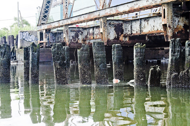
All across Dutch Kills, everything bore that unmistakable colour which typifies the lament and sickness of the Newtown Creek watershed. Iridescent, it is neither black nor white nor any normal color, rather it’s is like something alien coating everything in rotten decay. Metal corrodes, wood molders, stone and cement simply crumble away.
The swampy wetlands which existed here in aboriginal times were known as the Waste Meadows in the 19th century, and perhaps this is still the appropriate terminology for them.
– photo by Mitch Waxman
Pilings and structural elements squamously protrude from the water, whose surface seems thicker than expectation would predict. Normal fluid dynamics apply of course, but the turgid waves behaved in the manner of a broth or syrup as opposed to the more wholesome (but still polluted) water found on the nearby East River.
Additionally, high tide was not marked by invertebrate communities of barnacles or mussels here, but rather by tree ring like deposits of sediment.

– photo by Mitch Waxman
Looking back toward the swing bridge, in the direction of infinite Brooklyn, a long walkway is attached to the pier which the bridge is anchored into.
One thing which I can categorically show in these “bulkhead survey” shots of the Newtown Creek, is that much of the so called land along the Queens bank of the Creek (and large parts of English Kills in Brooklyn) is actually an engineered surface of pilings intermixed with fill and capped with a cement slab- reclaimed land.
One of the scarier ramifications of this, and again– not an engineer- is witnessed in the deleterious condition of these century old wood pilings visible from the water’s edge.

– photo by Mitch Waxman
Next up on this trip is the truss rail bridge, which is built quite a bit higher in elevation than the initial structure and is found at the other side of the pier and walkway which connects to the Swing Bridge. It’s a drawbridge, and the elevated height must have been part of a plan to reduce the need to open the span for water traffic on the once busy Dutch Kills.

– photo by Mitch Waxman
Apologies are offered for vagueness, lords and ladies, as I fear that I’ve spoiled you over the last several years with vulgar displays of “info-porn”. Normally, you’d be reading stats and figures, hearing the name of engineers and learning of long forgotten disasters. Unfortunately, as these two bridges are not publicly accessible, and to study them in any real detail would mean trespassing and demand mandatory jail time… these are the bridge structures which I can describe in the least detail anywhere along Newtown Creek.
Railfans of NYC, anonymous LIRR employees, please leave a comment below and share the wisdom.
As mentioned in the past- I never trespass- like a Vampire your humble narrator needs to be invited inside to do his best work and in the age of terror- no one is invited to look too closely at railroad infrastructure.

– photo by Mitch Waxman
Others, however, are not as constrained as I.
A garish banner caught my eye as we passed beneath the truss bridge. My mind concocted that I was seeing just another windblown tarp or plastic container bag at first, but then as we approached… I realized that it was some kind of painting.

– photo by Mitch Waxman
Hung at a level which allows it to interact with the high tide level, this painting seems to depict- to my eye- a middle eastern city withering in flame beneath the burning thermonuclear eye of god.
What’s more, for once, I can brag to Ms. Heather, over at ny-shitty.com, that I finally got something before she did.
Note: as always, clicking the photo will open a new window at Flickr. Clicking the view all sizes option under the “actions” tab will take you to ever larger incarnations of the shot for closer examination. If anyone knows who the artist is, or what this situation is about, I’d love to hear about it.

– photo by Mitch Waxman
It would seem that someone has set up camp under here, or perhaps it is just a studio space. The undocumented men and women who live in both these “Waste Meadows” -and the Newtown Creek watershed as a whole- are too numerous to count. Many are exactly where they belong, while others are trapped by circumstance and ill omen.
All need to be coaxed away from this place, before the Creek does to them what it has to so many others in Greenpoint and Long Island City.

– photo by Mitch Waxman
No human being should be living in this place, except as part of a penal sentence for an especially heinous offense. Trolls live under bridges, not Americans. Additionally, in the age of terror, how exactly does this go unnoticed by the gendarme?
I cannot stress how often I ask this question as I wander across the Creeklands.

– photo by Mitch Waxman
Despite the fearful atmospherics and forbidding appearance of the water, we pressed on. Our steward from Riverkeeper kept a steady hand on the outboard motor and the tiny boat slid forward across Dutch Kills. This shot is looking back at the two rail bridges of the Montauk Cutoff which we had just passed beneath.
Still no trains.

– photo by Mitch Waxman
Dead ahead was the Borden Avenue Bridge and the high flying Long Island Expressway, the experiencing of which which will be discussed tomorrow at this- your Newtown Pentacle.
blessed are the sleepy…

– photo by Mitch Waxman
As opined in the past, illegal dumping is a bit of an art form here in Queens, and it is not uncommon to find largish domestic items binned out at the entrance to this industrial site or that rail yard. In this case, it’s a rather plush sofa which was left nearby one of the entrances to the Sunnyside Yard, which offered this fellow an opportunity to drop off for a quick nap.

– photo by Mitch Waxman
The ability to sleep in public has always been denied to me, even as a child (much to the chagrin of Mr. and Mrs. Narrator). I marvel at the Asian folks who can catch a quick kip standing up on the R train every day, am jealous of the minute naps which others can surrender to, and can’t imagine leaving myself this vulnerable on the street for even a minute.
Back in the 80’s, if you fell asleep on the subway, someone would steal your shoes.
the dark moor

– photo by Mitch Waxman
Lucid and unwholesome, witness this sky flung perspective of the backbone of New York City- vantaged from several hundred feet above the Newtown Creek and it’s little known tributary- Whale Creek, and high atop the digester eggs of the Newtown Creek Wastewater Treatment Plant.
Gaze in wonder at the majesty of western Queens.
Additionally, click here to see this view reversed, and witness the parallel horizon of infinite Brooklyn.

– photo by Mitch Waxman
That’s the Thomas D. Witte tugboat maneuvering a barge into position at the SimsMetal dock, and the rusty crossing in the background is the non functioning swing bridge which spans the larger Queens side tributary of Newtown Creek called Dutch Kills.

– photo by Mitch Waxman
That’s the LIRR moving along the ancient rail tracks which have blessed the industries and cursed the residents of this area since the early 19th century. The general area that the locomotive track is passing through, employed to this very day by petrochemical interests, is the former Queens location of Standard Oil at Newtown Creek.

– photo by Mitch Waxman
In the distance, from left is Lindenthal’s magnificent Queensboro, the Big Allis power plant, the omnipresent Sapphire megalith, the high flying Long Island Expressway, and a substantial portion of the vast industrial quarters of Long Island City which I call “The Empty Corridor“.
distant ravine

– photo by Mitch Waxman
The final product of my “Grand Walk” which was found on my camera card, which was populated by these puzzling images of centuried statuary lost amongst First Calvary’s emerald devastations.
The figure is life sized, according and conforming to the proportions and stature of the malnourished 19th century. In our modern era of gigantic milk, beef, and grain fed humans, when 6 feet of height is not an uncommon attainment for Italians, Irish, and Chinese alike (all 3 notoriously short statured groups according to historical anecdote), she seems to be a young girl- but this delicate figure conforms to statistical adult height records of 19th century immigrant New York.
We often forget, when discussing fashionable dining trends (locavore or vegan, organic or farm raised- bleh) that the primary goal of our forebears wasn’t ultimately financial acquisition, but was instead a guarantee of basic nutrition.

– photo by Mitch Waxman
Pithy commentary about the fallacies of a modern world, corporatized and commercialized, notwithstanding- attention is called to the plastic baubles which the monument has been adorned with. Such commemorate decoration is commonly observed at area cemeteries, although the rules and bylaws of these institutions publish severe limitations on acceptable grave ornamentation. Unless taste and or propriety are offended, the management seems to allow these minor decorative touches to subsist for a time, after which the activities of groundskeeping and upkeep sweep the place clean.
Behind a fence or near a seldom used entranceway at any of these urban polyandrions, once can easily locate a dumpster containing a polyglot of rotting flowers in cheap vases, joss paper idols, and a cacophony of sentimental or religious trinkets which lie glittering amidst the debris.

– photo by Mitch Waxman
The trinket itself is pedestrian, a childish and injection molded representation of grapes on the vine. What sets me to wonder, and more than wonder, is that undeniable resemblance to the color of the purple bloom worn by the apostate Hibernian and his bizarre companions whose threatening aspect hurled me into a panicked state and meandering escape route through the ancient sections of New York City.
I’ve been queried via private email about this person by several people. Unfortunately, as mentioned in the last posting, I can only remember bits and pieces- but the flower in his lapel matched the color of these plastic beads exactly- of that I can be sure.
What does it mean? I cannot tell you, as it would be madness to attempt the connection of dots between a seemingly random series of events.

– photo by Mitch Waxman
Did your humble narrator, stricken by terror induced delirium, randomly stumble along deeply buried trolley tracks past storefront mystics on Delancey Street and over the Williamsburg Bridge into the heart of 19th century Williamsburg?
It was in the piecing together of these seemingly random shots, in their proper order, that the various historical tidbits began to present themselves, and the journey across the Newtown Creek and through Maspeth led into places which I had never suspected- such as the story of Case’s Crew (the apostate Friends shunned by most, but welcomed here).
Local historical authorities reacted in a bizarre and hostile manner when queried about this group of apostate Friends, I would add. The impression of this exchange puzzled me, but for some, knowledge is meant to be suppressed and zealously hidden away in a vault rather than disseminated freely.

– photo by Mitch Waxman
Often, as I pack up my ridiculous “field kit” and leave the house for one of my “walks” about the vast human hive, I will joke that “I feel like Queens wants me to see something today, probably “that way”- as I gesture in some random direction to Our Lady of the Pentacle or my little dog Zuzu.
Our lady smiles and says “bless”, while Zuzu usually turns around to see what I’m pointing at.
I’ve learned it’s just best to listen to Queens, as it suffers beneath the load it bears for the rest of the City, and simply attempt to understand its terrible story. If some decide to stand in my way, or otherwise obstruct me, they will know what it means to burn away into ignominy and learn the meaning of the words inexorable, irresistible, and merciless.
The story, it’s parable, and the answers to the future offered by this ancient place are too important.

– photo by Mitch Waxman
This “Grand Walk” ended at Greenpoint Avenue, apparently, or at least that’s when the pictures stopped.
The final shot was of the Long Island Expressway from First Calvary, an elevated roadway which hurtles as high as 106 feet above Borden Avenue and that liquid malignity which fills the banks of Dutch Kills. Borden Avenue, of course, is a counterpart to Grand Street in Brooklyn- another ferry to trolley road corridor which has been forgotten and obliterated by modernity.
Ultimately, all roads do indeed seem to lead to Calvary, here in the Newtown Pentacle.
from Documents of the Senate of the State of New York, Volume 5, 18dd, courtesy google books
The road is a double track line laid in the center of Borden avenue, from Vernon to Bradley avenues, and thence a single track along Bradley avenue to Green Point avenue and entrance to Calvary cemetery.
At Vernon avenue a junction is made, and tracks used of the Steinway and Hunter’s Point railroad, along Borden avenue to the Thirty-fourth street ferry slips fronting on East river. A piece of track is laid from Borden avenue along Front street to Third street, a portion of which is used for storing cars, and there is a short side track at the cemetery terminal.
The total length of road now owned and operated from Vernon to Green Point avenues is about one and two-fifths miles, and the portion of the Steinway railroad operated jointly is about one-fifth of a mile, making a total length of road owned, leased and operated by the Long Island City and Calvary Cemetery Railroad Company one and three fifths miles.
Borden avenue is paved with block stone as far south as the drawbridge over the Dutch Kills canal; the remainder of the track is laid upon and along the center of an ordinary earth roadway.
The superstructure is laid with fiat iron street rails where the street is paved, and also along Bradley avenue a distance of onefifth mile.
The general construction of the superstructure is not as permanent in character and condition of maintenance as generally found on surface roads. Ties are widely spaced, and flat rail not thoroughly secured to longitudinal timbers, and the line and surface imperfect. South of the draw-bridge, upon the earth road-bed, the track is laid with light T rails, secured at ends with fish plate, many of which are omitted, causing the ends to form an uneven vertical joint.
From the crossing of the Long Island railroad to Bradley avenue, Borden avenue is a roadway raised up about eight feet above the low flat lands bordering the Dutch Kill and Newton creek, and the portion of the avenue south of the canal is being raised each year, requiring a corresponding raise of superstructure, which may account in part for the imperfect condition of that portion of the tracks; no serious inconvenience can bo experienced, however, as the cars have good, easy springs, and they ride the rail fairly well; yet a thoroughly Constructed, lined and surfaced superstructure would add to the comfort of passengers, and insure greater speed at less outlay of power.
At Calvary cemetery no separate waiting-room is provided, those in hotels being used. At the northerly terminal the covered way and waiting-rooms of the ferry are conveniently near, and afford protection in inclement weather.


