Archive for the ‘Walking Tour’ Category
soothing diagnosis
Want to see something cool?

– photo by Mitch Waxman
There are three public Newtown Creek walking tours coming up, one in Queens and one in Brooklyn and one that walks the currently undefended border of the two boroughs. I have another iron in the fire, which I’ll tell you about later this week. As you’re reading this, I’m likely on a boat with the Working Harbor Committee’s Education program, showing off the harbor to a group of high school students.
Plank Road, with Newtown Creek Alliance, on April 19th. This one is free, click here to get on the list.
Poison Cauldron, with Atlas Obscura, on April 26th. Click here for more info and ticketing.
Modern Corridor, with Brooklyn Brainery, on May 18th. Click here for more info and ticketing.
“follow” me on Twitter- @newtownpentacle
gleaming sands
How the other half lives, in today’s post.

– photo by Mitch Waxman
My pals at Atlas Obscura rang me up and asked if I’d be interested in shooting at one of their events in Brooklyn, and since this offered an opportunity to leave the house (a rare treat during this winter of frozen discontent), I packed up Our Lady of the Pentacle and my camera bag and we set off for Williamsburg. Now, I don’t spend a lot of time around these parts, can’t afford it, but its also nice to see how the other half lives.
from wikipedia
Williamsburg is a neighborhood of 113,000 inhabitants in the New York City borough of Brooklyn, bordering Greenpoint to the north, Bedford–Stuyvesant to the south, Bushwick and Ridgewood, Queens to the east and the East River to the west. The neighborhood is part of Brooklyn Community Board 1. The neighborhood is served by the New York Police Department (NYPD)’s 90th Precinct. In the City Council, the western and southern part of the neighborhood is represented by the 33rd District; and the eastern part of the neighborhood is represented by the 34th District.

– photo by Mitch Waxman
This is the Williamsburgh Savings Bank building at 175 Broadway, a building erected just 10 years after the Civil War. A famous structure, its the domed building you can’t help but notice when exiting the Williamsburg Bridge, at least when you’re on the Brooklyn side.
from wikipedia
The Williamsburgh Savings Bank was an important institution in Brooklyn, New York, from the mid-19th to the mid-20th centuries. A series of bank mergers brought it into the HSBC group late in the 20th century. (It is not to be confused with the nearby Dime Savings Bank of Williamsburgh, now known simply as the DIME, a rival local institution that has remained independent.) It is best remembered for two imposing headquarters buildings still standing, the domed original at 175 Broadway in Williamsburg, Brooklyn, designed by George B. Post, and the later Williamsburgh Savings Bank Tower.

– photo by Mitch Waxman
As transmitted by our hosts, the tale of the WSB includes decades of neglect, wear, and tear. The current owners acquired it just a few years ago (and of course it was controversial, it’s in North Brooklyn, not Queens) and set upon a radical architectural restoration of the bank. Pictured is the meticulous work found on the first of the interior domes.
from nyc-architecture.com
To build a new edifice for the WBS the board of trustees hired George B. Post (1837-1913), a man who had just finished the important Equitable Life Assurance Building (1868-1870), was at present finishing the Western Union Building (1873-1875), and who would later go on to design the icon of money, the market, and capitalism in 1903. Architecturally speaking and with vast hindsight, it was upon the hiring of Post that the WBS secured itself as a structural institution and landmark in Brooklyn. For it is through the tie to its architect that this structurally impressive building gains even more notoriety; George B. Post would later go on to design City College (1886-1906), the Brooklyn Historical Society (1881), the New York Stock Exchange (1903), and other notable buildings throughout the country.

– photo by Mitch Waxman
There were three buildings here, the 1875 original and an early 20th century addition (1906, I think) – both domed – and a 1940’s era office building of pedestrian design. The domed buildings were landmarked, but the office building was not and it was torn down. There are plans to erect a modern hotel on the property, a mammoth 40 story affair. The former bank will act as an event space for the hotel.
for a Landmarks Preservation Committee document generated by municipal authorities back in 1996, click here.

– photo by Mitch Waxman
This is the second dome, which I seem to recall as being of 1906 vintage, but might be misstating the date. The oculus in the center was actually boarded up during the Second World War and remained so until the restoration process began. In case you’re curious, yes, I laid down on the floor in the center of the room and shot straight up.
from ny.curbed.com
When Brooklyn hostel owner Juan Figueroa purchased the Williamsburgh Savings Bank for $4.5 million in 2010, the rumor was that he planned to convert the historic bank building into a hotel. That would have been difficult, though, since the structure is an exterior, interior, and national landmark. The actual plan, it turned out, was to meticulously restore it and turn it into an event space and banquet hall, and place a 40-story hotel right next door.

– photo by Mitch Waxman
The other half lives in Williamsburg, I’m told. The Brooklyn patois pronunciation for this neighborhood is “Willemsboig” and my parents – who used to bank with the company once located here – called it “Da Willemsboig Savins Banks.” They stayed with the company all the way till it became HSBC. That’s brand loyalty, folks. Back tomorrow with a few more shots from within the lush interior, including some details on the vault.
“follow” me on Twitter- @newtownpentacle
Modern Corridor
Want to see something cool? Bring a camera, and follow me.

– photo by Mitch Waxman
When I decided to start doing walking tours of the Newtown Creek watershed a few years ago, I found myself presented with a significant organizational issue. There’s a different story to be told about Maspeth than there is about Greenpoint (also, there are arguably two Greenpoints), yet… the two communities are inextricably linked up. Same thing with Bushwick and Ridgewood, or the residential centers at the Creek’s intersection with the East River. 3.8 miles long by around a mile wide, the Creeklands are vast when on foot. There is also SO much information to pass along, not just about the Creek’s past, but about all the stuff that’s going on right now- EPA, Superfund, the cool things my pals in NCA are doing with Green Infrastructure and Citizen Science…

– photo by Mitch Waxman
My solution was to simply to connect the stories of these places up along the ancient roads or paths along which they grew, and follow the water from one borough to another. “Poison Cauldron” does the Greenpoint to Bushwick route, “Insalubrious Valley” follows a colonial era turnpike path, “Glittering Realms” moves from residential East River Greenpoint back to the industrial zone along another colonial pathway, and “13 Steps around Dutch Kills” traces the Queens tributary back to the Creek and ends at its smaller counterpart Whale Creek in Brooklyn.
The new one- “Modern Corridor”- is all about Hunters Point, one of the least known sections of New York City, which sits directly opposite the Shining City of midtown Manhattan.

– photo by Mitch Waxman
This “Modern Corridor” walking tour starts at the old city center, nearby Jackson Avenue and Court Square, and explores the brave new world rising from the ashes of a 19th century industrial titan- the independent municipality of Long Island City. Writ large, the growing community of the titan real estate development which has reshaped the colonial vintage section of Queens called Hunters Point will be encountered, and one of the finest parks in the entire city visited. This park is built upon a significant piece of rail infrastructure which once allowed train cars to be loaded onto barges for maritime transport to Manhattan and points west.

– photo by Mitch Waxman
Then we walk through to the proverbial wrong side of the tracks, and to the industrial machine surrounding the infamous Newtown Creek. Former home to sugar refineries and cargo docks, rail yards and powerhouses, this will be the future home of thousands who will live in the forthcoming Hunters Point South development which has already begun construction. See it as it is, before the towers rise and the land is reshaped to modern wants and desires.
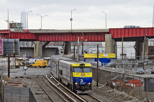
– photo by Mitch Waxman
Skirting along the Creek, you’ll see vast infrastructure, visit DUPBO (Down under the Pulaski Bridge Onramp), and walk over railroad tracks as we head back to the modern incarnation of Long Island City. Bring your cameras, as your friends won’t believe you when you try to describe the places you’ve witnessed. Closed toe shoes are also highly recommended, as is a hat or parasol as there will be little to no shelter from the burning thermonuclear eye of god itself. The walk will be approximately 2 hours in length and will cross all sorts of ground. There will be one flight of stairs involved.
– photo by Mitch Waxman
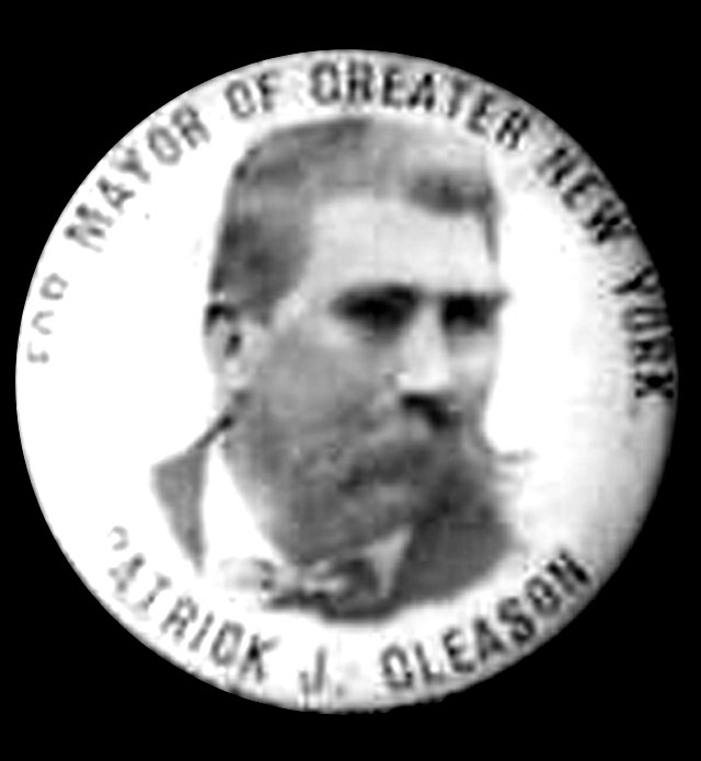
We’ll be passing from the 21st century all the way back to the 1600’s with particular emphasis on the late 19th century, when the fellow pictured above- the notorious Patrick “Battle-Ax” Gleason, served as the last Mayor of Long Island City. Gleason was personally responsible for the construction of the exquisite PS1 schoolhouse pictured in the second shot above, which nearly bankrupted LIC- amongst other imbroglios. Dogged by claims and accusations (and at least one conviction) of corruption- Gleason used to sit in a barber chair outside the Miller Hotel- which is today the LIC Crab House- and hold court with constituent and passerby alike. This was his favorite spot, directly across the street from the LIRR train and ferry terminal. He told those he met to avoid addressing him as “Mayor”, instructing them instead to “Just call me Paddy.”
Hope you can come along, this Saturday at 10- meetup at Court Square Station on Jackson Avenue.
idle curiosity
In today’s post- The New York Marble Cemetery on Manhattan’s Lower East Side.

– photo by Mitch Waxman
If your view of second avenue in Manhattan’s East Village looks like what you see in the shot above, there’s only one place you can possibly be.

– photo by Mitch Waxman
You would be standing on the other side of these gates, found at the end of an alley, and within a walled off corridor which was established in 1831- the same year that the French Foreign Legion first deployed and Charles Darwin left England for the Galapagos onboard the Beagle.

– photo by Mitch Waxman
One of the perks of working with Atlas Obscura is that I can sometimes insert myself into somebody else’s adventure, and in this case, it was Allison Meier’s walking tour excursion to the New York Marble Cemetery at 41 1/2 Second Avenue. She graciously allowed me to attend her sold out tour.

– photo by Mitch Waxman
Check out this page, which I think Allison wrote- at the Atlas Obscura– for the full history of the place (there’s no point in me paraphrasing it). The tombs are all underground, with the grave markers arranged on the walls in the form of stone plaques. The surrounding neighborhood has literally risen around the place, with every building style from 19th century tenement to ultra modern luxury hotel represented around it.

– photo by Mitch Waxman
The president of the cemetery association was there to talk to the attendees, and she described the walls as being quite fragile and in bad condition. Nearly two hundred years of New York air, and vibration, have taken their toll on mortar laid down just ten years before Mary Rogers “the beautiful cigar girl” was found in a trunk floating along on the Hudson- sparking the interest of none other than Edgar Allen Poe.

– photo by Mitch Waxman
Pictured above is the plaque denoting the tomb of Uriah Scribner, father of the eponymous founder of the publishing house “Charles Scribner’s Sons.” Uriah died in 1853.

– photo by Mitch Waxman
1830’s New York City is literally the stuff of legend.
It’s Poe’s town, as well as the NYC that Herman Melville and Washington Irving and William Cullen Bryant knew, a city which had less than a quarter million inhabitants. What we call the lower east side was farmland back then, and the center of town was down near the Battery.
The river fronts were described as a “forest of masts” for all the merchant trading vessels found docked there.
Check out the New York Marble Cemetery here.
“follow” me on Twitter- @newtownpentacle
Want to see something cool? June 2013 Walking Tours-
The Poison Cauldron– Saturday, June 15, 2013
Newtown Creek walking tour with Mitch Waxman and Atlas Obscura, tickets now on sale.
Kill Van Kull– Saturday, June 22, 2013
Staten Island walking tour with Mitch Waxman and Working Harbor Committee, tickets now on sale.
The Insalubrious Valley– Saturday, June 29, 2013
Newtown Creek walking tour with Mitch Waxman and Newtown Creek Alliance, tickets now on sale.
possible variations
“follow” me on Twitter at @newtownpentacle
Upcoming Walking Tour- the Parks and Petroleum tour- May 12, next Sunday

– photo by Mitch Waxman
Meetup at the corner of Kingsland and Norman Avenues in Greenpoint.
We will be exploring the petroleum and waste transfer districts of the Newtown Creek watershed in North Brooklyn. Heavily industrialized, the area we will be walking through is the heart of the Greenpoint Oil Spill and home to scores of waste transfer stations and other heavy industries. We will be heading for the thrice damned Kosciuszko Bridge, which is scheduled for a demolition and replacement project which will be starting this year.
Photographers, in particular, will find this an interesting walk through of a little known and quite obscure section of New York City.
Be prepared: We’ll be encountering broken pavement, sometimes heavy truck traffic, and experiencing a virtual urban desert as we move through the concrete devastations of North Brooklyn. Dress and pack appropriately for hiking, closed toe shoes are highly recommended- as are a hat or parasol to shield you from the sun.
Bathroom opportunities will be found only at the start of the walk, which will be around three hours long and cover approximately three miles of ground.
Drivers, it would be wise to leave your cars in the vicinity of McGolrick Park in Greenpoint.
Click here for tickets to the Newtown Creek Alliance Parks and Petroleum walking tour with Mitch Waxman,
Sunday, May 12, 2013 at 11 am.

– photo by Mitch Waxman
Down Under the Kosciuszko Bridge Onramp, or DUKBO, is the name I’ve assigned to this lunar landscape of industrial mills and waste transfer stations which lines the Brooklyn side of the Creek. This year is functionally the last time you will be able to witness this place, as the Kosciuszko Bridge replacement project will be kicking into high gear in the fall of 2013.
For the urban explorer and photographer crowd, this is a wonderland of shattered streets and rusted infrastructure which will soon be eradicated from all but living memory.
Tickets are available, should you care to witness the place prior to its forthcoming demolition.

– photo by Mitch Waxman
The tour will tell the story of Standard Oil at its start and cross over the Greenpoint Oil Spill’s heart, revealing that lost world of industrial aspiration and 20th century dissolution which lies less than a mile from the geographic and population centers of New York City.
In the past, I’ve described the area as “Mordor” at this, your Newtown Pentacle, and the Tolkien analogy is apt. The very air you breathe is a poisonous fume, the water is hopelessly tainted with bizarre combinations and millions of gallons of petroleum and industrial chemicals, the soil is impregnated with heavy metals, asbestos, and truly- who can guess all there is that might be buried down there?
An odd concentration of food distribution, waste transfer and garbage handling facilities, and energy industry plants make the area remarkable, and everywhere you look will be a “colour“- a bizarrely iridescent sheen which resembles no wholesome nor familiar earthly color but is instead like something from out of space- coating every bit of broken masonry and the sweat slicked skin of laborer and passerby alike.

– photo by Mitch Waxman
Other upcoming tours:
The Insalubrious Valley– Saturday, May 25, 2013
Newtown Creek walking tour with Mitch Waxman and Atlas Obscura, tickets now on sale.
Hidden Harbor: Newtown Creek tour with Mitch Waxman – Sunday, May 26,2013
Boat tour presented by the Working Harbor Committee,
Limited seating available, order advance tickets now. Group rates available.
for a full listing and schedule of tours and events, click here


