lamenting bitterly
More 7 train shenanigans.
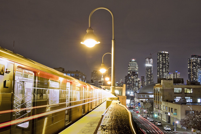
– photo by Mitch Waxman
For the shot above, it took three attempts to get what I was looking for. I had to time the exposure so that I clicked the shutter roughly ten seconds before the 7 left the station, which gave me the open doors and some detail on the exterior of the train set. The twenty seconds that followed saw the doors close and the 7 leaving the station, hence the streaks of light from its running lights.
This shot was of the sort I had in mind when I set out from HQ in Astoria, on my “not too much walking” photo walk. That busted toe is still a factor.

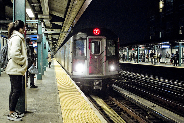
– photo by Mitch Waxman
I rode the 7 into the City, and debarked at the Grand Central stop. This platform can be referred to as “Grand Central Station” as it’s not the final stop for the subways rolling through it. The grand old building it sits under is Grand Central Terminal, indicating it as the destination for the rolling stock used by Metro North. The 7 has two terminal stops, one in Flushing out in Queens, and the other at Hudson Yards on Manhattan’s west side. I’m not nerdy about trains, but specificity is important when discussing any subject in an intelligent manner.
“Revenue service,” as in carrying paying customers, began in this station on the 22nd of June in 1915. Back then, the 7 was a short run, transiting between LIC’s Vernon Jackson and Grand Central. It wasn’t until November of 1916 that the trains began going to Queensboro Plaza, and the Flushing Line extension (to Alburtis Avenue) didn’t open until April of 1917. Times Square was reached in 1927, and 1928 is when the 7 reached Flushing. 2015 is when the Hudson Yards stop opened.

– photo by Mitch Waxman
Upon arriving on the streets of Manhattan, a humble narrator hit the streets and changed the camera’s setup over to a proper tripod and a better lens configuration. My plan for the night was to try and keep both the Chrysler Building and Grand Central Terminal in frame and never stray too far from “Da Deuce,” or 42nd street for those of you not from “here.”
The broken toe thing, and I’ve got at least another month of healing ahead of me, means that one has to keep the scuttling to a minimum and really work the hell out of a spot when I’ve arrived at it. I can hear industrial Maspeth calling, but I dare not answer for a few weeks. In the meantime, the Shining City is sitting there like some kind of cheap whore, just waiting to be exploited.
“follow” me on Twitter- @newtownpentacle
Come on a tour!
With Atlas Obscura – Infrastructure Creek! My favorite walking tour to conduct, and in a group limited to just twelve people! December 14th, 1:30-3:30 p.m.
Click here for more information and tickets!
Buy a book!
“In the Shadows at Newtown Creek,” an 88 page softcover 8.5×11 magazine format photo book by Mitch Waxman, is now on sale at blurb.com for $30.
wholly allied
A Jedi craves not these things…
– photo by Mitch Waxman
My hermitage and recovery period for the broken toe has been, frankly, driving me nuts with boredom. Given the diminished capacity one is experiencing on the walking around front, a humble narrator evolved a plan which would involve a fairly minor amount of scuttling about while also putting the camera in front of picturesque locales. A quick limp over to my local subway stop ensued, whereupon a transfer to the IRT Flushing or 7 Line subway line was accomplished in Jackson Heights – pictured above.
A long standing assertion of mine is that the 7, of all NYC’s subway lines, offers the most interesting and picturesque set of views to be found in the entire system (Ok, I’ll admit that Broadway Junction over in Brooklyn is pretty amazing as well).
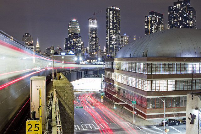
– photo by Mitch Waxman
Given that I have been a caged animal and literal cripple of late, I haven’t been able to shoot anything intentional in awhile. What I’ve been offering for the last few weeks here at Newtown Pentacle has either been shots from the archives or “catch as catch can” snapshots gathered when I absolutely positively had no choice about being “out there” despite the broken toe and badly swollen left foot. Last week, I finally got to think out a route – and plan in advance – a few shots I was desirous of capturing.
The one above represents around a thirty second exposure from the 40th/Lowery stop, looking down on the northern side of Queens Blvd. from the elevated station. I was using that ultrapod gizmo I’ve been rattling on about, which is small enough to allow me to skate around MTA’s rules about using a tripod on their properties without a permit. Saying that, I did have the photo bag kit and kaboodle with me, gear which was used at other locations with less restrictive rules.
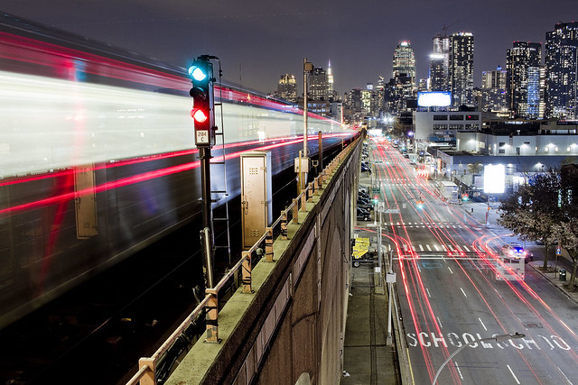
– photo by Mitch Waxman
The shot directly above is from the 33rd/Rawson stop on the 7, looking again towards the northern side of Queens Blvd., and that factory building with the inflatable tennis dome on it is the former Swingline Staplers factory. One of the things I find interesting about the long exposure stuff is the way that traffic patterns get visualized by the long streaks of brake light as automobiles shoot through the frame. When you talk to transportation advocates or the city planner types, they always spout about “should be’s” and “design intents.” I usually offer them unwanted feedback about “desire paths” and “the best laid plans of mice and men.”
Whatever these characters want people to do on these roads, pictured above is a graphic representation of what actually happens.
“follow” me on Twitter- @newtownpentacle
Come on a tour!
With Atlas Obscura – Infrastructure Creek! My favorite walking tour to conduct, and in a group limited to just twelve people! December 14th, 1:30-3:30 p.m.
Click here for more information and tickets!
Buy a book!
“In the Shadows at Newtown Creek,” an 88 page softcover 8.5×11 magazine format photo book by Mitch Waxman, is now on sale at blurb.com for $30.
servile purposes
Fishies!

– photo by Mitch Waxman
Just a single shot today, from a few years ago, of the offerings on display in a Cretan fish market over in the nation of Hellas. I finally managed to get some work done behind the camera last night, and look forward to showing it to you all next week.
“follow” me on Twitter- @newtownpentacle
Buy a book!
Limited Time 25% off sale – use code “gifts25” at checkout.
“In the Shadows at Newtown Creek,” an 88 page softcover 8.5×11 magazine format photo book by Mitch Waxman, is now on sale at blurb.com for $30.
thing depicted
Happy Birthday Verrazzano-Narrows Bridge!

– photo by Mitch Waxman
One will not assert that the Verrazzano is in fact a giant cage designed to contain a Lenape earth monster submerged in NY Harbor. Instead, the focus is on the engineering achievements of Othmar Amman and the organizational prowess of Robert Moses – the two fellas who are primarily responsible for the Verrazzano opening on November 21, 1964.

– photo by Mitch Waxman
A humble narrator will avoid rattling on about how in just five years Moses’ crews of more than 12,000 laborers constructed the thing, nor about its various statistics and cyclopean size. One will mention that the 228 feet of clearance over high water offered by the Verrazzano Narrows Bridge is the governing height used by maritime engineers for how high to build all sorts of shipping. Sooner or later, every ship on the planet will theoretically enter NY Harbor, and the Verrazzano is the gatekeeper.

– photo by Mitch Waxman
The only mistake in this fairly sublime structure’s design was the omission of a mass transit trackway between Brooklyn and Staten Island, in my opinion. The upper deck opened on this day in 1964, but the lower roadway was still under construction and wouldn’t be available for use until June 28 of 1969.

– photo by Mitch Waxman
My pal Kevin Walsh of Forgotten-NY, whose childhood in Brooklyn’s Bay Ridge section was framed by construction of the Verrazzano, gave a talk last night at the Bay Ridge Historical Society about the span. I wasn’t able to attend, but I’ve also been privileged to receive his remembrances about the thing in person.

– photo by Mitch Waxman
It seems that the towers of the Verrazzano are fairly infested with nesting Peregrine Falcons, so it can rightfully be referred to as an aerie. Down below, on the water, it’s a maritime superhighway, as the Ambrose Channel leads commercial shipping into NY Harbor towards Port Elizabeth Newark under the bridge. Suffice to say that a significant number of sensors and scanners are secreted and secured to the span, searching for various security threats which might be carried in to the inner harbor on these ships.
Friends in the maritime industrial world have opined, regarding these devices and technologies which they can’t talk about, that “it’s like Star Trek.”

– photo by Mitch Waxman
Today marks 55 years for the Verrazzano. As far as the “mythological” senses shattering behemoth that the Lenape whispered of as being “the grandfather of turtles,” which the Verrazzano’s great weight keeps locked in a primeval prison, the less said the better.
There are also things dwelling in the waters on the… Staten Island… side of the narrows which we must not ever talk about, lest they arise.
“follow” me on Twitter- @newtownpentacle
Buy a book!
Limited Time 25% off sale – use code “gifts25” at checkout.
“In the Shadows at Newtown Creek,” an 88 page softcover 8.5×11 magazine format photo book by Mitch Waxman, is now on sale at blurb.com for $30.
exhausted whining
Not so minimalist Wednesday.

– photo by Mitch Waxman
Luckily, one had a couple of “have to’s” this week which forced me to limp out of the house and along the way shoot some photos. Monday night, in particular, was interesting visually due to the steady rain. I will stand behind and defend the assertion that NYC never looks as good as it does when it’s raining.
Pictured above is the IRT Flushing line entering the Court Square station during a precipitant interval.

– photo by Mitch Waxman
Back in Astoria, a humble narrator was waiting for Our Lady of the a Pentacle to emerge from within a bodega with the loaf of bread and quart of milk she ventured within to attain. My thoughts were centered around my beloved Newtown Creek, and the torrent of sewage which was undoubtedly pouring into it during the rainstorm.
When I long for the Creek, I stare at sewer grates, which make me feel connected to it.
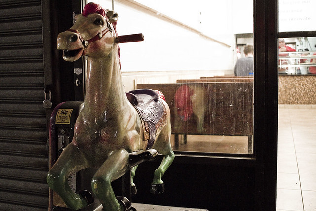
– photo by Mitch Waxman
Last night it wasn’t raining, but I did manage to garner a bit of exercise walking to and from the Community Board meeting on the other side of the neighborhood. I hate the fact that this is the longest walk I’ve willingly undertaken in the last three weeks. I also hate how long it took, due to the pace I now walk at, and how many shots of mundane things like this child’s ride in front of pizza joint on Steinway Street I gathered.
Death. Annihilation. Hatred.
“follow” me on Twitter- @newtownpentacle
Buy a book!
Limited Time 25% off sale – use code “gifts25” at checkout.
“In the Shadows at Newtown Creek,” an 88 page softcover 8.5×11 magazine format photo book by Mitch Waxman, is now on sale at blurb.com for $30.


