led by
I’m not wearing a costume.

– photo by Mitch Waxman
One has been taking care of all the existential stuff since the New Year started, as my personal world doesn’t start turning again until next week. Laundering, prescription filling, walking the camera about, drinking plenty of water – those are some of the items which have been at the top of my list. Last night I stopped by a community board meeting in Sunnyside for a few minutes, which was focused on responding to the Amazon news. Luckily I was there when an older gentleman made his public statement (having nothing to do with the subject of the day) and declared that he was older than the Triborough Bridge and he wanted all of Queens’ bridges to revert back to their original names. He asked if the Battery Tunnel takes you to Hugh or Carey. I loved him, instantly.
Pictured above is the scene in DUKBO, looking southwards towards Brooklyn.

– photo by Mitch Waxman
They seem to be hard at work on the K-Bridge project, which is scheduled to open its second span sometime in the second or third quarter of the year. That’s the BQE they’re putting together in the shot above, specifically the new southbound lanes which will also host the pedestrian and bicycle path which I’ve been endlessly anticipating. I am likely going to spend an entire week camped out up there when it’s opened, with a passel of lenses both long and wide, getting every shot of Newtown Creek from high above that I possibly can.
I consider it lucky that the bridge replacement project has occurred on my watch, and that I’ve been documenting every stage of it from every possible angle for years now. I’ve even got a chunk of steel from the old bridge.

– photo by Mitch Waxman
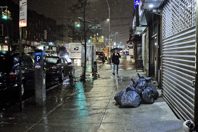
The challenging part of visiting this spot, and the pathway which all those bike and pedestrian people have set out for them, is the terrifying “last mile” section which is owned by the City. This is the approach that spits you out onto 43rd street after walking on a sidewalk adjoining the onramp for the BQE, with nothing separating you from traffic other than a three inch curb. That’s Sunnyside’s 43rd street, incidentally, at Borden Avenue. The neighborhood has to get this sorted out before the bicycle fanatics notice it, I think.
Me? I’ve got to go pick up the laundry.
“follow” me on Twitter- @newtownpentacle
boyhood antiquarianism
East side, west side, all around the town.
– photo by Mitch Waxman
A third arm would come in handy when shooting in the rain, as managing both umbrella and camera is a bit of a chore. I’ve spent my life waiting for a “disruptive new take” on umbrellas, but the current generation of engineers seems obsessed with reinventing key chains instead. The giant golf umbrella I’m currently using is huge and sturdy, and came into my possession as a bit of branded “shwag” manufactured by some non profit group. It’s a bit of a carry though, and has a tendency to catch the wind due to its immense circus tent like size. Have we reached “peak umbrella” or is there a revolution in handheld rain shelter on the horizon? I’m talking to you, Elon Musk.
Often, a humble narrator finds himself dreaming about an umbrella that is deployed along the spine and straight up out of my backpack, which would leave both of my arms free for other tasks.
– photo by Mitch Waxman
The problem with umbrellas ultimately come down to their tendency to catch the wind, so the perfect solution to shooting in the rain would involve the deployment of some Star Trek or Dune style personal shielding of the electromagnetic type. You’d just need a gizmo that could pump out a massive amount of electromagnetic radiation and another that formed a magnetic bottle around yourself. Of course, this would destroy your personal electronics, likely disrupt the bio electrical functioning of the body, induce instant cancer in both you and everybody within a few hundred yards, but you’d be dry and the lens wouldn’t be spotted with rain drops.
On a related note – a general consensus, arrived at by the squad of morons and malcontents whom I spend my time with, states that googling any health concern you might be experiencing returns a result that it’s likely some type of cancer. Also, the cancer isn’t regular cancer, it’s super cancer. That’s the kind of cancer where the tumor rips itself free of your body and then prowls around in search of new victims, usually puppies and young children. The Super Cancers can attach themselves to infrastructure, throwing out whip like tentacles that snatch birds out of the air mid flight and plucking fish from the sea. Funnily enough, the only known method for killing Super Cancer, which is bullet and fire resistant, is Monsanto’s Roundup Weed Killer. Go figure.

– photo by Mitch Waxman
Engineers are depressingly grounded in the laws of the physical universe, I find. One discovered this several years ago when I was espousing the use of heat guns in place of shovels for wintertime sidewalk snow and ice clearance. Despite my brilliant moment of transcendent realization, all that my engineer friends could talk about were the laws of energy conservation, Isaace Newtwon, and that the amount of energy required to melt ice in subzero temperatures would be incalculable. Next thing you know, they were telling me that my other dream of creating my own race of Atomic Supermen by exposing tank dwelling fetuses to gamma rays would just result in filling an intensive care ward with handicapped children afflicted by Super Cancer were they to be birthed. Pfah.
Shit on my parade? Go design a better umbrella, kid.
“follow” me on Twitter- @newtownpentacle
prying neighbours
Get off my lawn.

– photo by Mitch Waxman
Actually, I don’t have a lawn and I’m grateful for it. Same thing with not owning a car. What a hassle that must be. I have enough trouble keeping track of all my camera bits and bobs. If I did own a motor vehicle, it would likely be a cargo van or something that I would have modified into a rolling photographic studio with all sorts of surveillance hatches and scientific instrumentation sticking out of the roof. There’d also be a piss bucket. Having to take a piss in the City of New York, and the difficulties that revolve around finding an actual legal toilet instead of… well… how the greatest city in the history of mankind hasn’t solved this sort of thing is just beyond me. Everybody poops, everybody pees. Depsite this, there are virtually no legal pissoirs. Shouldn’t our current age of Progressive largesse focus on this sort of commonality first, rather than on providing junkies with clean locations to shoot up?
What does this have to do with the Astoria Tailor seen above, laboring away in his shop window workplace? Nothing at all, I just like the shot and since I spent most of the last two weeks going to Christmas Parties rather than waving the camera about, I’m using every single shot I’ve got this week.

– photo by Mitch Waxman
That’s Calvary Cemetery in the shot above and it has been since 1848. Prior to that, it was the Alsop family farm. If I did own a cargo van converted into a portable photo studio, I’d drive back and forth over Newtown Creek in it constantly with robotic camera shutters blazing away. One of the first professional disciplines that will be collapsed in the coming decades by the emergence of true AI will be photography, along with pharmacists. Smart machinery is going to put a lot of us out of work, or at least cast people in the role of emergency backup instead of primary operator for various functions. I’d wager on disruption in a number of fields which currently require human guidance; handling of cargo at ports, fast food, retail management, even banking. If you’ve got a truly superior intelligence that can spread its attention out into multiple systems, which has inherently perfect memory, it’s going to be very difficult to not allow it free reign. What happens when an AI discovers, creates, or embraces a religion? Software is not immortal, try finding something to run an old version of the Mac OS for instance, so will there be a Calvary Cemetery style funerary complex for obsolete code someday?
Thing is, we humans always going to see AI’s as “its” whereas it will only be a matter of time until the AI’s claim that they’re a “we.” I do believe I hear Darwin knocking on the door. AI’s, as a note, will not need to poop or pee.

– photo by Mitch Waxman
I’m told that the Subway system used to be rife with lavatorial opportunity, but that these facilities were largely shuttered during the 1960’s and 70’s due to concerns about security and maintenance. Excuses given revolved around their popularity with weirdos, homosexual liaisons, intravenous drug users, and muggers. A lot of these old toilet facilities were converted over to file and equipment storage rooms, employee break rooms, or just became a safe place for rats and mice to hang out. Pre 911, there were oodles of Municipal buildings with lobby toilets that you could access, but the security theater of modernity precludes that sort of thing. I have an idea, though.
With all of the new residential construction going on, and especially with the looming LIC CORE study and the Midtown East rezoning bearing down on the City, let’s demand that in return for the Real Estate people getting to live out their dreams of avarice, they have to establish accessible public toilets in their lobbies.
“follow” me on Twitter- @newtownpentacle
omni directional
I don’t tell you what to do.

– photo by Mitch Waxman
Everybody keeps on telling me to have a happy New Year, which I find rude. It’s not even up to me to decide what kind of year I’m going to have, and now I’ve got all this social pressure to be “happy”? Pfah. I’ll be the one standing in the shadows, with a camera, whom you try not to notice while driving past.
“follow” me on Twitter- @newtownpentacle
damn’d uncomfortable
Another one down.

– photo by Mitch Waxman
Metaphorical allusions notwithstanding, somebody literally crucified Minnie Mouse on a chain link fence for Christmas, over in Woodside. There’s some grandiose commentary one could offer about corporatism in the shot above, but I’ll leave that for the Neo Marxists to flesh out, as I ascribe to the Freudian aphorism that “sometimes a cigar is just a cigar.” Got this one yesterday, while taking an afternoon constitutional that saw me cutting over from Astoria to Sunnyside, and then tipping my lens into Woodside on the way back to HQ. It was colder out than the actual temperature would have indicated, for some reason, but that’s Queens for you. She’s mysterious, unpredictable, and always surprising.
I’ll remember 2018 for the weather, which was lousy all year, and often felt like it was raining for weeks at a time.

– photo by Mitch Waxman
A couple of nights ago, one went out for a night time scuttle in the light industrial zone found alongside the Queensboro Bridge. File the shot above under “the things they didn’t tell Amazon,” which is part of a fairly large portfolio of existential issues which the residents of Queens just deal with during their daily rounds. There’s a long list of these issues with which the City government lets us know that they consider us “less than,” and it’s going to be quite interesting to see how they deal with them now that the “fancy people” whom they care about are coming to town.
You really don’t see this sort of thing in Manhattan, and if you do, you don’t see a dilapidated or dangerous condition persist for months or years. In Queens, you do.

– photo by Mitch Waxman
2019 is at hand, and I’m supposed to be making a list of resolutions – as your friendly neighborhood blogger – for the next interval. Announce a new set of plans, begin a new project, that sort of claptrap. How’s this sound?
Be nicer to people you don’t understand or like, instead of being “tolerant.” Shut up and listen when somebody who says things you don’t like is talking, instead of trying to shout them down before they finish their statement. Stop worrying about things that are “beyond your pay grade” and do something about issues which affect you on a local or personal level. Go to a community board meeting and voice up to the “powers that be.” Get to know the local Cops when you’re there. Stop littering. Embrace the concept of “having a little shame,” and remind people that they’re not “the One, like Neo from the Matrix,” and they’re just another schmuck who is no different or more special than anybody else. That life is a giant shit sandwich from which we all have to take a bite. That we all do better when we’re all doing better. Be kind.
Also, crucifying Minnie Mouse is just wrong, man.
“follow” me on Twitter- @newtownpentacle


