smartly curled
A visit to Manhattan, in today’s post.

– photo by Mitch Waxman
For reasons that I’d rather not go into, one had several hours to kill recently while immersed in an elevated and overtly emotional state of mind. Wandering around First Avenue and its side streets, between 14th and 23rd street, happenstance carried me to 415 14th street where one may notice that the Church of the Immaculate Conception stands. The address once belonged to a Presbyrterian outfit that called itself “Grace Chapel” but after the construction of Stuyvesant Town and Peter Cooper Village annihilated the Roman Catholic original “Immaculate Conception” across the street, the Catholics purchased the building and moved in. They’ve been here since 1946, I’m told.
from immaculateconception-nyc.org
In 1914, the Metropolitan Life Insurance Company embarked on one of the most successful urban renewal projects in the history of New York City. It created Peter Cooper Village and Stuyvesant Town to address a projected housing shortage among returning World War II veterans. The Met, as it was known in those days, bought up block after block of the area between 14th and 23rd Streets, from First Avenue to Avenue C. Included in the purchases were Immaculate Conception Church, its rectory, convent and school buildings.
The Archdiocese of New York then purchased an Episcopal mission settlement, Grace Chapel, on the south side of 14th Street, East of First Avenue. It was renamed “Immaculate Conception.”

– photo by Mitch Waxman
The Lower East Side, along with Harlem, barely resembles the neighborhood I remember from the 1980’s. This particular corner used to be a good place to die, or at least catch a scorching case of death, and there was a bit of a fortress mentality to the area back “in the day.” Junkies, addicts, and the whole crew of loathsome indigents who called the L line Subway station on 14th “HQ” used to pollute the sidewalks hereabouts. It was odd to see the gates to the church open, and a sign promised that there was a cloister back here, so I scuttled onto the property to take a look.
from wikipedia
A cloister (from Latin claustrum, “enclosure”) is an open space surrounded by covered walks or open galleries, with open arcades on the inner side, running along the walls of buildings and forming a quadrangle or garth. The attachment of a cloister to a cathedral or church, commonly against a warm southern flank, usually indicates that it is (or once was) part of a monastic foundation, “forming a continuous and solid architectural barrier… that effectively separates the world of the monks from that of the serfs and workmen, whose lives and works went on outside and around the cloister.”

– photo by Mitch Waxman
Unfortunately, the so called cloister seems to have converted over to a parking lot, so there wasn’t too much to see. There’s also a parochial school back here, and for some reason – unaccompanied middle aged men with cameras seem to set off alarm bells when the subject of school children comes up so I headed back out to 14th street. I did stop into the chapel, but there were bunches of adherents praying in there and I didn’t want to disturb their reverie or violate their privacy by taking photos.
It’s quite lovely in there, however.
from wikipedia
Stranger danger is the danger to children presented by strangers. The phrase stranger danger is intended to sum up the danger associated with adults whom children do not know. The phrase has found widespread usage and many children will hear it (or similar advice) during their childhood lives. Many books, films and public service announcements have been devoted to helping children remember this advice. The concept has been criticized for ignoring the fact that most child abductions and harm result not from strangers, but rather from someone the child knows.

– photo by Mitch Waxman
On the front of the church, there’s a public fountain. There aren’t many of these 19th century artifacts left in Manhattan – I can think of one in the west village and a couple down near the City Hall/Canal Street area that was once known as the Five Points, but it’s a rare thing to spot them anymore. I’m far more surprised that it survived the urban renewal period of the 40’s and 50’s than our current era of gentrification, actually. It’s more than likely that there used to be a common cup chained to the fountain, not unlike the one displayed in a period photo at ephemeralnewyork in the link below.
from ephemeralnewyork
This 1913 photo shows a boy at a public water fountain in Madison Square Park; he’s drinking from a common cup attached to a chain. Of course, no one today would ever drink from the same cup thousands of strangers also put their lips on. But back then, in pre-germ-awareness times, not everyone realized how unsanitary it was.

– photo by Mitch Waxman
I’m no metallurgist, but to me the fountain seems to be bronze. There’s a basin and two ornamental fishes, the latter were where the water was dispensed into the former. If you think its difficult finding a place to sit down or use a toilet in 21st century Manhattan, you couldn’t imagine how rough it would have been back in the late 19th century.
Back then, this part of the Shining City was a thriving immigrant neighborhood of tenements and small factories that extended to the East River. The other side of the street, where Stuyvesant Town currently squats, was once a slum called “The Gaslight district.” Amenities like this drinking fountain were acts of charity offered to the affected masses by the well off. On the masonry above it is the legend “Ho, everyone that thirsteth.”
from wikipedia
In 1842, one gas storage tank at East 23rd Street and the river was erected, quickly followed by the construction of other gas tanks, and by the late 19th century, the site of the complex had become known as the Gashouse District because of the many tanks that dominated the streetscapes. The tanks, which sometimes leaked, made the area undesirable, as did the Gas House Gang and other predators who operated in the area. With the construction of the FDR Drive, the area began to improve. By the 1930s, all but four tanks were gone and, while shabby, the area was no more blighted than many parts of the city after the years of the Great Depression; crime in the district had been endemic, however. When Alexander S. Williams was promoted to police captain and assigned to the area, he met the gangs’ violence with equal force of his own, putting together a brute squad that beat up gangsters with clubs. He commented: “There is more law at the end of a policeman’s nightstick than in a decision of the Supreme Court.

– photo by Mitch Waxman
At the base of the bronze fountain is a legend offering the birth and death dates for a person named “Fanny Garretson Russell.” I looked around the web for information on this inscription, which you’d think would be well documented due to its presence in Manhattan, but found nothing.
“OK” thought I, and utilizing some of my “find the hidden history of Queens” skills, I got to work-
Fanny was the grand daughter of Charles Handy Russell, of Providence Rhode Island. Russell’s father was a Major in the continental army during the American Revolution, and the family history goes all the way back to the Mayflower on one side and the founding of Woburn, Massachusetts in 1640 on the other.
Charles Handy Russell came to New York in the 1820’s, rising to a position of financial and political prominence. Russell was a railroad man, the President of the Bank of Commerce, dabbled in maritime insurance, was part of the original board of directors in charge of Central Park, and a husband to Caroline Howland. The couple had children: Charles Howland Russell – who was the Private Secretary of the United States Secretary of State during the administration of President Hayes, and Samuel Howland Russell were amongst them.
Samuel, a mining engineer who graduated from Columbia University, married Elizabeth Watts Garretson in June of 1884. Their first daughter was named Fanny, who died on the 23rd of August in 1894. This fountain’s dedication is to her.
“follow” me on Twitter- @newtownpentacle
corporeal tenement
Wind, snow, rats, egg rolls, fear.

– photo by Mitch Waxman
An interesting visualization of the locations where rats were reported in 2014 in the City of Greater New York, as presented by the Village Voice, was reviewed over the weekend. The health department and the writer of the piece focused in on the seeming correlation between the addresses of Chinese restaurants and the location of rat colonies. Officialdom and the Voice writer speculated on whether or not the rodents have a preference for Chinese take out. When viewing the map, I couldn’t help but notice that the shape of the rat infestations closely mirrored that of the NYC Subway system. Follow the critters through Queens, and you can trace out the path of the R/M, 7, and F lines rather neatly. Same thing with Brooklyn, where you can trace out the G tunnels. Just saying… these restaurants are either located above subway tunnels or are nearby the entrances to the system.

– photo by Mitch Waxman
Personal observation of the Chinese restaurants here in Astoria, a few of which are on the Voice map, reveals that the owners of these establishments consider the corner sewer drain as a handy receptacle for the issuance of both fryer oil and the emptying of mop buckets. Rats love fatty foods (who doesn’t, after all?) and hang around the local sewer interceptors and underground vaults knowing that the good stuff will be coming soon. Thing is, my belief is that these sorts of anecdotes are coincidental to the real issue of where the rats are coming from – which are the MTA tunnels.
Ask anyone who lives in public housing – the worst landlord in the City of New York is actually the City of New York, which passes strict rules and enacts a series of fines on the citizenry to enforce them, rules which it does not find itself obliged to follow. Show me a New Yorker who hasn’t seen a rat in the Subway and I will declare them a one percenter who normally gets around town in the back seat of a limo. Show me an apartment house owner with black mold on the walls and no available heat or hot water, who never gets fined, and I’ll automatically tell you the owner is the City of New York.

– photo by Mitch Waxman
After the snow finishes falling, look around tomorrow. You’ll be able to discern which properties in your neighborhood are owned and operated by the City simply by noticing which sidewalks haven’t been shoveled (with the exception of schools, courthouses, and anything within camera range of Manhattan’s City Hall). These City owned stretches of pavement will remain covered in snow, which will shortly compact down into a plate of milky colored, rotting, wet ice that will persist until the spring thaw. Sadly, many of these spots will surround Subway stations and bus stops. This is one of the things which “I don’t get” as even the Soviet Commisars acknowledged that they had certain responsibilities to the Proletariat. The connection between high volume restaurants and rats is actually a correlation of the proximity of these establishments to Subway infrastructure. Dealing with NYC’s rat infestation should begin with that which connects us all – the subway tunnels. Then, we should work our way up to the surface and blame the Chinese restaurants.
“follow” me on Twitter- @newtownpentacle
powdered exquisites
The state of the Newtown Pentacle.

– photo by Mitch Waxman
Whenever I’m not pouring coffee or whiskey down my throat hole, I seem to be fretting. I’m not playing guitar (fret… get it? Ha!), instead one is usually sweating what the next post is going to be either here at Newtown Pentacle or for Brownstoner. There’s also freelance projects – I’m still sort of engaged with the Red Hook people, for instance, and there’s the whole NY Harbor thing as well.
2014 wasn’t exactly a banner year, financially speaking, but I’ve been keeping pretty busy.

– photo by Mitch Waxman
A bunch of cool posts have been produced over the last year for the O’Connell Organization’s Red Hook Waterfront site which I’d encourage you to check out. I’m the photographer for nearly everything at that website, and act as primary writer on most of the posts, although they are often heavily edited (which is a part of the process on freelance jobs).

– photo by Mitch Waxman
Over at Brownstoner Queens, I’ve got two posts a week to fill. Of particular note in the last quarter of 2014 was when I scooped the NY Times and every news source in the City, this post about getting high in LIC, this one about finding where you used to be able to find a pint of Guinness, Halloween in Astoria, and my reactions to the latest attempts at decking over the Sunnyside Yards. More recently, a walk led by Queens Borough Historian Dr. Jack Eichenbaum was attended out in Willets Point.

– photo by Mitch Waxman
I tweet the Brownstoner and Red Hook postings out whenever they appear, so if you use Twitter and care about staying in touch with my various offerings, click through to the link below and subscribe to my feed. You can also follow Newtown Pentacle in a reader like Feedly or whatever via the handy RSS Feed link at top right of this page. Additionally, there’s an email signup box at top right which will deliver these posts to you whenever one is published. An appeal is offered to you to please share these posts of mine, if at all possible, on your Facebook wall or on twitter.
There’s a bunch of buttons at the bottom of every post which makes it easy.

– photo by Mitch Waxman
A few people have asked me when the Newtown Creek tours will start up again, and my answer is purposely vague. It’s likely that we’ll get going again in April or thereabouts, but right now… brrr. The weather is too unpredictable and the possibility of ice and snow causing slip hazards along the way is too great. There’s a couple of interesting things cooking, but nothing definite enough to mention yet.
“follow” me on Twitter- @newtownpentacle
distant valley
Ridgewood has its charms, lord and ladies.

– photo by Mitch Waxman
I love the esthetics of the section of Ridgewood nearby Fresh Pond Road, which offers block after block of pretty as you please row houses – many of which utilize Kreischer bricks in their street facing facades. I don’t know this neighborhood as well as I’d like to, as it’s quite a hike to walk here from Astoria. Last week, occasion carried me to Ridgewood, where this view was gathered. One plans on spending a bit more time in this section in the coming months, although I’m still a bit uncomfortable in residential areas – preferring the concrete devastations and lonely industrial zones surrounding my beloved Creek.

– photo by Mitch Waxman
This kids ride was sitting outside a deli, and it caught my eye. Haven’t seen this goofy Pelican sculpture before, normally you get horses and race cars on these things. One of my local bodega owners on Broadway in Astoria (he’s got one that sports a pink elephant) told me that he splits the earnings with the company that owns the unit 50/50, and that he can expect more than $300 a week from the thing. That’s a lot of quarters.

– photo by Mitch Waxman
Street furniture like these kid rides are the sorts of things that the big league historians typically overlook, as the “college boys” prefer to focus in on structures, infrastructure, and demographic patterns. They tend to miss the little stuff in favor of broad swath trends, in my opinion. When, exactly did “penny candy” become surprisingly expensive? When did the Bearclaw disappear from NYC? That’s where I come in. Now, you got a quarter? I want to ride the pelican.
“follow” me on Twitter- @newtownpentacle
delighted astonishment
A short trip off of a Long Island to… Staten Island.

– photo by Mitch Waxman
Over at the St. George Ferry terminal, on the… Staten Island… side of the harbor, one is treated to magnificent views of Lower Manhattan and it’s a pretty sure bet that you’ll see some maritime traffic. Pictured above is the Vane Brothers Sassafras towing a fuel barge, for instance.
– photo by Mitch Waxman
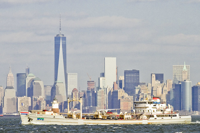
One such as myself is always eager to witness a DEP Sludge Boat splashing by. That’s the MV North River heading towards the Port Richmond sewer plant found a mile or so up the Kill Van Kull.

– photo by Mitch Waxman
Marjorie B. McAllister also happened by, and the bright red tug was towing a fuel barge. Even when it seems that a tug is pushing a barge, it’s still called “towing.”
“follow” me on Twitter- @newtownpentacle


