Posts Tagged ‘Greenpoint’
opiate gardens
“follow” me on Twitter at @newtownpentacle

– photo by Mitch Waxman
Imagine the surprise exhibited by Our Lady of the Pentacle and your humble narrator, when we raised the periscope from the bunker this morning, and found that the world above was intact and that the veracity and reliability of the Mayan Calendar had been overstated. Oh well, maybe next time.
Accordingly, back to the business at hand, and familiar places.

– photo by Mitch Waxman
Witness, if you wouldst, this fascinating scene observed in noble Greenpoint’s northwestern quarter, specifically the warren of mostly industrial streets which span the area between Provost Street and Mcguinness Blvd. The van pictured in the shot appears to have suffered a bit of damage, perhaps running afoul of the Hulk.

– photo by Mitch Waxman
This van’s repair job displays a purity of the Brooklyn, and particularly Greenpoint, mentality which would be difficult to explain to outsiders. Such displays of reckless engineering, utilitarian ingenuity, and disregard for the safety of passengers- are one of the reasons that your humble narrator is thankful for the distinct lack of apocalyptic conditions discovered this morning.
indefinable odors
“follow” me on Twitter at @newtownpentacle
This is a reblog of the post “indefinable odors“, which focused in on the little commented Hunters Point Avenue Bridge. Sorry for the repeat, fresh and new stuff is in the pipes.

– photo by Mitch Waxman
Down by Dutch Kills, one must persevere to maintain some inkling of hope for the future of mankind.
Saying that, however, in its own way Dutch Kills is actually quite a lovely place- as storied industrial centers which have seen better days typically are. A canalized waterway, Dutch Kills is a tributary of that languid cautionary tale known as the Newtown Creek, and has been isolated for several seasons from its principate source by emergency bridge construction and a changing industrial landscape. I’m down here a lot of course, most recently in the “from some point in space” posting of November 3rd, which includes an intriguing set of high elevation shots of the area which I recently managed to capture.
from nyc.gov
Hunters Point Avenue is a two-lane local City street in Queens. Hunters Point Avenue is oriented east-west and extends from 21st Street to the Long Island Expressway/Brooklyn Queens Expressway interchange in Queens. The avenue is parallel to and approximately one block south of the Long Island Expressway. The Hunters Point Bridge over Dutch Kills is situated between 27th Street and 30th Street in the Long Island City section of Queens, and is four blocks upstream of the Borden Avenue Bridge. It is a bascule bridge with a span of 21.8m. The general appearance of the bridge has been significantly changed since it was first opened in 1910. The bridge provides a channel with a horizontal clearance of 18.3m and a vertical clearance, in the closed position, of 2.4m at MHW and 4.0m at MLW. The bridge structure carries a two-lane, two-way vehicular roadway with sidewalks on either side. The roadway width is 11.0m, while the sidewalks are 1.8m wide. The width of the approach roadways vary from the width of the bridge roadway. The west approach and east approach roadways are 13.4m and 9.1m, respectively.
The first bridge at this site, a wooden structure, was replaced by an iron bridge in 1874. That bridge was permanently closed in 1907 due to movement of the west abutment, which prevented the draw from closing. It was replaced in 1910 by a double-leaf bascule bridge, designed by the Scherzer Rolling Lift Bridge Company. The bridge was rebuilt in the early 1980′s as a single-leaf bascule, incorporating the foundations of the previous bridge.

– photo by Mitch Waxman
Seldom commented, the Hunters Point Avenue Bridge segments Dutch Kills neatly, and has done so for nigh on a century now. The marshes and streams which once typified the area before the advance of railroad and vast agglutination of industrial installation are long gone, relegated to subterranean sewers and masonry clad spillways, but a century ago- the Hunters Point Avenue Bridge (and its predecessors) allowed egress between the terrestrial isolation of the Long Island City center and the rest of western Queens.
The NY Times, in 1908, commented that Long Island City might someday be known as “A city of bridges” due to the many crossings over the tributaries of the Newtown Creek and the presence of mighty Queensboro at its center.
from federalregister.gov
The Hunters Point Avenue Bridge, at mile 1.4, over the Dutch Kills has vertical clearances of 8 feet at mean high water and 13 feet at mean low water. The existing regulations for the Hunters Point Avenue Bridge in 33 CFR 117.801(d) require the draw to open on signal if at least a one-hour advance notice is given to the drawtender at the Grand Street/Avenue Bridge, the NYCDOT Radio Hotline, or NYCDOT Bridge Operations Office. In the event the drawtender is at the Roosevelt Island Bridge or the Borden Avenue Bridge, up to an additional half-hour delay may occur.
The bridge owner, the New York City Department of Transportation (NYCDOT), submitted bridge opening log data to the Coast Guard for review. The bridge owner plans to operate these bridges with multiple crews of drawtenders. The two-hour advance notice should allow sufficient time for the crews to operate these bridges due to the close proximity of the bridges to each other. Recent yearly openings have been relatively low which will allow the bridge owner to utilize the roving crew concept and still meet the needs of navigation.

– photo by Mitch Waxman
The Hunters Point Avenue Bridge (the 1910 version) was configured differently than the modern structure when first built, although the original was constructed for some $95,214 from plans by the Scherzer Rolling Lift Bridge Company with the dirty work performed by the Duseath Engineering Company of 114 Liberty St. NY. As you’d imagine, there is a certain logic behind the esoterica presented about this obscure little bridge found in a literal “industrial backwater” in Queens.
But… I can’t tell you what is is yet… (it was a Bridge centennial parade)
from nysdot.gov
About 1900, most of the Newtown Creek was bulkheaded and occupied by about fifty industrial properties. Undeveloped or less developed sections without bulkheads included Dutch Kills, about 2,000 feet of shoreline in Queens just above Dutch Kills with two LIRR lighterage piers, about 1,000 feet of shoreline in Queens near the Penny Bridge, and about 3,500 feet of shoreline downstream of Maspeth Avenue in Brooklyn.15 Dutch Kills, and the Queens side of Newtown Creek, just upstream of Dutch Kills, were developed circa 1905-1912, largely through the efforts of the Degnon Terminal & Realty Company. The Degnon firm created an industrial park with rail and marine access around Dutch Kills between about Hunters Point and 47th Avenue, Dutch Kills subsequently was included within USACE dredging projects. Without federal assistance, Degnon created a 150-foot-wide channel with 2,400 feet of bulkhead, including a turning basin. To create rail links to the development, Degnon helped the LIRR build a new 1,000-acre freight terminal circa 1907 along Newtown Creek east of Dutch Kills on property bought from Calvary Cemetery, including several short piers intended to handle heavy freight such as brick, coal, lumber, and ice. From this terminal, a private Degnon Terminal Railroad was created, largely through local streets. On newly filled marshy margins of Dutch Kills, Degnon Terminal & Realty promoted industrial development both on and away from the water. One iron works and several large building materials firms occupied the Degnon waterfront by the early 1920s. Reconstruction of the two movable bridges over Dutch Kills circa 1908-10 contributed to these developments. On other Degnon lots, large firms included the American Eveready Company and the American Chiclet Company, respective makers of batteries and candy.16 Facilitating this growth was the construction of the Queensboro Bridge (1909) and the start of the operation of the IRT subway line in 1917.

– photo by Mitch Waxman
Unfortunately, I can’t announce the news yet… Let’s just say that it would be a good idea to leave the 11th of December open, and that Long Island City is terrible in its grandeur during the winter months.
More on this will be forthcoming by the end of the week.
from wikipedia
Edward Byrne began his civil engineering career in 1886 with the New York City Aqueduct Commission on the construction of the Croton Water Supply System. It is of interest that on this project he met Robert Ridgway, who also was destined to become a distinguished engineer and an outstanding civil servant.
From 1889 to the close of 1897, Byrne worked on highways and bridges for the old Department of Public Works of New York City.
On January 1, 1898, he joined the Department of Bridges and began a striking and noteworthy service which ended in November, 1933, with his resignation from the position of Chief Engineer of the Department of Plant and Structures (the successor of the Bridge Department), in order to assume the duties of Chief Engineer of the Triborough Bridge. His thirty-six years of service in the Department of Bridges, and its successor, the Department of Plant and Structures, may be divided into two periods.
Borden Avenue Bridge
During this period, he was in charge of bridge construction and maintenance, supervising the construction of the Willis Avenue Bridge over the Harlem River, the Vernon Avenue Bridge, the Borden Avenue and Hunters Point Bridges over Dutch Kills, and the old bridge over Flushing River.

– photo by Mitch Waxman
Also, as a note:
I get asked all the time what these signs mean, what they indicate, and how seriously they should be regarded. The powers that be don’t make it easy to find out, for despite the “for more information” attribution, the City doesn’t go into much detail at nyc.gov/dep about them. Partly, this is due to the vogue followed by municipal authorities in recent years which allows private contractors to perform public work. The contractor is under no obligation to release their work into the public domain, as government workers are, and many important details about our metropolis ends up hidden behind corporate firewalls.
Here’s a little of the Batman type detection required to penetrate a purposely obtuse subject, which is a skill I’ve been developing over the lifetime of this, your Newtown Pentacle.
Quoting from hydroqual.com
The Bowery Bay WPCP is permitted by the NYSDEC under SPDES permit number NY-0026158. The facility is located at 43-01 Berrian Blvd., Astoria, NY, 11105 in the Astoria section of Queens, on a 34.6 acre site adjacent to the Rikers Island Channel, leading into the Upper East River, bounded by Berrian Blvd. and Steinway Street. The Bowery Bay WPCP serves an area of approximately 16,105 acres in the Northwest section of Queens, including the communities of KewGarden Hills, Rego Park, Forest Hills, Forest Hills Gardens, North Corona, South Corona, Lefrak City, Elmhurst, East Elmhurst, Jackson Heights, Maspeth, Woodside, Sunnyside Gardens, Sunnyside, Hunters Point, Long Island City, Astoria, Astoria Heights, Steinway, Ravenswood, and Roosevelt Island.
and from the same document this text and chart
The Low Level service area contains 46 regulators, of which 19 interconnected regulators discharge to the Newtown Creek during wet weather through the 13 CSOs. Of these 13 CSOs, 6 discharge to the tributary Dutch Kills (BB-004, 009, 010, 026, 040, and 042), and 6 discharge to Newtown Creek(BB-011, 012, 013, 014, 015, and 043). An additional 2-feet, 8-inches x 4-foot outfall, BB-049, is listed in the Bowery Bay WPCP SPDES permit as discharging to Dutch Kills near 21st Street, but no further information is available such as which regulator it is connected to.

fevered state
“follow” me on Twitter at @newtownpentacle

– photo by Mitch Waxman
Gaze in wonder upon the fabled Newtown Creek of the 21st century, whereupon a tug of the Poling and Cutler towing organization wrestles a fuel barge in a westerly course toward the East River. A famously repeated phrase offered by your humble narrator boldly states that “in the late 19th and early 20th century, Newtown Creek carried more commercial traffic than the entire Mississippi River”, a statement which often causes listeners to roll their eyes. It is inconceivable, given the modern appearance of the Creek and its banks, to believe this statement. Some ask me whether or not tugs and barges even operate along the Newtown Creek in this dystopian future we have all found ourselves living in.

– photo by nycma.lunaimaging.com, September 11, 1903
Gaze, thereby, upon the Newtown Creek of 1903. This is roughly the same spot, with the Chelsea fiber mill (modern day Manhattan Avenue and GMDC) on the southern (left) or Greenpoint bank and the Newtown Creek towing company docks on the right or LIC bank (modern day Vernon Blvd. street end). Another shot emanating from the NYC Municipal Archives, this is one of the few extant photographic records of the Newtown Creek’s zenith as the “workshop of America” at the height of the second industrial revolution.
lurk unseen

– photo by Mitch Waxman
As mentioned a day or two ago, your humble narrator is currently incapacitated due to a lower back injury. Manifestations of my inferior physical robustness such as this pop up occasionally, serving as reminders of a weak and sickly childhood. Seldom does one go more than a few weeks without some new complaint, which when compounded with the diminishment of advancing years, paints dire portents about long term survival.
from wikipedia
Back pain is regularly cited by national governments as having a major impact on productivity, through loss of workers on sick leave. Some national governments, notably Australia and the United Kingdom, have launched campaigns of public health awareness to help combat the problem, for example the Health and Safety Executive’s Better Backs campaign. In the United States lower back pain’s economic impact reveals that it is the number one reason for individuals under the age of 45 to limit their activity, second highest complaint seen in physician’s offices, fifth most common requirement for hospitalization, and the third leading cause for surgery.

– photo by Mitch Waxman
Those around me grow increasingly wary watching this process working upon me. Extraordinary effort at maintaining an appearance and facade of bon vivant and vigor fall apart when these sudden spells occur. Unfortunately, this is my true self- timorous and wracked with an inconceivable number of physical maladies. For the moment, it is difficult to surmount a shallow set of stairs, let alone perform a perambulation.
from wikipedia
The lumbar region (or lower back region) is made up of five vertebrae (L1-L5). In between these vertebrae lie fibrocartilage discs (intervertebral discs), which act as cushions, preventing the vertebrae from rubbing together while at the same time protecting the spinal cord. Nerves stem from the spinal cord through foramina within the vertebrae, providing muscles with sensations and motor associated messages. Stability of the spine is provided through ligaments and muscles of the back, lower back and abdomen. Small joints which prevent, as well as direct, motion of the spine are called facet joints (zygapophysial joints).

– photo by Mitch Waxman
Pain, aside from the psychological torments and thwarted ambitions which are part and parcel of my daily round, is something I am quite used to. The particular complaint in my lower back has all the appearance of something temporary, a visitor for the holidays sent to remind me that time is short, and that despite all- I am human, all too human. At least I still have a heated and electrified house to live in, which seems to be a blessing in the New York City area these days. My little dog, however, seems quite concerned about me and has been sticking to my heels.
from wikipedia
Before the relatively recent discovery of neurons and their role in pain, various different body functions were proposed to account for pain. There were several competing early theories of pain among the ancient Greeks: Aristotle believed that pain was due to evil spirits entering the body through injury, and Hippocrates believed that it was due to an imbalance in vital fluids. In the 11th century, Avicenna theorized that there were a number of feeling senses including touch, pain and titillation, but prior to the scientific Renaissance in Europe pain was not well-understood, and it was thought that pain originated outside the body, perhaps as a punishment from God.
rough handling
“follow” me on Twitter at @newtownpentacle
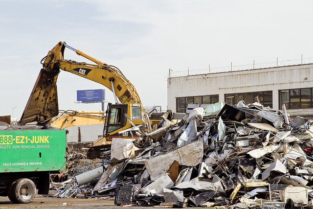
– photo by Mitch Waxman
Rejoice, for this is the day when men and women return to their ancestral villages and seaside hamlets, gathering beneath cobbled roofs and behind garret windows to celebrate “America Recycles Day”. Children shall be offered solemn pledges and vast ritual amalgamations of litter will be assembled for display and dissemination. Many and varied will be the manifestations of this occasion, which is ultimately rooted in the solemn traditions set down by a group known as “Keep America Beautiful”.
from wikipedia
America Recycles Day (ARD) is the only nationally recognized day dedicated to encouraging Americans to recycle and buy recycled products. ARD is celebrated annually on November 15. The World Recycling Day celebrated in most countries, though falls on July 8. Thousands of events are held across the U.S. to raise awareness about the importance of recycling and to encourage Americans to sign personal pledges to recycle and buy products made from recycled materials.

– photo by Mitch Waxman
Gaze in astonished wonder at the industry of man, and the tyranny of wealth. Imagine, if you would, the raw tonnages of refined metals displayed in these shots. Surely, just in today’s posting, we are seeing a greater amount of waste metals than an entire nation might be capable of producing just a scant 200 years ago. We waste so much, and our culture- if nothing else- will prove itself a boon to future archaeologists.
The multitudinous middens of the megalopolis, well moistened with motor oil, will stand as our monument.
from wikipedia
Keep America Beautiful was founded in 1953 by consortium of American businesses (including founding member Philip Morris, Anheuser-Busch, PepsiCo, and Coca-Cola) nonprofit organizations, government agencies, and concerned individuals in reaction to the growing problem of highway litter that followed the construction of the Interstate Highway System, and an increasingly mobile and convenience-oriented American consumer. The original goal of the organization was to reduce litter through public service advertising (PSA) campaigns.
Keep America Beautiful conducted many local PSA campaigns early in its history. One of these early campaigns in Pennsylvania (PENNDOT), some attribute to having coined the term “litterbug”, as opposed to the New York Transit Authority. There is some confusion over the origin of the actual word “litterbug” due to several early uses of it in widespread public service advertisements. It was, in fact, coined by Paul B. Gioni, a copywriter in New York City who originated it for The American Ad Council in 1947. Keep America Beautiful joined with the Ad Council in 1961 to dramatize the idea that every individual must help protect against the terrible effects litter has on the environment.
A popular television campaign theme in 1963, with copy written by Paul B. Gioni who also coined the word “litterbug” in 1947, was “Every Litter Bit Hurts”. Another appeared in 1964 featuring character Susan Spotless. In 1970 KAB began distributing a free brochure; more than 100,000 copies were requested within 4 months.
On Earth Day 1971, a new campaign was launched with the theme “People Start Pollution. People can stop it” featuring the now iconic “Crying Indian” played by Iron Eyes Cody.

– photo by Mitch Waxman
Amongst those who tolerate my presence, some work in the recycling industry. A missive they ask a humble narrator to transmit reads as: “Recycle. Please. Don’t do it for us and our business, do it for your kids”. They continue that it’s probably already too late, and that the future is trashed. Perhaps, just perhaps, they are wrong. Until the ultimate answer is found to this disposables issue, they are likely being far more pragmatic than the rest of us. It is they, after all, who see the trucks tipping and collecting, and spend more time than they would like handling putrescent garbage as a loss leader.
Figuring out when, where and how to recycle in your community couldn’t be easier. Log on to www.americarecyclesday.org and select the “Find Recycling” tab and click on the Earth911.com logo. This will direct you their recycling resource page, where you can enter the item type and your zip code to find the nearest recycling facility.

– photo by Mitch Waxman
By no means should this humble narrator be considered a creature of primal intelligence, good hygiene, or high moral turpitude. Neither should it be inferred that the role of exemplar is claimed, as far as the contributions of my own household to the problem. A lone and singular advantage is that I am instead smart enough to realize how smart I’m not, and realize the shallow depths of my grasp on the situation. Around here, we just try not to be too loose with using things that can’t be washed, or reused, or cross purposed. How about you?
from wikipedia
Recycling statistics:
- 251 million – tons of trash in the United States
- 53.4 – percentage of all paper products recycled in the United States
- 32.5 – percentage of total waste that is recycled in the United States
- 100 – approximate percentage of increase in total recycling in the United States during the past decade
- 8,660 – number of curbside recycling programs in the United States in 2006
- 8,875 – number of curbside recycling programs in the United States in 2003
- 95 – percentage of energy saved by recycling an aluminum can, compared with manufacturing a new one
- 4.6 – pounds of trash per person per day in the United States (most in the world)
- 1.5 – pounds of recycled materials per person per day in the United States


