Posts Tagged ‘railroad’
blurred and fragmentary

– photo by Mitch Waxman
The scions who run the Newtown Creek Alliance declared that we all gather for a meeting recently, and not wanting to be mocked in absentia (rather in person), your humble narrator set out for the gathering. Only issue with this caucus was that it was being held in far off Ridgewood at the Onderdonk house, which is a pretty long walk from Newtown Pentacle HQ here in Astoria. After having moved things around, schedule wise, a vast scuttle was instituted. The shot above depicts the East Branch of the Newtown Creek at its terminus on Metropolitan Avenue.

– photo by Mitch Waxman
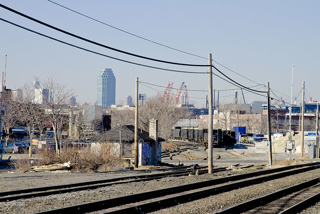
Along the way, I decided to check out the Scott Avenue footbridge. This is a rusted metal and rotting concrete structure which rises over the tracks of the LIRR’s Bushwick Branch, allowing pedestrian traffic egress to Flushing Avenue- a structure seen from distance but never traversed. Due to the aforementioned distance from my quarters, it will be admitted, this is the section of the Newtown Creek watershed with which I am the least familiar and one which still offers pleasant surprises when visited. In the shot above, what you’re looking at is the northward facing tracks of the Bushwick Branch as they head towards Fresh Ponds.

– photo by Mitch Waxman
The inverse view, to the south and the infinity of Brooklyn. The train cars, homogenous and numerous, are awaiting service by the NY and Atlantic freight railway. What is colloquially known as the “garbage train”, they are gathered for usage at the Varick Street Waste Management facility which is nearby and adjoins the bitter end of the Newtown Creek tributary known as English Kills near Johnson and Morgan avenues. The undefended border of Brooklyn and Queens is also present in this shot, although I cannot tell you exactly where. Additionally, I am unsure as to whether these cars were loaded with their putrescent charge when I gathered these images.

– photo by Mitch Waxman
The Newtown Pentacle postings “approaching locomotive” and “skillfully wafted” discuss the Bushwick Branch and the Waste Management facility at Varick Street in some detail, why not check them out? Luckily, lords and ladies, your humble narrator goes to these spots so you don’t have to. If you did want to see some of the wonders described within these postings- why not consider coming on one of the upcoming excursions I’ll be leading?

for an expanded description of the October 20th Newtown Creek tour, please click here
for more information on the October 27th Newtown Creek Boat Tour, click here

for more information on the November 9th Newtown Creek Magic Lantern Show, click here

for an expanded description of the November 11th Newtown Creek tour, please click here
budding branches

– photo by Mitch Waxman
Returning from scouting a tour in hoary Greenpoint recently, your humble narrator was lucky enough to encounter the shot above waiting for me on Hunters Point avenue in Queens. Whereas I do seem to take quite a few shots of locomotives, I am no “railfan”. A true railfan or “foamer” obsesses over schedules and would be waiting for this train to pass. With me, it’s just pure serendipity. This is, of course, an Amtrak train heading for the Belmont tunnels which offer egress from Long Island to Manhattan via the Sunnyside Yards rail complex in Queens.

– photo by Mitch Waxman
In many ways, one can understand the apathy felt by the Manhattan elites toward Long Island City, for what do they see of the wonders hidden therein from the East River? Even the Newtown Creek appears to be just a simple bay from the water, another unremarkable inlet on the western coastline of a Long Island.

– photo by Mitch Waxman
Perhaps this is why I’ve been drawn to conducting all of these tours. Famously, the Newtown Creek Alliance motto is “Reveal, Restore, Revitalize”, and in my capacity as group historian- I’m the “reveal” guy. Next Saturday, I’m going to be doing some of that “revealing”- there are still a few tickets left for “the Poison Cauldron” walk- do come along, if you dare.

– photo by Mitch Waxman
Long have I been reluctant to bring people to this place.
For several months now, your humble narrator has been narrating in a not so humble fashion while leading boat and walking tours of the Newtown Creek watershed.
Literally hundreds of people have attended either the “Thirteen Steps around Dutch Kills“, “Insalubrious Valley“, or “Newtown Creek Boat Tour” events this year- and one question has been asked by all- “What about the Greenpoint Oil Spill?”.
Next week- a group of enthusiasts will be assembling, under the auspices of Atlas Obscura, to explore the lamentable “Poison Cauldron” of the Newtown Creek.
There are still tickets available, should you care to witness the place prior to its forthcoming demolition.

– photo by Mitch Waxman
Down Under the Kosciuszko Bridge Onramp, or DUKBO, is the name I’ve assigned to this lunar landscape of industrial mills and waste transfer stations which lines the Brooklyn side of the Creek. This year is functionally the last time you will be able to witness this place, as the Kosciuszko Bridge replacement project will be kicking into high gear in the spring of 2013.
For the urban explorer and photographer crowd, this is a wonderland of shattered streets and rusted infrastructure which will soon be eradicated from all but living memory.

– photo by Mitch Waxman
The tour will tell the story of Standard Oil at its start and cross over the Greenpoint Oil Spill’s heart, revealing that lost world of industrial aspiration and 20th century dissolution which lies less than a mile from the geographic and population centers of New York City.
In the past, I’ve described the area as “Mordor” at this, your Newtown Pentacle, and the Tolkien analogy is apt. The very air you breathe is a poisonous fume, the water is hopelessly tainted with bizarre combinations and millions of gallons of petroleum and industrial chemicals, the soil is impregnated with heavy metals, asbestos, and truly- who can guess all there is that might be buried down there?
An odd concentration of food distribution, waste transfer and garbage handling facilities, and energy industry plants make the area remarkable, and everywhere you look will be a “colour“- a bizarrely iridescent sheen which resembles no wholesome nor familiar earthly color but is instead like something from out of space- coating every bit of broken masonry and the sweat slicked skin of laborer and passerby alike.

– photo by Mitch Waxman
Standard offer copy follows:
Meetup at the corner of Kingsland and Norman Avenues in Greenpoint at 11 on Saturday, August 25th.
We will be exploring the petroleum and waste transfer districts of the Newtown Creek watershed in North Brooklyn. Heavily industrialized, the area we will be walking through is the heart of the Greenpoint Oil Spill and home to scores of waste transfer stations and other heavy industries. We will be heading for the thrice damned Kosciuszko Bridge, which is scheduled for a demolition and replacement project which will be starting in 2013. Photographers, in particular, will find this an interesting walk through a little known and quite obscure section of New York City.
Be prepared: We’ll be encountering broken pavement, sometimes heavy truck traffic, and experiencing a virtual urban desert as we move through the concrete devastations of North Brooklyn. Dress and pack appropriately for hiking, closed toe shoes are highly recommended- as are a hat or parasol to shield you from the sun.
Bathroom opportunities will be found only at the start of the walk, which will be around three hours long and cover approximately three miles of ground. Drivers, it would be wise to leave your cars in the vicinity of McGolrick Park in Greenpoint.
Click here for tickets, and as always- a limited number of walk ups will be welcomed- but for safety reasons we need to limit the group to a manageable size. Contact me at this email if you desire further details.
vain presence

– photo by Mitch Waxman
One feels as if enough attention hasn’t been paid to Queens of late, and special efforts to program my walks have been accordingly undertaken. Ambitions and obligations have drawn me, more often than not, to Brooklyn in the last few months and it seems as if I spend my days walking back and forth to the Greenpoint Avenue Bridge more than anywhere else.
I haven’t been east of Forest Hills so far this year, nor south of Ridgewood- for instance.

– photo by Mitch Waxman
Special attentions must, as always, be paid to the area around Court Square, Queens Plaza, and Hunters Point- all of which are undergoing thunderous transformations and metamorphoses. Blink just once, it seems, and an entire neighborhood might be transformed into something new and unrecognizably shiny. That thing which cannot possibly exist in the cupola of the Sapphire Megalith doesn’t ever blink, as its singular eye is lidless and likely triple lobed, but it isn’t talking.

– photo by Mitch Waxman
Unadulterated and unbound, Western Queens never fails to disappoint the itinerant photographer plying its lanes. Rhapsodic, the lessons and parables freely observable and extant both inform and instruct. It is said, by physics scholars and quantum mechanists, that reality is altered merely by the act of observation itself.
A humble narrator, therefore, hopes to profoundly alter reality in the coming weeks.
____________________________________________________________________________
Click for details on Mitch Waxman’s
Upcoming walking and boat tours of Newtown Creek, and Staten Island’s Kill Van Kull
June 30th, 2012- Working Harbor Committee Kill Van Kull walk
for June 30th tickets, click here for the Working Harbor Committee ticketing page
July 8th, 2012- Atlas Obscura Walking Tour- The Insalubrious Valley
for July 8th tickets, click here for the Atlas Obscura ticketing page
July 22nd, 2012- Working Harbor Committee Newtown Creek Boat Tour
![]()
graceful valleys

– photo by Mitch Waxman
A structure which may be discerned in the distance, within the shot above, at Sunnyside Yards is the 35th street or Honeywell Bridge. The location of the camera which captured it was astride the 39th street or Harold Avenue bridge at Steinway Street, where ongoing construction has rendered a hidden breach in the fencing which normally frustrates its purpose by obfuscating the view.
For a discussion of another of the bridges which cross these titan rail yards, click here for the posting “incaculable profusion”, examining the Thomson Avenue Viaduct to the west.
from forgotten-ny.com
When the Yards were built, Long Island City, to the north of the Yards, was effectively cut off from Sunnyside and Maspeth, to the south. Viaducts were built at Queens Boulevard (which was itself under construction in 1910), Honeywell Street, Harold Avenue, and Thomson Avenue. Laurel Hill Avenue (43rd Street) Gosman Avenue (48th Street) and Woodside Avenue were carried under the railroad.

– photo by Mitch Waxman
A paucity of such apertures in the fence lines around the yards exists, which is appropriate in this age of heightened vigilance, and the discovery of something large enough to accept the lens of a dslr is tantamount to observing a unicorn to one such as myself. Of course in the midst of all this faux security and theater, I can show you a dozen different places where you could work mischief if you chose to. Such is always the case with large installations like this one, however, and illegal trespass is not the Newtown Pentacle way.
The real estate happy characters in Manhattan are desirous to rob me of this vista, as evidenced in the document linked to below, describing the feasibility and benefits of decking over these yards and expanding the population of western Queens by tens of thousands. It seems to be a plan of some vintage, however, crafted before the financial crisis and concurrent economic crisis experienced by the region and country at large since 2008 (when do we get to start calling this a depression?).
from nyc.gov
Sunnyside Yards, one and three-quarters of a mile long and 1,600 feet across at its widest point, is the largest site in this inventory. The total deckable airspace of its 14 parcels – over 167 acres – is more than double the size of the next largest airspace site, the 74-acre NYCT Coney Island Maintenance Shop and Yards (K5000). This one corridor contains around one-sixth of the entire deckable airspace in this inventory.
The potential for large scale land uses above these yards is extraordinary. With the possible exception of Staten Island’s west shore, no other large tracts of “vacant” land remain in the City. Moreover, Sunnyside Yards is defined by a surrounding context of relatively dense development and plentiful transit access.
At the behest of former Deputy Mayor for Economic Development and Rebuilding Daniel Doctoroff, DCP’s Housing, Economic and Infrastructure Planning (HEIP) unit conducted a preliminary analysis concerning the viability of decking over and developing Sunnyside Yards. The HEIP unit determined that the most desirable sites within the yards were two roughly rectangular areas running from the southwest to the northeast; the northern third of both sites is located northeast of Queens Boulevard.

– photo by Mitch Waxman
These trusses which fly over the Sunnyside Yards are actually rather new. The Honeywell and Harold Bridges (39th and 35th streets), for instance, were totally rebuilt recently. The Honeywell Bridge reopened in 2003 after having laid fallow and closed to pedestrian and vehicle traffic for better than 20 years. The night shot above, by the way, is betrayed by its format and shape as being from my trusty old Canon G10, which is still in service at this- your Newtown Pentacle.
from nytimes.com
In 1979, inspectors from the city’s Department of Transportation judged the 1,600-foot four-lane bridge, which was built in 1909, to be on the verge of falling down. The inspection occurred near the end of an era in which the city, nearly broke and as exhausted as a disco dancer at dawn, partly balanced its budget by deferring maintenance on bridges. Tom Cocola, a department spokesman, said once costs had been cut by removing the bridge from the city’s regular inspection schedule, ”we probably just forgot about it.”
proper turns
– photo by Mitch Waxman
Once upon a time, this wasn’t the proverbial “wrong side of the tracks”, rather this was the center of town. 18th century residents would ask “what on earth could have happened to Maspeth Creek” were they able, and “where is the Town Dock which DeWitt Clinton himself used- where is it”?
What happened?

– photo by Mitch Waxman
19th Century residents and passerby would inquire what disaster occurred, that Haberman’s and Nichols Chemical and all of Berlin and Blissville have disappeared and been forgotten? What has happened to the great factories, the mills, and the hustle and bustle? Where have all the railroads gone, can one paltry freight line actually be charged with servicing all of Newtown Creek?

– photo by Mitch Waxman
For your humble narrator, a good place to ponder this sort of question has always been the Clinton Diner.
This little oasis has hosted a full group from a bus tour I helped conduct, acts a central meeting point for all sorts of Newtown Creek functions, and has provided a much needed cup of coffee and clean rest room to a half frozen yet quite humble narrator on more than one occasion.
It’s also sitting pretty much on a shoreline that Maspeth Creek once flowed past.

– photo by Mitch Waxman
Accordingly, a “Happy Valentine’s” day shout out to the Clinton Diner is offered today.
It would be meaningless to offer you shots of its interior as it has been featured more than once in the cinema. Witness below the trademark dolly shot of Martin Scorcese in Goodfellas… The window booth that DeNiro and Liotta are sitting in is the one with the “Go Giants” signage in the shot above.
And a happy valentine’s day greeting is offered to you as well, lords and ladies… or a giddy Lupercalia.
The Clinton Diner is found at 5626 Maspeth Ave., Maspeth, NY 11378-2248 (718) 894-3475


