Archive for the ‘Brooklyn’ Category
approaching triumph
Infrastructure pornography, gratuitous and forbidding, in today’s post.
Also, I’ll be at Brooklyn Brainery on February 27th presenting “the Newtown Creek Magic Lantern Show.”

– photo by Mitch Waxman
Gaze upon the terrible scale of the Verrazano Narrows Bridge, connecting Brooklyn with… Staten Island… Bridges are on my mind today, especially the ones that connect Long Island with other extant land masses scattered about the archipelago.
Today will be just a lot of photos, and your humble narrator will be taking advantage of the short interval of warmth offered today. Out and about, looking at things- that’s me.
from wikipedia
The bridge is owned by the City of New York and operated by MTA Bridges and Tunnels, an affiliate agency of the Metropolitan Transportation Authority. Interstate 278 passes over the bridge, connecting the Staten Island Expressway with the Gowanus Expressway and the Belt Parkway. The Verrazano, along with the other three major Staten Island bridges, created a new way for commuters and travelers to reach Brooklyn, Long Island, and Manhattan by car from New Jersey.
The bridge was the last great public works project in New York City overseen by Robert Moses, the New York State Parks Commissioner and head of the Triborough Bridge and Tunnel Authority, who had long desired the bridge as a means of completing the expressway system which was itself largely the result of his efforts. The bridge was also the last project designed by Chief Engineer Othmar Ammann…

– photo by Mitch Waxman
East River Bridge #1, or East River Suspension Bridge #1, or Brooklyn Bridge from Brooklyn.
from nyc.gov
The Brooklyn Bridge opened in 1883. At the time, it was the longest suspension bridge. It has been designated a National Historic Landmark by the National Park Service, and a New York City Landmark by the Landmarks Preservation Commission.

– photo by Mitch Waxman
East River Bridge #3, or Manhattan Bridge, from the water.
from nyc.gov
The youngest of the three DOT East River suspension bridges, construction began on October 1, 1901. The bridge opened to traffic on December 31, 1909 and completed in 1910. The Bridge’s total length is 5,780 feet from abutment to abutment at the lower level; and 6,090 feet on the upper roadways from portal to portal. Its main span length is 1,470 feet long and each of its four cables is 3,224 feet long. The Bridge was designed by Leon Moisseiff (1872-1943)…

– photo by Mitch Waxman
East River Bridge #2, Williamsburg Bridge, from Manhattan.
from nyc.gov
When it opened in 1903, the Williamsburg Bridge was the longest suspension bridge in the world, with a span of 1600 feet and a total length of 7308 feet and the first with all-steel towers. The 310-foot steel towers support four cables, each measuring 18_ inches in diameter and weighing 4,344 tons. In all, nearly 17,500 miles of wire are used in the cables that suspend the bridge 135 feet above the East River. The massive stiffening trusses were designed not only to withstand high winds, but also to support rail traffic on the deck.

– photo by Mitch Waxman
East River Bridge #4, Queensboro Bridge, from Long Island City.
from nyc.gov
The bridge was constructed between 1901 and 1909 and was opened to the traffic on June 18, 1909. A collaboration between the bridge engineer Gustav Lindenthal (1850-1935) and architect Henry Hornbostel, the main bridge is 3,725 feet long, the longest of the East River Bridges. The overall length of the bridge including the Manhattan and Queens approaches is 7,449 feet.
The site is an ideal location for a bridge as Roosevelt Island provides a convenient footing for the piers. Seventy-five thousand tons of steel went into the original bridge and its approaches. Its original cost was about $18 million, including $4.6 million for land. At the time of completion, it was not only the longest cantilever bridge in the United States, but also was designed for heavier loads than any other bridges.

– photo by Mitch Waxman
Welfare Island, aka Roosevelt Island Bridge, from Roosevelt Island looking towards Queens.
from nyc.gov
The Roosevelt Island Bridge is a tower drive, vertical lift, movable bridge across the East Channel of the East River between the borough of Queens and Roosevelt Island, New York City. The span length is 418 feet. It was known as the Welfare Island Bridge when it was first opened to traffic in 1955.

– photo by Mitch Waxman
Triborough Bridge, aka Robert F Kennedy Bridge, from Astoria, Queens.
from wikipedia
Construction began on Black Friday in 1929, but soon the Triborough project’s outlook began to look bleak. Othmar Ammann, who had collapsed the original design’s two-deck roadway into one, requiring lighter towers, and thus, lighter piers, saving $10 million on the towers alone, was enlisted again to help guide the project. Using New Deal money, it was resurrected in the early 1930s by Robert Moses, who created the Triborough Bridge Authority to fund, build and operate it. The completed structure was opened to traffic on July 11, 1936.
The total cost of the bridge was more than $60 million, one of the largest public works projects of the Great Depression, more expensive even than the Hoover Dam. The structure used concrete from factories from Maine to Mississippi. To make the formwork for pouring the concrete, a whole forest on the Pacific Coast was cut down.

– photo by Mitch Waxman
Hell Gate Bridge, also from Astoria, Queens.
from wikipedia
The Hell Gate Bridge (originally the New York Connecting Railroad Bridge or The East River Arch Bridge) is a 1,017-foot (310 m)[3] steel through arch railroad bridge in New York City. The bridge crosses the Hell Gate, a strait of the East River, between Astoria, Queens and Wards Island in Manhattan.
The bridge is the largest of three bridges that form the Hell Gate complex. An inverted bowstring truss bridge with four 300-foot (91.4 m) spans crosses the Little Hell Gate (now filled in); and a 350-foot (106.7 m) fixed truss bridge crosses the Bronx Kill (now narrowed by fill). Together with approaches, the bridges are more than 17,000 feet (3.2 mi; 5.2 km) long.
“follow” me on Twitter- @newtownpentacle
complicated padlock
Williamsburgh Savings Bank, part 2.

– photo by Mitch Waxman
In yesterday’s post – “gleaming sands” – the story of the Williamsburgh Savings Bank building at 175 Broadway in Brooklyn was described in some detail. As promised, in today’s post, a few more shots from inside the recently restored structure.

– photo by Mitch Waxman
In the middle of the room is an ornate safe, which attracted no small amount of attention from the crowd that Atlas Obscura had brought in. This looked like the sort of safe which a cowboy might attempt to open with dynamite in a western movie.

– photo by Mitch Waxman
We were told that the safe is of European make and design, manufactured specifically in France. Of course, that’s 1875 France, which was a very different France than the one which we’re stuck with today.

– photo by Mitch Waxman
On the inside of the door were two medallions, which were “maker’s marks.”

– photo by Mitch Waxman
Emperor Napoleon the Third is commemorated on one of them.

– photo by Mitch Waxman
Alongside the safe was a mechanism which acted as a sort of intercom to other sections of the building. This is not an electronic system, it should be noted, you simply spoke or whistled into the appropriate tube.

– photo by Mitch Waxman
The domes kept on gathering my attention. The ornamentation and detail up there were incredible. Your humble narrator is still analyzing the iconography contained therein.
“follow” me on Twitter- @newtownpentacle
gleaming sands
How the other half lives, in today’s post.

– photo by Mitch Waxman
My pals at Atlas Obscura rang me up and asked if I’d be interested in shooting at one of their events in Brooklyn, and since this offered an opportunity to leave the house (a rare treat during this winter of frozen discontent), I packed up Our Lady of the Pentacle and my camera bag and we set off for Williamsburg. Now, I don’t spend a lot of time around these parts, can’t afford it, but its also nice to see how the other half lives.
from wikipedia
Williamsburg is a neighborhood of 113,000 inhabitants in the New York City borough of Brooklyn, bordering Greenpoint to the north, Bedford–Stuyvesant to the south, Bushwick and Ridgewood, Queens to the east and the East River to the west. The neighborhood is part of Brooklyn Community Board 1. The neighborhood is served by the New York Police Department (NYPD)’s 90th Precinct. In the City Council, the western and southern part of the neighborhood is represented by the 33rd District; and the eastern part of the neighborhood is represented by the 34th District.

– photo by Mitch Waxman
This is the Williamsburgh Savings Bank building at 175 Broadway, a building erected just 10 years after the Civil War. A famous structure, its the domed building you can’t help but notice when exiting the Williamsburg Bridge, at least when you’re on the Brooklyn side.
from wikipedia
The Williamsburgh Savings Bank was an important institution in Brooklyn, New York, from the mid-19th to the mid-20th centuries. A series of bank mergers brought it into the HSBC group late in the 20th century. (It is not to be confused with the nearby Dime Savings Bank of Williamsburgh, now known simply as the DIME, a rival local institution that has remained independent.) It is best remembered for two imposing headquarters buildings still standing, the domed original at 175 Broadway in Williamsburg, Brooklyn, designed by George B. Post, and the later Williamsburgh Savings Bank Tower.

– photo by Mitch Waxman
As transmitted by our hosts, the tale of the WSB includes decades of neglect, wear, and tear. The current owners acquired it just a few years ago (and of course it was controversial, it’s in North Brooklyn, not Queens) and set upon a radical architectural restoration of the bank. Pictured is the meticulous work found on the first of the interior domes.
from nyc-architecture.com
To build a new edifice for the WBS the board of trustees hired George B. Post (1837-1913), a man who had just finished the important Equitable Life Assurance Building (1868-1870), was at present finishing the Western Union Building (1873-1875), and who would later go on to design the icon of money, the market, and capitalism in 1903. Architecturally speaking and with vast hindsight, it was upon the hiring of Post that the WBS secured itself as a structural institution and landmark in Brooklyn. For it is through the tie to its architect that this structurally impressive building gains even more notoriety; George B. Post would later go on to design City College (1886-1906), the Brooklyn Historical Society (1881), the New York Stock Exchange (1903), and other notable buildings throughout the country.

– photo by Mitch Waxman
There were three buildings here, the 1875 original and an early 20th century addition (1906, I think) – both domed – and a 1940’s era office building of pedestrian design. The domed buildings were landmarked, but the office building was not and it was torn down. There are plans to erect a modern hotel on the property, a mammoth 40 story affair. The former bank will act as an event space for the hotel.
for a Landmarks Preservation Committee document generated by municipal authorities back in 1996, click here.

– photo by Mitch Waxman
This is the second dome, which I seem to recall as being of 1906 vintage, but might be misstating the date. The oculus in the center was actually boarded up during the Second World War and remained so until the restoration process began. In case you’re curious, yes, I laid down on the floor in the center of the room and shot straight up.
from ny.curbed.com
When Brooklyn hostel owner Juan Figueroa purchased the Williamsburgh Savings Bank for $4.5 million in 2010, the rumor was that he planned to convert the historic bank building into a hotel. That would have been difficult, though, since the structure is an exterior, interior, and national landmark. The actual plan, it turned out, was to meticulously restore it and turn it into an event space and banquet hall, and place a 40-story hotel right next door.

– photo by Mitch Waxman
The other half lives in Williamsburg, I’m told. The Brooklyn patois pronunciation for this neighborhood is “Willemsboig” and my parents – who used to bank with the company once located here – called it “Da Willemsboig Savins Banks.” They stayed with the company all the way till it became HSBC. That’s brand loyalty, folks. Back tomorrow with a few more shots from within the lush interior, including some details on the vault.
“follow” me on Twitter- @newtownpentacle
leading corridor
What’s good for the goose is good for the gander.

– photo by Mitch Waxman
As mentioned in posts last week, a couple of trips to coastal Brooklyn popped onto my schedule. In the case of today’s post, I was in South Brooklyn at the angle found twixt Red Hook and Cobble Hill, and crossing the street beneath the extremely drippy Gowanus Expressway.
from wikipedia
After the Verrazano Narrows Bridge, I-278 continues into Brooklyn on the Gowanus Expressway. Immediately after the bridge, the freeway comes to an eastbound exit and westbound entrance for the Belt Parkway. After this, a full interchange serves 92nd Street at which point I-278 becomes a single-level six-lane freeway. Along this road, one of the eastbound lanes serves as a high-occupancy vehicle lane. The Gowanus Expressway continues northeast into urban residential neighborhoods and reaches an eastbound interchange at Fort Hamilton Parkway and a westbound interchange at 86th Street. Turning more to the north, I-278 comes to a partial interchange at 65th Street, with an exit eastbound and entrance westbound. The road curves northwest at this point and comes to a directional interchange providing access to 3rd Avenue and the Belt Parkway.

– photo by Mitch Waxman
A confession, seldom do I actually pay attention to the minute details when photographing an area with which I’m not overly familiar. Instead, I go for the big shot, and use my lens at its widest angles. In the street, I have a lot to worry about – traffic, criminal underclasses and malign manifestations of the street culture, and so on. Often, when I’m at my desk and examining the shot qualitatively (focus and exposure rather than composition and esthetics etc.), something will jump out at me. Notice the blue van, which I didn’t until I was back at HQ.
from nyc.gov
…standing on a street, walkway of a bridge, sidewalk, or other pedestrian passageway while using a handheld device and not otherwise asserting exclusive use by any means, including physical or verbal, is not activity that requires a permit.

– photo by Mitch Waxman
So, there I stood, dirty black raincoat flapping about in the slipstream of truck and traffic and waving the camera about during a red light interval. Obviously, this registered in the mind of the driver of the blue van as suspicious activity, and he began to photograph me right back. The panopticon at work, lords and ladies, he saw something. Wonder if he said something?
from securetransit.org
Whether you’re following your regular commute route or on your way to a movie or meet up with friends, public transit is a key part of your day. You know public transit, and no one can spot something suspicious or out of place better than you.

– photo by Mitch Waxman
The 1984 scenario offered by Orwell has only come partially true in 2014. The State is indeed watching, and listening. Unfortunately, its usually “Little Brother” (as Cory Doctorow coined it) who is watching. This is all good though, as what is good for the goose is literally good for the gander, and the Brooklyn way is to keep an eye on the neighborhood. On this day, under the Gowanus Expressway, there were at least two surveillance devices active and pointing at each other. Mine and his. Mine was bigger.
from wikipedia
Big Brother is a fictional character in George Orwell’s novel Nineteen Eighty-Four. He is the enigmatic dictator of Oceania, a totalitarian state taken to its utmost logical consequence – where the ruling Party wields total power for its own sake over the inhabitants.
In the society that Orwell describes, everyone is under complete surveillance by the authorities, mainly by telescreens. The people are constantly reminded of this by the phrase “Big Brother is watching you”, which is the core “truth” of the propaganda system in this state.
Since the publication of Nineteen Eighty-Four, the term “Big Brother” has entered the lexicon as a synonym for abuse of government power, particularly in respect to civil liberties, often specifically related to mass surveillance.
“follow” me on Twitter- @newtownpentacle
constantly feeling
A walkabout in Red Hook, by the Gowanus.

– photo by Mitch Waxman
An assignment carried me out to the ancient harbor of South Brooklyn, Red Hook. After my business was concluded, a walkabout was conducted. Nothing “formal,” as I wasn’t looking for anything in particular, just poking around a bit while walking back to the train. Can’t have my beloved Creek think I’m cheating on her, especially not with her sister of the superfund.
– photo by Mitch Waxman
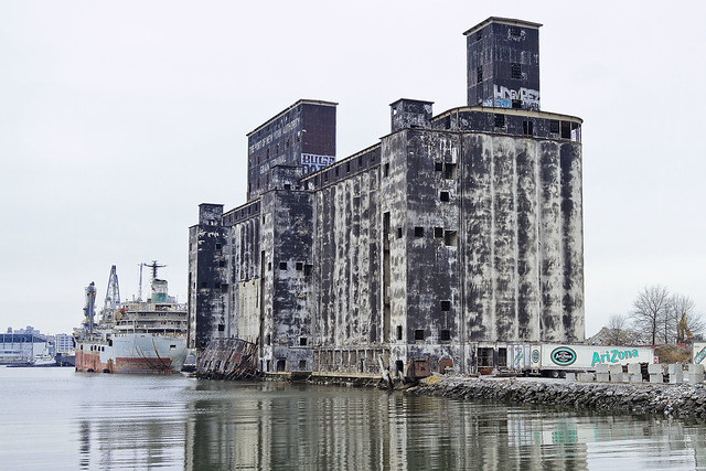
The Gowanus Canal, of which I know little. That’s something I say all the time, and I’m being a bit disingenuous. By the standards of the average person, I know a lot about Gowanus, but not enough to satisfactorily describe it. Recently, I attended a lecture by Joseph Alexiou, and that young man knows about the Gowanus.
The structure pictured above was formerly a grain terminal, by the way.

– photo by Mitch Waxman
Unfortunately, much of the story here at Gowanus is the same as it is on Newtown Creek. Oil companies and chemical factories and manufactured gas plants and centuries of industrial activity, coupled with the City running open sewers directly into the water. Abandon all hope, ye huddled masses.
“follow” me on Twitter- @newtownpentacle


