Archive for the ‘Greenpoint’ Category
sterner things
It’s National Bomb Pop Day, in these United States.

– photo by Mitch Waxman
As described in yesterday’s post, a hurried flight from “Point A” in Astoria to “Point B” in Brooklyn’s Greenpoint section was enacted last Saturday, in order to arrive on time for a walk through and discussion of the NYC DOT’s Kosciuszcko Bridge project’s commitment to create new parkland in the post facto footprint of their construction zone. Invitees were community members, folks from Open Space Alliance, NYC Parks Department, and a few local busybodies such as myself.
That’s Robert Adams, of the New York State Department of Transportation, chief engineer and showrunner for the K Bridge replacement project.

– photo by Mitch Waxman
I’ve stated many times that the community communications side of this project has been extraordinary. I’ve also reported to a number of people that Mr. Adams, in particular, has been remarkably transparent and amiable to receiving input from those who surround the perimeter of his project. Gold standard, in my experience, as far as handling the impact of a large scale public works projects in the crowded urban industrial setting of Newtown Creek in North Brooklyn and Western Queens. Kudos.

– photo by Mitch Waxman
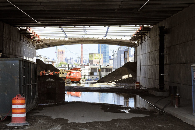
As has become familiar – when visiting the K Bridge job site – our little group donned “Personal Protective Equipment,” which included safety glasses, gloves, orange vests, and hard hats. That paved sidewalk, on the left of the shot above adjoining the retaining wall for the Brooklyn Queens Expressway’s Meeker Avenue onramp, is “used to be Cherry Street.” The street we were walking down, in a northerly direction heading towards Scott Avenue, is nouveau Cherry Street.
– photo by Mitch Waxman
That’s the new overpass at Varick Avenue, looking westwards towards the East River.
Documenting this project has been a long standing project of mine – this 2012 post tells you everything you could want to know about Robert Moses, Fiorella LaGuardia, and the origins of the 1939 model Kosciuszko Bridge. Just before construction started, I swept through both the Brooklyn and Queens sides of Newtown Creek in the area I call “DUKBO” – Down Under the Kosciuszko Bridge Onramp. Here’s a 2014 post, and another, showing what things used to look like on the Brooklyn side, and one dating back to 2010, and from 2012 discussing the Queens side – this. Construction started, and this 2014 post offers a look at things. There’s shots from the water of Newtown Creek, in this June 2015 post, and in this September 2015 post, which shows the bridge support towers rising. Additionally, this post from March of 2016 detailed the action on the Queens side. Most recently, here’s one from May of 2016, and one from June of the same year. Here’s one from August of 2016, the December 2016 one, one from March of 2017 which discusses the demolition of the 1939 bridge.
Most recently – a post showing what I saw during a pre opening walk through in early April of 2017, and the fanfare surrounding the opening of half of the new bridge in April of 2017.

– photo by Mitch Waxman
Just shy of Gardner Avenue, currently a closed off section of the construction site, Mr. Adams began to discuss the perimeter of the new park. It will quite literally be in DUKBO, Down Under the Kosciuszcko Bridge Onramp. The site will occupy a mostly paved area largely shadowed by the two new bridges. Our group discussed the possibility of shade tolerant plants, and or harvesting “gray water” from the highways to feed into planting beds.
The problem with that, as stated by somebody from Parks Dept. was this – shade tolerant plants are seldom salt resistant and that even without harvesting runoff from the BQE’s drains, there’s going to be a considerable amount of road salting during the winter months both above and below the parcel.

– photo by Mitch Waxman
The demolition of the old bridge is going to be occurring shortly, which will play out in two stages. First is the removal of the central truss section, then the “energetic demolition” of the approaches. If the schedule holds true, the second half of the new K Bridge will open in 2020 standing in the footprint of the old one.
That’s when the parks business will begin in earnest. There’s a section on the Maspeth side, on 43rd street, in Queens. Another section is this parcel in Brooklyn, and the old Sgt. Dougherty park on Meeker avenue at Chery Street is going to be redesigned and rebuilt.

– photo by Mitch Waxman
One of the interjections a humble narrator offered, as one who knows this zone intimately enough to refer to it affectionately as the “Poison Cauldron of the Newtown Creek,” involved the intended pathways which people from the surrounding neighborhoods would use to get here. The surrounding areas to the east and south are insanely dangerous, traffic wise, with gargantuan trucks whizzing about and all sorts of blue collar people doing blue collar things. Warehouses, waste transfer stations, truck and bus mechanics… not to mention all of the autos at Meeker Avenue angrily straining to get into the approach lanes for the BQE.
In short, way finding and traffic control.

– photo by Mitch Waxman
About those waste transfer stations… one of the things that makes this particular “cauldron” so “poison” is the tonnage of putrescent – or black bag – garbage transported here daily. This section of DUKBO is covered in quite toxic dust. Harvesting a booger from your nasal cavity after a walk through this section will reveal many things to you about the quality of air and suspended particulates. There’s also the smell.
DUKBO stinks of decay, rot, and hot garbage. On humid days, you will notice swirls of diesel exhaust along with shiny specks of dust hanging in the ether, as illuminated by an odd shaft of light. In short – dust and odor control are essential.
The choice of this area is an extremely challenging one for a park, but given the paucity of parkland in North Brooklyn – beggars can’t be choosers and you have to work with what you’ve been given.

– photo by Mitch Waxman
As far as the construction progress side of things, as mentioned, DOT and their contractor’s efforts are now being focused on the removal of the 1939 era Kosciuszcko Bridge. Up top, traffic has long been rerouted onto the easterly half of the new span, and torch bearing demolitionists have been cutting up small sections of the old bridge. The former walkway and the side railing has been cut up and will be sent off for recycling.

– photo by Mitch Waxman
Above Newtown Creek, but below the BQE, crews are assembling the “strand jacks” which will lower the central truss down to a waiting barge. The steel of the central truss is also meant to be recycled, and will be making a final journey to New Jersey escorted by tugs sometime during the coming month.

– photo by Mitch Waxman
This is the view from Scott Avenue, and the new park will continue down to the bulkheads and will overlook the water, I’m told. There has been some discussion of waterfront access here, as in a place where you’d be able to put a boat in the water, but one hasn’t been a part of that conversation.

– photo by Mitch Waxman
Walking back, as we crossed Gardiner Avenue, I handed off my “PPE” to Mr. Adams and bid the group adieux rather than go all the way back to Meeker and Varick Avenues where we had met up.
I headed down instead to the site of the first Meeker Avenue, or Penny Bridge. Once upon a time there was a swing bridge on Newtown Creek which connected Brooklyn’s Meeker Avenue with Queens’ Review Avenue (and the Penny Bridge LIRR stop). Penny Bridge was demolished in 1939 when the new Meeker Avenue Bridge opened (renamed as Kosciuszcko in 1940) but the masonry on both sides of Newtown Creek are still present.
It was a neat idea, I thought, visiting all three Meeker Avenue Bridges in the same day.
History nerd here, what can I tell ‘ya?

– photo by Mitch Waxman
While I was at Penny Bridge, my zoom lens was dialed to its extant focal length and I zeroed in on the Queens side’s strand jacks being erected. Hey, I may be a history nerd, but I know for a fact that several of you out there are engineering nerds.
Upcoming Tours and events
Newtown Creek, Greenpoint to Hunters Point, walking tour with NYCH2O – June 29th, 7-9 p.m..
Experience and learn the history of the western side of Newtown Creek, as well as the East River Parks Hunters Point with NCA Historian Mitch Waxman – details here.
“follow” me on Twitter- @newtownpentacle
resonant profanity
It’s National Ceviche Day, in these United States.

– photo by Mitch Waxman
“I’m late, I’m late, For a very important date. No time to say “Hello, Goodbye”. I’m late, I’m late, I’m late” is what was going through a humble narrator’s brain box last Saturday morning. Often is Lewis Carroll psychically conjured on my way to Newtown Creek, a place which is the very definition of “through the looking glass” for one such as myself.
Accordingly, a vehicular coach was summoned via the LYFT application found on my pocket telecommunications device, which automotively conveyed one to the poison cauldron of the Newtown Creek in Greenpoint. The driver, following the directions offered by a computer program on his own pocket telecommunications terminal, used the Brooklyn Queens Expressway for the trip. For once, rolling the dice on the BQE paid off and it was a quick journey between “Point A” in Astoria and “Point B” in Brooklyn.

– photo by Mitch Waxman
We crossed the lugubrious Newtown Creek on the sparkling new 2017 model Kosciuszcko Bridge, with the 1939 version just to the west. As one such as myself cannot turn down an opportunity to record and catalog any and all visual experiences encountered in the City of Greater New York, the camera was being waved around in the back seat as the driver performed his particular function in the front.

– photo by Mitch Waxman
The NYS DOT is currently working on the dismantling of the 1939 version, which is at an early stage. Newtown Creek Alliance has recently prepared and propagated a post describing what we know about the various stages, scheduling, and status of the demolition project for the so called “K Bridge,” and it can be accessed here.

– photo by Mitch Waxman
You may recall that I was up here for opening day of the new bridge back in April, but that was on foot. Dedicated pedestrian that I am, it’s an odd thing to actually be riding in an “auto-mobile,” but since I had experienced a fairly late night the evening before – one had risen later than planned and there was no way that I was going to get to Brooklyn from Astoria on time via perambulatory means.
I’m actually obsessed with being “on time” and am particularly keen on “being early” for events and meetings. It’s kind of a “thing” with me. My parents always insisted that you arrive early to appointments, as that’s at least one thing that the people you’re going to see can’t hold against you. Mom always said “you can’t do anything about being ugly, stupid, ungrateful, and unlikeable but at least you can be early.” I’m all ‘effed up.

– photo by Mitch Waxman
This wasn’t a tour, per se, as in one I was conducting of the area which I’ve long referred to as “DUKBO” or Down Under the Kosciuszcko Bridge Onramp.” Instead, the NYS DOT is in the early stages of planning two parks – one in Queens and one here in Brooklyn. They called together members of the K Bridge Stakeholders Advisory Committee (I’m on that one) and the Brooklyn Parks group “Open Space Alliance,” or OSA, to discuss the space and begin the process of planning.
I showed up wearing my Newtown Creek Alliance hat, but since we were going to enter the job site, it was soon replaced by a hard hat that said “Skanska.”
– photo by Mitch Waxman
My LYFT driver was instructed by both myself and the computer program on his pocket computer terminal to exit the BQE at the Meeker avenue stop, which was terribly exciting for one such as myself as I’m a “creek geek.”
Kept on thinking about that white rabbit, me. It was nearly the time for the meetup with DOT and OSA, and I’d still have to walk a block or two to the location.

– photo by Mitch Waxman
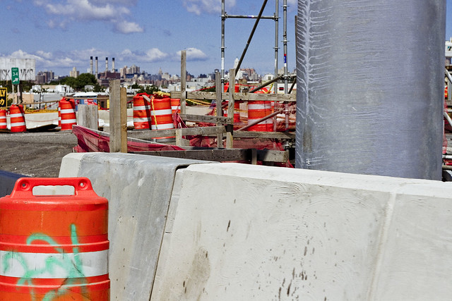
That’s the east side of Meeker Avenue pictured above, with its newly constructed on-ramps and approach roadways feeding traffic from Brooklyn into Queens. It’s been so chaotic in this area for the last few years, what with the construction and all, that it was quite a relief to see a bit of calm inserted back into DUKBO.

– photo by Mitch Waxman
Saying that, there was still quite a hullabaloo going on in DUKBO.
The demolition of the 1939 bridge will be the supreme focus of all the concerned parties for the next several months, but for right now the teams of contractors and union hard hats are making busy with repaving local roads and improving the subterranean infrastructure (sewers, drains etc.) that serve the new bridge. I know the folks who live in the house that that backhoe is working in front of, who are… shall we just say… anxious for the project to conclude.
Tomorrow, I’ll show you what I saw whilst wearing the hard hat in DUKBO.
Upcoming Tours and events
Newtown Creek, Greenpoint to Hunters Point, walking tour with NYCH2O – June 29th, 7-9 p.m..
Experience and learn the history of the western side of Newtown Creek, as well as the East River Parks Hunters Point with NCA Historian Mitch Waxman – details here.
“follow” me on Twitter- @newtownpentacle
collective deliberation
It’s National Onion Ring Day, in these United States.

– photo by Mitch Waxman
A few odds and ends greet you today, lords and ladies. Pictured above is my beloved Newtown Creek, as seen from a bulkhead in Greenpoint. That barge is being filled with aggregate soil material by the Allocco recycling operation on Kingsland Avenue. Aggregates are an interesting side of the recycling industry, wherein excavated soil is sieved and graded according to particle size (gravel, sand etc.) and then sold in bulk for industrial “fill,” or packaged and sold at consumer hardware stores in fifty pound bags. It diverts the stuff from ending up in landfills. Who knew?

– photo by Mitch Waxman
A humble narrator was on his way out one fine afternoon, and caught this meteorological sight. A curtain of rain was trailing a storm cloud, on an otherwise sunny day, as the cell headed eastwards. For some reason, I’m fascinated by this sort of thing, but I also routinely throw rocks at the moon when it rises outside of my cave.

– photo by Mitch Waxman
The weather down in the rotting concrete bunkers and tunnels of the Subway system never ceases to amaze me. Given that it’s a series of shaft ways open on both ends and which are open to the air at nearly every station, and have de facto pistons moving through them at somewhat regular intervals, how and why is it that the atmospherics in subway stations always seem to lag twenty four to forty eight hours behind the surface? Also, why is it also so damned hot at 34th street/Herald Square?
I avoid that station like the freaking plague because of the heat.
Upcoming Tours and events
Newtown Creek, Greenpoint to Hunters Point, walking tour with NYCH2O – June 29th, 7-9 p.m..
Experience and learn the history of the western side of Newtown Creek, as well as the East River Parks Hunters Point with NCA Historian Mitch Waxman – details here.
“follow” me on Twitter- @newtownpentacle
odd purchases
It’s National Martini Day, in these United States.

– photo by Mitch Waxman
One of the things that we, as in the environmental and activist community along Newtown Creek, have been asking officialdom about for years is about why there is zero signage advising the citizenry about not fishing or crabbing in the Newtown Creek. I know this might strike you as odd, but folks actually do fish and crab hereabouts. Observationally, these are people who were born overseas, so the signage issue becomes a bit complicated given the legendary “diversity” of Western Queens and North Brooklyn. The Albany people have always questioned as to why you’d need signage, as it’s illegal to fish without a license, and every NYS licensee has been advised about the environmental conditions encountered on the inland waterways of NYC – which is one of the most “Albany people” things I’ve ever heard.
Luckily, the Feds at EPA realized what we’ve been asking for is necessary and have begun the process of creating advisory signage, and the PRP (Potentially Resonsible Parties) consortium which styles itself as the “Newtown Creek Group” volunteered to manufacture the placards, which EPA would in turn design and install. The signage is pretty close to its final design iteration, and the latest version looks like this. As to where the signs should be placed? Who has carefully documented every little pocket and corner of the streets surrounding the Creek? Who can tell you where people commonly fish? That’s a Newtown Creek Alliance job, anyone can tell you that.
Let’s face it, who ya gonna call?

– photo by Mitch Waxman
Accordingly, one found himself in Greenpoint recently at nine in the morning as the EPA team assembled. Civilians cannot ride in Government vehicles (which is an odd rule, as we technically own them) so the third party contractor who will do the actual installation of the things did the driving. We hit every little corner of the Newtown Creek where people can find access to the water, even the hidden spots where the “utes” of Greenpernt like to experiment with cannibinoids.
It was actually quite a beautiful morning, and the light was fantastic, so while the Feds got busy with the tape measures and GPS’d the various locations we visited, I waved the camera around a bit.

– photo by Mitch Waxman
We did encounter an “enforcement situation” in Brooklyn alongside the Metropolitan Avenue Bridge. There’s a protocol for “who’s responsible for what” along the Newtown Creek. Short version is this – EPA is in charge of Superfund, which is specifically related to the sediments under the water. New or ongoing pollution entering the water is the provence of the NYS Department of Environmental Conservation.
The NYC DEP is responsible for absolutely nothing anywhere or anytime, it’s not their fault at all, and they have no idea why they were named as a PRP in the first place as it’s all Exxon or National Grid’s fault.
The fellow from EPA I was on the bridge with confirmed my belief that “I should call this in” and the NYS DEC Spill Response hotline was called. If you spot oil slicks, plumes of floatable contaminants, or as in the case of the shot above – hundreds of gallons of milky white mystery juice exiting one of DEP’s open sewers – the protocol is to first photograph it, as documentation, and then to call 1 (800) 457-7362 to let DEC know about the situation so they can investigate.

– photo by Mitch Waxman
We were, as mentioned above, visiting every conceivable spot that the citizenry could find their way to the water.
That included “off limits” locations like the Montrose Avenue Rail Bridge over the English Kills tributary. As you can see from all the interesting graffiti on the bridge, which carries lead tracks of the Bushwick Branch LIRR, trespassing is pretty common back here. This is the reason that EPA asked Newtown Creek Alliance to send somebody along with them, as there’s the “official story” and a “real story” found along the water.

– photo by Mitch Waxman
This family of Canada Geese were encountered at the Maspeth Avenue Plank Road, and were being predated by a feral cat who was anxious for breakfast. Momma and Poppa Goose were just out of frame to the left, so the cat made a brilliant decision and continued on into the brush to look for some easier prey. We encountered a couple of broods of Geese over the course of the morning. Geese can be ornery, as a note, and will smack you up if they’re annoyed.
One of these illegal alien avian bullies, at Maspeth Creek, actually hissed at us as we neared, and stuck its tongue out at me.

– photo by Mitch Waxman
The reasoning behind the signage is based around science rather than good humored politics, incidentally. When you’re chatting with environmental officials, they don’t refer to oysters or mussels as shellfish, rather they call them “bioaccumulators.” Animals that are high up in the food chain have internal organs – livers in particular – and muscular tissues which have amassed dangerous levels of whatever pollutant is found in the sediments of the waterway, which they’ve attained by consuming all the prey critters who are below them in the food chain hierarchy. In the case of crabs, in particular, you can encounter a fantastic amount of chemical concentrates due to their particular niche and occupations.
Newtown Creek is – of course – a Federal Superfund site. The sediment beds hereabout are a goulash of petroleum and petroleum byproducts, organocopper compounds, volatile organic compounds, PCB’s, coal tar, sewage, and everything else that has ever been dumped or spilled into the water. The sediment is referred to as “black mayonnaise” and it’s where the crabs live. It’s also where most of the invertebrates that form the bottom of the food chain for the fish population live. Itty bitty critters eat the decaying organics of the black mayonnaise, and slightly less itty bitty critters eat handfuls of the little guys, and the larger critters eat hundreds of them – you get the idea.
You don’t want to eat fish or crabs that you catch in the Newtown Creek. Really.
Upcoming Tours and events
Newtown Creek, Greenpoint to Hunters Point, walking tour with NYCH2O – June 29th, 7-9 p.m..
Experience and learn the history of the western side of Newtown Creek, as well as the East River Parks Hunters Point with NCA Historian Mitch Waxman – details here.
“follow” me on Twitter- @newtownpentacle
indelibly inked
It’s National Rotisserie Chicken Day, in these United States.

– photo by Mitch Waxman
The new green roof at Broadway Stages’ 520 Kingsland Avenue building was recently made available to me for a couple of hours by the folks who installed and created the place – Alive Structures – in pursuance of creating a portfolio of photographs for brochure and website purposes. This is also a Newtown Creek Alliance project btw, and I packed up the “full kit,” including tripod and cable shutter release, in anticipation of getting both “artsy” and “fartsy.” It ain’t that often that I get to do the full set up for “proper” landscape style shots.
As always, I went well beyond my shot list, and figured that I’d show off a little bit in today’s post. That’s the Newtown Creek Wastewater Treatment Plant in the shot above, with the camera looking through the invisible methane flames that the DEP is burning off towards lower Manhattan.

– photo by Mitch Waxman
Looking across Newtown Creek towards Long Island City – you can see the Long Island Expressway truss bridge rising some 106 feet above its tributary, Dutch Kills, but it’s been completely overshadowed by the titan slabs of mirror glass rising along Jackson Avenue between Court Square and Queens Plaza.
The truss dates back to Robert Moses and 1939, btw, and its height was dictated by the needs of the maritime and industrial powers who used to rule the roost in LIC.

– photo by Mitch Waxman
Looking eastwards, towards the two Koscisuzcko Bridges (1939 and 2017 models), and over the petroleum tanks of Metro Fuel. The Greenpoint Avenue Bridge is just on the other side of these tanks, but occluded by them in this shot. At the extreme left of the photo is the tree line of Calvary Cemetery in Queens’ Blissville section.
Nothing like getting high along Newtown Creek, I always say.

– photo by Mitch Waxman
For those of you who saw me looking particularly sun burnt in middle May, these shots are the reason why. I spent something like two and change hours up on the roof at 520 Kingsland Avenue, mainly waiting for the burning thermonuclear eye of God itself to dip behind the Shining City and make the shot above possible.
If you’d like to take a look at 520 Kinsgland for yourself, NCA and Riverkeeper will be conducting a “community visioning” project there tomorrow between one and four, and then between five and seven I’ll be offering a history lecture and green roof tour of the space… come with? It’s all free, and the RSVP details are in the links below.
Upcoming Tours and events
Newtown Creek Alliance and Riverkeeper Visioning, June 3rd, 1-4 p.m..
Imagine the future of Newtown Creek with Riverkeeper and NCA at the Kingsland Wildfowers Green Roof (520 Kingsland Avenue in Greenpoint) – details here.
Newtown Creek Alliance History lecture with NCA historian Mitch Waxman, June 3rd, 5:00- 7:30 p.m.
An free hour long lecture and slideshow about Newtown Creek’s incredible history at the gorgeous Kingsland Wildfowers Green Roof (520 Kingsland Avenue in Greenpoint) followed by a walk around the roof and a Q&A – details here.
Green Drinks Queens LIC, June 5th, 6:00- 9:00 p.m.
Come celebrate UN World Environment Day with Green Drinks: Queens on the LIC Waterfront! This year’s theme is “Connecting People With Nature.” – details here.
“follow” me on Twitter- @newtownpentacle


