Archive for the ‘Greenpoint’ Category
quite convinced
– photo by Mitch Waxman
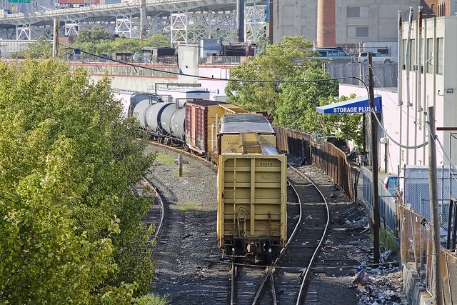
Recent financial setbacks and personal problems infect your humble narrator with a form of deep melancholy and a vast ennui. When such moments come upon me, there is a certain pizzeria in Greenpoint (Norman corner of Manhattan, near the train) whose offerings can be summed up best as: an actual and old fashioned “Brooklyn Slice”. On the day I spied this collection of rail cars at the so called “Bliss Tower” in DUGABO, I had scuttled forth from the rolling hillocks of my beloved Astoria in pursuit of one of these aforementioned slices, in an effort designed to brighten my mood.

– photo by Mitch Waxman
Errors and omissions mar my record when discussing the Rails, much to the chagrin of the knowledgable railfan community (whose helpful comments and corrections are always appreciated here at Newtown Pentacle). As such, what I can categorically tell you is that this a New York & Atlantic Locomotive, one of the 11 engine units which service the 269 miles of track operated upon by the Glendale based company in Brooklyn, Queens, and both Nassau and Suffolk counties. It shares much of its road with the passenger based Long Island Railroad, and NY&A’s distinctive emerald, white, and black engines are regularly observed around the Newtown Creek.

– photo by Mitch Waxman
Across the Newtown Creek Watershed, one encounters a landscape built for rail. Long abandoned track beds lie buried in inches of road asphalt, pointing the way to industrial giants long absent. Train stops orphaned from their purpose, spars and switches which were rudely severed to make room for modernity. All of it operated at street grade, and the remnants of the iron road are often the only tangible remains of great concerns and financial largesse. If you follow the right spar, you’ll discover that the NYPD Barricades unit was once Thypin Steel, or that LaGuardia Community College was once the Loose Wiles bakery and part of the Degnon Terminal.

– photo by Mitch Waxman
Within the communities which surround the Newtown Creek, a complaint often repeated concerns the presence of large numbers of trucks utilizing local streets in their quest to move goods from A to B. I had the privilege last year of attending a presentation by certain factions within the Port Authority that described a proposal which would eliminate several thousand truck trips a day throughout the City and over the George Washington Bridge, simply by shipping New York City’s garbage out to land fill utilizing locomotive rather than automotive means. Calculations about air pollution, road maintenance costs, and vehicular accident rates were presented at the time which compared rail quite favorably with truck based shipping.There was a maritime component to the plan as well, which was a bit hazy, but the train concept was spun gold.

– photo by Mitch Waxman
The shot above represents an NY&A Locomotive making a drop off of a customer in Maspeth near the ill fated St. Saviour’s church site, where they will uncouple a car or two for the unloading or loading of certain cargo. An unthinkable amount of trucks would be required to carry the same tonnage. The subject of Green Technology and “Greening New York” is often bandied about by many these days. Too much of the conversation, however, is “cocktail party environmentalism”- which sounds great but just isn’t practical on a policy level.
I’ve developed this funny notion, however, that the way forward is actually to re-imagine and re-invent the heaviest industry of them all.

– photo by Mitch Waxman
Rail infrastructure is what made Long Island City the factory of not just New York, but the entire world at the turn of the last century and multiple generations of capitalists and real estate interests founded vast fortunes because of the initial investment in it. Newtown Creek was the busiest waterway in North America, carrying more ship and barge traffic than the entire Mississippi for a time, and all of that maritime activity was fed by rail. Intermodal rail floats actually carried whole trains across the harbor to Manhattan, Staten Island, New Jersey and beyond. Imagine the benefits, in both individual wealth and environmental health, were we to try and save the future by looking for solutions in the past.
I’m still kind of forming this idea up for myself, but the key to it is containerization. More on this soon.
What do you, lords and ladies, think on the subject? Use the comments “Reply box” below, if you would like to start a conversation about it.
puerile symbolism

– photo by Mitch Waxman
It’s difficult for me to not interpret what I found on my camera card for this leg of my “Grand Walk”, a panic induced fugue through starry pathways which carried me from St. Patrick’s Old Cathedral in Manhattan back to Astoria, as not being influenced by street car lines which haven’t existed since the early 20th century. These streets are relict, not that important anymore, and have served Brooklynites simply as short cuts to the bridge for quite some time. The BQE served to silence and humiliate Williamsburg mid century and nearly destroyed the place.
from the Brooklyn daily eagle almanac, courtesy google books

– photo by Mitch Waxman
By diverting traffic around Williamsburg, just as the Long Island Expressway does in the “Empty Corridor” of Long Island City, the local streets are starved of the economic benefits they once enjoyed from the Manhattan bound traffic. When still a child, the family would pack into the Plymouth periodically and head to north Brooklyn for so called “Italian cookies”. The trip was justified by the existence of relict bakeries in the area which hadn’t changed their menus in decades as no new customers were appearing.
The entire coast line of Long Island that faces the East River spent most of the 20th century asphyxiating in this manner and one man in particular is responsible for it.
from wikipedia
Robert Moses’s power increased after World War II, when, after the retirement of LaGuardia, a series of politically weak mayors consented to almost all of Moses’s proposals.Named city “construction coordinator”, in 1946, by Mayor William O’Dwyer, Moses also became the official representative of New York City in Washington, D.C. Moses was also now given powers over public housing that had eluded him under LaGuardia. Moses’s power grew even more when O’Dwyer was forced to resign in disgrace and was succeeded by Vincent R. Impellitteri, who was more than content to allow Moses to exercise control over infrastructure projects from behind the scenes.
One of Moses’s first steps after Impellitteri took office was killing the development of a city-wide Comprehensive Zoning Plan, underway since 1938, that would have restrained his nearly uninhibited power to build within the city, and removing the existing Zoning Commissioner from power. Impellitteri enabled Moses in other ways, too. Moses was now the sole person authorized to negotiate in Washington for New York City projects. He could now remake New York for the automobile. By 1959, Moses had built 28,000 apartment units on hundreds of acres. In clearing the land for high-rises in accordance with the tower in a park scheme, which at that time was seen as innovative and beneficial, he sometimes destroyed almost as many housing units as he built.
From the 1930s to the 1960s, Robert Moses was responsible for the construction of the Throgs Neck, the Bronx-Whitestone, the Henry Hudson, and the Verrazano Narrows bridges. His other projects included the Brooklyn-Queens Expressway, the Staten Island Expressway, the Cross-Bronx Expressway, the Belt Parkway, the Laurelton Parkway, and many more. Federal interest had shifted from parkway to freeway systems, and the new roads mostly conformed to the new vision, lacking the landscaping or the commercial traffic restrictions of the pre-war ones. He was the mover behind Shea Stadium and Lincoln Center, and contributed to the United Nations headquarters.

– photo by Mitch Waxman
As is the case in cities across the world, when the rents went down, crime went up. In modernity, while New York City was experiencing a serious decline in crime statistics – Nassau County and Newark experienced an explosion of illicit activity. This is a largely uncommented phenomena, of course, as the lowering of crime in NYC is largely attributed to the NYPD rather than a socioeconomic migration of problematic populations from one part of the megalopolis to another. The same is true of the “gentrified” sections of Brooklyn and Queens, when crime dropped in Long Island City- it rose in Jamaica.
Why? The rent is cheaper in Jamaica than it is in Tower Town.
from wikipedia
New York became the most populous urbanized area in the world in early 1920s, overtaking London, and the metropolitan area surpassed the 10 million mark in early 1930s, becoming the first megacity in human history. The difficult years of the Great Depression saw the election of reformer Fiorello LaGuardia as mayor and the fall of Tammany Hall after eighty years of political dominance.
Returning World War II veterans created a postwar economic boom and the development of large housing tracts in eastern Queens. New York emerged from the war unscathed as the leading city of the world, with Wall Street leading America’s place as the world’s dominant economic power. The United Nations Headquarters (completed in 1950) emphasized New York’s political influence, and the rise of abstract expressionism in the city precipitated New York’s displacement of Paris as the center of the art world.
In the 1960s, New York City began to suffer from economic problems and rising crime rates. While a resurgence in the financial industry greatly improved the city’s economic health in the 1980s, New York’s crime rate continued a steep uphill climb through the decade and into the beginning of the 1990s.[83] By the 1990s, crime rates started to drop dramatically due to increased police presence and gentrification, and many American transplants and waves of new immigrants arrived from Asia and Latin America. Important new sectors, such as Silicon Alley, emerged in the city’s economy and New York’s population reached an all-time high in the 2000 census.

– photo by Mitch Waxman
What fascinates, however, are the lost connections between the ancient villages and once upon a time cities of this original gold coast found along the River of Sound. Manhattan avenue, looking off in the direction of Greenpoint is pictured above. The street car lines which shuttled shoppers and commuters from the Grand Street Ferry back to Newtown Creek’s greatest city ran along here, and would have turned off Grand north toward Greenpoint and Long Island City via the Vernon Avenue Bridge.

– photo by Mitch Waxman
Another line would break off at Bushwick Avenue, carrying passengers south and east. Ultimately, a rider could travel all the way to Canarsie from here. Mention must be made that I’m no expert on the topic of street car lines in Brooklyn, and that the subject has only recently gained any paramount in my researches on the history and underlying structure of this- your Newtown Pentacle.
Which brings me to something I get asked a lot these days- what exactly do you mean by “Newtown Pentacle”?

– photo by Mitch Waxman
The European mind of the 17th, 18th, and early 19th century delighted in geometry and esoteric symbolism. Famously, Christopher Wren laid London’s churches and palaces out in a colossal pentagram when rebuilding from the Great Fire of London in 1666. Certainly, defensive fortifications and strategic thinking in these ages followed certain long standing geometries- stars and pentagrams especially. Washington D.C. Fulfills some freemasonic ideal of urban planning, with White House and Capitol Building occupying particular location and relationship to obelisk and parade grounds. Western Queens and North Brooklyn are no exception to this rule.
from wikipedia
Little also is known of Wren’s schooling. The story that he was at Westminster School from 1641 to 1646 is unsubstantiated. Parentalia, the biography compiled by his son, a third Christopher, places him there “for some short time” before going to Oxford (in 1650). Some of his youthful exercises preserved or recorded (though few are datable) showed that he received a thorough grounding in Latin; he also learned to draw. According to Parentalia, he was “initiated” in the principles of mathematics by Dr William Holder, who married Wren’s elder sister Susan (or Susanna) in 1643. During this time period, Wren manifested an interest in the design and construction of mechanical instruments. It was probably through Holder that Wren met Sir Charles Scarburgh whom Wren assisted in his anatomical studies.
On 25 June 1650, Wren entered Wadham College, Oxford where he studied Latin and the works of Aristotle. It is anachronistic to imagine that he received scientific training in the modern sense. However, Wren became closely associated with John Wilkins, who served as warden in Wadham. Wilkins was a member of a group of distinguished scholars. This group, whose activities led to the formation of the Royal Society, consisted of a number of distinguished mathematicians, original and sometimes brilliant practical workers and experimental philosophers. This connection probably influenced Wren’s studies of science and mathematics at college. He graduated B.A. in 1651, and three years later received M.A.

– photo by Mitch Waxman
Start a line at the Williamsburg Bridge, or let’s just call it the Wallabout. Trace it to Broadway’s intersection with Jamaica Avenue, and follow the Interboro (Jackie Robinson Parkway) to the remains of Flushing Creek at the Grand Central. Follow Grand Central north, past Strong’s Causeway, to the extant of historic Newtown in Elmhurst at “North Beach” which is modern day LaGuardia airport. Trace the line west along the original coastline of Queens to Hells Gate, and then south back to the Wallabout. This area encapsulates the entire colonial network of roads and villages which grew up isolated from the rest of the island by the Cripplebush of Brooklyn and other natural obstacles like the Flushing River, Newtown and Sunswick and Wallabout Creeks, and which developed into three of the four great municipalities of Long Island’s western coast- Greenpoint, Long Island City, and Williamsburg.
The 4th was the actual city of Brooklyn, of course, but that’s another story.
Pictured above is Morgan Avenue, where another street car would break from the Grand Street line to carry workers to the mills and factories of English Kills in the 3rd ward of Williamsburg, known to modernity as East Williamsburg. God’s gift to pain is found in this direction, and this image signals that my unremembered and unconscious walk had carried me to the Creeklands.

– photo by Mitch Waxman
The colour is noticed here, the iridescent sheen which is neither black nor white nor describable by use of any wholesome Pantone swatch. The prismatic coating which adorns every rusted fencepost and worm eaten piece of wood and the sinister faces of oddly hostile children is like nothing of this earth, rather it is like something from beyond- like a colour from space. A manifestation of dissolution and decay, this colour signals that the Newtown Creek flows lugubriously nearby.

– photo by Mitch Waxman
In this place, where Grand Street meets Metropolitan, another rail car would slip off the main line and head toward Ridgewood, while the Grand Street line would continue toward Maspeth and eventually the center of Newtown itself- crossing the creek via the Meeker Avenue, or Penny, bridge for the electric cars and Grand Street Bridge for the horse drawn.
In this place, what looks like sand is powdered automotive glass, that which appears to wholesome soil is congealed soot and ash, and the very air you breathe is a poisonous fume. Unknown aerosols drift from open sewer and automotive tailpipe mixing freely in a petrochemical haze as the burning thermonuclear eye of god itself stares down on the concrete desolation. Its emanations causes these humors and industrial liquors to combine chemically in unknown and unstudied ways- depositing more of the colour as they precipitate onto every available surface.

– photo by Mitch Waxman
It wasn’t until I saw these images on my camera card that realization set in as to where my panic induced perambulation was headed, and that I hadn’t been following trolley routes or anything normal like that. There was only one place I could be going along this route, one that millions had followed in the 19th century, a journey that started at St. Patrick’s Old Cathedral on the Lower East Side of Manhattan, crossed the River, and continued up Grand Street to it’s final destination in Queens.
For now, though, I seem to have wandered into DUMABO.
from nyc.gov
Metropolitan Avenue Bridge Over English Kills
Metropolitan Avenue is a two-way local City street in Kings and Queens Counties. The number of lanes varies from two to four along the entire length of Metropolitan Avenue, which runs east-west and extends from River Street in the Southside section of Brooklyn to Jamaica Avenue in Queens. The bridge, the only one over English Kills, carries both Metropolitan Avenue and Grand Street. The bridge is situated between Vandervoort and Varick Avenues in the East Williamsburg section of Brooklyn. The Metropolitan Avenue Bridge is a double leaf bascule bridge with a span of 33.8 m. The general appearance of the bridge has been significantly changed since it was opened in 1931. The bridge provides a channel with a horizontal clearance of 26.2 m and a vertical clearance, in the closed position, of 3.0 m at MHW and 4.6 m at MLW. The bridge structure carries a four-lane two-way vehicular roadway with sidewalks on either side. The roadway width is 16.2 m and the sidewalks are 1.8 m. There are no height restrictions on the bridge.
After the City acquired Metropolitan Avenue from the Williamsburg and Jamaica Turnpike Road Company in 1872, the existing bridge was replaced by a swing bridge, which was also used by the Broadway Ferry and Metropolitan Avenue Railroad Company. Growth in the area made the bridge inadequate by the early 20th century. The current bridge was built in 1931. Modifications since then have included upgrading the mechanical and electrical systems and the replacement of deck, bridge rail, and fenders. The stringers were replaced and new stiffeners added in 1992.
athwart the desert

– photo by Mitch Waxman
Many things find a piquant and interested perch in my thoughts.
Autocthonic, these wonderings are often based on observations of a block or two of grandiose structures which seem out of place in modern context, Greenpoint Avenue between Manhattan Ave. and the East River is just one.
There is a distinct and obviously missing element which once defined its “reason for being”, and like many of the other occlusions which abound along the coastline of North Brooklyn and Western Queens- the answer is presented by First Calvary Cemetery.
from the “DIGEST OF SPECIAL STATUTES By THE CITY OF NEW YORK” courtesy google books
1865: This act incorporates the Green Point and Calvary Railroad Company, and authorizes the construction of a railroad, to be operated by horse power only, from at or near the Green Point and Tenth street ferry, at the foot of Green Point avenue, in the city of Brooklyn, thence along Green Point avenue to Green Point avenue plank road, across the bridge over Newtown creek; thence easterly along said road to the easterly side of Calvary cemetery at or near the point where the, said road intersects the main road leading from Calvary cemetery to Hunter’s Point; thence to Central avenue; thence along Central avenue and Commercial street to Franklin avenue, to Freeman street, to Washington street, to the place of beginning.

– photo by Mitch Waxman
It’s no accident that Almiralls chapel is clearly visible from the paramount of Greenpoint Avenue at Manhattan Avenue.
It’s a latecomer to the scene of course, having been built in the early years of the 20th century, but in 1865 when the Streetcar Line described above was mandated there were 1,000 interments a day going on at Calvary. Some portion of those were the graves which were being uprooted over in Manhattan of course, when cemeteries there were outlawed by the Rural Cemetery Act of 1848, but the majority of the dead coming to Queens were from a sausage grinder called the Five Points and the Tenth Street Ferry was how you got from points A to B for the funerals.
from “A history of the city of Brooklyn By Henry Reed Stiles” courtesy google books
The Green-point Ferries are from the foot of Green-Point Avenue, Brooklyn, E. D., to the foot of East Tenth and East Twenty-Third streets, New York. The first named route was established in 1852 (lease dated 1850), by the efforts of Mr. Neziah Bliss, of Green-Point; and was soon transferred to Mr. Shepard Knapp, being now held by G. Lee Knapp. The Twenty-Third street route was established in 1857, and held by St. Patrick’s Cathedral, per G. Lee Knapp. Rent of the Tenth street ferry, $1,300, and of the Twenty-Third street, $600 per annum, both expiring in 1874.

– photo by Mitch Waxman
It’s not the facts of the Ferry or Streetcar that make me curious, of course.
What I’ve been wondering about lately is how the ethnic neighborhoods in the boroughs came to be. Everybody started in Manhattan on the Lower East Side, yet the Jews of Bayard Street and the Italians of Mulberry found a path to Williamsburg and Greenpoint (Tenth Street Ferry?), while the Catholic Germans found their way to Ridgewood and Astoria (86th Street Ferry?). The Irish were everywhere, but made colonies of Woodside and Rockaway.
What natural synergies drew large populations of ethnic brethren to these neighborhoods?
Work was certainly a factor (garment and stone industries in the industrial mills of Newtown Creek and Williamsburg, etc.), but I’m wondering if it wasn’t the lost Ferry and Streetcar connections which allowed and encouraged these ethnic populations to agglutinate.
from “The Sun’s guide to New York” in 1892 courtesy google books
Tenth Street Ferry Branch (color cream): Runs from foot Chambers St., cor. West (ferry to Pavonia Ave., Jersey City and Erie R. R. Depot), through West to Charlton, to Prince, to Bowery, to Pitt St., to Ave. C, to foot E. 10th St. (Tenth St. Ferry to Greenpoint Ave., Brooklyn), returning by E. 10th St., to Ave. D, to E. llth St., to Ave. C, to E. 3d St., to 1st Ave., to Houston St., to West, to Chambers, cor. West.
June 6th, Magic Lantern Show at Greater Astoria Historical Society

Metropolitan Avenue Bridge, English Kills – photo by Mitch Waxman
I’ve neglected to inform you all of the Magic Lantern Show which this, your Newtown Pentacle, is staging at the Greater Astoria Historical Society on Monday, June 6th at 7pm. There won’t be any archaic museum pieces in use, of course- my magic lantern is all digital and uses a standard and quite modern projector- but the concept is much the same. A photographer captures some hellish reality from the wild and shadowed corners of the world, and presents them with the intention of revealing hidden truths to a comfortable and otherwise wholesome audience who would never encounter this reality otherwise.
from a Newtown Pentacle post of April 13th, 2011
Just under an hour long, this Magic Lantern Show about Newtown Creek is personally narrated, and transports the viewer to every corner of the Newtown Creek- every tributary and street end, on the water and above it, and is presented in the idiosyncratic and off beat manner which has become familiar to regular readers of this- your Newtown Pentacle. It attempts to explain certain core questions in under an hour which have been repeatedly presented to me over the last couple of years, and the entire talk is illustrated with both my own photography and the product of my historical research:
- What exactly do you mean by the “Newtown Pentacle”?
- When did the Newtown Creek begin to matter?
- Why should I care, how does the Newtown Creek affect me, as I live in Manhattan?
- Where exactly is this place?
- Who is responsible for this mess, and exactly who is it that’s going to clean it up?
- How can I get involved and help my community revitalize and or restore the Newtown Creek?

Empire State Building rising over industrial Brooklyn and Newtown Creek – photo by Mitch Waxman
It would probably be “politique” to mention that this is not a Newtown Creek Alliance event, which is one of the many organizations which I’ve become affiliated and identified with. Instead this is purely a Newtown Pentacle show, which the studied philosophs who inhabit the upper echelons of the Greater Astoria Historical Society are allowing me to present in their convenient location on Astoria’s Broadway- stumbling distance from the R,M, and N trains. The efficacy of gambling their precious time and effort upon such a poor specimen as myself would be proven by the event being well attended, and the negligible $5 fee at the door should prove an easy burden for most to bear. Therefore, a narrator humbly invites and requests your support and attendance.
from astorialic.org
Mon Jun 6, 7:00 pm
Travel the length and breadth of Americas most polluted waterway, the Newtown Creek, with newtownpentacle.com‘s Mitch Waxman.
Breathtaking photography illustrates the journey, exploring the various tributaries and discussing the industrial history of New York City‘s least known waterway.
Witty and irreverent, the narration describes Waxman‘s own discovery of this place and the fantastic journey it has taken him on.
Question and Answer period follows.

DUKBO, Down Under the Kosciuszko Bridge Onramp – photo by Mitch Waxman
The actual presentation is just over a hour long, and during it, you’ll travel the length and breadth of the Newtown Creek- every tributary and bridge, each keystone of historical import will be illustrated with both personal experience and historical meaning. For those of you new to the story of the Newtown Creek (or the neighborhood) this will make a fine primer. Attempts will be made by your humble narrator to reveal this willfully hidden place, and introduce the uninitiated to the hellish flames of revelation which only the Newtown Creek can offer.

Greenpoint Avenue Bridge over Newtown Creek – photo by Mitch Waxman
The places I go, the things I see… often strain credulity. This is not the world you know, this 3.8 mile long waterway located directly across the East River from Manhattan’s Bellevue Psychiatric Hospital which provides the currently undefended border of Brooklyn and Queens. If it can happen, it has happened here, and if it happened here it happened worse and grander than anywhere else it ever happened. Come visit the night soil and offal dock, hear the stories of the great men- Bliss and Kingsland and Flowers and Degnon and Cooper. This is the place where the Industrial Revolution actually happened, where the death of nature itself was accomplished, and our modern world was born.
Welcome to the Newtown Creek, poison heart of the Newtown Pentacle…
DEP events at Newtown Creek Waste Water Treatment Plant
Everybody’s friends at the DEP have asked if I could share these invites to upcoming public events with you, Lords and Ladies of the Pentacle.
I’ll be busy on the 21st of course, but will make sure that everyone onboard waves when we’re passing by on the boat.


Lastly:
It is critical for you to purchase tickets for the Newtown Creek Cruise soon. We’re filling up rapidly and seating is limited. Your humble narrator is acting as chairman for this journey, and spectacular guest speakers are enlisted to be onboard. Click here to order tickets. Something I can promise you, given the heavy rain we’re having at the beginning of this week, is that the Newtown Creek will be especially photogenic on Saturday. Current forecasts call for light fog, possible early morning showers (we leave the dock at 10- late morning) and clouds clearing around noon! Photographers in Greenpoint, Long Island City, and beyond- this is going to be hyperfocal MAGIC.
From workingharbor.com
May 21st, Newtown Creek Cruise:
Explore Newtown Creek by Boat
Saturday, 21 May, 2011
Pier 17, South Street Seaport.
Departs 10 am sharp
Returns 1 pm
Price: $60
Join us for a special water tour with expert narration from historical and environmental guest speakers.
There are limited tickets available on the MV American Princess for a very rare tour of Newtown Creek. Guest narrators will cover points of industrial and historical interest as well as environmental and conservation issues during your three-hour exploration. New York’s forgotten history will be revealed – as well as bright plans for the creeks future.
MV American Princess is a large, comfortable vessel with indoor and outdoor seating. Complimentary soft drinks and a tour brochure are included.
Cruise runs rain or shine
Queries? Contact Tour Chairman Mitch Waxman: waxmanstudio@gmail.com
Hosted by Hidden Harbor Tours ® in association with the Newtown Creek Alliance.


