Archive for the ‘newtown creek’ Category
the First Big Announcement

– photo by Mitch Waxman
Your humble narrator will be conducting a walking tour in Long Island City as part of the Open House NY Weekend on October 15 and 16. The tour will be approximately two hours in length, starts at 11 am, and will visit several of the amazing industrial landmarks which distinguish the Queens side of the Newtown Creek Watershed. Much of the walk will follow the Dutch Kills tributary of Newtown Creek. Reservations are required, which can be had by visiting the following link:
http://www.ohny.org/site-programs/weekend/programs/walk-down-newtown-creek
Oh, did I neglect to mention that this walking tour is free, as in gratis, as in no cost to you- Lords and Ladies?

– photo by Mitch Waxman
This is the first of two big announcements, the second is still under wraps and I’m not able to discuss it at this point. Hopefully, within the next couple of days, I’ll be able to say more. Open House NY weekend is a citywide event, and there are multiple opportunities to do cool and unique things. Please check out the rest of their offerings, but you definitely want to come on this exploration of a hidden and neglected waterway which is found less than one mile from midtown Manhattan.

– photo by Mitch Waxman
Bring a camera, of course, but I would be remiss if I didn’t advise you that broken pavement and largish puddles might be encountered- so proper (closed toe) footwear is advised. Additionally, this is as close to an urban desert as you are ever likely to find, so if you are one of the folks who likes to “stay hydrated”, bring a beverage along. Sparks deli on Borden Avenue will most likely be open, but one never can tell. Looking forward to seeing you along the Dutch Kills, and as always-
Want to see something cool?
Bring a camera, and ID…
Follow me…
cheering illusion

– photo by Mitch Waxman
Long island City, as we know it, was all about trains. Everywhere you go, tracks are. Despite this, the entire modern place is defined by it’s relationship to the automobile, which seems to have been the guiding principle behind much of its development in the middle 20th century- pull up the tracks and lay asphalt down for trucks. For those of you who might have seen me tagging along on one of Kevin Walsh’s audacious 2nd Saturday tours this summer, this will be a familiar refrain, but one of the things I’ve been going on about for the last several months is the “Locomotive City” versus the “Automotive City”.

– photo by Mitch Waxman
What I mean is that during the 19th and early 20th century, the place was set up and designed around access to rail based transportation rather than automotive needs. It’s why it’s so hard to park in LIC, except if you’re driving a train. 50 years ago, it was still not an uncommon or remarkable thing to see a Locomotive engine making its rounds at grade level around these parts, before everything switched over to truck and car based transport and the spars were cut.
This “locomotive city” had its own set of problems, of course, noise and pollution and accidents and all that- but the “automotive city” of the latter 20th century which we are all so familiar with is no picnic either. At least the earlier incarnation of the place was a lot more efficient.

– photo by Mitch Waxman
As regular readers of this, your Newtown Pentacle, know- I’m kind of an infrastructure geek. One of my favorite topics are the sewers after all, and anyone who has accompanied me on a walk through LIC has had to endure me running over to a construction site and waxing rhapsodically about the layer cake of street systems which are revealed whenever workmen have dug their way down to perform maintenance or repairs on some buried subsystem.
In a single vertical yard, you will see asphalt, cement, belgian block cobblestones, macadamized or creosote treated wood blocks, oil saturated compacted earth- all the way down to the loose fill which was appropriate for horse carts. The industrial history of New York City, in cross section.
Today’s post is a bit of a placeholder, by the way, big announcements are imminent…
evasive outlines

– photo by Mitch Waxman
Recently, your humble narrator was assisting a colleague in the execution of a walking tour of the Newtown Creek when this tug and barge were spotted sliding across the water.
This was “the short tour”, which includes only the tiniest part of Greenpoint’s north side and includes the Newtown Creek Wastewater Treatment Plant Nature Walk.

– photo by Mitch Waxman
Esteemed, the person whom I was helping out has a rock solid grasp on the science and politics of the area, but had asked me to come along just in case anyone wanted to know who Provost Street or Kingsland Avenue are named for. That’s when I spotted this handsome scion of the McAllister towing company engaging in its occupation advancing down the Newtown Creek toward the East River.
The tugboat Resolute, side hitched to a fuel barge.

– photo by Mitch Waxman
An oft repeated but seldom comprehended statement which those of us involved with the story of this place like to throw out is “a century ago, this was the busiest waterway in North America, and the Creek carried more shipping traffic than the entire Mississippi river”. The official date for that high water mark is actually 1912, so next year we will be correct when saying century.
Your humble narrator, of course, will use the word “centuried” simply because it sounds creepy and cool.

– photo by Mitch Waxman
In times past, it wasn’t just fuel barges mind you- vast amounts of mineral products destined for manufacturers like Phelps Dodge, or barge loads of putrescents destined for corporations like Van Iderstines were common sights as late as the 1970’s along the Newtown Creek.
But- like everywhere else in New York City- nobody really makes anything these days, and even the fuel which the Resolute’s barge carries is refined elsewhere.
desolate eternities

– photo by Mitch Waxman
Your humble narrator has been enlaced in several ventures which have required assiduous effort for the last several days. Promissory obligation and contractual agreement precludes revelation of the substance of these recent labors, but suffice to say that sartorial glee will abound about the Pentacle when announcements are uttered aloud.
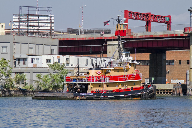
Built in 1984, by Rayco Ship and Main Ironworks of Bourg, Louisiana as the Franklin Reinauer for Reinauer Transportation Companies of Staten Island, New York.
The Franklin Reinauer was the last tug built by the yard, after the construction of three push boats for another company, in 1985 the yard went out of business.
The tug is the second to bear the the name. The first tug that bore the name Franklin Reinauer was renamed as the Matthew Tibbetts.
She is a twin screw tug rated at 2,600 horsepower.

– photo by Mitch Waxman
Pictured in many poses and places in this posting, and presented perspicuously is the tugboat which men call the Franklin Reinauer. Often garish, the “colorway” of each tugboat company is designed to be instantly recognizable at distance. There is something lovely about the Reinauer company’s brand colors of scarlet and orange, which provides primal contrasts with the surrounding azure and cerulean waterscape of New York Harbor.
from fireboat.org
When the Coast Guard called for all assistance, some tugboats were already at the scene with others making ready to assist. The tugboat Franklin Reinauer, under Capt. Ken Peterson and followed by three other Reinauer tugboats, arrived at the Battery seawall around 1130. Peterson said he radioed the MCC aboard the pilot boat New York for permission to go to the Battery seawall to take on passengers. Seeing 10 other tugboats standing off the Battery, he radioed them to come to the seawall. “People started running for the boats and I got off and started directing traffic,” Peterson said. “The first day, we had 27 tugboats on the Battery wall and five at Pier 11.” Tugboats from Moran, McAllister, Turracamo, Reinauer, Penn Maritime, Skaugen PetroTrans, Weeks Marine and other companies responded and continued to arrive during the afternoon. “It quickly became a collaborative effort with Andy McGovern, Ken Peterson and me determining how to best employ all the resources,” Day said.
Fire-fighting efforts at Ground Zero relied heavily on water supplied by two city fireboats and a welcome addition, the ex-New York City fireboat John J. Harvey. Privately purchased by outbidding the scrap dealers in 1999, the boat had been repaired since then and docked at Hudson River Pier 63.
– photo by Mitch Waxman
Luck has placed me at enviable vantages all summer, and an enormous amount of time has been spent on and around the harbor, during which the Franklin Reinauer seemed almost a companion. Everywhere I went, it seemed the tugboat was there too. In the shots above, the Franklin Reinauer was maintaining a static position before the Pulaski Bridge on the Newtown Creek, undoubtedly awaiting the arrival of some stalwart steward of the drawbridge who would open the span and allow it further egress.
from wirednewyork.com
Newtown Creek is woven deeply into the city’s history. Until the Dutch arrived, the Maspetches Indians lived along its banks in what is now Maspeth, Queens. Some believe that Captain Kidd used a friend’s waterfront property there to stash his plunder. The creek was part of a boundary dispute from the mid- 1600’s to the mid-1700’s between Bushwick and Newtown, the precursors to Brooklyn and Queens.
But it was through commerce that the waterway came into its prime.
By the 1850’s, the creek was an industrial center that both fueled and paralleled the explosive growth of New York. Glue factories, smelting and fat-rendering plants, one of the earliest kerosene refinery and other smelly enterprises clustered along the shores of the creek and its little tributaries. The toxic sludge from these businesses got company in 1856, when the city decided to dump raw sewage directly into the water, a practice that continued for decades.
In the 1920’s and 30’s, the creek was widened to accommodate the growing traffic. In its heyday, the bridges that crossed it opened tens of thousands of times a year.
“Newtown Creek was a highway,” said Bernard Ente, a local historian. “It was just boats instead of trucks.” He estimated that 500 enterprises lined the creek at its peak. Large boats brought in raw materials and fuel and took out oil, fat, varnish, chemicals and metals.

– photo by Mitch Waxman
There it is again, this time in the legend choked waters off of Red Hook, and exiting the Erie Basin. A small number of Reinauer tugs and barges are often observed here at Erie Basin, which is known to most New Yorkers for the large Ikea store and NY Water Taxi Ferry service which docks here.
from pbs.org
From the mid-1800s to the mid-1900s, Red Hook’s port made it a thriving industrial neighborhood of mainly Italian and Irish American dockworkers. It was also home to one of the first Puerto Rican neighborhoods in New York City. By 1950, Red Hook had 21,000 residents, many of them longshoremen living in the Red Hook Houses, a public housing project built in 1938 to accommodate the growing number of dockworkers and their families. The neighborhood had a tough reputation—with such notorious figures as Al Capone getting their start there as small-time criminals—and its seedy side was immortalized in movies such as the On the Waterfront (1954), starring a young Marlon Brando.
When containerization shipping replaced traditional bulk shipping in the 1960s, many businesses at the Red Hook ports moved to New Jersey—as did the jobs. Unemployment increased quickly as industries abandoned Red Hook, and the neighborhood’s economy underwent a rapid decline. By the 1970s and ‘80s, it became known as being a crime-ridden, desolate neighborhood, severed from the rest of Brooklyn.

– photo by Mitch Waxman
Mundane and sometimes odd coincidences of geography, maritime, and industrial usage create an unbearable historical similarity between Red Hook and Greenpoint which are deeper and more meaningful than some merely visual verisimilitude. Just on the other side of Erie Basin is the legendary Gowanus canal, Newtown Creek’s superfund.
from brooklyncb6.org
The industrial businesses that exist in Red Hook rely on trucking as the primary way to move goods and freight into and out of the area. Heavy truck traffic has had a serious impact on the residential population and most likely contributed to infrastructure failures and the collapse of some of the older buildings in the area. The geological substrata of this coastal floodplain region contains a dense organic layer of red clay (hence the “red” in Red Hook) that exacerbates the longitudinal transmission of surface vibrations. For years efforts have been underway to reevaluate the existing Truck Route network with an eye toward minimizing its direct impact on the residential community while optimizing its intended industrial usage. The existence of truck-based solid waste transfer stations, that provide little by way of economic development of the community, has contributed to the problem of truck traffic in a major way.

– photo by Mitch Waxman
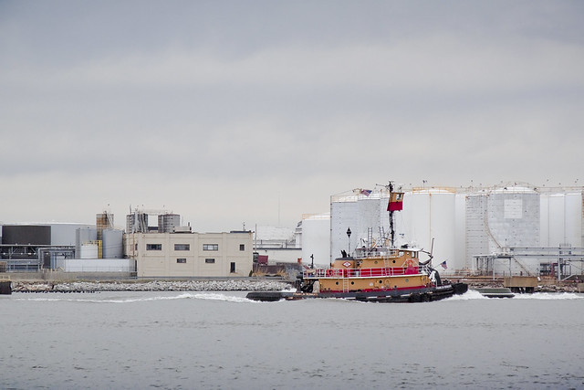
The Newtown Creek and Gowanus Canal have both been largely abandoned by those industrial forces which ruined their honor, but the tugboat has also and often been sighted in the place where these forces find modern occupation- the storied waterway called the Kill Van Kull.
Here is the Franklin Reinauer straddling this currently undefended border between New York and New Jersey.
from wikipedia
The name “Kill van Kull” has its roots in the early 17th century during the Dutch colonial era, when the region was part of New Netherland. The naming of places by early explorers and settlers during the era often referred to a location in reference to other places, its shape, its topography, and other geographic qualities. The area around the Newark Bay was called Achter Kol. The bay lies behind Bergen Hill, the emerging ridge of the Hudson Palisades which begins on Bergen Neck, the peninsula between it and the Upper New York Bay. Behind or achter the ridge, was a col or passage to the interior. Kill comes from the Middle Dutch word kille, meaning riverbed, water channel, or stream. During the British colonial era the bay was known as Cull bay.
Kill van Kull translates as channel from the pass or ridge. The name of the sister channel to the Kill van Kull, the nearby Arthur Kill, is an anglicization of achter kill meaning back channel, which would refer to its location “behind” Staten Island.
– photo by Mitch Waxman
Preparations for a vast undertaking, as mentioned in the first sentence of this evasive post, have finally been completed- a task which Sisyphus himself would have appreciated. Woe, that today I cannot accomplish my sincerest desire to announce these upcoming events. All a humble narrator can say at this moment would be:
Want to see something cool?
Bring a camera, and ID,
Follow me…
from wikipedia
Seagoing tugboats are in three basic categories:
- The standard seagoing tugboat with model bow that tows its “payload” on a hawser.
- The “notch tug” which can be secured in a notch at the stern of a specially designed barge, effectively making the combination a ship. This configuration is dangerous to use with a barge which is “in ballast” (no cargo) or in a head or following sea. Therefore, the “notch tugs” are usually built with a towing winch. With this configuration, the barge being pushed might approach the size of a small ship, the interaction of the water flow allows a higher speed with a minimal increase in power required or fuel consumption.
- The “integral unit,” “integrated tug and barge,” or “ITB,” comprises specially designed vessels that lock together in such a rigid and strong method as to be certified as such by authorities (classification societies) such as the American Bureau of Shipping, Lloyd’s Register of Shipping, Indian Register of Shipping, Det Norske Veritas or several others.These units stay combined under virtually any sea conditions and the “tugs” usually have poor sea keeping designs for navigation without their “barges” attached. Vessels in this category are legally considered to be ships rather than tugboats and barges must be staffed accordingly. These vessels must show navigation lights compliant with those required of ships rather than those required of tugboats and vessels under tow. Articulated tug and barge units also utilize mechanical means to connect to their barges. ATB’s generally utilize Intercon and Bludworth connection systems. Other available systems include Articouple, Hydraconn and Beacon Jak. ATB’s are generally staffed as a large tugboat, with between seven to nine crew members. The typical American ATB operating on the east coast, per custom, displays navigational lights of a towing vessel pushing ahead, as described in the ’72 COLREGS.
Harbor tugs. Historically tugboats were the first seagoing vessels with steam propulsion, providing freedom from the restraint of the wind. As such, they were employed in harbors to assist ships in docking and departure.
River tugs River tugs are also referred to as towboats or pushboats. Their hull designs would make open ocean operation dangerous. River tugs usually do not have any significant hawser or winch. Their hulls feature a flat front or bow to line up with the rectangular stern of the barge.
uncommented masonry

– photo by Mitch Waxman
It all started when I was checking to see if I could find out anything more about the Blissville Banshee.
As the sum total of that which might be gathering dust on library shelves has not yet been digitized, categorized, and assigned metatags- there is an awful lot of stuff which is not available to the prying eyes of primarily nocturnal creatures like myself. Google books is an ongoing project, for instance, and every month or so some new (old) document appears online which is Newtown Creek oriented that I might slaver over.
from wikipedia
Google Books (previously known as Google Book Search and Google Print) is a service from Google that searches the full text of books that Google has scanned, converted to text using optical character recognition, and stored in its digital database. The service was formerly known as Google Print when it was introduced at the Frankfurt Book Fair in October 2004. Google’s Library Project, also now known as Google Book Search, was announced in December 2004.
Results from Google Book Search show up in both general web search at google.com and through the dedicated Google Books site (books.google.com). Up to three results from the Google Books index may be displayed, if relevant, above other search results in the Google Web search service (google.com).

– photo by Mitch Waxman
Hence my periodic searches conducted for topics of which I’ve heard only hints of in the past- Case’s Crew for instance, or the aforementioned Blissville Banshee. It was one of these fishing expeditions into the ever expanding archival universe of the vast inter webs that led me to a certain structure, which sits at 30-28 Starr Avenue, just a couple of blocks from that malignant exemplar of the price of unregulated capitalism known as the Newtown Creek. It’s ordinary enough looking, branded with corporate logos and quite visible from many parts of Long Island City and Brooklyn.
from the Friends’ intelligencer, Volume 35, courtesy google books
The early history of Friends in Newtown and Maspeth Kills is marred by the irregularities of the Ranters, who claimed to be Friends, and intruded on their meetings.
Such was Thomas Case, who (1674) was forbidden by the Court to entertain the wife of William “Smith. His wife, Mary Case, was fined £5 for interrupting Rev. William Leveridge, while preaching, by saying to him: “Come down, thou whited wall that feedest thyself and starvest the people.” Samuel Scudder sent a long, scandalous letter to Mr. Leveridge.
The Court put Case and Scudder under bonds not “to seduce and disturb the people.”

– photo by Mitch Waxman
Let’s start at the beginning, though.
Borden Avenue is one of the older pathways in New York and particularly so for Queens, as the modern street was designated as Borden Avenue in 1868. It allowed egress from the docks at Hunters Point to the incalculably far Newtown and passed by the thriving village of Maspeth along the way. Originally a plank road set roughly into the swampy lowlands which adjoined the Newtown Creek, what would become Borden Avenue eventually progressed to the point of regular horse drawn (and then electric) street car service by the late 19th century and beginning of the 20th. It became a natural place for heavy industries to gather, and in the 1870’s and 80’s, rail road switches and “rights of way” followed their customers here.
The Long Island Railroad terminal at Hunters Point is and was on Borden Avenue, and rail tracks run parallel to Borden Avenue’s path, along what would have once been known as Creek Street. Critically, these were both freight and passenger tracks.
As of 1908, a retractile vehicle bridge crossed Dutch Kills, which we call the Borden Avenue Bridge (and which replaced the earlier wooden plank road drawbridge).
Today Borden is severed and overran by the sprawling girders of the Queens Midtown Expressway section of the much larger “Long Island Expressway”, and most of the tracks which crossed it at grade are cut or buried in the road asphalt.
from wikipedia
The Long Island Expressway was constructed in stages over the course of three decades. The first piece, the Queens–Midtown Tunnel linking Manhattan and Queens, was opened to traffic on November 15, 1940. A highway connecting the tunnel to Laurel Hill Boulevard was built around the same time and named the “Midtown Highway”. The tunnel, the Midtown Highway, and the segment of Laurel Hill Boulevard between the highway and Queens Boulevard all became part of a realigned NY 24 in the mid-1940s. In the early 1950s, work began on an eastward extension of the Midtown Highway. The road was completed to 61st Street by 1954, at which point it became known as the “Queens–Midtown Expressway”. By 1956, the road was renamed the “Long Island Expressway” and extended east to the junction of Queens (NY 24 and NY 25) and Horace Harding (NY 25D) Boulevards. NY 24 initially remained routed on Laurel Hill Boulevard (by this point upgraded into the Brooklyn–Queens Expressway) and Queens Boulevard, however.

– photo by Mitch Waxman
Borden Avenue once formed the border of a community called Blissville (named for it’s founder and designer, Neziah Bliss of Greenpoint) which was meant to be an ideal residence for industrial laborers. It was, for a while.
Calvary Cemetery was sited in Blissville in 1848, which literally ate half the neighborhood, and the industrial concerns which employed the local labor had taken up valuable waterfront properties at the Newtown Creek. These industrial entities were notoriously onerous neighbors whose factories rendered Blissville a stinking slum and literally the wrong side of the tracks.
Dutch Kills and the land surrounding it to the south west were considered to be a pestilential swamp best known for malaria, and upstream from Blissville were the bone boilers and fat rendering factories so conspicuous in the historical record for a wholesale degradation of the environment. Suffice it to say that the population of Blissville declined precipitously from 1850 to 1900, from a residential point of view (although people still live here, even today).
from wikipedia
Blissville is a neighborhood in the New York City borough of Queens. It is part of Long Island City. It is bordered by Calvary Cemetery to the east; the Long Island Expressway to the north; Newtown Creek to the south; and Dutch Kills, a tributary of Newtown Creek, to the west. Blissville was named after Neziah Bliss, who owned most of the land in the 1830s and 1840s. Bliss built the first version of what was known for many years as the Blissville Bridge, a drawbridge over Newtown Creek, connecting Greenpoint, Brooklyn and Blissville. It was replaced in the 20th century by the Greenpoint Avenue Bridge, also called the J. J. Byrne Memorial Bridge, located slightly upstream.
Blissville existed as a small village until 1870 when it was incorporated with the villages of Astoria, Ravenswood, Hunters Point, Dutch Kills, Middletown, Sunnyside and Bowery Bay into Long Island City.

– photo by Mitch Waxman
At the end of the 19th and beginning of the 20th centuries, a Cambrian explosion of “scientific manufacturers” (which is an actual and atavist business terminology from the time) arose within the industrial quarters of the United States and especially around the Newtown Creek. Great corporations were born along the creek, in the fields of chemical manufacturing and metal refining, petroleum refining and distribution, electrical generation and supply, and especially the field of automotive vehicle manufacturing.
There were now machines that could fly, or mechanically navigate the seas, but it was the automobile which struck hardest in the public’s mind and ending up driving the national economy.
from wikipedia
By the early 1880 generators were beginning to power arc lamps in Britain and France, but they generated high temperatures and sparks that prevented widespread adoption. In 1880, Thomas Alva Edison developed and patented a long-lasting incandescent lamp based upon the previous work of many inventors. Like Bell, Edison immediately set about commercializing his invention through a shrewd business plan involving companies that would manufacture the whole technological system upon which the “light bulb” would depend – generators (Edison Machine Company), cables (Edison Electric Tube Company), generating plants and electric service (Edison Electric Light Company), sockets, and bulbs. As in other industries of the era, these companies achieved greater efficiencies by merging to form a conglomerated General Electric company. Lighting was immensely popular: between 1882 and 1920 the number of generating plants in the US increased from one in downtown Manhattan to nearly 4,000. While the earliest generating plants were constructed in the immediate vicinity of consumers, plants generating electricity for long-distance transmissions were in place by 1900. To help finance this great expansion, the utility industry exploited a financial innovation known as the “holding company”; a favorite holding company investment among many was the Electric Bond and Share Company (later much-changed, and known as Ebasco), created by the General Electric company in 1905. The abuse of holding companies, like trusts before it, led to the Public Utility Holding Company Act of 1935, but by 1920, electricity had surpassed petroleum-based lighting sources that had dominated the previous century.

– photo by Mitch Waxman
In an age before refrigeration, being a “locavore” wasn’t an ethical or fashionable choice, it was a necessity.
The speed of a horse and wagon could never be considered dependable though, especially when carrying a heavy load of perishables from say… Bosjwick to Blissville. Whether it was meat, milk, or especially beer- it had a quick shelf life whether it suffered under the gaze of the burning thermonuclear eye of god itself or endured the freezing temperatures of a New York winter.
Additionally, a horse needed rest and food and water, which all needed to be prearranged. Horses also had a tendency to die from overwork. The automotive craze began when the brewers of beer realized what some contrivance called a “truck” could do.
from wikipedia
The word truck might have come from a back-formation of truckle with the meaning small wheel, pulley, from Middle English trokell, in turn from Latin trochlea. Another explanation is that it comes from Latin trochus with the meaning of iron hoop. In turn, both go back to Greek trokhos meaning wheel from trekhein that meant “to run”. The first known usage of “truck” was in 1611 when it referred to the small, strong wheels on ships’ cannon carriages. In its extended usage it came to refer to carts for carrying heavy loads, a meaning known since 1771. With the meaning of motor-powered load carrier, it has been in usage since 1930, shortened from motor truck who dates back to 1916.

– photo by Mitch Waxman
The reason that so many parts of the Newtown Pentacle host a former brewery, not unlike the Ulmer site in Bushwick, is that Beer didn’t used to come in bottles or pressurized kegs but was instead shipped in barrels. These barrels were delivered daily, which meant that the brewer had to be centrally located to service the various saloons, beer gardens, and bars which formed it’s clientele. This called for an eternal struggle against random happenstance, and the relatively shallow load that a horse cart was capable of carrying created high labor and livestock costs and limited growth. Suffice to say that the beer brewers needed a more reliable form of transportation that could handle the heavy products they produced.
The automotive “truck” could work all day and night with one driver, and carry many times the tonnage possible with a carriage.

– photo by Mitch Waxman
Blissville had long ago rebelled against the baronial farmers of Newtown and joined with its ancient sisters in forming Long Island City, which would become an early center for automotive manufacture. The political elites of Manhattan, who had just engineered the consolidation of the City of Greater New York, were anxious to develop western Queens and land was cheap for the well connected. Vast building lots were sold, and an incredible landscape of titan masonry was flung at the sky, with the intention of capturing and controlling vast amounts of treasure and discovering untold possibilities.
from wikipedia
The City of Greater New York was a term commonly used originally to refer to the expanded city created on January 1, 1898 by the incorporation into the city of Richmond County, Kings County, Queens County, and the eastern part of what is now called The Bronx (east of the Bronx River). The west Bronx, west of the Bronx River, had been annexed to the City and County of New York in 1874, and was known as the Annexed District. The City of Brooklyn had also expanded by annexation.
The phrase City of Greater New York was never a legal or official designation as both the original charter of 1898 and the newer one of 1938 use the name of City of New York.
The consolidation movement was the work of several progressive politicians, most prominently Andrew Haswell Green so some opponents derided the effort as “Andy Green’s hobby.” The center of the plan was the consolidation of the twin cities of New York and Brooklyn, whose fire departments had already been consolidated. The addition of Long Island City and various rural areas anticipated the spread of urban sprawl to those areas. With the Republicans historically more powerful in Brooklyn and the Democrats elsewhere, partisan politics played a role, each major political party hoping to dominate the consolidated city.

– photo by Mitch Waxman
By 1915, there approximately 40,000 automotive trucks plying the streets of New York City.
What’s surprising is that 25% of them were electric.
Lords and ladies of Newtown, I present to you the last mortal remains of the General Electric Vehicle Company, 30-28 Starr Avenue, Long Island City– manufacturer of a substantial number of those electrical trucks.
Here’s the way the place looked just before the time of the first World War, courtesy google books
Another historic view can be seen in this nytimes.com archive article

– photo by Mitch Waxman
General Electric Vehicle Company was originally the Electric Vehicle Company, until it was acquired by one of those “scientific manufacturers”- a small but growing firm which called itself “General Electric“. GE was a direct creation of a fellow named Edison, whose little power generating concern in NYC hadn’t quite “consolidated” itself yet.
General Electric Vehicle, like all automotive companies, was in competition with an upstart from the midwest named Ford. Things hadn’t been decided yet, from a consumer point of view, between electric motors or gasoline ones, but there was another company out there which had strong feelings on the subject called Standard Oil.
I’ve read allusions to some deal between Ford and Edison to stay out of each others way, but for awhile Edison was manufacturing (and driving) electric cars.
Here’s A GEVC truck from 1906, courtesy google books

– photo by Mitch Waxman
In the early 20th century, this was the second largest factory space in Long Island City (after the Loose Wiles bakery) sitting on 3 entire blocks of the 19th century street grid and comprising some 8 square acres. 2,000 people worked there. The largest of the structures, which has been conspicuously displayed throughout this post, survives and serves modernity as a gargantuan self storage facility. Other structures of the complex survive, and remnants of the rail spar that served it can be observed on Review Avenue just beyond Borden. Part of its footprint is occupied by the Silvercup Studios East location.
GEVC became the premier manufacturer of Electric Vehicles here, as well as being the only concern in the Untied States licensed to build Daimler’s “Mercedes” gasoline cars and trucks.
from The American review of reviews, Volume 51 By Albert Shaw, courtesy google books
The big principle is that electricity is now the world’s best source of power, and enables business men to “team by electricity.” The Company long ago learned that the work to be performed decides the building of the vehicle. But very interesting is the fact that while all the six G. V. models but one were standardized seven years ago, each truck is built to fit the industry, the locality, and the use it will meet. Starting with a standardized chassis, a body suitable for a given business is built and placed on the chassis, but not before experts have adjusted battery, motor and speed to fit local road conditions. That is, the “power plant” of a 2-ton truck as revealed in battery, motor, etc., is specifically adapted to hilly
Seattle or level Washington, D. C, as the case may be. In the splendid Long Island City plant of the General Vehicle Company the exact facts of the customer’s condition and his locality now determine what that truck must be to succeed. And it does succeed. The haphazard peddling of job-lot trucks must disappear, just as the stock-jobbing era has passed in automobile truck manufacture.
Consequently you can buy an electric truck to-day with the same certainty of what it will do under your particular circumstances as you can buy any other staple commodity. A concern like the General Vehicle Company will actually refuse to sell you a truck which is not what your work requires. It will not promise you all kinds of free service, new tires, free bodies, and free rebuilding. It does not have to do this, as the now bankrupt concerns did have to, in order to try to offset the serious deficiencies in the service a truck was supposed to give. A General Vehicle truck does what it is built to do—and is sold on a business basis, with no secret about what will happen to the man who buys it after he has used it awhile. A table of standard costs to fit various types, conditions and requirements, works out as accurately as a multiplication table.

– photo by Mitch Waxman
General had an interesting scheme to power the trucks, which involved the shipping of batteries to and from a power plant in Connecticut, which would charge industrial base rates for charging them. A series of labor actions and the emerging predominance of the gasoline powered internal combustion engine served to weaken and eventually bankrupt General, and the company was ultimately done in by the first World War because of that Daimler contract.
Nobody wanted German cars or trucks anymore, you see.
In 1918, the War Department of the United States engineered the sale of the plant to the Wright Martin Aircraft company, in order to facilitate the manufacture of airplane engines at the factory. When Wright Martin took over, the payroll skyrocketed to include an astounding 8,000 employees.
from wikipedia
In order to overcome the limited operating range of electric vehicles, and the lack of recharging infrastructure, a exchangeable battery service was first proposed as early as 1896. The concept was first put into practice by Hartford Electric Light Company through the GeVeCo battery service and initially available for electric trucks. The vehicle owner purchased the vehicle from General Vehicle Company (GVC, a subsidiary of the General Electric Company) without a battery and the electricity was purchase from Hartford Electric through an exchangeable battery. The owner paid a variable per-mile charge and a monthly service fee to cover maintenance and storage of the truck. Both vehicles and batteries were modified to facilitate a fast battery exchange. The service was provided between 1910 to 1924 and during that period covered more than 6 million miles. Beginning in 1917 a similar successful service was operated in Chicago for owners of Milburn Light Electric cars who also could buy the vehicle without the batteries.

– photo by Mitch Waxman
Wright Martin Aircraft– Wright as in Wright Brothers, and Martin as in Martin Marietta, departed the place at some indeterminate point in the early 20th century. References have been found which identify the interim tenants of the structure as having been engaged in the manufacture of exotic lithographic and photographic equipment, includes both industrial landscaping and floral supply businesses, and a host of smaller operations involved in warehousing, interstate shipping, and local trucking companies also called this building home base. Ultimately, it became a self storage warehouse.
This is building 3 of the General Electrical Vehicle Complex, there were at least 7.

– photo by Mitch Waxman
Contemporaneous accounts of the place describe it as occupying a spot between Review, Starr, and Borden avenues, bounded by the no longer mapped Fox and Beaver streets. Certain sources and allies were taken aback by my queries about the two streets, thinking that your humble narrator was being ribald, but such profane interpretations of my question were later greeted with scans of a historical map (which I cannot present here for copyright reasons) that confirmed the location and identity of the modern structure.
Suffice to say that Fox and Beaver follow the course set by 30th street and 31st place were they to continue to the Newtown Creek waterfront.

– photo by Mitch Waxman
An effort was made to contact the employees of the self storage warehouse, and though they were thoroughly friendly and attentive, the current staff were somewhat taken aback by my queries. I displayed the historic shot of the building, but they did not have any anecdote to offer about historic remnants or curious machinery, which means that the structure must have been thoroughly gutted before modern times.
You never know what you’re going to find along the Newtown Creek, as I always say, but I’m still wondering about the Blissville Banshee.


