Archive for the ‘newtown creek’ Category
ironic placeholder

– photo by Mitch Waxman
Short one today, just two shots I kind of like. Having to tow a tow truck just strikes me as some sort of karmic parable in the first one.

– photo by Mitch Waxman
Speaking of karmic parable, in the second are two nicely red Panavision trucks.
There was a fair amount of activity going on near Dutch Kills this weekend on 29th street and the impression I received was that the sitcom “30 Rock” was filming something in the orange building to your right.
Major posting coming tomorrow. I’d suggest making a cup of tea or coffee before wading into it. I found something incredible in Long Island City recently, which will be presented tomorrow at this- your Newtown Pentacle.
quite convinced
– photo by Mitch Waxman
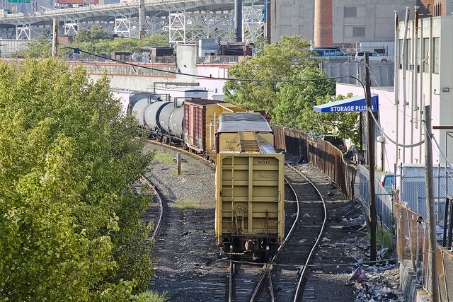
Recent financial setbacks and personal problems infect your humble narrator with a form of deep melancholy and a vast ennui. When such moments come upon me, there is a certain pizzeria in Greenpoint (Norman corner of Manhattan, near the train) whose offerings can be summed up best as: an actual and old fashioned “Brooklyn Slice”. On the day I spied this collection of rail cars at the so called “Bliss Tower” in DUGABO, I had scuttled forth from the rolling hillocks of my beloved Astoria in pursuit of one of these aforementioned slices, in an effort designed to brighten my mood.

– photo by Mitch Waxman
Errors and omissions mar my record when discussing the Rails, much to the chagrin of the knowledgable railfan community (whose helpful comments and corrections are always appreciated here at Newtown Pentacle). As such, what I can categorically tell you is that this a New York & Atlantic Locomotive, one of the 11 engine units which service the 269 miles of track operated upon by the Glendale based company in Brooklyn, Queens, and both Nassau and Suffolk counties. It shares much of its road with the passenger based Long Island Railroad, and NY&A’s distinctive emerald, white, and black engines are regularly observed around the Newtown Creek.

– photo by Mitch Waxman
Across the Newtown Creek Watershed, one encounters a landscape built for rail. Long abandoned track beds lie buried in inches of road asphalt, pointing the way to industrial giants long absent. Train stops orphaned from their purpose, spars and switches which were rudely severed to make room for modernity. All of it operated at street grade, and the remnants of the iron road are often the only tangible remains of great concerns and financial largesse. If you follow the right spar, you’ll discover that the NYPD Barricades unit was once Thypin Steel, or that LaGuardia Community College was once the Loose Wiles bakery and part of the Degnon Terminal.

– photo by Mitch Waxman
Within the communities which surround the Newtown Creek, a complaint often repeated concerns the presence of large numbers of trucks utilizing local streets in their quest to move goods from A to B. I had the privilege last year of attending a presentation by certain factions within the Port Authority that described a proposal which would eliminate several thousand truck trips a day throughout the City and over the George Washington Bridge, simply by shipping New York City’s garbage out to land fill utilizing locomotive rather than automotive means. Calculations about air pollution, road maintenance costs, and vehicular accident rates were presented at the time which compared rail quite favorably with truck based shipping.There was a maritime component to the plan as well, which was a bit hazy, but the train concept was spun gold.

– photo by Mitch Waxman
The shot above represents an NY&A Locomotive making a drop off of a customer in Maspeth near the ill fated St. Saviour’s church site, where they will uncouple a car or two for the unloading or loading of certain cargo. An unthinkable amount of trucks would be required to carry the same tonnage. The subject of Green Technology and “Greening New York” is often bandied about by many these days. Too much of the conversation, however, is “cocktail party environmentalism”- which sounds great but just isn’t practical on a policy level.
I’ve developed this funny notion, however, that the way forward is actually to re-imagine and re-invent the heaviest industry of them all.

– photo by Mitch Waxman
Rail infrastructure is what made Long Island City the factory of not just New York, but the entire world at the turn of the last century and multiple generations of capitalists and real estate interests founded vast fortunes because of the initial investment in it. Newtown Creek was the busiest waterway in North America, carrying more ship and barge traffic than the entire Mississippi for a time, and all of that maritime activity was fed by rail. Intermodal rail floats actually carried whole trains across the harbor to Manhattan, Staten Island, New Jersey and beyond. Imagine the benefits, in both individual wealth and environmental health, were we to try and save the future by looking for solutions in the past.
I’m still kind of forming this idea up for myself, but the key to it is containerization. More on this soon.
What do you, lords and ladies, think on the subject? Use the comments “Reply box” below, if you would like to start a conversation about it.
little memories

– photo by Mitch Waxman
What you’re looking at used to be one of the centers of the world, the Long Island Railroad terminus at 2nd street and Borden Avenue. The original version of the place was built in 1861 and provided egress to Manhattan via an enormous ferry terminal which shuttled commuters back and forth across the East River. This was (and is) the literal “End of the Line”.

– photo by Mitch Waxman
The station was electrified (WRONG, Sharp Eyed Reader “Kevin” points out that these are diesel trains) along with the rest of the LIRR western spurs, when the tunnels to Manhattan were opened in the early 20th century. The tunnels allowed direct transport to Penn Station, eliminating those delays associated with weather which plagued the ferry service.
Today, excess capacity during the slack time between rush hours can be found idling on the tracks on any given day.

– photo by Mitch Waxman
Several versions of the station have been installed here- for instance, a calamitous fire in 1902 destroyed the wooden buildings and train sheds which distinguished the place in the late 19th century. A trip to the acknowledged masters on the subject- the website arrts-arrchives.com is recommended for the curious.
revel and chaff

– photo by Mitch Waxman
As soon as the rain died down, I descended from Newtown Pentacle HQ here in the rolling hillocks of Astoria to the so called “Zone A” to see what Irene might have wrought here in western Queens. The shot above is from Second Street near Borden Avenue, at the largish worksite which Skanska has been employing hundreds for the last few months. Cleverly, the construction giant had dug a diversion ditch to allow storm water drainage.
Smart.

– photo by Mitch Waxman
“There will be plenty of cameras walking around in Tower Town, so it would be silly of me to spend much time there” were the actual words spoken to my walking companion, who we’ll call the Charismatic Croat (CC). CC was also told that we’d be taking a short walk, and would be back in a half hour. He’s used to my lies and wasn’t surprised when we had inexorably headed for another part of “Zone A”.
All through the storm, I was wishing that I had the camera out at Newtown Creek, or at least Dutch Kills.

– photo by Mitch Waxman
Curiosity about the actions of the much feared storm surge upon the fragile bulkheads of Dutch Kills was killing this cat, and I dragged CC back and forth over these streets. There was some flooding, but in the usual places that flood anyway. Back on 2nd street, a few nice shots of the surge were captured by Jesse Winter and others, and an actual wave of East River had risen up and flooded 2nd. The Crab House was bailing water from their basement and more than one giant puddle still remained.
Down at Dutch Kills, 29th street and the large truck yard which houses this cement company were under a foot or more of water- but they are regularly immersed by small amounts of rain anyway.

– photo by Mitch Waxman
What made the day noteworthy, from a Newtown Creek point of view, was this little river of urban chocolate flowing out of one of the many CSO’s (Combined Sewer Outfall) which are found abundantly along the waterfront of the Creek and it’s tributaries. It smelled just the way it looks like it might. One often sees discharges coming from these CSO’s, but this was just a spectacular flow.

– photo by Mitch Waxman
I will point out that this could be soil washed into the pipes during the tremendous amount of rain which Irene brought to Queens. It could be sand or actually be a chocolate spill at some industrial confectionary which got washed into the sewers or something. That’s what I said to CC at the time.
Doesn’t smell like chocolate, the Charismatic Croat opined.
…hits the fan

– photo by Mitch Waxman
Council Member Van Bramer sent this out to his mailing list today, regarding Hurricane Irene
As everyone knows by now, Hurricane Irene is expected to hit our area sometime Saturday into Sunday. We should all take precautions to be prepared for a storm of this magnitude. Some areas in our district are in evacuation zones and at high risk for flooding. Those areas of Hunters Point/Long Island City should familiarize themselves with the map below and know that should an evacuation be ordered, Newcomers High School (28-01 41st Ave.), Aviation High School (45-30 36th St.) and W.C. Bryant High School (48-10 31st Ave.) are your nearest evacuation centers. The City will make a decision about whether to order a mandatory evacuation of Zone A for the general public by 8:00 AM on Saturday. The evacuation centers will be open as of 5:00 PM today and the City is strongly recommending that people within these areas immediately make plans to go to alternative locations outside of Zone A starting tomorrow for the duration of the storm. The orange areas are Zone A. The yellow areas are Zone B. The green areas are Zone C.

We are also concerned about significant portions of the district including parts of Sunnyside, Woodside, Astoria and Maspeth that have experienced flooding during several recent storms. Our office has been and will continue to be in contact with the Department of Environmental Protection (DEP) and other city agencies throughout this weekend. Anyone experiencing difficulties as a result of Hurricane Irene should contact me and my office as soon as they occur. We will report problems in real time. For those outside of Zone A areas that have experienced flooding or are concerned that you may, please click on the link below on how to protect your valuables. In addition to calling our office, DEP is asking for reports of flooding to be called in to 311.
http://home2.nyc.gov/html/oem/downloads/pdf/flooding_guide.pdf
I have also been in touch today with NYCHA and the Mayor’s Office to make certain that Queensbridge, Ravenswood, and the Woodside Houses are included in any and all emergency plans including evacuation, should that be necessary. We will continue to be in regular contact with NYCHA throughout the storm.
While we continue to hope for the best, we must prepare for the worst. The city has published some useful information in securing your home during the storm. Please click on the link below for recommendations on how best to prepare for the hurricane.
www.nyc.gov/html/oem/html/ready/hurricane_guide.shtml
Given the high volume of traffic to OEM’s (Office of Emergency Management) website there have been delays and interruptions in gaining access to some of these links. For that reason, we also include the Red Cross’ Hurricane Safety Checklist below. We have also included information from OEM’s Hurricane Guide at the end of this email should that link not respond when you try it.
http://www.redcross.org/www-files/Documents/pdf/Preparedness/checklists/Hurricane.pdf
In advance of the hurricane I wanted to remind you that clogged catch basin grates can aggravate flooding. Although DEP staff – with the help of their colleagues at other agencies – are busy cleaning catch basins now, DEP has asked us to remind homeowners and residents that they welcome assistance in removing leaves, litter or other debris that may prevent water from flowing off the streets and into the catch basins. For any of you that aren’t familiar with catch basins the attached link to a page on DEP’s website has some text and visuals that will help explain why flooding occurs and how citizens can help DEP minimize flooding by removing debris where they see it blocking catch basin grates.
http://www.nyc.gov/html/dep/html/flooding/flooding_causes.shtml
I will be keeping my district office open on Saturday to field questions and concerns from constituents. Needless to say, we will close the office when the storm approaches and will reopen as soon as it is safe to do so. My district office number is (718) 383-9566. I will be in the district throughout the storm and encourage anyone with problems to email me concerns at jvanbramer@council.nyc.gov as well as using social media including Facebook (http://www.facebook.com/jimmyvanbramer) and Twitter (http://twitter.com/jimmyvanbramer) to reach me. You may also call 311. Please only call 911 if you have a very serious or life threatening emergency.
I hope this update and the attached information proves useful to you. Again, my staff and I will be working throughout the weekend and please do not hesitate to contact me should you need assistance.
Sincerely,

Jimmy Van Bramer
Council Member

– photo by Mitch Waxman
Additionally, the Council Member included the following information from the Office of Emergency Management
OEM’s Hurricane Guide
To secure your home if a tropical storm or hurricane watch is issued:
Bring inside loose, lightweight objects, such as lawn furniture, garbage cans, and toys.
Anchor objects that will be unsafe to bring inside, like gas grills or propane tanks. Turn off propane tanks.
Shutter windows securely and brace outside doors.
Place valuables in waterproof containers or plastic bags.
Help Others Prepare
- Check on friends, relatives, and neighbors, especially those with disabilities or special needs, and assist them with their preparation and evacuation.
- If you live outside an evacuation zone, offer to shelter family and friends who may need to evacuate.
If Asked to Evacuate, Do So Immediately
The City will communicate specific instructions about which areas of the city should evacuate through local media. If the City Issues an Evacuation Order for Your Area: Evacuate immediately. Use public transportation if possible.
If you are going to an evacuation center, pack lightly, and bring:
- Your Go Bag
- Sleeping bag or bedding
- Required medical supplies or equipment
- Let friends or relatives know where you are going.
What about my pets?
- Make sure your disaster plan addresses what you will do with your pet if a hurricane requires you to leave your home.
- Plan to shelter your pet at a kennel or with friends or relatives outside the evacuation area.
- Be sure you have supplies ready for your pet in the event of an evacuation, including food, a leash, a muzzle, proof of shots, and a cage or carrier.
Account for your special needs
- Consider your capabilities and make sure your preparedness plan addresses how your special needs affect your ability to evacuate and shelter.
- Determine if you will need assistance and arrange help from friends, family, or neighbors.
- Consider additional supplies and equipment that you may need to bring with you, such as medicine, icepacks, medical devices, and backup equipment. Bring food for your dietary needs.
- Include additional time and evaluate your transportation options.
IF YOU LIVE IN AN EVACUATION ZONE
Prepare A Disaster Plan
Develop a plan with your household members that outlines what to do, how to find each other, and how to communicate if a hurricane strikes New York. If you rent your home, renter’s insurance will insure the items inside your apartment. If you are a homeowner, make sure your home is properly insured — flood and wind damage are not covered in a basic homeowner’s policy.
Know Where You Will Go
The City strongly recommends evacuees stay with friends or family who live outside evacuation zone boundaries. For those who have no other shelter, the City will open hurricane shelters throughout the five boroughs.
To ensure efficient use of resources, the City will ask all evacuees to report to an evacuation center. Once at the evacuation center, evacuees will either be assigned to a hurricane shelter in the same facility or transported to an associated hurricane shelter by bus.
Every household member should have a small Go Bag — a collection of items you may need during an evacuation packed in an easy-to-carry container such as a backpack. A Go Bag should be easily accessible if you have to leave your home in a hurry.
Assemble an Emergency Supply Kit
You may be instructed to shelter in place (stay at home) during a hurricane. Keep enough supplies in your home to survive for at least three days.
If you do not live in an evacuation zone
All areas of the city could face hurricane-related hazards such as high winds, flooding, tornadoes, and loss of utilities. You may be instructed to shelter in place (stay at home) for several days until the hurricane passes.
If you live in a high-rise apartment building
Residents of high-rise apartment buildings may face special risks from hurricanes even if they live outside evacuation zone boundaries. If you live in a high-rise building outside an evacuation zone, be prepared to take shelter on or below the 10th floor. If you live in a high-rise building located in an evacuation zone, heed evacuation orders.

– photo by Mitch Waxman
This looks like it will be a profound event. Personally, I’m preparing for an uncomfortable few days, but that’s because I live inland and uphill in Astoria. Long Island City and Greenpoint on the other hand…
Our friends at liqcity.com have prepared an excellent posting on the Zone A situation, which can accessed here:
http://www.liqcity.com/life/long-island-city-and-hurricane-irene-a-match-made-in-well-well-see

– photo by Mitch Waxman
Newtown Creek Alliance, an organization of which I’m a member, issued this statement earlier today…
Flood Warning for Creek Neighborhoods
Mayor Michael Bloomberg announced on August 25th, 2011 that certain emergency measures will be instituted in low lying coastal districts referred to as “Zone A” (at high risk of coastal flooding) due to the expected arrival of Hurricane Irene in the New York City area late Saturday night. Much of the land surrounding Newtown Creek is designated as “Zone A” on the coastal flooding map prepared by City officials, including large tracts of Greenpoint and Long Island City. For a map of the affected areas, please click here.
Newtown Creek Alliance cautions residents of the affected areas to monitor the situation and be prepared to evacuate should authorities warrant it necessary. If an evacuation is recommended or ordered, information about evacuation centers and hurricane shelters may be found by calling 311 or at by visiting this website. Additionally, be mindful that during such an event, the flood waters could carry a significant load of pollutants and should not be ingested. Care should be taken upon any contact with skin.

– photo by Mitch Waxman
Sources within the City have discussed this storm with me in the most dire tones. If you live in an area designated for evacuation, please comply. I’ll be marching out into the brave new aftermath early Monday morning, if there’s something which you think I should point my camera at, please contact me here. Good luck, and assuming the availability of both electrical power and internet connectivity, I’ll post as the situation develops.
As this post was being prepared, Council Member Van Bramer passed along another message, ordering the mandatory evacuation of Zone A by 5 pm Saturday.


