Archive for the ‘newtown creek’ Category
quite submerged

– photo by Mitch Waxman
Today, I’m going to be uncharacteristically quiet, it’s all about the pictures. I was dreaming about flying again, in the manner of a super hero, and pulled these shots (some of which you’ve seen in other posts) together.

– photo by Mitch Waxman
Whenever I can attain some altitude, an attempt is made to record it, especially in the low lying areas of western Queens and North Brooklyn. In this shot, it was the Roosevelt Island Tram which elevated my point of view.

– photo by Mitch Waxman
Attempts and entreaties have been made- but so far- nobody in Long Island City has offered me roof or high floor access to shoot from one of the tower buildings. Haven’t asked anyone on Roosevelt Island yet, but the views of Queensboro and the East River must be glorious at night from there.

– photo by Mitch Waxman
I have been to the Ravell Hotel roof, which is in the lower right hand corner of the shot, which offers amazing views of the bridge and whose vantage lines up with the burning thermonuclear eye of God itself for “Manhattanhenge“.

– photo by Mitch Waxman
In Long Island City, the industrial zones are typically low lying in character, with few buildings exceeding 4 stories. Extreme reticence has been exhibited by property owners, when approached with requests of photographic access to their roofs or grounds. Insurance liability is the usual reply.

– photo by Mitch Waxman
The ultimate viewing platform, of course, would be from the Citibank Megalith. Like Odin on his hildskalf, one might observe the entire world from up there, seeing the in the perspective of that thing in its summit which cannot possibly exist and does not think or breathe, yet hungers.

– photo by Mitch Waxman
From up there, the entire soup bowl of New York Harbor is available for viewing. The megalith is visible from many faraway points in the harbor, and if you can see it- it can see you. On a clear day, the thing in its summit (were it to exist) can see the Narrows and Long Island Sound and Jamaica Bay and the Hudson.

– photo by Mitch Waxman
Terrestrial and aquatic vantages have been my only succor in recent months, but an urge to look down from above is upon me, and scry the ancient patterns of life which invisibly govern the present City.

– photo by Mitch Waxman
Probably why I’m dreaming of flying…
gleaming vividly

– photo by Mitch Waxman
An unusually personal posting today-
A continuing fascination with the complexities of maritime photography has taken up quite a bit of my summer in 2011. Tugboats, in particular, demand attention whenever I’m on or near the water. It probably has to do with having recently sold a couple of tug shots to the NY Times, illustrating an article in the weekender section profiling the Working Harbor Committee.
When you get paid for something you enjoy doing, life attains symmetry and seems to have a purpose, especially when the people writing the check are “the paper of record”.

– photo by Mitch Waxman
As has been my habit since childhood, late summer is when I assess “how it’s going”, figure out what isn’t working in my life and try to formulate a plan to get “back on track”. It’s been a great few months: working with Forgotten-NY and Greater Astoria Historical Society on their ambitious “2nd Saturday” series of tours, assisting the Working Harbor Committee with their multitudinous tours and events, helping design and produce an event for the New York City Centennial Bridge Commission, and conducting my own boat tours of Newtown Creek for Working Harbor and Metropolitan Waterfront Alliance’s City of Water Day. I’ve also presented the Magic Lantern show three times this summer- at Greater Astoria Historical Society, City of Water Day, and at a DEP event.
Additionally, Newtown Creek Alliance’s various events, presentations and public meetings have kept me quite busy. However, in the midst of working with all these wonderful people, my own operation and schedule has been damaged by inattention.

– photo by Mitch Waxman
One thing which is foremost in my mind, and which will be rectified in the coming weeks and months as we slouch toward fall and winter, has been the irregular schedule of postings here. Apologies are offered, contradicting my normal credo of “never complain, never explain”, but this blog is essentially a one man operation (although special kudos go out to Our Lady of the Pentacle and Far Eastern Correspondent Armstrong for unbelievable effort and support). Massive effort is underway to resume a normal and regular schedule of postings.
There will be one more HUGE announcement coming about a Newtown Creek event I’ll be offering in October, but I’m contractually obligated to not be more specific about it than that.
In short… Back in session.
Happy Birthday, Kosciuszko Bridge

– photo by Mitch Waxman
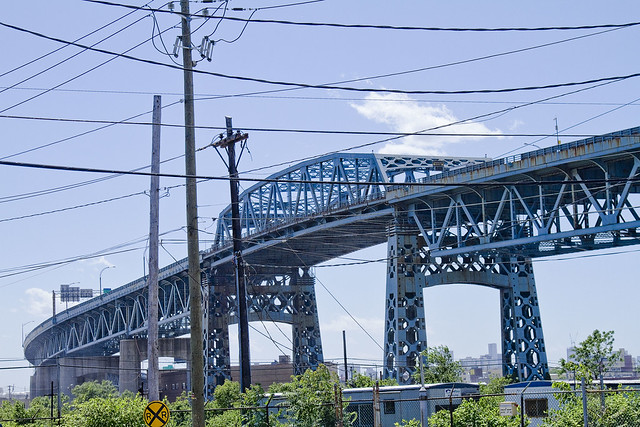
A virtual guarantee is offered that this is the only posting you will see today commemorating and wishing the Kosciuszko Bridge a happy 72nd birthday. Some 26,298 days ago, Robert Moses saw the first link in a crazy idea of his which would one day be called the “Brooklyn Queens Connecting Highway” open for business.

– photo by Mitch Waxman
The Meeker Avenue Bridge opened on August 23rd, 1939 (renamed in 1940 as The Kosciuszko Bridge) – some 631, 152 hours ago. It was promised to allow easy egress to the World’s Fair, and was a showpiece project for the Great Builder.

– photo by Mitch Waxman
From a Newtown Pentacle posting of December 8, 2010– in which the big K was described as thrice damned:
Damned Once- The Kosciuszko Bridge catches radio frequency emissions from several nearby commercial radio broadcast antennas. A lot of it.
Whatever knows fear burns at The Kosciuszko Bridge’s touch.
Damned Twice- The Kosciuszko Bridge is at extreme risk in the eventuality of a seismic event. The Brooklyn pier actually sits on the Creek bed, some 6 meters below grade, but the Queens side is anchored on piles driven into the mud. The hard soil around Queens Plaza will merely shake, but the land surrounding the Newtown Creek will liquify.
Damned Thrice- The Kosciuszko Bridge once had pedestrian walkways, but they were removed in 1961. Can you imagine what kind of photos would be possible on a pedestrian walkway 124 feet over the Newtown Creek?
– photo by Mitch Waxman
Like many things and people who are 72 years old, the Kosciuszko Bridge is not long for this world. Why not raise a glass to it tonight, and acknowledge its long service to the City?
Click here for a sentimental slideshow of the old girl from the last couple of years
another aperture

– photo by Mitch Waxman
An aerial shot from the former Loose Wiles biscuit factory (and modern day LaGuardia Community College) which shows the totality of the Dutch Kills turning basin and the properties which surround it. Special notice of the cement factory and the red white and blue self storage warehouse should be taken, and the Hunters Point Avenue Bridge and Long Island Expressway (just above center) which were described in earlier posts are also pointed out. Additionally, notice the two sunken barges in the lower left hand corner of the shot.
click for parts one, two, and three of this trip down Dutch Kills. This is the last of the four postings describing what I saw at Dutch Kills while on a Newtown Creek Alliance assignment.

– photo by Mitch Waxman
The stated mission of this exhibition was to catalog and photograph the little known bulkheads and shorelines of Newtown Creek and it’s various tributaries, and NCA had arranged for Riverkeeper to ferry us back and forth across the troubled waterway. Troubled is a politically correct way of describing the Newtown Creek watershed which native New Yorkers would translate into local patois as “all ‘effed up”, or which a military man would call “FUBAR”.

– photo by Mitch Waxman
Risible, the state of decay along these shorelines is startling. Dutch Kills has been largely abandoned by maritime interests, despite its once proud role as the central artery of the industrial complex called the Degnon Terminal. The corrosive affect of estuarine water upon cement and underlying steel has rotted away the manmade shorelines and bulkheads, carving away the efforts and labor of whole generations.

– photo by Mitch Waxman
There is no reason to say the name of the corporation which occupies the red, white, and blue self storage warehouse which sits above these pilings. It is immaterial to adjure any organization in Queens, whether it be governmental or corporate, for no one cares. It is remarkable, though, that the corrosive action of the waters of Dutch Kills have so undermined the foundations of this structure that grottoes have formed amongst its pilings.

– photo by Mitch Waxman
Remember, this was swamp land as late as the first decade of the 19th century. When Degnon’s people began their work here, at the Waste Meadows, there was barely any solid land between Hunters Point and Blissville. The LIRR, of course, had built their tracks sturdily and have no doubt that Standard Oil had engineered their grounds with proper drainage and stout foundations- but the inland path along Dutch Kills was nearly worthless.

– photo by Mitch Waxman
Degnon owned a construction company which was capable of doing the impossible, and his people had a special affinity for problems involving water. They made their name during the construction of the second East River (or Williamsburg) Bridge, were involved in the taming of the Wallabout Creek, and had recently been engaged by the newly consolidated City of Greater New York to complete the rail tunnels which would link Queens to Manhattan via the novel new Subway system. Those tunnels excavated a large amount of spoils and borings, which would be used to create the very ground around Dutch Kills as “landfill”.
By the first decade of the 20th century, enough compacted landfill was here to begin pouring concrete slabs, and upon those slabs the Degnon Terminal rose.

– photo by Mitch Waxman
This post will not cover the entire story of the Degnon Terminal. I would refer you to trainsarefun.com, and forgotten-ny for facets of the story, or suggest a visit to the Greater Astoria Historical Society for an attempt to get them to share their expertise on the subject. The tale of Michael Degnon is the stuff of scholarly dissertation. Degnon is buried in Calvary cemetery, and I suspect he rests uneasily because of what lesser men have done to his legacy.
There are two sunken fuel barges here, rusting away into history.

– photo by Mitch Waxman
Pictured above is the CSO Outfall BB-026 which vomits untreated storm water and sewage into Dutch Kills regularly, and it is one of the primary sources of water flowing into Dutch Kills. The boat began moving in a counter clockwise fashion at this point, swinging away from the 29th street address of the red, white, and blue self storage warehouse and toward the concrete factory.

– photo by Mitch Waxman
I’m unfamiliar with the role and identity of the two large pipes which are found beneath the concrete facility. The enormous slab of cement the factory is situated upon was once a rail switch, where short trip rail engines would await incoming barges. Once unloaded, these short trains would make deliveries to the industrial concerns which surrounded Dutch Kills.
Apparently, no small amount of conflict has arisen between the concrete company and environmental watchdogs over the years, but your humble narrator makes it a point of staying out of this sort of thing.

– photo by Mitch Waxman
The concrete industry around Newtown Creek often has fingers pointed at it, but again, large industrial concerns need to be sited “somewhere” to serve the interests of Real Estate and construction. The goal of many, including myself, is to ensure that in the days following the EPA Superfund cleanup of the Creeklands is that industry still feels welcome here. White collar corporate jobs are not an option for many, which is something often forgotten by those who spend their days in air conditioned Manhattan offices imagining the future of Queens.
These dirty industries must be compelled to “clean up their act” but cannot be regulated out of business.

– photo by Mitch Waxman
The boat turned away from the north eastern bulkheads of the Dutch Kills Turning Basin and we explored the bulkheads of the southern abutment. Again, the waters had carved into the underpinnings of the engineered ground. More abscesses and grottoes were observed cut into the cement and the visible wood seemed spongy and softened from the action of unknowable forms of microscopic life.

– photo by Mitch Waxman
I had to “bust a move” to conquer the deep shadows of early morning light here, as the merciless and burning thermonuclear eye of god itself was shining down unoccluded by cloud or atmosphere at this point. An external flash was attached to my trusty camera, which was “bounced” off the water. Anomalously, the green water created orange and red shadows in the reflected bursting of light.

– photo by Mitch Waxman
The Riverkeeper Captain who acted as our boatswain, John Lipscomb, checked his watch and announced that we had to beat a hasty retreat as the tidal actions of the East River would soon cause Dutch Kills to rise. Fearing that we might be trapped in Dutch Kills for a long interval, and having completed only a tiny fraction of our mission, Captain Lipscomb set course for the larger vessel which had launched our tiny “Tin Boat” which was docked at Whale Creek.

– photo by Mitch Waxman
The physical effects of the air and environment here were enormous, but the effort and risk of the journey were worth undertaking. Long have I desired to see Dutch Kills from water level, and to see the place as few others have.
pillars and niches

– photo by Mitch Waxman
You might recall, Lords and Ladies of Newtown, that back on December 11th of 2010 the 100th anniversary of the Hunters Point Avenue Bridge was commemorated by the New York City Bridge Centennial Commission and that I was one of the two Parade Marshalls for the celebration.
There were a few postings about the bridge found here, at your Newtown Pentacle, which detailed the storied history of the structure and it’s environs. Additionally, more than once has the Degnon Terminal been mentioned in prior posts, and appropriately so.

– photo by Mitch Waxman
Also mentioned in prior postings (parts one and two), the Newtown Creek Alliance had tasked a small group of it’s members (myself included) with attempting a photographic catalogue of the bulkheads of Newtown Creek and it’s smaller tributaries. Noble in it’s aspirations and massive in capability and resources, Riverkeeper sent a vessel and captain from it’s vast fleet to shepherd us through these very murky waters. These shots were captured from a small launch boat capable of crossing both low ceilings and containment booms which was little more than rowboat with an outboard motor.

– photo by Mitch Waxman
Beneath the Hunters Point Avenue Bridge, the waters of the long neglected industrial canal called Dutch Kills have been silting up with the worst sort of filth for decades, knowing not the presence of dredging or channel depth engineering. Here, the sediments pile up and erupt from the water.
The only flow of water here comes from rain and sewage, this is a stagnant and forbidding place.

– photo by Mitch Waxman
There is only a trickle of dry weather discharge dripping from this combined sewer outfall hidden away beneath the bridge. It hadn’t rained for a couple of days, but still, there was some flow. Though minor, this sort of discharge can add up to hundreds of gallons a day, carrying- for instance- the mop water that a Chinese restaurant on Broadway in Astoria might dump into the corner sewer drain nightly (yup, actual thing, observable every single day).
The reason I mention Astoria is that most of the drains on the Queens side resolve back to the Bowery Bay Wastewater Treatment Plant.

– photo by Mitch Waxman
In this posting, which led up to the Hunters Point Avenue bridge event mentioned above, some logic is offered as to how to decode the DEP “SPDES” signs which are required to be displayed above CSO discharge points. Like all things government, a bizarre nomenclature and specific system of numbering applies to the CSO’s.
It took your humble narrator a little bit to dope it out, so it is offered to save you from having to do so.

– photo by Mitch Waxman
Vehicle traffic was rattling by overhead on Hunters Point Avenue, and we observed the surprisingly good condition of the bridge anchorages. Notice the extreme high tide line of encrusted sediment lining the structural elements of the bridge. It would interesting to know what sort of organisms exist in that slime and residue, and what they could tell us about the true nature of the water here.

– photo by Mitch Waxman
The bubbles of mephitic gas which had been been popping all around the boat since we entered Dutch Kills began to subside at this point, perhaps it is the permanent shadows beneath the LIE and the two rail bridges which allow the methane producers in the sediment to thrive. The Hunters Point Avenue Bridge’s roadway is a grate which allows quite a lot of light to filter down to the surface.

– photo by Mitch Waxman
It must be admitted that long have I desired to see what might be hiding down here, and observe the understructure of this bridge. As it might be guessed, your humble narrator is a bit of an infrastructure geek, and the lesser bridges of New York City often surprise the observer.
This used to be a double leaf bascule, you see, whose mechanism was replaced in relative modernity.

– photo by Mitch Waxman
This shot is from the December 11th Centennial event and shows the other more easterly orientated shoreline, where the bascule hinge and bridge house are located, showing the Hunters Point Avenue Bridge in an open position. The spot I shot it from was the abutment seen in the prior shot.

– photo by Mitch Waxman
The head of Dutch Kills is a straightaway and engineered canal with a widened terminus, and the term for it is a “turning basin”. Overall, it’s shaped like a giant letter “T”. Heavy industrial concerns all around Dutch Kills built and maintained docks with which they could transfer materials which came to them by barge to rail (and truck, but rail was the key), and then to factory floor for processing. The manufactured product of these industries not destined for the local market would also then be shipped out via these docks.
Today, nothing much happens on the waters of Dutch Kills, and nearly all of the rail infrastructure is relict and abandoned- or purposed solely for passenger service to and from Manhattan.

– photo by Mitch Waxman
The benefits, costs, and upkeep of an intermodal transportation hub like this are massive. Unfortunately, most of the modern business in the area is oriented toward an automobile and truck culture rather than to the locomotive or maritime city, and thse docks are abandoned and rotted away. The once mighty rail lines are interrupted or orphaned, and the great factories which they once supplied are either empty, used for warehousing, or carved up into a hundred smaller spaces.
Where titans once thrived, ants now scratch by.

– photo by Mitch Waxman
Tomorrow, the Dutch Kills turning basin at this… Your Newtown Pentacle.


