Archive for the ‘railroad’ Category
cheering illusion

– photo by Mitch Waxman
Long island City, as we know it, was all about trains. Everywhere you go, tracks are. Despite this, the entire modern place is defined by it’s relationship to the automobile, which seems to have been the guiding principle behind much of its development in the middle 20th century- pull up the tracks and lay asphalt down for trucks. For those of you who might have seen me tagging along on one of Kevin Walsh’s audacious 2nd Saturday tours this summer, this will be a familiar refrain, but one of the things I’ve been going on about for the last several months is the “Locomotive City” versus the “Automotive City”.

– photo by Mitch Waxman
What I mean is that during the 19th and early 20th century, the place was set up and designed around access to rail based transportation rather than automotive needs. It’s why it’s so hard to park in LIC, except if you’re driving a train. 50 years ago, it was still not an uncommon or remarkable thing to see a Locomotive engine making its rounds at grade level around these parts, before everything switched over to truck and car based transport and the spars were cut.
This “locomotive city” had its own set of problems, of course, noise and pollution and accidents and all that- but the “automotive city” of the latter 20th century which we are all so familiar with is no picnic either. At least the earlier incarnation of the place was a lot more efficient.

– photo by Mitch Waxman
As regular readers of this, your Newtown Pentacle, know- I’m kind of an infrastructure geek. One of my favorite topics are the sewers after all, and anyone who has accompanied me on a walk through LIC has had to endure me running over to a construction site and waxing rhapsodically about the layer cake of street systems which are revealed whenever workmen have dug their way down to perform maintenance or repairs on some buried subsystem.
In a single vertical yard, you will see asphalt, cement, belgian block cobblestones, macadamized or creosote treated wood blocks, oil saturated compacted earth- all the way down to the loose fill which was appropriate for horse carts. The industrial history of New York City, in cross section.
Today’s post is a bit of a placeholder, by the way, big announcements are imminent…
incalculable profusion

– photo by Mitch Waxman
The dizzying display of industrial and architectural might on display above distracts the eye from the subject of this post. Empire State, Chrysler, the entire shield wall of Manhattan… even that sapphire Megalith which distinguishes modern Long Island City is screaming for attention. At its base is a white building which is a former printing plant, later an Eagle Electric factory, which has been converted over to luxury condominiums known as the Arris Lofts. At the bottom of the shot is Skillman Avenue and the north side of the Sunnyside Yard with a train transiting along the tracks. In the midst of all this manifest wealth and ambition, it is easy to overlook Thomson Avenue The lower right hand corner of the shot depicts a viaduct structure which allows trains to pass beneath a vehicular roadway which it carries.
An enormous concrete and steel bridge, 500 feet long and 100 feet wide, and it is hidden in plain sight.
That’s Thomson Avenue.
from 1877’s “Long Island and where to go!!: A descriptive work compiled for the Long R.R. Co.“, courtesy google books:
Long Island City is the concentrating point upon the East river, of all the main avenues of travel from the back districts of Long Island to the city of New York. The great arteries of travel leading from New York are Thomson avenue, macadamized, 100 feet wide, leading directly to Newtown, Jamaica and the middle and southern roads on Long Island, and Jackson avenue, also 100 feet wide, and leading directly to Flushing, Whitestone and the northerly roads.
Long Island City is also the concentrating point upon the East river, of the railway system of Long Island.
The railways, upon reaching the city, pass under the main avenues of travel and traffic, and not upon or across their surface.

– photo by Mitch Waxman
To begin with, lets start with the end. Thomson disappears into the modern street grid when it is rudely interrupted by Queens Boulevard. This is the actual slam bang intersection where the “automobile city” of the 20th century meets the “locomotive city” of the 19th. Thomson avenue is centered on the other side of this tripartite intersection, where it meets Queens Boulevard and Van Dam Street.
The “Great Machine” slithers past Thomson, and hurtles eastward along the more modern thoroughfare.
from wikipedia:
Queens Boulevard was built in the early 20th century to connect the new Queensboro Bridge to central Queens, thereby offering an easy outlet from Manhattan. It was created by linking and expanding already-existing streets, such as Thomson Avenue and Hoffman Boulevard, stubs of which still exist. It was widened along with the digging of the IND Queens Boulevard Line subway tunnels in the 1920s and 1930s, and in 1941, the city proposed converting it into a freeway, as was done with the Van Wyck Expressway, but with the onset of World War II, the plan was never completed.

– photo by Mitch Waxman
Thomson adjoins Jackson Avenue on the other side of its run, where their junction forms the so called “Court Square”, which is where the Megalith squats squamously. There used to be a hospital where the colossus now stands.
from wikipedia
One Court Square, also known as the Citigroup Building, is a 50-story (209.1 meters or 686 feet) office tower in Long Island City, Queens just outside of Manhattan in New York City. It was completed in 1990 by Skidmore, Owings & Merrill LLP for Citigroup. The tower is tallest in New York City outside Manhattan, and the tallest building on Long Island. WNYZ-LP, also known as Pulse87.7 broadcasts from the top of this building.

– photo by Mitch Waxman
Overwhelming and out of character with its surroundings, the Megalith is the tallest structure on Long Island, and 53rd highest building in New York City- if you’re impressed by that sort of thing.
from nytimes.com
The building, designed by Raul de Armas of Skidmore, Owings & Merrill, is handsome, even somewhat refined; its pale blue-green glass and transparent windows are obviously intended to reduce the impact of the vast tower on Long Island City, and to a considerable extent they succeed. This building would be a lot more overpowering still if it had been sheathed in reflective glass, or garnished with ornament from top to bottom. And the shape – a tower with stepped-back corners that rises straight up for most of its height, with small setbacks at the very top to create a hint of a pyramid where the building meets the sky – helps a bit more in reducing the apparent bulk.

– photo by Mitch Waxman
Across the street from the Megalith is why they call it Court Square, the Long Island City Courthouse. Famously, this is where master criminal Willie Sutton was supposedly asked “Why do you rob banks?” and the master criminal supposedly replied “Because that’s where the money is”. According to Sutton, an urban legend. Funnily enough, the Megalith houses some of the offices of Citigroup, one of the world’s largest banks.
They don’t keep money here, though.
from nyc.gov
The Long Island City Courthouse is located near the corner of Thomson Avenue and Court Square.
In 1870, before the 1898 consolidation with New York City, the Queens county seat moved from Jamaica to the newly-formed township of Long Island City, which was near all of the train lines. Long Island City was made up of the towns of Astoria and Newtown. Abram Ditmars, the first mayor, had the streets surveyed and paved, brought in a pure water supply and established equitable tax assessments and a regular police force.
The Long Island City Courthouse was built between 1872 and 1876, with delays, scandals and cost overruns. At two-and-a-half stories, built of brick and granite in the French Second Empire style, it became one of the most important buildings in Queens. It was designed by Massachusetts architect George Hathorne. (Hathorne designed Walker Hall at Amherst College, the largest building on campus when it was built in 1870. That building was rebuilt after a fire in 1882 and was torn down 80 years later in 1962.)
The Long Island City Courthouse was gutted by a fire in 1904 and Peter M. Coco was selected to redesign it. A prominent Long Island City architect who trained at the Cooper Institute, Coco designed churches, residences and commercial buildings in the area. Using the foundations and original walls, he added two stories and stripped the building of its then-outmoded ornament, transforming it into a neoclassical style courthouse. He added projected paired Ionic columns to each side of the entrance, which support small balconies. Each has a small helmeted head between the scrolls at the top of the column. The two-story-high entrance is arched, with two dates in the spandrels: ‘1874’ and ‘1908.

– photo by Mitch Waxman
Moving in an easterly direction from Court Square, Thomson finds another connection to the automobile city, as one of the off ramps for the upper level of the Blackwell’s Island… Queensboro… Ed Koch… Bridge, allowing tens of thousands of vehicles to vomit onto Thomson’s parabola every day.
The change in grade is quite noticeable to the inveterate pedestrian, it should be mentioned.
from “Bulletin, Volumes 9-10 By Building Trades Employers’ Association“, courtesy google books
The rapid progress being made in the grading of Sunnyside yard in Long Island City, the future great terminal of the Pennsylvania Railroad system in New York, and the rapid construction of the eight massive viaducts to provide for the highway and railroad crossings, insure the completion of that section of the great undertaking early next fall.
The most massive of the overhead highway crossings is the Thomson Ave. steel viaduct, 100 feet in width and 500 feet in length, passing over the network of tracks of the Long Island and Pennsylvania Railroads at a height of 30 feet. The Queensboro Bridge extension viaduct, crossing diagonally to the street system of Long Island City, but at right angles to the railroad, is 80 feet in width, and has massive steel girders. The Thomson Ave. crossing, which will be completed next month, and the bridge extension will provide for the traffic over the main arteries of travel, extending through the borough from north to south.

– photo by Mitch Waxman
Scuttling around on the side streets which dead end off of Northern Blvd., like Dutch Kills or Queens or Purves streets, one can gain an appreciation for the height of the Thomson Avenue Viaduct. These roadway artifacts used to proceed through what is now the rail yard, and the historical record is full of lawsuits brought against the Pennsylvania Rail Road or Long Island Railroad companies for damages based on the grade situation.
These law suits detail and define the complicated questions of who owns what around and above the yards.
from 1913’s “2 years transportation progress, Volume 140“, courtesy google books
“perpetual easement or easements for the rights to continue and maintain the said viaducts or bridges over the following streets or avenues as nowlaid out or proposed: and will thereby grant to the city a perpetual easement or easements sufficient for the use and control by the city of the said viaducts and bridges for the purpose of police regulation and other control contemplated by the city ordinances for the care of streets or highways, excepting and reserving, however, to the said companies the right to construct and maintain, at its or their own expense, such connections between the said viaducts or bridges, or any of them, and the property of the said companies, as shall not interfere with the use of the said viaduets or bridges for street purposes.”
Then are specified several viaducts, and as to the one over Thomson avenue it is said:
“The said viaduct or bridge over the proposed Sunnyside Yard on the line of Thomson avenue, hereinbefore in paragraph 1C, set forth, including the right to the city to increase, at its own expense and without interfering with the operation of the said Sunnyside Yard, the width of said viaduct to beone hundred feet”
The intention of the companies was to enlarge the terminal laterally by acquiring from! the city title to the land in the closed streets wherever necessary, and by acquiring the lands abutting thereon from private owners. To do this it was necessary to close the streets across the right of way as broadened, so that the companies could have the fee and possession thereof for railroad purposes. But in some instances, and among them at Thomson avenue, in the place of the portion of the street closed and agreed to be sold a viaduct over the yard was provided and built, and it was necessarily so high over the tracks that the grade of the avenue at either end was necessarily raised to meet it. In other words, over the space where the avenue was obliterated and its bed agreed to be sold a bridge was built, and the abandoned portion made a part of the terminal facilities.

– photo by Mitch Waxman
The Sunnyside Yard tends to insulate Long Island City from the rest of western Queens, forcing its residents and businesses to pass through narrow or crowded choke points when leaving or entering the locale. The landward passages along the East River are defined by the Queensboro, while the southern ridge that overlooks the yard leads to Sunnyside. The other viaducts which cross the yards- Hunters Point Avenue, Thomson Avenue, Queens Blvd. are all orientated in a mostly easterly direction, while the the 35th street or Honeywell Bridge, and the 39th street or Harold Avenue bridge at Steinway Street offer rare and spread out pinchpoints of north south egress across the facility.
The businesses which set up shop around Sunnyside Yard in the early 20th century didn’t much care, they were part of the locomotive city.
Pictured above, one might observe the traffic barrier and pedestrian shed which manifests itself at roughly the 50% mark on the Thomson Avenue viaduct.
from 1913’s “Greater New York: bulletin of the Merchants’ Association of New York, Volume 2” courtesy google books
After luncheon, which was held in the cosy quarters of the Queens Chamber of Commerce on the Bridge Plaza, Long Island City, the party were taken on an automobile drive of about fifty miles, covering the principal points of Industrial interest in Queens.
Great Industries Established
The first stop was made on Diagonal Street which crosses the Long Island Railroad yards. From this point it is possible to see all the features of the industrial development in that part of Queens, especially the development of the Degnon Terminal Company and the new factory of the Loose-Wiles Biscuit Company.
The party then proceeded along Thompson Avenue to Newtown Creek, passing some of the largest factories in Queens, and also the most important industries in New York City, such as the Nichols Copper Company, the General Chemical Company, the National Enameling and Stamping Company, the General Vehicle Company, which is just erecting a large new building, and the Brunswick-Balke-Collender Company.

– photo by Mitch Waxman (note: for the entire post on this burning Amtrak train, click here)
The tracks which Thomson Avenue forms a bridge over are used by Long Island Railroad, Amtrak, and New Jersey Transit (which stores some of its extra daytime capacity in Sunnyside Yards between rush hours). The shot above, which was originally presented in the post Sinister Exultation, depicts an Amtrak engine having a bit of immolation trouble. The section of the yard between Hunters Point and Thomson is (or at least used to be) referred to as “Yard A”.

– photo by Mitch Waxman
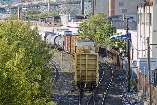
From Skillman Avenue, the structure of the Thomson Avenue viaduct is visible as it’s begins to roughly slouch back to the grade level of the surrounding streets. The Sunnyside Yard allows locomotive access to the New York Connecting Railroad, which connects Long Island to the rest of the continent via the Hell Gate Bridge. Sunnyside Yard continues all the way to Woodside, and sits on an astounding 8,500 feet footprint which consumes 192 acres and offers an unbelievable 25.7 miles of track. Historical records discuss the gargantuan task of reclaiming this swampy land for use as a rail yard, as seen in the snippet below.
from 1910’s “New York tunnel extension, the Pennsylvania railroad: description of the work and facilities, Volume 2“, courtesy google books
Originally, a swamp of 40 acres extended from the present location of Honeywell Street and Jackson Avenue to Thomson Avenue, and comprised a portion of the required Yard area; the remaining 168 acres within that area was rolling ground from 10 to 70 ft. above the swamp. Upon this high ground there were 246 buildings of all kinds, and these were purchased and torn down or removed. A view of the swamp in the early stages of the work is shown by Fig. 1, Plate XLV. A vegetable growth, of the nature of peat, from 1 to 4 ft. in thickness, formed the surface of the swamp, except in the bed of Dutch Kills Creek; beneath this there was a layer of mud, and in the bed of the stream a blue-black clay of the consistency of putty. As this muck and clay would move under the pressure of the filling over it, and produce waves of considerable height, it was specified in the contract that a blanket of earth about 4 ft. thick should be first placed over this part of the Yard area, in order to prevent this wave formation. This proved efficacious, except in one or two places, where, owing to unusual depth of filling, the wave formation broke through this covering and rose to such a height as to require excavation of the peat, muck, and mud, in order to secure proper track foundations. In the bed of Meadow Street, where the embankment was very high, the crest of one of the mud waves rose to an elevation of 28 ft. above the swamp.

– photo by Mitch Waxman
The naming of Thomson avenue has always been a bit of a mystery for your humble narrator. Skillman, for instance, was named for a farmer that supported the British during the American Revolution whose lands were confiscated by the victorious rebels (much like DeLancey over in Manhattan). Apparently, there were one or two LIRR and or Pennsylvania RR executives named Thompson- and certain older documents refer to this road as “Thompson Avenue” but this is a common typographic error which favors the more widespread surname.
There was a Thomson that was an important member of the Queens Chamber of Commerce during the 1920’s but the street dates back to the beginnings of Long Island City and must be named for someone earlier.
from nycroads.com
HISTORY OF QUEENS BOULEVARD: Originally called Hoffman Boulevard, Queens Boulevard dates back to the early years of the twentieth century, when the road was constructed as a connecting route between the new Queensboro (59th Street) Bridge and central Queens. In 1913, a trolley line was constructed from 59th Street in Manhattan east along the new boulevard.
During the 1920′s and 1930′s, New York City began a program to widen Queens Boulevard. The project, which was conducted in conjunction with the building of the IND Queens Boulevard subway line, widened the boulevard to 12 lanes in some locations, and required a right-of-way of up to 200 feet. Once completed, local and express traffic flows were provided separate carriageways.
quite convinced
– photo by Mitch Waxman
Recent financial setbacks and personal problems infect your humble narrator with a form of deep melancholy and a vast ennui. When such moments come upon me, there is a certain pizzeria in Greenpoint (Norman corner of Manhattan, near the train) whose offerings can be summed up best as: an actual and old fashioned “Brooklyn Slice”. On the day I spied this collection of rail cars at the so called “Bliss Tower” in DUGABO, I had scuttled forth from the rolling hillocks of my beloved Astoria in pursuit of one of these aforementioned slices, in an effort designed to brighten my mood.

– photo by Mitch Waxman
Errors and omissions mar my record when discussing the Rails, much to the chagrin of the knowledgable railfan community (whose helpful comments and corrections are always appreciated here at Newtown Pentacle). As such, what I can categorically tell you is that this a New York & Atlantic Locomotive, one of the 11 engine units which service the 269 miles of track operated upon by the Glendale based company in Brooklyn, Queens, and both Nassau and Suffolk counties. It shares much of its road with the passenger based Long Island Railroad, and NY&A’s distinctive emerald, white, and black engines are regularly observed around the Newtown Creek.

– photo by Mitch Waxman
Across the Newtown Creek Watershed, one encounters a landscape built for rail. Long abandoned track beds lie buried in inches of road asphalt, pointing the way to industrial giants long absent. Train stops orphaned from their purpose, spars and switches which were rudely severed to make room for modernity. All of it operated at street grade, and the remnants of the iron road are often the only tangible remains of great concerns and financial largesse. If you follow the right spar, you’ll discover that the NYPD Barricades unit was once Thypin Steel, or that LaGuardia Community College was once the Loose Wiles bakery and part of the Degnon Terminal.

– photo by Mitch Waxman
Within the communities which surround the Newtown Creek, a complaint often repeated concerns the presence of large numbers of trucks utilizing local streets in their quest to move goods from A to B. I had the privilege last year of attending a presentation by certain factions within the Port Authority that described a proposal which would eliminate several thousand truck trips a day throughout the City and over the George Washington Bridge, simply by shipping New York City’s garbage out to land fill utilizing locomotive rather than automotive means. Calculations about air pollution, road maintenance costs, and vehicular accident rates were presented at the time which compared rail quite favorably with truck based shipping.There was a maritime component to the plan as well, which was a bit hazy, but the train concept was spun gold.

– photo by Mitch Waxman
The shot above represents an NY&A Locomotive making a drop off of a customer in Maspeth near the ill fated St. Saviour’s church site, where they will uncouple a car or two for the unloading or loading of certain cargo. An unthinkable amount of trucks would be required to carry the same tonnage. The subject of Green Technology and “Greening New York” is often bandied about by many these days. Too much of the conversation, however, is “cocktail party environmentalism”- which sounds great but just isn’t practical on a policy level.
I’ve developed this funny notion, however, that the way forward is actually to re-imagine and re-invent the heaviest industry of them all.

– photo by Mitch Waxman
Rail infrastructure is what made Long Island City the factory of not just New York, but the entire world at the turn of the last century and multiple generations of capitalists and real estate interests founded vast fortunes because of the initial investment in it. Newtown Creek was the busiest waterway in North America, carrying more ship and barge traffic than the entire Mississippi for a time, and all of that maritime activity was fed by rail. Intermodal rail floats actually carried whole trains across the harbor to Manhattan, Staten Island, New Jersey and beyond. Imagine the benefits, in both individual wealth and environmental health, were we to try and save the future by looking for solutions in the past.
I’m still kind of forming this idea up for myself, but the key to it is containerization. More on this soon.
What do you, lords and ladies, think on the subject? Use the comments “Reply box” below, if you would like to start a conversation about it.
frenzied throng

– photo by Mitch Waxman
As you may have noticed from the little flickr badge on the right hand side of this page, it’s been a rather busy few days for your humble narrator. The Working Harbor Committee Tugboat races were a hoot, as always, but I’ve had to develop and deliver the shots in a somewhat timely manner- despite the annoyance of a computer system crash and a concurrent setback in my overall schedule.
Such is life.

– photo by Mitch Waxman
Some extremely exciting stuff is on the front burner right now, and October is looking to be another incredibly busy month. I can’t discuss any of it yet, but there will be several intriguing “events” which will be described to you in some detail in the coming weeks that I’m involved with.
Suffice to say- “Want to see something cool? Come with me, bring a camera and ID”.

– photo by Mitch Waxman
What does all this shadowy discussion and veiled promise have to do with shots of speedy trains and hidden trackbeds? Nothing at all, but this is a visual metaphor for what it feels like to be me at the moment.
A deer in the headlights, with a juggernaut hurtling ever closer.

– photo by Mitch Waxman
Just in case you were wondering- the trains are Metro North at Spuyten Duyvel, LIRR at Woodside and then DUPBO near Hunters Point, and Amtrak at Sunnyside Yards.
Catching up on the latest round of research, getting the next series of postings together, getting back on track. Expect regular but rather short posts for the next few days as I pull together the next session of this, your Newtown Pentacle.
sinister exultation

– photo by Mitch Waxman
It was a mid summer day in the city, July 24th to be exact, and the kind of weather which feels like one has been wrapped in hot barber shop towels was upon us. Occluded by a humid and occasionally precipitating mist, the burning thermonuclear eye of god itself was absent from the scene, but its influence was seen and felt by everyone here in this old section of Long Island City once known as the Degnon Terminal.
While marching down Skillman Avenue, your humble narrator could not help but notice a not so minor conflagration at the nearby Hunters Point rail station.

– photo by Mitch Waxman
It seems that an Amtrak engine, part of a problematic series of units employed by the rail conglomerate which are known as being given to sudden and unexpected events of immolation (or so my rail fan contacts tell me) had caught fire.
It was no surprise that the only camera on the scene was my own, as there are few in the Greater City who care for Queens and it’s burdens. FDNY (which does care about Queens) was on scene in great numbers, including members of several units which the Manhattan Political Elites had recently attempted to close due to budget issues.

– photo by Mitch Waxman
The engine seemed to be suffering from an electrical issue, which was anecdotally confirmed by one of the fire department commanders who was gracious enough to discuss the issue with me. Frustration was evinced by this veteran of New York’s never ending war on combustion that the spot which the engine had halted at was beyond the reach of his hose lines, and that they could only put band aids on the fire using hand held extinguishers.
There were literally dozens of fire team specialists in full tactical gear and several mobile command posts arrayed at strategic spots around the rail yard, but their ambitions were stymied by security fence and distance from hydrants.

– photo by Mitch Waxman
The commander, a lanky Irishman of solid build whose height easily passed the six foot mark, next informed me that their plan was to bring a second engine in from the nearby Sunnyside Yard complex and hitch it to the back of the train.
This second unit would then tow the burning engine and it’s passenger cars back to the titan Sunnyside Yard where both equipment and resources to combat the blaze would be available and abundant.
– photo by Mitch Waxman
Over the last few years, of course, your humble narrator has discovered or happened across every possible vantage point large enough to stick a camera lens through around the fenced off and often carefully obscured rail infrastructure which weaves through Western Queens and knowing FDNY’s plan, moved into a more propitious spot to record the event.
One must be careful when photographing trains and trackways, lest one accidentally step onto federal or state property and violate not just homeland security regulations but archaic laws which have persisted since the early days of the iron road, many of which carry mandatory sentences.

– photo by Mitch Waxman
The irony of these so called regulations, of course, is that whether it is because of expedience or carelessness, many of the employee entrances to the rail yard are often left ajar and unguarded. Was this to occur in Manhattan, there would undoubtedly be a series of broadcast and print media articles and investigations, followed by political posturing and a spate of sham regulations.
Since this is Queens, where the Borough motto should be “welcome to Queens, now go fuck yourself”, nothing will happen and the issue will never be discussed.

– photo by Mitch Waxman
The smell of burning insulation and plastics mixed freely with the humid air, and a monstrous storm was building in the milky sky. Far off thunder to the south indicated that a storm was coming. Your humble narrator, not too far from home however, persevered and dared the weather to do it’s worst.
Besides, the reason I was on Skillman Avenue in the first place was that I had to meet some guy to talk about a thing down here, and I caught this whole event simply because Queens wanted me to witness her burdens again.

– photo by Mitch Waxman
Perhaps it’s the impending anniversary of the September 11 attacks, or merely the normal late summer ennui which always darkens my mood, but the notion that the FDNY hasn’t got fire hose lines long enough to put out a train fire here- at so critical a spot in the infrastructure of the Megalopolis, and that an ordinary civilian like myself can so easily gain visual and physical access to all this- worries me.
In my travels across the concrete desolations of the river communities of North Brooklyn and Western Queens, there are so many of these unguarded and strategic points which have presented themselves that frankly- I don’t like taking the Train or Ferry anymore. When I point these vulnerabilities out to associates who are employed by government agencies or elected officials, they roll their eyes and tell me not to worry.
Same thing they used to do when I wondered out loud back in the 90’s about whether or not the United States had a system of air defenses protecting the defacto capitol city of North America.


