Posts Tagged ‘newtown creek’
quainter levels
It’s Anosmia Awareness Day, in these United States and the United Kingdom.
– photo by Mitch Waxman
For the curious – Anosmia is a loss of the sense of smell, which is apparently quite debilitating. One of my old buddies has always wondered about what smell “blindness” is called, and he’s been using “smeaf” for many years so I’m glad to report that there is – in fact – an actual term for it. Seriously though, imagine not being to taste your food or discern a gas leak or smoke – Anosmia is no joke and as serious as blindness or deafness. Of course, given the amount of time I spend at a certain superfund site which defines the currently undefended border of Brooklyn and Queens, Anosmia might be something of a boon. The loss of sensory data I’m currently experiencing is actually centered around touch, and a general numbness seems to be spreading across my skinvelope and ballooning out between my ears.
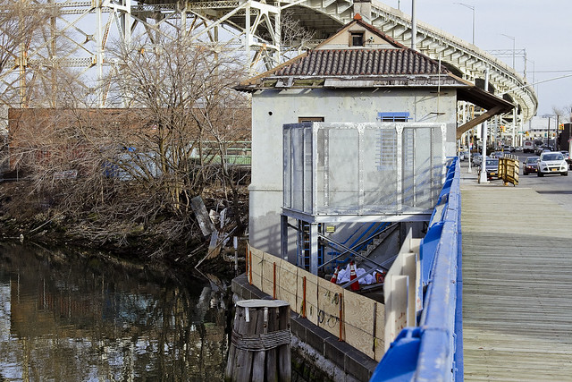
Pictured above is the fabulous Borden Avenue Bridge, a retractile wonder that the children of Queens would marvel at, would they elect to visit the Dutch Kills Tributary of the lugubrious Newtown Creek.

– photo by Mitch Waxman
Retractile means, incidentally, that the movable section of the roadway retreats away from its foundational piers, opening a spot for maritime traffic to pass through. In the shot above, you can see the spot which accepts the retractile section. There’s locomotive style rails running across the spot, which carry the truss. Famously, there’s only two retractile bridges in NYC, with the other one (which is decidedly smaller in scale and older in design) spanning the Gowanus Canal at Caroll Street. I guess that today is vocabulary day, at this – your Newtown Pentacle.

– photo by Mitch Waxman
The section of the Long Island Expressway seen above is referred to as the Queens Midtown Expressway by officialdom, and it’s some 106 feet up from the street to its road deck. It opened in 1939, and feeds it’s traffic flow into the nearby Queens Midtown Tunnel (also 1939) leading to Manhattan. A conceit often I’ve often used at spots like this, all around NYC, is to call this “The House of Moses” for NYC’s master builder Robert Moses. The tunnel and QME weren’t projects he started, but they are projects that Moses bullied his way into and took over – as a note. Robert Caro didn’t call Moses the “Power Broker” just to be snarky.

– photo by Mitch Waxman
One of the reasons that I hate all of you equally is exemplified by this all too common site at the littoral edge of Dutch Kills. I’m the guy who wads up personally produced garbage in his pockets and carries it until encountering a proper trash receptacle, so realize that this is a pet peeve of mine – but what the hell is wrong with all of you? You don’t just discard things like cups and food wrappers or plastic bags out of your car window as you move along, do you? Quite obviously, many do. I see this every where I go in NY harbor.
How about you? Shame on all of us for this.

– photo by Mitch Waxman
There seems to be some signs of life at this long vacant property along Dutch Kills – the former Irving Iron Works factory. Part of their site has had a cinder block wall erected. Notice that it was built from another installation of blocks which had been literally graffiti’d and that now it’s just a hodge podge of random colors. That’s kind of cool actually.
I’ll keep an eye out.
“follow” me on Twitter- @newtownpentacle
baffling lack
It’s Setsubun Day, in the nation of Japan.

– photo by Mitch Waxman
As described in yesterday’s post, the 21st of January was a pretty foggy day, which is something I consider pretty. One made it a point of visiting several distaff locations around Long Island City to capture the scene. The shot above is something that all of you reading this will be able to personally enjoy sometime in the very near future, when the Smiling Hogshead Ranch expands its operations up to the abandoned trackway of the Montauk Cutoff.
The photo above depicts the most photogenic of NYC’s subway lines – the IRT Flushing, or 7 line – exiting the elevated tracks of the Court Square Station and traveling on its way to Manhattan.

– photo by Mitch Waxman
One spent a bit of time up on the tracks, as I ran into an old friend while making my way up there and we spent some time catching up while I waved the camera around. The cutoff is brutally bare during the winter months, as all of the self seeded vegetation surrounding it is deep in hibernation. During the warmer months, it’s positively verdant up here – an island of green amidst the concrete devastations of Western Queens.

– photo by Mitch Waxman
Disturbingly, the Queens Cobbler seems to have visited the Cutoff recently, leaving behind one of the totemic “single shoes” signaling that he or she was here. The “Queens Cobbler” is the name I’ve assigned to a likely serial killer who claims human lives all around the Newtown Creek watershed, leaving behind a single shoe to announce that their latest hunt has been successful.
Someday, the NYPD will happen upon a hidden warehouse room in LIC or Maspeth filled with footwear and gore, and on that day – the metaphorical and literal “other shoe” will truly fall. Back next week with something completely different at this – your Newtown Pentacle.
“follow” me on Twitter- @newtownpentacle
modern matters
It’s Street Children’s Day, in the Republic of Austria.
– photo by Mitch Waxman
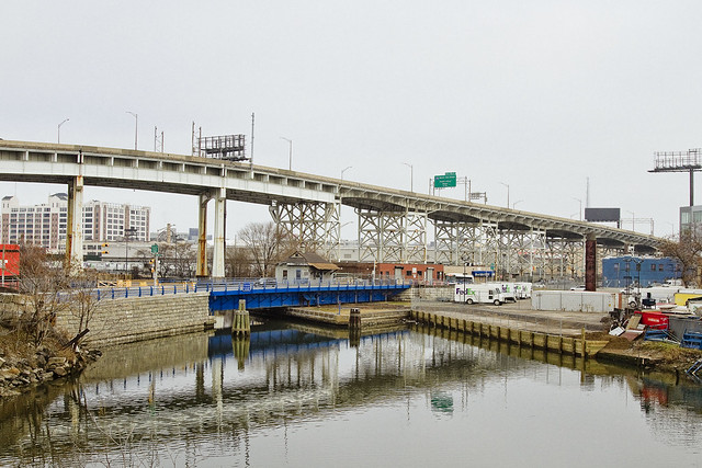
Dutch Kills, a tributary of Newtown Creek which abruptly turns north off the main channel three quarters of a mile east of the East River, is entirely contained within Long Island City. It’s crossed by five bridges – the LIRR bridges DB Cabin and Cabin M, the Borden Avenue Bridge, the Queens Midtown Expressway truss, and the Hunters Point Avenue Bridge. Dutch Kills, like all of Newtown Creek’s tributaries and the main channel itself, is lined with a toxic sediment referred to as “Black Mayonnaise.” This sediment is composed of coal tar, petroleum and refining byproducts, industrial waste of various provence and typology, as well as human excrement deposited by NYC’s open sewers.
At its northern terminus, Dutch Kills is across the street from a CUNY college and several charter schools serving high school and junior high school aged kids. One of the most significant build outs in recent real estate history is happening less than a quarter mile from that spot, along LIC’s Jackson Avenue in an area referred to as “Court Square.”

– photo by Mitch Waxman
Due to a non functioning railroad swing bridge at Dutch Kill’s junction with Newtown Creek’s main channel, there is absolutely zero maritime industrial activity along the tributary. The bulkheads along its reach generally date back about a century, to a massive “improvement” conducted around the time of the First World War which saw the marshes and swamps it fed drained and both the Sunnyside Yards and the Degnon Industrial Terminal constructed.

– photo by Mitch Waxman
The streets surrounding Dutch Kills offer fleeting glimpses of the waterway, and many of them are not City streets at all but “railroad access roads” owned by the MTA. You can almost always smell the waterway before you can see it, and whereas I can tell you a few spots to access the water, none of these are “legal” and all involve trespass of private or government property. You can legally observe it from the Borden Avenue or Hunters Point Avenue bridges, however.
At it’s terminus – or “turning basin,” there are two abandoned oil barges rusting and rotting away into the water.

– photo by Mitch Waxman
Illegal dumping, the native art form of the Borough of Queens, is practiced hereabouts with relish and abandon. The DSNY garbage bin in the shot above appeared on 29th street back in November, and I’ve been watching it steadily fill up and overflow. DSNY doesn’t seem to remember where they put it, as I haven’t seen it empty since the day it arrived.

– photo by Mitch Waxman
Amidst the sheens of oil and grease you’ll observe on Dutch Kills, which are both historic and newly spawned, there are what the NYC DEP would describe as “floatables.” That’s government code for garbage that’s either been flushed or has been swept into the sewer grates on every street corner in NYC. In the case of Dutch Kills, the “sewer shed” that feeds these floatables into it extends all the way to East Elmhurst and Woodside to the east, Sunnyside and Astoria to the north, and the rapidly growing Long Island City which Dutch Kills is a part of.
The sewer plant that handles this burgeoning area was opened in 1931, and Fiorello LaGuardia cut the ribbon to open it.

– photo by Mitch Waxman
There is going to be a meeting tomorrow, the latest of many, of the Newtown Creek Community Advisory Group (CAG) on the first of February. If the shot above looks good to you, and you’d like to see more of the same – don’t come. If you care about not having a billion and a half gallons of raw sewage a year spilling onto mounds of poisonous and century old industrial waste, do come. Pipe up, we need voices and perspectives from outside the echo chamber.
Details on the meeting – time, place, etc. – can be accessed at this link. We could really use some Queensican bodies and voices in the room.

– photo by Mitch Waxman
As evinced by the corpse pictured above, life has actually begun to recolonize this waterway in recent years. The presence of higher mammals hereabouts speaks to an ecosystem that is beginning to recover from centuries of industrial and municipal abuse. Of course, nothing is going to save a raccoon from getting ground into hamburger by the wheels of a semi truck.
At Newtown Creek Alliance, we’ve been cataloging and observing for a while now. There’s more than seventy individual species of birds for instance – including Great Blue Herons and Ospreys – living along the lugubrious Newtown Creek. Their presence speaks to a growing population of prey animals (fish) present in the water column, and to a broader environmental recovery happening along this industrial waterway at the literal center of NYC.
“follow” me on Twitter- @newtownpentacle
awestruck party
It’s Fred Korematsu Day of Civil Liberties and the Constitution, in the states of California and Virginia.

– photo by Mitch Waxman
Throw your hands in the air, like you just don’t care.
That’s what most of the residents of Queens do when the subject of Newtown Creek comes up. That’s Brooklyn’s problem, not ours. Then I tell them about how the decisions affecting Queens are being made by the “transplant hipsters of Brooklyn” whom they revile, and that whereas Brooklyn is going to be getting new parks and other municipal goodies out of this Superfund thing… Queens is largely being left out of the equation. That riles the north shore peeps up a bit, but they still don’t get involved. Since the people of Queens are disinterested, so is elected officialdom.
Fish, or cut bait. If neither, then get out of the way.

– photo by Mitch Waxman
I’ve always chalked it up to topography. If you’re in East Williamsburg, or Greenpoint, Newtown Creek is part of your life whenever you open your window. The Brooklyn, or south side, of the Newtown Creek hosts residential properties which are literally across the street from the bulkheads. The Queens, or north side, communities generally have a buffer zone of industrial buildings and highways separating them from the water. Newtown Creek is a half mile from residential Sunnyside.
In Queens, they complain about truck traffic, hipsters, and gentrification.

– photo by Mitch Waxman
We are at a critical juncture, Newtown Creek wise. The science from all parties involved in the cleanup is beginning to be compiled. The DEP, in particular, is about to lock itself into a quarter century long program of construction and strategic maneuvering. Around a year or so from now, the oil and gas people will be doing the same and committing to a strategic course.
Ultimately, EPA will be doing the same thing and deciding on their course of action, but given the current political crisis in the Federal Government there is no real day to day guarantee that there will be an Environmental Protection Agency which resembles the current one.
What do clean and accessible waterways mean to President Trump and Steve Bannon?

– photo by Mitch Waxman
There is going to be a meeting, the latest of many, of the Newtown Creek Community Advisory Group (CAG) on the first of February. If the shot above looks good to you, and you’d like to see more of the same – don’t come. If you care about not having a billion and a half gallons of raw sewage a year spilling onto mounds of poisonous and century old industrial waste, do come. Pipe up, we need voices and perspectives from outside the echo chamber.
Details on the meeting – time, place, etc. – can be accessed at this link. We could use some Queensican bodies in the room.

– photo by Mitch Waxman
The shots in today’s post were gathered on the eastern side of the Newtown Creek, in Ridgewood and Maspeth. The environmental conditions in these industrial buffer zones are off the charts bad. You don’t have to look far to find dead birds, rats, all sorts of unlucky critters who innocently wandered in here. It wasn’t the Creek that killed them, it was the hundreds of heavy trucks.
As a note to Maspeth and Ridgewood residents – this is where the trucking you complain about comes from.

– photo by Mitch Waxman
There’s a vision of what the future can hold for generations unborn that we have all been working for and towards. An industrial canal which also welcomes recreational boaters. An industrial canal which was the most significant job creation engine NYC has ever seen and which can be so again. A mixed use waterway in which business and the ecology operate hand in hand.
Ever heard of the “Maspeth heat island effect”? It’s the reason why your energy bills are so high during the summer, and it’s caused by the complete lack of green space in these industrial neighborhoods, which causes temperatures hereabouts to be ten or more degrees warmer during the summer than in surrounding communities. Is that Brooklyn’s problem? What about the trucks, or the garbage trains?

– photo by Mitch Waxman
This post is meant to scold, and compel. Get involved, whatever your point of view is. The political elites of our City will not care unless you care.
“follow” me on Twitter- @newtownpentacle
veritable ossuary
It’s National Pie Day, thanks to the American Pie Council, in these United States.

– photo by Mitch Waxman
People think I’m exaggerating, all the time, about the poison earth surrounding my beloved Creek.
They say it can’t possibly be as horrible as I say it is along the Newtown Creek. Thing is, they’ve never been here during the workday, but instead visited on some nice Saturday in July. To understand the horror of it all, you need to see it, smell it, experience it – personally. That’s why I do my walking tours, but the walking routes I take the public out on are as safe a set of paths as you can possibly scout through the Newtown Creek Industrial Districts. As a note – whenever I’ve got a regulator or political official out with me, I take them to places which are best described as “hell.” I figure that since these officials, and their forebears, are pretty much responsible for letting all of this happen in the first place that they should experience it in toto.
Before I continue… should you decide to come and explore these areas for yourself, I accept zero responsibility or liability for you doing so. I’m telling you point blank, stay away from the borderland of industrial Bushwick and Ridgewood, and the corner of Scott and Randolph in particular. You can easily get hurt, or worse. It’s Mordor up in here, with giant trucks whizzing around, which scare away rodents of unusual size – critters who are oddly used to being out in the daylight. There’s a whole set of rules around here that you aren’t necessarily privy to either. It’s too late for me, but save yourself.
Stay away from the Scott Avenue footbridge zone, yo, this shit’s nasty.

– photo by Mitch Waxman
That’s the Scott Avenue Footbridge pictured above, incidentally, which provides one with an interesting vantage point to observe the area from. It’s a bit like a hunting stand providing an elevated POV in the middle of some savanna. The bridge itself is typical of the Long Island Railroad footbridge model you’ll find all over Queens. A steel and concrete structure that provides pedestrian egress high over one of their train lines. In the case of this particular bridge, which is quite dilapidated I would add, the train tracks it overflies are the Bushwick Branch of the LIRR.

– photo by Mitch Waxman
Almost every other time that I’ve stood on this footbridge during the last decade, the New York and Atlantic freight operation has had literally hundreds of rail cars lined up along it – which compose the so called “Garbage Train.” Like all of the sections of North Brooklyn which touch the Newtown Creek, gentrification is under way in Bushwick. Large numbers of people are moving in just a few blocks east of here. Flushing Avenue’s intersection with St. Nichols is just a few blocks east of here – the heart of the “Brooklyn thing” which the real estate guys are so into.
Notably, the real estate guys will sometimes refer to this area as Williamsburg, rather than Bushwick or East Williamsburgh, to prospective clients. Eventually, “Williamsburg” will extend into Nassau County.

– photo by Mitch Waxman
This little neighborhood of blue collar laborers, however, is rife with hazard for the unwary. As has often been mentioned, the “working guys” have a protocol for handling themselves around heavy equipment and such, and not being privy to its mores makes you quite vulnerable to random accident. For instance – never, NEVER, cross in front of a piece of equipment – whether it truck, forklift, whatever – without stopping and waiting for the operator to acknowledge you and wave you on. Can’t tell you how many people I see just darting in front of construction equipment.
Also, advice offered to everybody crossing Northern Blvd. back in Queens is to stand behind a pole or something while you’re waiting for the light to change. Same thing applies in Queens Plaza, and the western extent of Queens Blvd. which feeds into it.

– photo by Mitch Waxman
There’s a waste transfer station, or twenty, hereabouts. The garbage guys will tell you “it’s got to go somewhere,” and in the case of the Newtown Creek watershed and surrounding industrial districts, about a third of New York City’s garbage comes here every day. Trucks come in full and leave empty, leaving behind tons and tons of construction debris, recyclables, and putrescent waste.
Have I ever mentioned that I don’t seem to get sick that much, almost as if my immune system is all jacked up and running at maximum speed for some reason?

– photo by Mitch Waxman
Looking north-west (ish) you’ll notice the everpresent Sapphire Megalith of Long Island City.
One navigates about the Newtown Creek via triangulation of position between the Freedom Tower in lower Manhattan, the Empire State Building in midtown Manhattan, and the Sapphire Megalith in LIC.
To wit – if you want to go the waterfront of the East River in LIC from Ridgewood or Maspeth, find a spot where the Empire State and the Megalith seem to line up and head in that direction. Going to Astoria? Keep the Megalith and Empire State on the left. Williamsburg? Freedom Tower at center with Empire State on your right and the Megalith behind you. When they finish all that horrible construction in LIC, I’ll have to decide on a new landmark, as the megalith won’t be the tallest building in Queens much longer.

– photo by Mitch Waxman
Close to the corner of Metropolitan Avenue and Scott is a NYC Department of Public Works access – or manhole – cover embedded in the sidewalk. DPW is one of the many agencies that were compressed into the DEP back in 1983, and out here in North Brooklyn, DPW was the inheritor of the City of Brooklyn’s 19th century sewerage projects which were all consolidated into the City of Greater New York’s holdings in 1898. It’s an intersecting sewer, which my “understanding of” indicates that below will be found some vault like structure that leads into a big pipe on one side, which is fed by a series of smaller pipes located on the other – but I don’t know that because I haven’t been down there.
The smaller pipes do feed in from upland sources, and in the case of this spot, those sources can be as far away as East New York and Canarsie. That’s something I actually do know since I’ve argued about it with officialdom.
The big pipe empties into the East Branch of the Newtown Creek across the street, at a “the size of a semi truck trailer” open sewer that’s called “Combined Sewer Outfall NC-083.” This CSO pollutes the water here with some 586 million gallons of untreated sewage a year, which is a debatable and out of date number that’s attibutable to official sources. It’s amongst the largest of the 400 CSO’s in the City, just as a note. A major contributor, roughly 20%, to the approximately billion and half gallons of raw sewage that flows into Newtown Creek annually, can be accessed below this hatch.

– photo by Mitch Waxman
BPF? A water main cover which is close proximity to the “intersecting sewer” hatch featured above, the “BPF Water” thing torments one such as myself. Does “BP” stand for “Borough President,” and if so, “Borough President” what? Is it “Brooklyn” or something else?
Arghhhhh. Something which I don’t know every detail of around the Creek? I’m a complete failure, and now everybody knows it.
Sometimes, if I didn’t make this “job” of mine up out of thin air, I’d complain about how little I get paid for the sheer angst of not knowing what the legend on some random water main cover means.

– photo by Mitch Waxman
Tittering laughter was heard, carried by an easterly breeeze, as one approached Metropolitan Avenue.
My theory is that some inhuman thing with a three lobed burning eye – housed in the cupola of a sapphire megalith found miles away – made this sound as it giggled at the frustrations of a humble narrator.
Back tomorrow, with something completely different at this – your Newtown Pentacle.
“follow” me on Twitter- @newtownpentacle


