Archive for the ‘Greenpoint’ Category
abominations and blasphemies
Fight.
– photo by Mitch Waxman
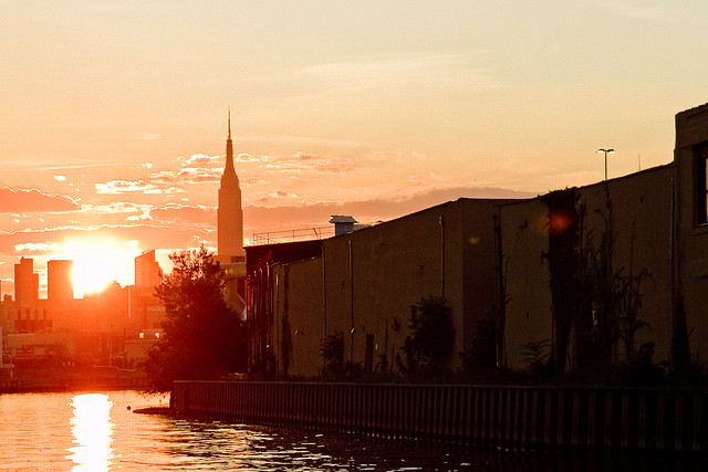
Gaze upon the Newtown Creek. Currently an EPA Superfund site. Is it going to be one for long? Will there be an EPA this time next year? Would this be a good place, instead, to site a black and gold casino? I’ve been considering the Trump victory, and its implications. I’ve been reading a bunch of stuff written by people like myself, who thought the Presidential Election would be a logical slam dunk in favor of the more qualified candidate. All of us “lefties” have had to admit that we were wrong in our assumptions that our fellow Americans would actually vote in their own economic and cultural interest.
C’Est la Vie.
– photo by Mitch Waxman
Early thoughts on the “new normal” involve trying to take advantage of it, which is the American Way. Should Mr. Trump make good on his promise to build a wall across the narrow part of the North American Continent, rebar and Portland Cement futures look like they’ll be a promising investment. Also, I’m planning on finding out who the leading players in immigration law are, and whether or not they are publicly traded companies.
It’s the EPA thing that we’re all talking about on the Creek, I would mention.
– photo by Mitch Waxman
It’s going to be a very interesting few years, I think.
Mainly, because the Republican Congress is likely going to eat the new President for lunch. Those are shark infested waters down in the District. Let’s face it though, all that Donald Trump actually wants to do stand in front of the cameras while cutting the ribbon on all the “bridges to nowhere” and crony projects they’re going to be building.
The game just continues.
– photo by Mitch Waxman
Personally, and as I’ve often opined – National Politics is way above my pay grade. I’ve got other, more decidedly local problems to worry about.

– photo by Mitch Waxman
One has been on a Newtown Creek vacation for the last month, and it’s time for me to get back on the job.
“follow” me on Twitter- @newtownpentacle
suddenly lost
Getting high in Greenpoint, Brooklyn.

– photo by Mitch Waxman
Last week, one of the environmental projects underwritten by GCEF (the Greenpoint Community Environmental Fund) opened to the public at Brooklyn’s 520 Kingsland Avenue, alongside that loathsome exemplar of municipal neglect known as the Newtown Creek. In this case, the project is a green roof installed on top of a movie studio, specifically one of the production facilities owned and operated by the Broadway Stages company which is partially housed in a series of formerly industrial locations around Greenpoint and Long Island City. Broadway Stages has been buying up a LOT of property along the Creek in recent years.
Well, I guess the location is still industrial, it’s just a different kind of industry – entertainment rather than petrochemical. At any rate, 520 Kingsland Avenue is a few stories above the flood plain and whilst up there and on site, I got busy with the camera. You’ve seen this point of view before, incidentally – in a 2016 post where I told you about Brooklyn’s invisible flame back in June.

– photo by Mitch Waxman
Can’t really talk about it quite yet, but let’s just say I’ll be able to take you up there in a couple of weeks on a couple of free tours. I’ll supply the link as soon as it’s public. The green roof at 520 Kingsland was designed with butterflies, of all things, in mind. Saying that it’s a pretty interesting space with neat little walkways weaving through plantings, and there are incredible views of the surrounding industrial zone to check out.
That’s part of Metro Fuel’s truck fleet in the shot above, for the curious.

– photo by Mitch Waxman
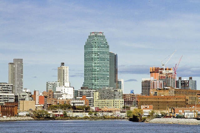
The real stunners, amongst the many points of view available from 520 Kingsland Avenue, are the ones in which the shining city of Manhattan provides the backdrop. This sort of urban pornography is possible due to two reasons: one is that the Greenpoint Landing Project is just kicking into gear, so the POV isn’t blocked by forty story residential palaces yet; the other is that the surrounding area is all 19th century landfill which is both low lying and quite flat.
This POV is looking due west from the 520 Kingsland Avenue rooftop, incidentally.

– photo by Mitch Waxman
Northwest POV, gazing across the lugubrious Newtown Creek in the direction of Long Island City’s Hunters Point section.
In the distance, you’ll notice the red and white banded smokestacks of the “Big Allis” power plant at 36th avenue in the Ravenswood section. The Citi building megalith, that sapphire dagger jammed in the heart of the place at Jackson Avenue’s intersection with Thomson Avenue, used to be the only large scale building in the area.
As an aside, a few years ago some group of urban planners/art fucks from Pratt University proposed Big Allis’s red and white stripes to me as a branding element for the western Queens waterfront. I had to inform them how we residents regarded the presence of an enormous power plant operating along our waterfront that serves Manhattan’s needs, and that it wasn’t exactly a popular symbol, locally speaking.

– photo by Mitch Waxman
The singularity of the Citi megalith has, of course, changed. The pace of real estate development in the last few years has been frenetic in LIC, as evinced in the shots above and below. Sometimes, in order to really take it all in, you need to leave Queens entirely – just to gain some perspective.
Funnily enough, this is what I usually say about Manhattan – the best part of “the City” is being outside of it and witnessing the shield wall of buildings from without. An inhuman scale landscape like Manhattan’s can’t be properly observed while you’re within the oppressive shadows of its canyon walls.

– photo by Mitch Waxman
That white truss structure at center of the shot is the Long Island Expressway, which rises over Newtown Creek’s Dutch Kills tributary from its beginnings at the Queens Midtown Tunnel. Dutch Kills intersects with the main body of Newtown Creek about 3/4 of a mile back from the East River, and heads inland for the better part of a mile. The LIE traffic up on that truss bridge is flowing 106 feet over the water. The far right hand side of the shot above shows the construction going on at the intersection of Jackson Avenue and Queens Plaza, on the former West Chemicals Company site. Moving left, the rest of the construction is occurring along Jackson Avenue at Purves, Dutch Kills Street, and so on.
All of it is high end residential, incidentally, except for that squamous curvy faced one directly to the left of the orange one. That’s an office building which the NYC Dept. of Health has based itself in nearby Queens Plaza.

– photo by Mitch Waxman
One of my little adages, which I gleefully relate on my walking tours of the area, is a facet of NYS law – it dictates that if you were about to buy a home which is known to be “haunted by a ghost” by the current owner and or the surrounding community – the haunting needs to be disclosed before closing the sales contract.
If you’re buying a property that used to be a chemical factory, or a copper refinery, or some other heavy industrial pursuit that rendered the site a “brownfield” – you are under no obligation to disclose the environmental history to a buyer, however.
When you meet newer residents of LIC’s Tower Town or Brooklyn’s Greenpoint, and mention a nearby Federal Superfund site defined as “Newtown Creek” – they say “What’s that?”
Upcoming tours and events:
“First Calvary Cemetery” walking tour
with Brooklyn Brainery, Saturday, October 8th from 11:00 a.m. to 1:00 p.m.
Click here for tickets.
“follow” me on Twitter- @newtownpentacle
jaundiced eye
Just a short one today.

– photo by Mitch Waxman
Spotted this Checker Cab parked on Greenpoint Avenue in Brooklyn not too long ago. Checkers used to be the standard model taxi cab in NYC, back in the days of leaded gasoline. Getting my notes together for tonight’s sunset boat tour with Working Harbor Committee on the East River, so apologies for the lack of a proper post today, but a humble narrator has to be buttoned up when narrating humbly onboard a boat to hundreds of people.
Come with? Tix link directly below.
Upcoming tours and events:
“Brooklyn Waterfront – Past & Present” boat tour
with Working Harbor Committee, Thursday, September 15th from 6:00 to 8:00 p.m.
Click here for tickets.
“13 Steps around Dutch Kills” walking tour
with Atlas Obscura, Sunday, September 18th from 11:00 a.m. to 2:00 p.m.
Click here for tickets.
“First Calvary Cemetery” walking tour
with Brooklyn Brainery, Saturday, October 8th from 11:00 a.m. to 1:00 p.m.
Click here for tickets.
“follow” me on Twitter- @newtownpentacle
unequal heating
Creek Week concludes, in today’s post.
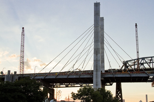
– photo by Mitch Waxman
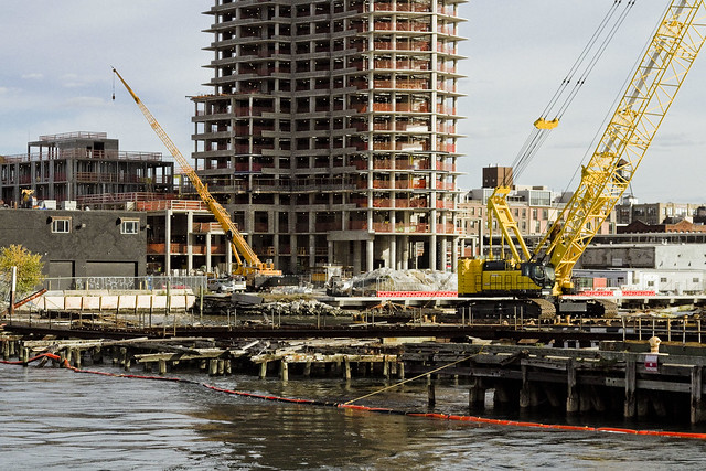
That’s the Kosciuszcko Bridge replacement project pictured above, with the 1939 Robert Moses model bridge providing a backdrop to the under construction cable stay model. That’s the Brooklyn side, for the curious. This is a $1.2 billion replacement effort, “fast tracked” by Governor Cuomo, which is intended to replace what’s considered to be the most dangerous bridge in New York State – which happens to carry hundreds of thousands of vehicle trips a day as the Brooklyn Queens Expressway runs across its 2.1 mile long structure (along with its approaches).
– photo by Mitch Waxman
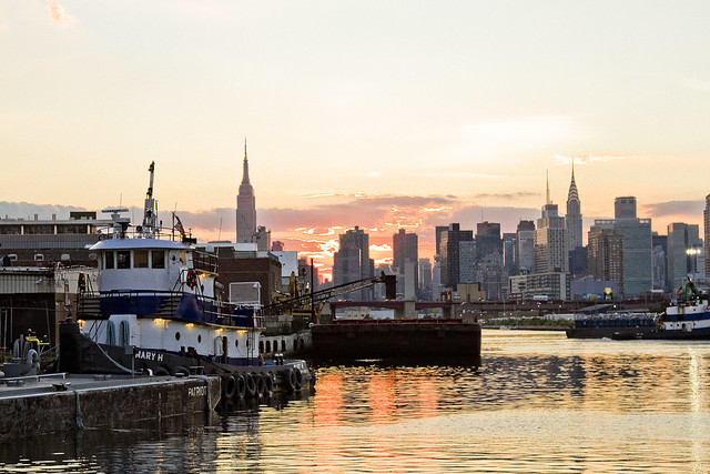
These shots were captured while onboard a NY Water Taxi hired for the evening by the Open House NY organization, and my colleague T. Willis Elkins and I were onboard to represent Newtown Creek Alliance and narrate to two sold out crowds. The second trip was heading back out from the Newtown Creek towards the East River just as sunset was occurring, and as always – Newtown Creek was and is a visual spectacular.
– photo by Mitch Waxman
One has been trying to capture as many angles and shots as possible of the old Kosciuszcko Bridge for a couple of years now, simply because within the next 24-36 months it will have been eradicated from common memory.
This whole “Newtown Creek Historian” business isn’t just about revealing the past, it’s about leaving behind a visual record for those who haven’t been born yet about what the place looked like during its superfund and early 21st century transformational period.
– photo by Mitch Waxman
I’ve mentioned it before, but the plan which the State DOT has put forward is that once the eastern side of the new bridge is complete, they are going to reroute the BQE onto it. Then, they’re going to demolish the 1939 model, and in its footprint, build the western section of the new cable stay bridge. The great news about that is that there is going to be a pedestrian and bicycle path on the western side of the bridge.
One looks forward to walking the camera across, and getting aerial shots from up there.
– photo by Mitch Waxman
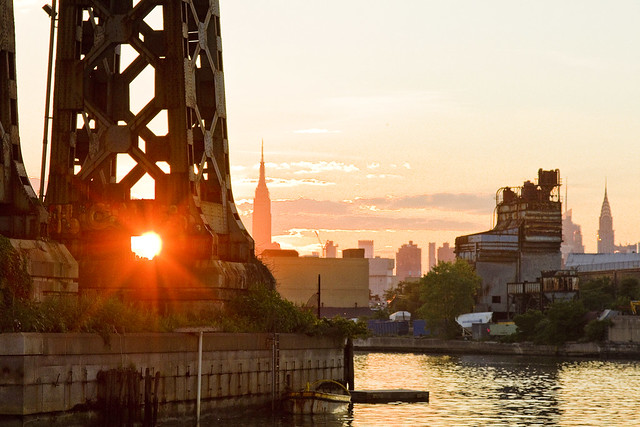
The burning thermonuclear eye of God itself was setting in the west as our NY Water Taxi navigated back towards the East River. That’s Blissville in Queens on the right hand side of the shot above, and the former location of not just Charles Pratt’s “Queens County Oil Works” but just about the very spot where the first large scale oil refinery in the United States – Abraham Gesner’s “North American Kerosene Gas Light Company” was founded.
– photo by Mitch Waxman
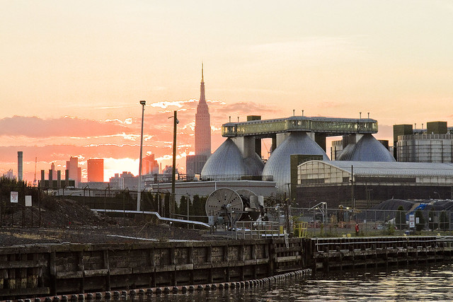
On the Brooklyn or Greenpoint side of Newtown Creek, the former home of the Standard Oil Company of New York and birthplace of what would be one day known as Mobil Oil is closest to the camera, which are now the ExxonMobil Greenpoint Remediation Project properties at 400 Kingsland Avenue.
Sitting on part of the former oil company properties in Greenpoint is the NYC DEP’s Newtown Creek Wastewater Treatment Plant, largest and newest of NYC’s 14 sewer plants.
– photo by Mitch Waxman
DUGABO – or Down Under the Greenpoint Avenue Bridge Onramp – is the heart of petroleum country on Newtown Creek. Greenpoint Avenue heads west into Brooklyn, terminating at the East River at Transmitter Park, whereas it continues into Queens and once having crossed Queens Blvd. – it transmogrifies into Roosevelt Avenue and continues all the way out into Flushing.
– photo by Mitch Waxman
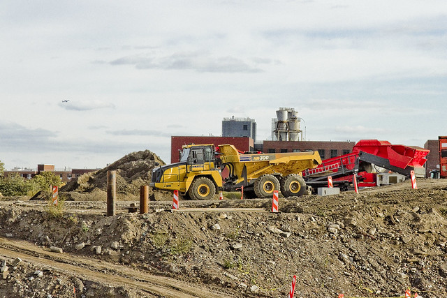
From a maritime industrial point of view, the DUGABO area surrounding the Greenpoint Avenue Bridge is probably one of the busiest sections of Newtown Creek in the 21st century. SimsMetal and Allocco Recycling host regular tug and barge traffic, as does Metro fuel.
In the distance is the Pualski Bridge and the towers of the Shining City of Manhattan.
Upcoming Events and Tours
Saturday, August 6th, 2:00 p.m. – 4:00 p.m. –
Insalubrious Valley Walking Tour,
with NY Adventure Club. Click here for more details.
Sunday, August 14th, 11:00 p.m. – 1:00 p.m. –
Calvary Cemetery Walking Tour,
with Atlas Obscura. Click here for more details.
Sunday, August 21, 11:00 a.m. – 1:00 p.m. –
Poison Cauldron Walking Tour,
with Atlas Obscura. Click here for more details.
“follow” me on Twitter- @newtownpentacle
prodigious grasp
From high atop Greenpoint.

– photo by Mitch Waxman
The eight anaerobic digester eggs of the Newtown Creek Wastewater Treatment plant in Greenpoint gather a lot of attention. At the very top of these stainless steel vessels are catwalks which connect them together into two groups of four. You’re something like 140 feet up, and the entire assembly is wrapped in blue green glass.
The shot above looks southwest, across Brooklyn.

– photo by Mitch Waxman
On top of each of the individual eggs, you’ll find all sorts of plumbing and control mechanisms. There’s also a view port through which you can observe the bubbling sludge as its “cooked” by the biological processes within.

– photo by Mitch Waxman
Just for perspective, here’s a look at the things from outside the plant. The shots in today’s post were captured from the catwalk closest to the camera.

– photo by Mitch Waxman
It’s actually fairly challenging to shoot from the catwalks, as that green glass screws around with the camera’s light meter and sensors. There’s also reflections to deal with, which you’ll see a few of in these shots, and needless to say – the glass ain’t exactly super clean.

– photo by Mitch Waxman
Looking down at Kingsland Avenue and Allocco Recyling, over the methane jets which burn off the mephitic gas produced by the digester eggs.

– photo by Mitch Waxman
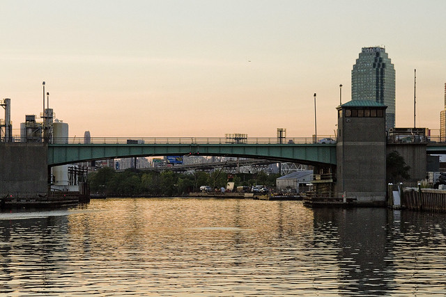
Looking towards the Greenpoint Avenue Bridge, towards Blissville in Queens.

– photo by Mitch Waxman
Looking west, over the Newtown Creek Wastewater Treatment Plant’s grounds, towards Manhattan.

– photo by Mitch Waxman
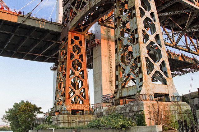
Another perspective on the Greenpoint Avenue Bridge, this time with Blissville’s former Van Iderstine property, Calvary Cemetery, and the Kosciuszcko Bridge at the Maspeth border in frame.

– photo by Mitch Waxman
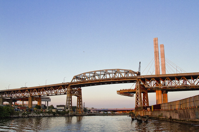
The Kosciuszcko Bridge replacement project is in the background, with a “green asphalt” plant and a Waste Management transfer station in the fore. That’s Newtown Creek flowing on the right side of the shot.

– photo by Mitch Waxman
A wider view of the scene, this time you’ve got the ExxonMobil 400 Kingsland Avenue property in view as well.

– photo by Mitch Waxman
Tomorrow – Creek Week continues, but from an entirely different perspective.
Upcoming Events and Tours
Wednesday, August 3rd, 6:30 p.m. – 8:30 p.m. –
Glittering Realms Walking Tour,
with NYC H2O. Click here for more details.
Saturday, August 6th, 2:00 p.m. – 4:00 p.m. –
Insalubrious Valley Walking Tour,
with NY Adventure Club. Click here for more details.
Sunday, August 14th, 11:00 p.m. – 1:00 p.m. –
Calvary Cemetery Walking Tour,
with Atlas Obscura. Click here for more details.
Sunday, August 21, 11:00 a.m. – 1:00 p.m. –
Poison Cauldron Walking Tour,
with Atlas Obscura. Click here for more details.
“follow” me on Twitter- @newtownpentacle


