Archive for the ‘Pulaski Bridge’ Category
cheering illusion

– photo by Mitch Waxman
Long island City, as we know it, was all about trains. Everywhere you go, tracks are. Despite this, the entire modern place is defined by it’s relationship to the automobile, which seems to have been the guiding principle behind much of its development in the middle 20th century- pull up the tracks and lay asphalt down for trucks. For those of you who might have seen me tagging along on one of Kevin Walsh’s audacious 2nd Saturday tours this summer, this will be a familiar refrain, but one of the things I’ve been going on about for the last several months is the “Locomotive City” versus the “Automotive City”.

– photo by Mitch Waxman
What I mean is that during the 19th and early 20th century, the place was set up and designed around access to rail based transportation rather than automotive needs. It’s why it’s so hard to park in LIC, except if you’re driving a train. 50 years ago, it was still not an uncommon or remarkable thing to see a Locomotive engine making its rounds at grade level around these parts, before everything switched over to truck and car based transport and the spars were cut.
This “locomotive city” had its own set of problems, of course, noise and pollution and accidents and all that- but the “automotive city” of the latter 20th century which we are all so familiar with is no picnic either. At least the earlier incarnation of the place was a lot more efficient.

– photo by Mitch Waxman
As regular readers of this, your Newtown Pentacle, know- I’m kind of an infrastructure geek. One of my favorite topics are the sewers after all, and anyone who has accompanied me on a walk through LIC has had to endure me running over to a construction site and waxing rhapsodically about the layer cake of street systems which are revealed whenever workmen have dug their way down to perform maintenance or repairs on some buried subsystem.
In a single vertical yard, you will see asphalt, cement, belgian block cobblestones, macadamized or creosote treated wood blocks, oil saturated compacted earth- all the way down to the loose fill which was appropriate for horse carts. The industrial history of New York City, in cross section.
Today’s post is a bit of a placeholder, by the way, big announcements are imminent…
evasive outlines

– photo by Mitch Waxman
Recently, your humble narrator was assisting a colleague in the execution of a walking tour of the Newtown Creek when this tug and barge were spotted sliding across the water.
This was “the short tour”, which includes only the tiniest part of Greenpoint’s north side and includes the Newtown Creek Wastewater Treatment Plant Nature Walk.

– photo by Mitch Waxman
Esteemed, the person whom I was helping out has a rock solid grasp on the science and politics of the area, but had asked me to come along just in case anyone wanted to know who Provost Street or Kingsland Avenue are named for. That’s when I spotted this handsome scion of the McAllister towing company engaging in its occupation advancing down the Newtown Creek toward the East River.
The tugboat Resolute, side hitched to a fuel barge.

– photo by Mitch Waxman
An oft repeated but seldom comprehended statement which those of us involved with the story of this place like to throw out is “a century ago, this was the busiest waterway in North America, and the Creek carried more shipping traffic than the entire Mississippi river”. The official date for that high water mark is actually 1912, so next year we will be correct when saying century.
Your humble narrator, of course, will use the word “centuried” simply because it sounds creepy and cool.

– photo by Mitch Waxman
In times past, it wasn’t just fuel barges mind you- vast amounts of mineral products destined for manufacturers like Phelps Dodge, or barge loads of putrescents destined for corporations like Van Iderstines were common sights as late as the 1970’s along the Newtown Creek.
But- like everywhere else in New York City- nobody really makes anything these days, and even the fuel which the Resolute’s barge carries is refined elsewhere.
desolate eternities

– photo by Mitch Waxman
Your humble narrator has been enlaced in several ventures which have required assiduous effort for the last several days. Promissory obligation and contractual agreement precludes revelation of the substance of these recent labors, but suffice to say that sartorial glee will abound about the Pentacle when announcements are uttered aloud.
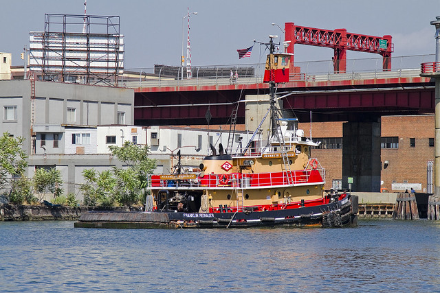
Built in 1984, by Rayco Ship and Main Ironworks of Bourg, Louisiana as the Franklin Reinauer for Reinauer Transportation Companies of Staten Island, New York.
The Franklin Reinauer was the last tug built by the yard, after the construction of three push boats for another company, in 1985 the yard went out of business.
The tug is the second to bear the the name. The first tug that bore the name Franklin Reinauer was renamed as the Matthew Tibbetts.
She is a twin screw tug rated at 2,600 horsepower.

– photo by Mitch Waxman
Pictured in many poses and places in this posting, and presented perspicuously is the tugboat which men call the Franklin Reinauer. Often garish, the “colorway” of each tugboat company is designed to be instantly recognizable at distance. There is something lovely about the Reinauer company’s brand colors of scarlet and orange, which provides primal contrasts with the surrounding azure and cerulean waterscape of New York Harbor.
from fireboat.org
When the Coast Guard called for all assistance, some tugboats were already at the scene with others making ready to assist. The tugboat Franklin Reinauer, under Capt. Ken Peterson and followed by three other Reinauer tugboats, arrived at the Battery seawall around 1130. Peterson said he radioed the MCC aboard the pilot boat New York for permission to go to the Battery seawall to take on passengers. Seeing 10 other tugboats standing off the Battery, he radioed them to come to the seawall. “People started running for the boats and I got off and started directing traffic,” Peterson said. “The first day, we had 27 tugboats on the Battery wall and five at Pier 11.” Tugboats from Moran, McAllister, Turracamo, Reinauer, Penn Maritime, Skaugen PetroTrans, Weeks Marine and other companies responded and continued to arrive during the afternoon. “It quickly became a collaborative effort with Andy McGovern, Ken Peterson and me determining how to best employ all the resources,” Day said.
Fire-fighting efforts at Ground Zero relied heavily on water supplied by two city fireboats and a welcome addition, the ex-New York City fireboat John J. Harvey. Privately purchased by outbidding the scrap dealers in 1999, the boat had been repaired since then and docked at Hudson River Pier 63.
– photo by Mitch Waxman
Luck has placed me at enviable vantages all summer, and an enormous amount of time has been spent on and around the harbor, during which the Franklin Reinauer seemed almost a companion. Everywhere I went, it seemed the tugboat was there too. In the shots above, the Franklin Reinauer was maintaining a static position before the Pulaski Bridge on the Newtown Creek, undoubtedly awaiting the arrival of some stalwart steward of the drawbridge who would open the span and allow it further egress.
from wirednewyork.com
Newtown Creek is woven deeply into the city’s history. Until the Dutch arrived, the Maspetches Indians lived along its banks in what is now Maspeth, Queens. Some believe that Captain Kidd used a friend’s waterfront property there to stash his plunder. The creek was part of a boundary dispute from the mid- 1600’s to the mid-1700’s between Bushwick and Newtown, the precursors to Brooklyn and Queens.
But it was through commerce that the waterway came into its prime.
By the 1850’s, the creek was an industrial center that both fueled and paralleled the explosive growth of New York. Glue factories, smelting and fat-rendering plants, one of the earliest kerosene refinery and other smelly enterprises clustered along the shores of the creek and its little tributaries. The toxic sludge from these businesses got company in 1856, when the city decided to dump raw sewage directly into the water, a practice that continued for decades.
In the 1920’s and 30’s, the creek was widened to accommodate the growing traffic. In its heyday, the bridges that crossed it opened tens of thousands of times a year.
“Newtown Creek was a highway,” said Bernard Ente, a local historian. “It was just boats instead of trucks.” He estimated that 500 enterprises lined the creek at its peak. Large boats brought in raw materials and fuel and took out oil, fat, varnish, chemicals and metals.

– photo by Mitch Waxman
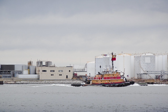
There it is again, this time in the legend choked waters off of Red Hook, and exiting the Erie Basin. A small number of Reinauer tugs and barges are often observed here at Erie Basin, which is known to most New Yorkers for the large Ikea store and NY Water Taxi Ferry service which docks here.
from pbs.org
From the mid-1800s to the mid-1900s, Red Hook’s port made it a thriving industrial neighborhood of mainly Italian and Irish American dockworkers. It was also home to one of the first Puerto Rican neighborhoods in New York City. By 1950, Red Hook had 21,000 residents, many of them longshoremen living in the Red Hook Houses, a public housing project built in 1938 to accommodate the growing number of dockworkers and their families. The neighborhood had a tough reputation—with such notorious figures as Al Capone getting their start there as small-time criminals—and its seedy side was immortalized in movies such as the On the Waterfront (1954), starring a young Marlon Brando.
When containerization shipping replaced traditional bulk shipping in the 1960s, many businesses at the Red Hook ports moved to New Jersey—as did the jobs. Unemployment increased quickly as industries abandoned Red Hook, and the neighborhood’s economy underwent a rapid decline. By the 1970s and ‘80s, it became known as being a crime-ridden, desolate neighborhood, severed from the rest of Brooklyn.

– photo by Mitch Waxman
Mundane and sometimes odd coincidences of geography, maritime, and industrial usage create an unbearable historical similarity between Red Hook and Greenpoint which are deeper and more meaningful than some merely visual verisimilitude. Just on the other side of Erie Basin is the legendary Gowanus canal, Newtown Creek’s superfund.
from brooklyncb6.org
The industrial businesses that exist in Red Hook rely on trucking as the primary way to move goods and freight into and out of the area. Heavy truck traffic has had a serious impact on the residential population and most likely contributed to infrastructure failures and the collapse of some of the older buildings in the area. The geological substrata of this coastal floodplain region contains a dense organic layer of red clay (hence the “red” in Red Hook) that exacerbates the longitudinal transmission of surface vibrations. For years efforts have been underway to reevaluate the existing Truck Route network with an eye toward minimizing its direct impact on the residential community while optimizing its intended industrial usage. The existence of truck-based solid waste transfer stations, that provide little by way of economic development of the community, has contributed to the problem of truck traffic in a major way.

– photo by Mitch Waxman
The Newtown Creek and Gowanus Canal have both been largely abandoned by those industrial forces which ruined their honor, but the tugboat has also and often been sighted in the place where these forces find modern occupation- the storied waterway called the Kill Van Kull.
Here is the Franklin Reinauer straddling this currently undefended border between New York and New Jersey.
from wikipedia
The name “Kill van Kull” has its roots in the early 17th century during the Dutch colonial era, when the region was part of New Netherland. The naming of places by early explorers and settlers during the era often referred to a location in reference to other places, its shape, its topography, and other geographic qualities. The area around the Newark Bay was called Achter Kol. The bay lies behind Bergen Hill, the emerging ridge of the Hudson Palisades which begins on Bergen Neck, the peninsula between it and the Upper New York Bay. Behind or achter the ridge, was a col or passage to the interior. Kill comes from the Middle Dutch word kille, meaning riverbed, water channel, or stream. During the British colonial era the bay was known as Cull bay.
Kill van Kull translates as channel from the pass or ridge. The name of the sister channel to the Kill van Kull, the nearby Arthur Kill, is an anglicization of achter kill meaning back channel, which would refer to its location “behind” Staten Island.
– photo by Mitch Waxman
Preparations for a vast undertaking, as mentioned in the first sentence of this evasive post, have finally been completed- a task which Sisyphus himself would have appreciated. Woe, that today I cannot accomplish my sincerest desire to announce these upcoming events. All a humble narrator can say at this moment would be:
Want to see something cool?
Bring a camera, and ID,
Follow me…
from wikipedia
Seagoing tugboats are in three basic categories:
- The standard seagoing tugboat with model bow that tows its “payload” on a hawser.
- The “notch tug” which can be secured in a notch at the stern of a specially designed barge, effectively making the combination a ship. This configuration is dangerous to use with a barge which is “in ballast” (no cargo) or in a head or following sea. Therefore, the “notch tugs” are usually built with a towing winch. With this configuration, the barge being pushed might approach the size of a small ship, the interaction of the water flow allows a higher speed with a minimal increase in power required or fuel consumption.
- The “integral unit,” “integrated tug and barge,” or “ITB,” comprises specially designed vessels that lock together in such a rigid and strong method as to be certified as such by authorities (classification societies) such as the American Bureau of Shipping, Lloyd’s Register of Shipping, Indian Register of Shipping, Det Norske Veritas or several others.These units stay combined under virtually any sea conditions and the “tugs” usually have poor sea keeping designs for navigation without their “barges” attached. Vessels in this category are legally considered to be ships rather than tugboats and barges must be staffed accordingly. These vessels must show navigation lights compliant with those required of ships rather than those required of tugboats and vessels under tow. Articulated tug and barge units also utilize mechanical means to connect to their barges. ATB’s generally utilize Intercon and Bludworth connection systems. Other available systems include Articouple, Hydraconn and Beacon Jak. ATB’s are generally staffed as a large tugboat, with between seven to nine crew members. The typical American ATB operating on the east coast, per custom, displays navigational lights of a towing vessel pushing ahead, as described in the ’72 COLREGS.
Harbor tugs. Historically tugboats were the first seagoing vessels with steam propulsion, providing freedom from the restraint of the wind. As such, they were employed in harbors to assist ships in docking and departure.
River tugs River tugs are also referred to as towboats or pushboats. Their hull designs would make open ocean operation dangerous. River tugs usually do not have any significant hawser or winch. Their hulls feature a flat front or bow to line up with the rectangular stern of the barge.
June 6th, Magic Lantern Show at Greater Astoria Historical Society

Metropolitan Avenue Bridge, English Kills – photo by Mitch Waxman
I’ve neglected to inform you all of the Magic Lantern Show which this, your Newtown Pentacle, is staging at the Greater Astoria Historical Society on Monday, June 6th at 7pm. There won’t be any archaic museum pieces in use, of course- my magic lantern is all digital and uses a standard and quite modern projector- but the concept is much the same. A photographer captures some hellish reality from the wild and shadowed corners of the world, and presents them with the intention of revealing hidden truths to a comfortable and otherwise wholesome audience who would never encounter this reality otherwise.
from a Newtown Pentacle post of April 13th, 2011
Just under an hour long, this Magic Lantern Show about Newtown Creek is personally narrated, and transports the viewer to every corner of the Newtown Creek- every tributary and street end, on the water and above it, and is presented in the idiosyncratic and off beat manner which has become familiar to regular readers of this- your Newtown Pentacle. It attempts to explain certain core questions in under an hour which have been repeatedly presented to me over the last couple of years, and the entire talk is illustrated with both my own photography and the product of my historical research:
- What exactly do you mean by the “Newtown Pentacle”?
- When did the Newtown Creek begin to matter?
- Why should I care, how does the Newtown Creek affect me, as I live in Manhattan?
- Where exactly is this place?
- Who is responsible for this mess, and exactly who is it that’s going to clean it up?
- How can I get involved and help my community revitalize and or restore the Newtown Creek?

Empire State Building rising over industrial Brooklyn and Newtown Creek – photo by Mitch Waxman
It would probably be “politique” to mention that this is not a Newtown Creek Alliance event, which is one of the many organizations which I’ve become affiliated and identified with. Instead this is purely a Newtown Pentacle show, which the studied philosophs who inhabit the upper echelons of the Greater Astoria Historical Society are allowing me to present in their convenient location on Astoria’s Broadway- stumbling distance from the R,M, and N trains. The efficacy of gambling their precious time and effort upon such a poor specimen as myself would be proven by the event being well attended, and the negligible $5 fee at the door should prove an easy burden for most to bear. Therefore, a narrator humbly invites and requests your support and attendance.
from astorialic.org
Mon Jun 6, 7:00 pm
Travel the length and breadth of Americas most polluted waterway, the Newtown Creek, with newtownpentacle.com‘s Mitch Waxman.
Breathtaking photography illustrates the journey, exploring the various tributaries and discussing the industrial history of New York City‘s least known waterway.
Witty and irreverent, the narration describes Waxman‘s own discovery of this place and the fantastic journey it has taken him on.
Question and Answer period follows.

DUKBO, Down Under the Kosciuszko Bridge Onramp – photo by Mitch Waxman
The actual presentation is just over a hour long, and during it, you’ll travel the length and breadth of the Newtown Creek- every tributary and bridge, each keystone of historical import will be illustrated with both personal experience and historical meaning. For those of you new to the story of the Newtown Creek (or the neighborhood) this will make a fine primer. Attempts will be made by your humble narrator to reveal this willfully hidden place, and introduce the uninitiated to the hellish flames of revelation which only the Newtown Creek can offer.

Greenpoint Avenue Bridge over Newtown Creek – photo by Mitch Waxman
The places I go, the things I see… often strain credulity. This is not the world you know, this 3.8 mile long waterway located directly across the East River from Manhattan’s Bellevue Psychiatric Hospital which provides the currently undefended border of Brooklyn and Queens. If it can happen, it has happened here, and if it happened here it happened worse and grander than anywhere else it ever happened. Come visit the night soil and offal dock, hear the stories of the great men- Bliss and Kingsland and Flowers and Degnon and Cooper. This is the place where the Industrial Revolution actually happened, where the death of nature itself was accomplished, and our modern world was born.
Welcome to the Newtown Creek, poison heart of the Newtown Pentacle…
longings and welcome

– photo by Mitch Waxman
The first bit of business today is about our departed friend Bernie Ente, and a memorial moment we have planned for the Newtown Creek Cruise tomorrow.
As many of you know, Bernie was and remains an inspiration to those of us involved in the story of Newtown Creek, in many ways he was “the King of the Creek”. He was the founder and institutor of this annual exploration of the troubled waterway, and there won’t be anyone connected with the organization and execution of this trip who won’t acutely feel his absence.
Accordingly, there is going to be a memorial moment performed for our fallen King, and several people have contacted me saying they wish to be present, but cannot afford the price of the boat trip. I have been instructing all who wish to attend to gather at the Maspeth Avenue street end (click here for google maps location and pictured above) and be there by 11:30. You’ll see a gigantic boat coming up the Creek, that’ll be us. The whole shebang will be short and sweet, as Bernie would be embarrassed by such honorifics and would chide me to focus in on what’s truly important- the revelation of Newtown Creek’s often occluded past, and the stunning possibilities for our communities offered by it’s revitalization and renewal.
Erik Baard will be paddling up the Creek with Richard Melnick of the Greater Astoria Historic Society, should any of you wish to attend on the water, although I stress that this is not an official Long Island City Boathouse event. Erik can be contacted via this facebook link if you wish to join them.
(afterwards, you can then cross the Grand Avenue Bridge and head over to Rust Street, where a rally to save the St. Saviour’s site and turn it into a City Park is meant to be happening at 1pm, but you’ll have to hit Google for specifics on that- I’ve been too busy with my own business to pay much attention to this effort in the last month- but there’s meant to be quite a gathering of elected officials and the folks from COMET and other Maspeth based community groups)

– photo by Mitch Waxman
Secondly, when our vessel returns to South Street Seaport at 1pm, those of you onboard who wish to discuss what you’ve just seen with Working Harbor personnel and or your humble narrator should plan on joining us for our customary post game. We will be proceeding to a local cafe bar where the camaraderie and libation will flow, and a relaxed conversation will be offered. Your tab, of course, is your own. This is not a part of the tour, and is not offered as part of the ticket price, but if you buy old Mitch a drink or two- he might tell you about some of the unknowable things he’s seen dancing around in the Creek during thunderstorms or share the story of the “Blissville Banshee” with you.
Nothing loosens Mitch’s tongue like a flask of cheap hip pocket liquor.

– photo by Mitch Waxman
Lastly, and I promise- this is the last time you’ll see this string of text, there are still a few ticketed seats available but I can’t promise they’ll be there when you leave work tonight. If you’ve been prevaricating about whether or not to come, now is the time to “drop the hammer”.
And… did I mention we’ve got a speaker from Riverkeeper scheduled to be onboard?
Lastly:
It is critical for you to purchase tickets for the Newtown Creek Cruise soon. We’re filling up rapidly and seating is limited. Your humble narrator is acting as chairman for this journey, and spectacular guest speakers are enlisted to be onboard. Click here to order tickets. Something I can promise you, given the heavy rain we’re having at the beginning of this week, is that the Newtown Creek will be especially photogenic on Saturday. Current forecasts call for “Partly sunny. A slight chance of showers in the morning. Highs in the mid 70s. North winds around 5 mph. Chance of rain 20 percent” (we leave the dock at 10- late morning)! Photographers in Greenpoint, Long Island City, and beyond- this is going to be hyperfocal MAGIC.
From workingharbor.com
he May 21st, Newtown Creek Cruise:
Explore Newtown Creek by Boat
Saturday, 21 May, 2011
Pier 17, South Street Seaport.
Departs 10 am sharp
Returns 1 pm
Price: $60
Join us for a special water tour with expert narration from historical and environmental guest speakers.
There are limited tickets available on the MV American Princess for a very rare tour of Newtown Creek. Guest narrators will cover points of industrial and historical interest as well as environmental and conservation issues during your three-hour exploration. New York’s forgotten history will be revealed – as well as bright plans for the creeks future.
MV American Princess is a large, comfortable vessel with indoor and outdoor seating. Complimentary soft drinks and a tour brochure are included.
Cruise runs rain or shine
Queries? Contact Tour Chairman Mitch Waxman: waxmanstudio@gmail.com
Hosted by Hidden Harbor Tours ® in association with the Newtown Creek Alliance.


