Posts Tagged ‘English Kills’
formula filled
My creek also puts on a show when I’ve been away from her too long.
– photo by Mitch Waxman
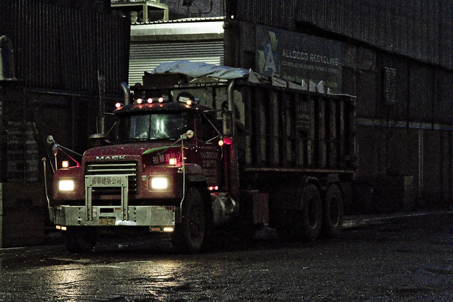
One of my practices, developed over the last decade or so, is to take a Newtown Creek break periodically and “allow my liver to return to a normal size.” I’m joking about the liver, but one does enjoy a bit of detox occasionally, and allowing the poisons I’ve accrued a chance to leach out. This is a luxury one enjoys, as he doesn’t live along Newtown Creek, others aren’t so lucky. Pictured above is roll on/ roll off garbage truck carrying a bin, spotted at a waste transfer station owned by a friend of mine which fairly straddles the border of Brooklyn and Queens.
– photo by Mitch Waxman
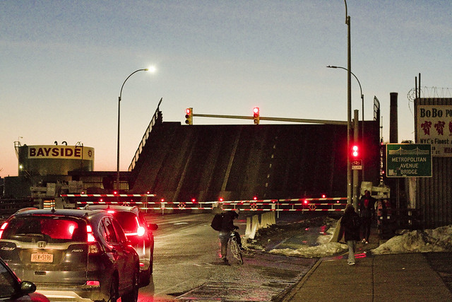
Marching along Metropolitan Avenue, one squealed with delight as the Metropolitan Avenue Bridge began to open. This used to be quite a frequent occurrence “back in the day.” These days there’s only one regular maritime customer back here on the English Kills tributary, which is Bayside Fuel.

– photo by Mitch Waxman
The timing of the bridge opening was bizarre, occurring at precisely the time of one of the heaviest traffic intervals in this section of North Brooklyn, about 6:30 p.m.

– photo by Mitch Waxman
That odd timing, however, allowed one to stand in the middle of Metropolitan Avenue without getting squished.

– photo by Mitch Waxman
I believe that the tug pictured above is the Mary H., which normally handles the Bayside duty, but it’s hard to say as I didn’t get any of its markings. I did manage to focus in on the captain in his wheelhouse, however, so “win.”
As a note, the Metropolitan Avenue Bridge spans the English Kills tributary of the larger Newtown Creek at a navigational mark 3.4 miles eastwards of the East River. Metropolitan Avenue was originally created as a private toll road about 1814, and was called the Williamsburgh and Jamaica Turnpike. The owners of the toll road, and the original bridge, were two brothers whose family name was Masters. That’s why you’ll occasionally see references to the road as the “Masters Turnpike” and the “Masters Bridge” in the historical record, if like me, you stay up until 4 in the morning reading old municipal journals and reports from the Chambers of Commerce of Brooklyn or Queens.

– photo by Mitch Waxman
My conceit is to call this area of Newtown Creek surrounding the Metropolitan Avenue Bridge “DUMABO.” That’s short for “Down Under the Metropolitan Avenue Bridge,” as I believe we need to be ahead of the real estate people on these sorts of things.
“follow” me on Twitter- @newtownpentacle
ignorantly spared
Back on the job.

– photo by Mitch Waxman
Since the recent extreme cold spell has broken, a humble narrator has found himself marching about again, and boy are my dogs barking. On Tuesday, a stroll over to Bushwick East Williamsburg was enacted and the farthest reaches of the Newtown Creek at English Kills were observed. As expected, the waterway was frozen over.

– photo by Mitch Waxman
Toxic ice. You don’t get to say that particular phrase that too often, but that’s what you’re looking at in the shot above. English Kills is the far eastern terminus of Newtown Creek, which branches off of the East River nearly 3.8 miles from the larger waterbody. These shots were gathered at about 3.7 miles back.

– photo by Mitch Waxman
That big sewer outfall at the end of the tributary is the 3.8 mile terminus mark, and the north/south street seen beyond the fencelines is Johnson Avenue. The surrounding neighborhood is gentrifying (dictionary definition of gentrifying), but on a fairly small scale as compared to points found to the west like LIC and Greenpoint.

– photo by Mitch Waxman
One decided to hang around the neighborhood for a bit and stretch my legs after the long interval of being trapped in the house by inclement clime, and visit a few of my favorite places. This shot is from the Scott Avenue footbridge, which spans the LIRR’s Bushwick Branch freight tracks, just as the burning thermonuclear eye of God itself was dipping behind New Jersey to the west.

– photo by Mitch Waxman
Heading over towards Metropolitan Avenue, and another of the dead end tributaries of Newtown Creek – the East Branch, one discovered that this section of the water was similarly locked in a decidedly polar state.

– photo by Mitch Waxman
The ice was decaying faster in both waterways where it touched the open sewer outfalls, no doubt due to the flow of melt water laden with road salt coming in from as far away as Canarsie. This untreated sewage is quite biologically active as well, and the metabolism of the microscopic entities contained in the water column likely helps to warm it up a bit.
“follow” me on Twitter- @newtownpentacle
quiet removal
It’s National Boston Creme Pie Day, in these United States.

– photo by Mitch Waxman
If you want to know what the end of the world looks like, I can take you there. It’s about 3.8 miles from the East River, in an area of Brooklyn that is clearly Bushwick but which the real estate people refer to as East Williamburg. The end of the world is surrounded by heavy industry and waste transfer stations, and is crossed by a railroad bridge. It’s defined by a waterbody called English Kills, which is a dead end tributary of the fabulous Newtown Creek.
Just last week, a visit was paid to this paradise of nihilism.

– photo by Mitch Waxman
The open sewers are just one of the apocalyptic factors back here, as is the enormous waste transfer station operated by a transnational conglomerate that handles about a third of the black bag (or putrescent) garbage collected by the Department of Sanitation. There is virtually zero laminar flow to the water here, which means that the rising and falling of the tide is a vertical affair rather than a horizontal one, creating stinking shoals along the banks and allowing sediment mounds to rise from the channel. It often smells like rubber cement thinner along this stretch of English Kills, the waters are greasy, and they commonly exhibit an uncommon and unnatural coloration highlighted by patches of weird iridescence.
Men and women seem to become possessed by the spirit of the place, wildly dumping garbage into the shallows with a gleeful abandon.

– photo by Mitch Waxman
References in the historical record refer to distinct periods in English Kills’ existential course. Once, a mostly fresh water stream fed by the springs and streams of a Bushwick that drew German beer Brewers to the area, which bled sweet water into the main body of Newtown Creek, just a decade after the American Civil War English Kills began to be described as the “industrial canals of Brooklyn.” By the time that the Army Corps of Engineers oversaw the WW1 era shaping of the Newtown Creek watershed into something we would recognize on a google map in modernity, English Kills had open pipes carrying industrial and chemical waste products into the water from acid factories and the other dirty industries surrounding it. The upland springs and steams which drew the brewers here were paved over or turned into sewers, and the only naturally occurring liquid entering the narrow channel afterwards was a tepid trickle of brackish East River water (which was itself terribly compromised) weakly pulsing in with the daily tide, or storm runoff from the streets.
Brooklyn legend suggests this area was used as a graveyard by mobsters, but that’s just a legend. Gangsters dump bodies into fast moving or oceanic water bodies like Jamaica Bay or the Hudson River. The idea is to get rid of the evidence, not to leave something incriminating in a place where it can be found.
Whatever enters English Kills stays in English Kills.

– photo by Mitch Waxman
The structure pictured above is the Montrose Avenue Railroad Bridge, part of the Bushwick Branch lead tracks of the Long Island Ralroad. The bridge, and adjacent fencelines, are covered in odd graffiti which is in English but drawn with characters that betray a runic influence. The screeds warn of witches and other mythological creatures.
This is what the end of the world looks like, if… like me… the borders of your world are defined and bisected by that lugubrious ribbon of urban neglect known as the Newtown Creek.
Upcoming Tours and events
Exploring Long Island City, from Luxury Waterfront to Abandoned Factories Walking Tour,
with NY Adventure Club – Sunday, November 12th, 2:30 p.m. – 4:30 p.m.
Long Island City is a tale of two cities; one filled with glittering water-front skyscrapers and manicured parks, and the other, a highly active ground transportation & distribution zone vital to the New York economy — which will prevail? With Newtown Creek Alliance Historian Mitch Waxman – details here.
“follow” me on Twitter- @newtownpentacle
hidden laboratory
It’s International Cheese Day, for the industrialized and lactose tolerant nations of this planet.

– photo by Mitch Waxman
3.4 miles from the East River is a spot which one refers to as DUMABO – or Down Under the Metropolitan Avenue Bridge Onramp. The first bridge over the flowing waters of English Kills was erected here (slightly to the west, actually) in 1814 and was privately owned by the Masters brothers, so it was accordingly referred to as the “Masters Bridge.” Historic sources indicate this spot as being, during the colonial to civil war period, the demarcation point between salt and fresh water on the English Kills tributary of the fabulous Newtown Creek. Shellfish were described as being found in “great abundance.” It was once known as White’s Dock, for the vulgarly curious. The precursor of the modern day Metropolitan Avenue Bridge was built in the 1870’s, and the modern bridge (much altered) was erected in 1931.
The fresh water was being fed into English Kills by upland springs and streams in nearby Bushwick that flowed downhill into it, and by ground water entering it from the bottom. Back in 1814, Metropolitan Avenue was just a wooden plank toll road rising up from the swamps, and it was called the “Williamsburgh and Jamaica Turnpike road.” The springs and streams of Bushwick are what attracted beer breweries like the Ulmer people to a then German speaking rural neighborhood to ply their trade, but I digress. The fat renderers and acid factories began to show up in the 1830’s and 40’s around these parts, and notably – Peter Cooper’s “pestilential” glue factory, where Jello was invented, was just a few blocks away.

– photo by Mitch Waxman
NYC DOT has been doing a bunch of work at this spot recently, some sort of construction that they attached to the bridge itself. Unfortunately, they didn’t do anything about the loose soil on the shoreline, nor the decaying wooden bulkheads holding that shoreline in place. Of course, not many people come back here, but it would have been fairly easy to fall into English Kills given the rotting shoreline when the shot above was captured.

– photo by Mitch Waxman
That’s the Mary H. tug, tied up to the Bayside Fuel Depot bulkheads, just east of the Metropolitan Avenue Bridge. This is pretty much the extent of serious maritime access to English Kills given the black mayonnaise/sediment mound situation that gobbles up operational draught and depth. The green wall with all the kit on top is Waste Management’s Varick Street Waste Transfer Station. The Waste Management facility handles predominantly “putrescent” or black bag garbage for the NYC Department of Sanitation, which is processed on site and then loaded onto the so called “garbage train” which travels on the tracks of LIRR’s Bushwick Branch to Fresh Pond and then over the Hell Gate Bridge to points unknown.
Seriously, unknown. I’ve asked and was told “homeland security” precluded the dissemination of where NYC’s garbage is dumped.

– photo by Mitch Waxman
One headed up Varick Street towards industrial Bushwick from Metropolitan Avenue, where this spectacular salt dome structure was encountered. Seriously, no sarcasm is offered, this was a visually interesting and somewhat elegant solution to the problem. The rest of the neighborhood is dull, weathered, depressing. It’s nice to see a bit of color and style on display for something so pedestrian. It’s right next door to the Waste Management facility on Varick Avenue.

– photo by Mitch Waxman
The streets in this section, just south and east of Newtown Creek, are industrial in the extreme. Heavy trucking, the garbage industrial complex… suffice to say that the roadways aren’t exactly bike or pedestrian friendly, and that they are in a sorry state of repair. Watch your step hereabouts, and never cross in front of a driveway without first taking a look. This part of the Newtown Creek watershed is what the band Metallica was likely describing with their “death magnetic” album. There’s “ghost bikes” everywhere you look, the air is a poisonous fume…
Yep, it’s pretty much Tolkien’s Mordor back here.

– photo by Mitch Waxman
Turning off of Varick, I found myself wandering down Stewart Avenue and onto Randolph Street towards the undefended border of Brooklyn and Queens and that hazy industrial borderland which can either be called Ridgewood, East Williamsburg, or Bushwick – depending on whom you ask. Saying that, move quickly through this area, don’t talk to anyone, and certainly do not ask them questions if they speak to you. I would expand on why, but I’d again be told that I’ve seen too many movies, by some rich guy that moved to Hipster Bushwick from Connecticut less than six months ago who is trying to connect with a local art or club scene that they heard about on Instagram.
Of course, I couldn’t have more inconspicuous – the only person for about a square mile not wearing a safety vest and hard hat, and instead clad in a filthy black raincoat flapping about in the poison wind while waving a camera about.

– photo by Mitch Waxman
Speaking of the Bushwick Branch of the LIRR, which carries the garbage train from Bushwick into Queens and its mysterious destination on the continent, it’s just beyond that fence in the shot above. It’s been a while since I wandered through here, and those corrugated fences you see are fairly new, as evinced by a near total lack of graffiti. Back to the implied presence of criminally inclined individuals who are organized into a structure which one might define as a “crew” or a “family,” I’d point out the total lack of graffiti on a visible fence line in North Brooklyn – the high end graffiti capital of these United States.
Go ask someone who grew up in Brooklyn or Queens what that means.
Nevertheless, as is always the case when wandering through the industrial zones surrounding the fabled Newtown Creek, that horrible inhuman thing with the three loved burning eye that cannot possibly exist in the sapphire megalith of Long Island City was watching. It sees all, owns all, knows all.
More to come, next week, at this – your Newtown Pentacle.
“follow” me on Twitter- @newtownpentacle
greatest suddenness
Vas doin on English Kills, boychik, mit the bubbles?

– photo by Mitch Waxman
DUMABO. Down Under the Metropolitan Bridge Onramp, is a spot that bisects the pathway of the so called “industrial Canals of Brooklyn” or English Kills. The darkest thicket of the troubled Newtown Creek, English Kills is largely isolated from casual perusal by the electorate by a continuous shield wall of industrial buildings, which means that what happens on the water is usually commented on by an unlucky few such as myself. The engineered path that the water flows through follows the Brooklyn street grid, which creates a series of right angle turns that impede the tidal actions of the East River which is some 3 miles from here.
This adherence to the street grid, and the hydrological issues it introduces, has caused huge accretions of the so called “Black Mayonnaise” sediments to agglutinate. This sedimentation, along with the summer heat, causes the water to be “anoxic,” meaning that it often carries little or no dissolved oxygen. This kills off any aquatic life that may have wandered back here, and promulgates the colonies of sewage bacteria in the water whose aromatic exhalations remind one of rotting chicken eggs.
The sewage bacteria is provided by the many CSO’s (Combined Sewer Outfalls) found along the waterway.

– photo by Mitch Waxman
To combat these anoxic conditions, the ever reliable NYC DEP (in concert with the state DEC) have installed an aeration system. Basically a giant pipe through which pressurized air is pumped, the thing operates in the same manner as a bubble wand on your aquarium fish tank. Disturbing the surface allows atmospheric gases like oxygen to become dissolved in the water. The DEP building you’ll notice on Metropolitan Avenue in East Williamsburg that adjoins the Metropolitan Avenue Bridge contains the air compressors.
It all sounds rather logical, as the efforts of engineers often do. Problem is that the sewage bacteria conditions are being caused by the Combined Sewer Outfalls on English Kills, which the DEP engineers are not focusing on. It’s sort of like shitting in a fish tank every day, and attaching more and more aerating bubble wands to combat the conditions being caused, without doing anything about… y’know, not shitting in your aquarium.

– photo by Mitch Waxman
Here’s the problem – my pals over at Riverkeeper have voiced MAJOR concerns about this system, and cite a study by M. Elias Dueker which shows that bacterial fauna from English Kills are provided with an opportunity to enter the air via this system. A “Culturable Bacterial Aerosol” as they describe it, is allowed purchase into the atmosphere.
Said organisms can then find a home on any friendly terrestrial surface.
In effect, these bubbles provide a ladder for the worst pathogens in the Newtown creek watershed an opportunity to get up and out of the water. Keeping this sort of bacteria away from the general populace is sort of the mission of the DEP, btw.
from riverkeeper.org
Riverkeeper raised concerns when the city proposed aerating the rest of the creek last spring and asked the DEP to test for pathogens and sewage associated bacteria in the air, which they did not agree to do. Aeration creates bubbles on the water’s surface and is a Band Aid solution to the underlying serious problem of combined sewage overflows. Low oxygen conditions in the creek occur due to sewage contamination and although aeration increases the oxygen level in the water, it does not reduce the amount of sewage or sewage associated bacteria that are dumped into the creek. Riverkeeper has argued that aeration is an ineffective way of addressing the pollution problem and the recent study suggests that it may also negatively impact local air-quality.

– photo by Mitch Waxman
Worse still, the aeration system performs its job quite well. Dissolved oxygen levels in English Kills are higher than they used to be. Accordingly, the DEP is planning on expanding the system from English Kills all the way to the Greenpoint Avenue Bridge, more than a mile away.
The pipes are planned to follow the contour of the Queens coastline, of course, because you wouldn’t be able to get away with doing it on the Brooklyn side. This puts Maspeth, and parts of Sunnyside and Blissville, in the path of the pestilent wind which would rise from the loathsome Newtown Creek.
“follow” me on Twitter- @newtownpentacle


