Archive for the ‘Brooklyn’ Category
usual symptoms

– photo by Mitch Waxman
Existential reality and physical weakness govern this day, as your humble narrator is off to the shining city for consultations with the staff of medical specialists and practitioners whose art maintains an acceptable equilibrium between life and death for him. They plan on siphoning off some of my very lifeblood, and subjecting it to alchemical tests, as well as poking and piercing at my increasingly fragile leather with instrumentation whose appearance fills me with a nameless dread. Their prescribed potions will be assessed for effectiveness, and I will face inquisition regarding diet and lifestyle.

– photo by Mitch Waxman
Such exposure to the vagaries of science are required by the increasing fragility and easily upset homogeneity of life as one grows older, part of the overdue bill owed to the universe for that lifestyle of youthful vulgarity and distasteful indulgence which I once enjoyed. I prefer to tuck my conscious mind away in a little corner of my head, behind my left ear, and let them do to my body what they will- for that is the whole of their law. The great equalizer in our society is always found in the hospital ward, where commoner and king alike find themselves sitting on a paper covered table while wearing a cheap gown as strangers perform laboratory tests upon them.

– photo by Mitch Waxman
The staff of medical professionals which are employed on my behalf are, despite my lowly status and financial devastation, actually quite competent and highly placed- ignoring their vast experience and advice would be (and is) foolish. Weak in mind as well as body, I often dismiss this advice, but that is is part of the strange trade off one often makes in modern life- sacrificing what you know is good for you in favor of the quick fix and a feel good option. Seldom do I leave their offices without dire predictions or warnings having been offered, and today will most likely not be an exception.
nighted secrets

– photo by Mitch Waxman
This has been one crazily busy few days for your humble narrator, and frankly- I’m a nervous wreck.
Tonight, the Metropolitan Waterfront Alliance will be hosting the “Heroes of the Harbor” soiree at Pier 61 on the Hudson River at 6 p.m.- that’s Chelsea Piers for those unfamiliar with the demarcation of Manhattan’s surviving docks.
The MWA will be presenting the “Parade of Boats” at sunset, which will include (amongst others) the FDNY’s bon vivant “Three Forty Three” Fireboat. I’ll be there attempting to photograph the show.
Additionally, I remind you of the announcement made late Friday afternoon about the Working Harbor Committee and Newtown Creek Alliance produced boat tours of Newtown Creek on October 23rd which I will also be participating in. Tickets sales are flying, so order yours today.
“Join me on two Newtown Creek boat tours, both on October 23rd, 2011. I’ll be your tour guide, narrating humbly.
These tours are the co production of the Working Harbor Committee and the Newtown Creek Alliance made possible by funding from the NYCEF Newtown Creek Fund of the Hudson River Foundation. Accordingly, the tours will be heavily discounted, and tickets will cost only $10.
Made possible by funding from the NYCEF Newtown Creek Fund of the Hudson River Foundation”

– photo by Mitch Waxman
Inadvertently, your humble narrator caused some confusion with that aforementioned post from Friday afternoon when a draft version was published which listed the wrong date and time for the two tours, and apologies are offered. Thanks are offered to the many sharp eyed readers of this, your Newtown Pentacle, who immediately let me know that an error had been published.
I long for the days of winter at this point, when solitary communion with my beloved Creeklands can be embraced again.
Oh, to fly with the night gaunts over the concrete desolations and haunt the rolling hillocks of Newtown once more …
So speaks the contemplative mood experienced by your humble narrator today…

– photo by Mitch Waxman
For those of you new to my little world- here’s how this whole thing got started:
Several years ago, after a serious illness brought on by a slothful and overly indulgent lifestyle, my staff of doctors had prescribed exercise and wholesome activity as a curative. They told me to run, but having grown up in Brooklyn- I only run when someone of something is chasing me- so I began to walk. A shabby and defeated man in a filthy black raincoat, camera in hand, reduced to walking the earth in the manner of a mendicant. Vastly inferior to others, and perhaps the worst of men, I am an unpleasant fellow given to tidal fluctuations of mood and temperament which cause me to display an uncompromising face to all. Accordingly, the world had crumpled me up and thrown me away like so much refuse. I put away childish things, and disappeared into the wastelands of western Queens.
Like every other discarded piece of wind strewn trash casually thrown away in the city of New York, I eventually turned up at the Newtown Creek. The emerald devastations of Calvary, the mysteries of a forgotten world of industrial supremacy, the wonders of a deeply hidden world had been awaiting me. The hellish green flame of revelation soon presented itself here, at the Creek, and before I knew it- my various researches, photographs, and activities were noticed by both the historical community and political establishment of Queens.
Before long, I found myself standing alongside respected scholars and scientific pillars, advocating for the Creek in public, and telling its story to boat loads of eager enthusiasts. This is something which I am still getting used to.
A few aphorisms and truisms have emerged in the preceding years- “make no assumptions”, “it’s not good, it’s not bad, it just is”, “next time I go down English Kills in a rowboat, I’m wearing a respirator”, and “if it can happen, it happened here, and if it happened here it was ten times worse than anywhere else”. When the Open House NY walks on the 15th and 16th are done, and the boat tours are finished in October, my plan is to resume solitary wanderings and delve into deeper waters at the Creek which the general public need not visit. As always, I’ll be sharing my pedantic adventures with you, my lords and ladies of the Pentacle.
desolate eternities

– photo by Mitch Waxman
Your humble narrator has been enlaced in several ventures which have required assiduous effort for the last several days. Promissory obligation and contractual agreement precludes revelation of the substance of these recent labors, but suffice to say that sartorial glee will abound about the Pentacle when announcements are uttered aloud.
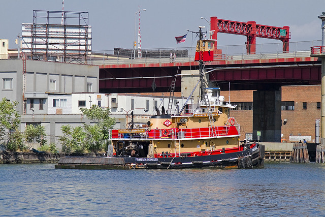
Built in 1984, by Rayco Ship and Main Ironworks of Bourg, Louisiana as the Franklin Reinauer for Reinauer Transportation Companies of Staten Island, New York.
The Franklin Reinauer was the last tug built by the yard, after the construction of three push boats for another company, in 1985 the yard went out of business.
The tug is the second to bear the the name. The first tug that bore the name Franklin Reinauer was renamed as the Matthew Tibbetts.
She is a twin screw tug rated at 2,600 horsepower.

– photo by Mitch Waxman
Pictured in many poses and places in this posting, and presented perspicuously is the tugboat which men call the Franklin Reinauer. Often garish, the “colorway” of each tugboat company is designed to be instantly recognizable at distance. There is something lovely about the Reinauer company’s brand colors of scarlet and orange, which provides primal contrasts with the surrounding azure and cerulean waterscape of New York Harbor.
from fireboat.org
When the Coast Guard called for all assistance, some tugboats were already at the scene with others making ready to assist. The tugboat Franklin Reinauer, under Capt. Ken Peterson and followed by three other Reinauer tugboats, arrived at the Battery seawall around 1130. Peterson said he radioed the MCC aboard the pilot boat New York for permission to go to the Battery seawall to take on passengers. Seeing 10 other tugboats standing off the Battery, he radioed them to come to the seawall. “People started running for the boats and I got off and started directing traffic,” Peterson said. “The first day, we had 27 tugboats on the Battery wall and five at Pier 11.” Tugboats from Moran, McAllister, Turracamo, Reinauer, Penn Maritime, Skaugen PetroTrans, Weeks Marine and other companies responded and continued to arrive during the afternoon. “It quickly became a collaborative effort with Andy McGovern, Ken Peterson and me determining how to best employ all the resources,” Day said.
Fire-fighting efforts at Ground Zero relied heavily on water supplied by two city fireboats and a welcome addition, the ex-New York City fireboat John J. Harvey. Privately purchased by outbidding the scrap dealers in 1999, the boat had been repaired since then and docked at Hudson River Pier 63.
– photo by Mitch Waxman
Luck has placed me at enviable vantages all summer, and an enormous amount of time has been spent on and around the harbor, during which the Franklin Reinauer seemed almost a companion. Everywhere I went, it seemed the tugboat was there too. In the shots above, the Franklin Reinauer was maintaining a static position before the Pulaski Bridge on the Newtown Creek, undoubtedly awaiting the arrival of some stalwart steward of the drawbridge who would open the span and allow it further egress.
from wirednewyork.com
Newtown Creek is woven deeply into the city’s history. Until the Dutch arrived, the Maspetches Indians lived along its banks in what is now Maspeth, Queens. Some believe that Captain Kidd used a friend’s waterfront property there to stash his plunder. The creek was part of a boundary dispute from the mid- 1600’s to the mid-1700’s between Bushwick and Newtown, the precursors to Brooklyn and Queens.
But it was through commerce that the waterway came into its prime.
By the 1850’s, the creek was an industrial center that both fueled and paralleled the explosive growth of New York. Glue factories, smelting and fat-rendering plants, one of the earliest kerosene refinery and other smelly enterprises clustered along the shores of the creek and its little tributaries. The toxic sludge from these businesses got company in 1856, when the city decided to dump raw sewage directly into the water, a practice that continued for decades.
In the 1920’s and 30’s, the creek was widened to accommodate the growing traffic. In its heyday, the bridges that crossed it opened tens of thousands of times a year.
“Newtown Creek was a highway,” said Bernard Ente, a local historian. “It was just boats instead of trucks.” He estimated that 500 enterprises lined the creek at its peak. Large boats brought in raw materials and fuel and took out oil, fat, varnish, chemicals and metals.

– photo by Mitch Waxman
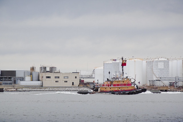
There it is again, this time in the legend choked waters off of Red Hook, and exiting the Erie Basin. A small number of Reinauer tugs and barges are often observed here at Erie Basin, which is known to most New Yorkers for the large Ikea store and NY Water Taxi Ferry service which docks here.
from pbs.org
From the mid-1800s to the mid-1900s, Red Hook’s port made it a thriving industrial neighborhood of mainly Italian and Irish American dockworkers. It was also home to one of the first Puerto Rican neighborhoods in New York City. By 1950, Red Hook had 21,000 residents, many of them longshoremen living in the Red Hook Houses, a public housing project built in 1938 to accommodate the growing number of dockworkers and their families. The neighborhood had a tough reputation—with such notorious figures as Al Capone getting their start there as small-time criminals—and its seedy side was immortalized in movies such as the On the Waterfront (1954), starring a young Marlon Brando.
When containerization shipping replaced traditional bulk shipping in the 1960s, many businesses at the Red Hook ports moved to New Jersey—as did the jobs. Unemployment increased quickly as industries abandoned Red Hook, and the neighborhood’s economy underwent a rapid decline. By the 1970s and ‘80s, it became known as being a crime-ridden, desolate neighborhood, severed from the rest of Brooklyn.

– photo by Mitch Waxman
Mundane and sometimes odd coincidences of geography, maritime, and industrial usage create an unbearable historical similarity between Red Hook and Greenpoint which are deeper and more meaningful than some merely visual verisimilitude. Just on the other side of Erie Basin is the legendary Gowanus canal, Newtown Creek’s superfund.
from brooklyncb6.org
The industrial businesses that exist in Red Hook rely on trucking as the primary way to move goods and freight into and out of the area. Heavy truck traffic has had a serious impact on the residential population and most likely contributed to infrastructure failures and the collapse of some of the older buildings in the area. The geological substrata of this coastal floodplain region contains a dense organic layer of red clay (hence the “red” in Red Hook) that exacerbates the longitudinal transmission of surface vibrations. For years efforts have been underway to reevaluate the existing Truck Route network with an eye toward minimizing its direct impact on the residential community while optimizing its intended industrial usage. The existence of truck-based solid waste transfer stations, that provide little by way of economic development of the community, has contributed to the problem of truck traffic in a major way.

– photo by Mitch Waxman
The Newtown Creek and Gowanus Canal have both been largely abandoned by those industrial forces which ruined their honor, but the tugboat has also and often been sighted in the place where these forces find modern occupation- the storied waterway called the Kill Van Kull.
Here is the Franklin Reinauer straddling this currently undefended border between New York and New Jersey.
from wikipedia
The name “Kill van Kull” has its roots in the early 17th century during the Dutch colonial era, when the region was part of New Netherland. The naming of places by early explorers and settlers during the era often referred to a location in reference to other places, its shape, its topography, and other geographic qualities. The area around the Newark Bay was called Achter Kol. The bay lies behind Bergen Hill, the emerging ridge of the Hudson Palisades which begins on Bergen Neck, the peninsula between it and the Upper New York Bay. Behind or achter the ridge, was a col or passage to the interior. Kill comes from the Middle Dutch word kille, meaning riverbed, water channel, or stream. During the British colonial era the bay was known as Cull bay.
Kill van Kull translates as channel from the pass or ridge. The name of the sister channel to the Kill van Kull, the nearby Arthur Kill, is an anglicization of achter kill meaning back channel, which would refer to its location “behind” Staten Island.
– photo by Mitch Waxman
Preparations for a vast undertaking, as mentioned in the first sentence of this evasive post, have finally been completed- a task which Sisyphus himself would have appreciated. Woe, that today I cannot accomplish my sincerest desire to announce these upcoming events. All a humble narrator can say at this moment would be:
Want to see something cool?
Bring a camera, and ID,
Follow me…
from wikipedia
Seagoing tugboats are in three basic categories:
- The standard seagoing tugboat with model bow that tows its “payload” on a hawser.
- The “notch tug” which can be secured in a notch at the stern of a specially designed barge, effectively making the combination a ship. This configuration is dangerous to use with a barge which is “in ballast” (no cargo) or in a head or following sea. Therefore, the “notch tugs” are usually built with a towing winch. With this configuration, the barge being pushed might approach the size of a small ship, the interaction of the water flow allows a higher speed with a minimal increase in power required or fuel consumption.
- The “integral unit,” “integrated tug and barge,” or “ITB,” comprises specially designed vessels that lock together in such a rigid and strong method as to be certified as such by authorities (classification societies) such as the American Bureau of Shipping, Lloyd’s Register of Shipping, Indian Register of Shipping, Det Norske Veritas or several others.These units stay combined under virtually any sea conditions and the “tugs” usually have poor sea keeping designs for navigation without their “barges” attached. Vessels in this category are legally considered to be ships rather than tugboats and barges must be staffed accordingly. These vessels must show navigation lights compliant with those required of ships rather than those required of tugboats and vessels under tow. Articulated tug and barge units also utilize mechanical means to connect to their barges. ATB’s generally utilize Intercon and Bludworth connection systems. Other available systems include Articouple, Hydraconn and Beacon Jak. ATB’s are generally staffed as a large tugboat, with between seven to nine crew members. The typical American ATB operating on the east coast, per custom, displays navigational lights of a towing vessel pushing ahead, as described in the ’72 COLREGS.
Harbor tugs. Historically tugboats were the first seagoing vessels with steam propulsion, providing freedom from the restraint of the wind. As such, they were employed in harbors to assist ships in docking and departure.
River tugs River tugs are also referred to as towboats or pushboats. Their hull designs would make open ocean operation dangerous. River tugs usually do not have any significant hawser or winch. Their hulls feature a flat front or bow to line up with the rectangular stern of the barge.
…hits the fan

– photo by Mitch Waxman
Council Member Van Bramer sent this out to his mailing list today, regarding Hurricane Irene
As everyone knows by now, Hurricane Irene is expected to hit our area sometime Saturday into Sunday. We should all take precautions to be prepared for a storm of this magnitude. Some areas in our district are in evacuation zones and at high risk for flooding. Those areas of Hunters Point/Long Island City should familiarize themselves with the map below and know that should an evacuation be ordered, Newcomers High School (28-01 41st Ave.), Aviation High School (45-30 36th St.) and W.C. Bryant High School (48-10 31st Ave.) are your nearest evacuation centers. The City will make a decision about whether to order a mandatory evacuation of Zone A for the general public by 8:00 AM on Saturday. The evacuation centers will be open as of 5:00 PM today and the City is strongly recommending that people within these areas immediately make plans to go to alternative locations outside of Zone A starting tomorrow for the duration of the storm. The orange areas are Zone A. The yellow areas are Zone B. The green areas are Zone C.

We are also concerned about significant portions of the district including parts of Sunnyside, Woodside, Astoria and Maspeth that have experienced flooding during several recent storms. Our office has been and will continue to be in contact with the Department of Environmental Protection (DEP) and other city agencies throughout this weekend. Anyone experiencing difficulties as a result of Hurricane Irene should contact me and my office as soon as they occur. We will report problems in real time. For those outside of Zone A areas that have experienced flooding or are concerned that you may, please click on the link below on how to protect your valuables. In addition to calling our office, DEP is asking for reports of flooding to be called in to 311.
http://home2.nyc.gov/html/oem/downloads/pdf/flooding_guide.pdf
I have also been in touch today with NYCHA and the Mayor’s Office to make certain that Queensbridge, Ravenswood, and the Woodside Houses are included in any and all emergency plans including evacuation, should that be necessary. We will continue to be in regular contact with NYCHA throughout the storm.
While we continue to hope for the best, we must prepare for the worst. The city has published some useful information in securing your home during the storm. Please click on the link below for recommendations on how best to prepare for the hurricane.
www.nyc.gov/html/oem/html/ready/hurricane_guide.shtml
Given the high volume of traffic to OEM’s (Office of Emergency Management) website there have been delays and interruptions in gaining access to some of these links. For that reason, we also include the Red Cross’ Hurricane Safety Checklist below. We have also included information from OEM’s Hurricane Guide at the end of this email should that link not respond when you try it.
http://www.redcross.org/www-files/Documents/pdf/Preparedness/checklists/Hurricane.pdf
In advance of the hurricane I wanted to remind you that clogged catch basin grates can aggravate flooding. Although DEP staff – with the help of their colleagues at other agencies – are busy cleaning catch basins now, DEP has asked us to remind homeowners and residents that they welcome assistance in removing leaves, litter or other debris that may prevent water from flowing off the streets and into the catch basins. For any of you that aren’t familiar with catch basins the attached link to a page on DEP’s website has some text and visuals that will help explain why flooding occurs and how citizens can help DEP minimize flooding by removing debris where they see it blocking catch basin grates.
http://www.nyc.gov/html/dep/html/flooding/flooding_causes.shtml
I will be keeping my district office open on Saturday to field questions and concerns from constituents. Needless to say, we will close the office when the storm approaches and will reopen as soon as it is safe to do so. My district office number is (718) 383-9566. I will be in the district throughout the storm and encourage anyone with problems to email me concerns at jvanbramer@council.nyc.gov as well as using social media including Facebook (http://www.facebook.com/jimmyvanbramer) and Twitter (http://twitter.com/jimmyvanbramer) to reach me. You may also call 311. Please only call 911 if you have a very serious or life threatening emergency.
I hope this update and the attached information proves useful to you. Again, my staff and I will be working throughout the weekend and please do not hesitate to contact me should you need assistance.
Sincerely,

Jimmy Van Bramer
Council Member

– photo by Mitch Waxman
Additionally, the Council Member included the following information from the Office of Emergency Management
OEM’s Hurricane Guide
To secure your home if a tropical storm or hurricane watch is issued:
Bring inside loose, lightweight objects, such as lawn furniture, garbage cans, and toys.
Anchor objects that will be unsafe to bring inside, like gas grills or propane tanks. Turn off propane tanks.
Shutter windows securely and brace outside doors.
Place valuables in waterproof containers or plastic bags.
Help Others Prepare
- Check on friends, relatives, and neighbors, especially those with disabilities or special needs, and assist them with their preparation and evacuation.
- If you live outside an evacuation zone, offer to shelter family and friends who may need to evacuate.
If Asked to Evacuate, Do So Immediately
The City will communicate specific instructions about which areas of the city should evacuate through local media. If the City Issues an Evacuation Order for Your Area: Evacuate immediately. Use public transportation if possible.
If you are going to an evacuation center, pack lightly, and bring:
- Your Go Bag
- Sleeping bag or bedding
- Required medical supplies or equipment
- Let friends or relatives know where you are going.
What about my pets?
- Make sure your disaster plan addresses what you will do with your pet if a hurricane requires you to leave your home.
- Plan to shelter your pet at a kennel or with friends or relatives outside the evacuation area.
- Be sure you have supplies ready for your pet in the event of an evacuation, including food, a leash, a muzzle, proof of shots, and a cage or carrier.
Account for your special needs
- Consider your capabilities and make sure your preparedness plan addresses how your special needs affect your ability to evacuate and shelter.
- Determine if you will need assistance and arrange help from friends, family, or neighbors.
- Consider additional supplies and equipment that you may need to bring with you, such as medicine, icepacks, medical devices, and backup equipment. Bring food for your dietary needs.
- Include additional time and evaluate your transportation options.
IF YOU LIVE IN AN EVACUATION ZONE
Prepare A Disaster Plan
Develop a plan with your household members that outlines what to do, how to find each other, and how to communicate if a hurricane strikes New York. If you rent your home, renter’s insurance will insure the items inside your apartment. If you are a homeowner, make sure your home is properly insured — flood and wind damage are not covered in a basic homeowner’s policy.
Know Where You Will Go
The City strongly recommends evacuees stay with friends or family who live outside evacuation zone boundaries. For those who have no other shelter, the City will open hurricane shelters throughout the five boroughs.
To ensure efficient use of resources, the City will ask all evacuees to report to an evacuation center. Once at the evacuation center, evacuees will either be assigned to a hurricane shelter in the same facility or transported to an associated hurricane shelter by bus.
Every household member should have a small Go Bag — a collection of items you may need during an evacuation packed in an easy-to-carry container such as a backpack. A Go Bag should be easily accessible if you have to leave your home in a hurry.
Assemble an Emergency Supply Kit
You may be instructed to shelter in place (stay at home) during a hurricane. Keep enough supplies in your home to survive for at least three days.
If you do not live in an evacuation zone
All areas of the city could face hurricane-related hazards such as high winds, flooding, tornadoes, and loss of utilities. You may be instructed to shelter in place (stay at home) for several days until the hurricane passes.
If you live in a high-rise apartment building
Residents of high-rise apartment buildings may face special risks from hurricanes even if they live outside evacuation zone boundaries. If you live in a high-rise building outside an evacuation zone, be prepared to take shelter on or below the 10th floor. If you live in a high-rise building located in an evacuation zone, heed evacuation orders.

– photo by Mitch Waxman
This looks like it will be a profound event. Personally, I’m preparing for an uncomfortable few days, but that’s because I live inland and uphill in Astoria. Long Island City and Greenpoint on the other hand…
Our friends at liqcity.com have prepared an excellent posting on the Zone A situation, which can accessed here:
http://www.liqcity.com/life/long-island-city-and-hurricane-irene-a-match-made-in-well-well-see

– photo by Mitch Waxman
Newtown Creek Alliance, an organization of which I’m a member, issued this statement earlier today…
Flood Warning for Creek Neighborhoods
Mayor Michael Bloomberg announced on August 25th, 2011 that certain emergency measures will be instituted in low lying coastal districts referred to as “Zone A” (at high risk of coastal flooding) due to the expected arrival of Hurricane Irene in the New York City area late Saturday night. Much of the land surrounding Newtown Creek is designated as “Zone A” on the coastal flooding map prepared by City officials, including large tracts of Greenpoint and Long Island City. For a map of the affected areas, please click here.
Newtown Creek Alliance cautions residents of the affected areas to monitor the situation and be prepared to evacuate should authorities warrant it necessary. If an evacuation is recommended or ordered, information about evacuation centers and hurricane shelters may be found by calling 311 or at by visiting this website. Additionally, be mindful that during such an event, the flood waters could carry a significant load of pollutants and should not be ingested. Care should be taken upon any contact with skin.

– photo by Mitch Waxman
Sources within the City have discussed this storm with me in the most dire tones. If you live in an area designated for evacuation, please comply. I’ll be marching out into the brave new aftermath early Monday morning, if there’s something which you think I should point my camera at, please contact me here. Good luck, and assuming the availability of both electrical power and internet connectivity, I’ll post as the situation develops.
As this post was being prepared, Council Member Van Bramer passed along another message, ordering the mandatory evacuation of Zone A by 5 pm Saturday.

quite submerged

– photo by Mitch Waxman
Today, I’m going to be uncharacteristically quiet, it’s all about the pictures. I was dreaming about flying again, in the manner of a super hero, and pulled these shots (some of which you’ve seen in other posts) together.

– photo by Mitch Waxman
Whenever I can attain some altitude, an attempt is made to record it, especially in the low lying areas of western Queens and North Brooklyn. In this shot, it was the Roosevelt Island Tram which elevated my point of view.

– photo by Mitch Waxman
Attempts and entreaties have been made- but so far- nobody in Long Island City has offered me roof or high floor access to shoot from one of the tower buildings. Haven’t asked anyone on Roosevelt Island yet, but the views of Queensboro and the East River must be glorious at night from there.

– photo by Mitch Waxman
I have been to the Ravell Hotel roof, which is in the lower right hand corner of the shot, which offers amazing views of the bridge and whose vantage lines up with the burning thermonuclear eye of God itself for “Manhattanhenge“.

– photo by Mitch Waxman
In Long Island City, the industrial zones are typically low lying in character, with few buildings exceeding 4 stories. Extreme reticence has been exhibited by property owners, when approached with requests of photographic access to their roofs or grounds. Insurance liability is the usual reply.

– photo by Mitch Waxman
The ultimate viewing platform, of course, would be from the Citibank Megalith. Like Odin on his hildskalf, one might observe the entire world from up there, seeing the in the perspective of that thing in its summit which cannot possibly exist and does not think or breathe, yet hungers.

– photo by Mitch Waxman
From up there, the entire soup bowl of New York Harbor is available for viewing. The megalith is visible from many faraway points in the harbor, and if you can see it- it can see you. On a clear day, the thing in its summit (were it to exist) can see the Narrows and Long Island Sound and Jamaica Bay and the Hudson.

– photo by Mitch Waxman
Terrestrial and aquatic vantages have been my only succor in recent months, but an urge to look down from above is upon me, and scry the ancient patterns of life which invisibly govern the present City.

– photo by Mitch Waxman
Probably why I’m dreaming of flying…


