Archive for the ‘DUGSBO’ Category
drastic directions
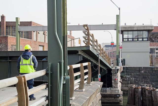
Happy 117th birthday, Grand Street Bridge.

– photo by Mitch Waxman
As part of the nocturnal survey of Newtown Creek one is in the midst of undertaking, a recent evening found the camera perched atop the currently undefended border of Brooklyn and Queens, and a humble narrator lost in a paroxysm of appreciation for the venerable Grand Street Bridge. Not long for this world – as the powers that be have decreed that it shall soon be expensively replaced – this beauty was erected in 1903, replacing an earlier iteration described by the United States Coast Guard as a “hazard to navigation.” The first bridge here was built in 1875, the current version is the third Grand Street Bridge.
Grand Street Bridge is the property of the City of New York, specifically the Department of Transportation. It connects Grand Avenue in Queens with Grand Street in Brooklyn. It’s found 3.1 miles back from the East River’s junction with Newtown Creek, sits at the demarcation point of two Newtown Creek tributaries – the East Branch and English Kills – and is a movable “swing bridge” which sits on a mechanical turntable that rotates the bridge ninety degrees to allow maritime egress.

– photo by Mitch Waxman
The western sidewalk of the bridge doubles as a bike path, which few bicyclists actually use, seemingly preferring to just use the vehicle lanes. Heavily trafficked by MTA buses going to and from their Grand Avenue Bus Depot on the Maspeth, Queens side, the bridge is narrow and a causal factor in many of the traffic problems experienced in Maspeth, Ridgewood, East Williamsburg, Bushwick, and eastern Greenpoint. This is due to the narrowness of the thing, which modern trucks cannot cross two abreast. Instead, drivers wait for traffic to clear the span, which causes backups that stretch for multiple blocks.
Even late at night, when these shots were gathered, it was quite a bother finding a 30 second interval without a heavy vehicle crossing. The Grand Street Bridge shakes and shimmies when even a passenger car crosses it, whereas the passing of a bus or a garbage truck triggers a local bridge quake. Said vibration is ruinous for a tripod mounted camera.

– photo by Mitch Waxman
Next up on my 2020 survey of the Newtown Creek will be the extreme eastern side of the waterway, followed by a series of walks down the visually miserable Brooklyn side of it. The reason it’s miserable is that are so few places where you can access or even view the water, as opposed to the Queens side where – as you’ve seen in recent weeks – there are multiple points of view worth looking at. Hopefully this is something I can find the time and opportunity to accomplish in the next couple of weeks.
Tomorrow, something different at this – your Newtown Pentacle.
“follow” me on Twitter- @newtownpentacle
Buy a book!
“In the Shadows at Newtown Creek,” an 88 page softcover 8.5×11 magazine format photo book by Mitch Waxman, is now on sale at blurb.com for $30.
monstrous fruit
Better late than never, huh?

– photo by Mitch Waxman
Apologies, single shot today. One from the archives of the Grand Street Bridge. Back tomorrow with more substantial messaging, complaints, and shaking of fists against the moon.
“follow” me on Twitter- @newtownpentacle
Come on a tour!
With Atlas Obscura – Infrastructure Creek! My favorite walking tour to conduct, and in a group limited to just twelve people! December 14th, 1:30-3:30 p.m.
Click here for more information and tickets!
Buy a book!
“In the Shadows at Newtown Creek,” an 88 page softcover 8.5×11 magazine format photo book by Mitch Waxman, is now on sale at blurb.com for $30.
correlated causeways
Eleven bridges, one creek.

– photo by Mitch Waxman
Pulaski Bridge is the first span you encounter, when you’ve left the East River and embarked on a journey down the fabulous Newtown Creek. A double bascule drawbridge, and electrically powered, the Pulaski Bridge connects 11th street in Long Island City with McGuinness Blvd. to the south in Brooklyn’s Greenpoint. Built in 1954, the Pulaski Bridge is owned and operated by the New York City Department of Transportation or “NYC DOT.” The Pulaski Bridge carries five lanes of traffic, plus a dedicated bicycle lane and a separate pedestrian pathway. It overflies the Queens Midtown Tunnel and Long Island Expressway, as well as active railroad tracks found on Borden Avenue.

– photo by Mitch Waxman
DB Cabin acts as a gatekeeper to the Dutch Kills tributary of Newtown Creek. It’s a railroad swing bridge owned by the Long Island Railroad, and connects two rail yards – the Wheelspur Yard (to the west, or left in the shot above) and the Blissville Yard – across the water. Both rail yards and the bridge itself are part of the LIRR’s Lower Montauk tracks. DB Cabin dates back to the 1890’s and is in a terrible state of repair. The swing bridge’s motors are nonfunctional, which isolates the Dutch Kills tributary from maritime traffic, and from the rest of the Newtown Creek.

– photo by Mitch Waxman
Cabin M is just to the north of DB Cabin on Dutch Kills, and the single bascule drawbridge connects the Montauk Cutoff with the Blissville Yard mentioned above. The Montauk Cutoff is an elevated track which used to provide a connection between the LIRR’s Main Line tracks at the nearby Sunnyside Yards with the Lower Montauk tracks along the north (or Queens side) shoreline of Newtown Creek. The 2020 Capital Plan just released by the Long Island Railroad’s owner – The MTA – includes funding to demolish Cabin M.

– photo by Mitch Waxman
Borden Avenue Bridge is owned by the NYC DOT, and is one of just two retractile bridges in NYC (the other being the Carroll Street Bridge over the Gowanus Canal). Built in 1908 to replace an earlier wooden drawbridge (1868) at the intersection of Borden Avenue and Dutch Kills, Borden Avenue Bridge received extensive upgrades and structural repairs in 2010 and 2011, and had its electronic components destroyed by flooding during Hurricane Sandy. Another round of repairs and upgrades began in 2019, which included asbestos abatement work.

– photo by Mitch Waxman
The Long Island Expressway is 71 miles long, and is operationally managed in three sections. The Queens Midtown Expressway is how it’s owners, the New York State Department of Transportation, refer to the section found between the Queens Midtown Tunnel and Greenpoint Avenue in Long Island City. This section is elevated, rising to 106 feet above the waters of Dutch Kills. The LIE truss pictured above handles some 87.7 thousand daily vehicle trips, or 32 million annually, to and from Manhattan,
– photo by Mitch Waxman
Hunters Point Avenue Bridge is due north west of Borden Avenue Bridge and the LIE truss. It’s a single bascule drawbridge, owned by the NYC DOT. Replacing an earlier wooden draw bridge that was opened and closed by a donkey walking on a wheel, the Hunters Point Avenue Bridge was built in 1910. Back then, it was a double bascule bridge, but a rebuild in the 1980’s simplified the mechanism to a single bascule. The masonry of the bridge is original to the 1910 design.

– photo by Mitch Waxman
The Greenpoint Avenue Bridge is found some 1.37 miles from Newtown Creek’s intersection with the East River, and roughly a half mile from the mouth of Dutch Kills. It’s a double bascule bridge, built in 1987, and owned and operated by the NYC DOT. There have been many Greenpoint Avenue Bridges, dating back to the first one built by Greenpoint’s town father Neziah Bliss back in 1850, but that one was called the “Blissville Bridge.” The Greenpoint Avenue Bridge is a traffic machine, carrying 28.3 thousand vehicle trips a day, or about ten million a year. Most of that traffic takes the form of heavy trucking.

– photo by Mitch Waxman
The brand new Kosciuszko Bridge(s) replaced a 1939 vintage truss bridge that carried the Brooklyn Queens Expressway over Newtown Creek and are found some 2.1 miles from the East River. The NYS DOT is busy putting the finishing touches on the new cable stay bridge’s construction. In addition to the… ahem… high speed traffic lanes of the BQE, there is also a pedestrian and bicycle pathway found on the new Kosciuszko Bridge which connects 43rd street in Queens’s Sunnyside section with Meeker Avenue in Brooklyn’s Greenpoint.

– photo by Mitch Waxman
The Grand Street Bridge is a swing bridge connecting Maspeth’s Grand Avenue in Queens with East Williamsburg/Bushwick’s Grand Street in Brooklyn. 3.1 miles back from the East River, in a section of Newtown Creek once called “White’s Dock,” the NYC DOT have recently announced plans to replace this 1909 beauty – which is actually the third bridge to occupy this spot. Damage from Hurricane Sandy, and the narrow roadways with height restrictions that the bridge offers, have pretty much sealed its fate. It will be missed.
This is where the main spur of Newtown Creek ends, as a note. Directly east is a truncated tributary called the East Branch, and another tributary called English Kills makes a hard turn to the south just before you encounter Grand Street Bridge.

– photo by Mitch Waxman
Metropolitan Avenue Bridge is a double bascule drawbridge that crosses the English Kills tributary of Newtown Creek, and is owned by the NYC DOT. Metropolitan Avenue was originally built as a private toll road in 1813, and the first bridge here was a part of the “Williamsburg and Jamaica Turnpike.” The current Metropolitan Avenue Bridge was built in 1931, although it has received significant alterations in 1976, 1992, 2006, and again in 2015. The 2015 alterations?
You guessed it, Hurricane Sandy strikes again.

– photo by Mitch Waxman
Montrose Avenue Rail Bridge is the final crossing found over the waters of Newtown Creek and its tributaries. Some 3.7 miles back from the East River, it’s the property of the Long Island Railroad and used for freight service on their Bushwick Branch tracks. A truss bridge, or trestle if you must, my understanding of things are that whereas the trackway and parts of the rail bridge date back to approximately 1924… there has been quite a lot of work done on the thing which I have not been able to fully document so rather than fill in blanks with assumptions – I’m just going to say that I don’t know everything… yet.
It’s an active track, it should be mentioned.
“follow” me on Twitter- @newtownpentacle
Buy a book!
“In the Shadows at Newtown Creek,” an 88 page softcover 8.5×11 magazine format photo book by Mitch Waxman, is now on sale at blurb.com for $30.
mustered up
Sometimes, they come back.

– photo by Mitch Waxman
One found himself in Maspeth, just yesterday, whereupon discovery of a large industrial site’s demolition occurred. The site used to be a cardboard box factory (Star Corrugated Box Co. originally and then Cascades Containerboard), which had occupied this plot of land for several generations. The crews from Breeze Demolition were hard at work pulverizing the place, and coincidentally were replacing the plywood construction fencing surrounding it as I wandered by. It’s apparently a “big secret” as to who the new occupants of the land here will be.
I know the secret, and as loose lips sink ships…

– photo by Mitch Waxman
54-15, 55-15 and 56-19 Grand Avenue were acquired recently by a California based company called LBA Realty for $72 million. The deal involves a partnership with another realty company, RXR, to build a four story warehouse large enough for heavy trucks to drive up a ramp for loading and unloading. Statements from the developer indicate that this facility would be ideal for the “last mile” logistics of e-commerce companies. Hmmm.
Wonder what e-commerce company that might be?

– photo by Mitch Waxman
This project represents a fairly frightening intensification of the truck traffic issues afflicting both Maspeth and East Williamsburg, I would mention.
I would also like to change the subject and mention the importance of large continental river systems to human civilizations. The Mississippi, Colorado, and Hudson Rivers come to mind here in North America, as does the Yang Tse and the Ganges in Asia. There’s the Nile in Africa, of course, and the Rhine in Europe.
I’m forgetting a big and important river, I think, one that runs through South America or maybe Seattle? What’s that one called again?
“follow” me on Twitter- @newtownpentacle
Upcoming Tours and Events
Thursday, July 25, 6:30 p.m. – 8:30 p.m.
Greenpoint Walking Tour w NYCH20
Explore Greenpoint’s post industrial landscape and waterfront with Newtown Creek Alliance historian Mitch Waxman.
Click here for ticketing and more information.
Buy a book!
“In the Shadows at Newtown Creek,” an 88 page softcover 8.5×11 magazine format photo book by Mitch Waxman, is now on sale at blurb.com for $30.
dread induced
Better late than never?

– photo by Mitch Waxman
Sorry for the late post, and for the lack of meat on the bone. Back tomorrow with something decidedly more substantial than an abstraction of the superstructure of the Grand Street Bridge over my beloved Creek.
Upcoming Tours and Events
June 15th – Exploring the East River,
From General Slocum Disaster to Abandoned Islands – with NY Adventure Club.
June 15th is one of those days in NYC history. In 1904, more than a thousand people boarded a boat in lower Manhattan, heading for a church picnic on Long Island — only 321 of them would return. This is the story of the General Slocum disaster, and how New York Harbor, the ferry industry, and a community were forever altered.
Join New York Adventure Club for a two-part aquatic adventure as we explore the General Slocum disaster, and historic sights and stories along the East River, all by NYC Ferry.
Tickets and more details here.
“follow” me on Twitter- @newtownpentacle
Buy a book!
“In the Shadows at Newtown Creek,” an 88 page softcover 8.5×11 magazine format photo book by Mitch Waxman, is now on sale at blurb.com for $30.


