Posts Tagged ‘photowalk’
ethereal character

– photo by Mitch Waxman
The launch we were in had been referred to as the “tin boat” by the Riverkeeper folks, but it was more a smallish rowboat with an outboard engine than anything else. This is the second post of this adventure, click here for the first one.
We had just passed beneath the two rail bridges which vouchsafe and isolate Dutch Kills from the main body of the Newtown Creek, and were heading in the general direction of Queens Plaza when we approached the Borden Avenue Bridge.

– photo by Mitch Waxman
Of course, this century old structure has recently undergone a radical schedule of repairs when it was discovered that one of its abutments had begun to shift, and no small amount of complaint arose at the inconvenience from the legions of truckers and ordinary drivers who mourned its unavailability.
Down on the water however, things were pretty intense, from a purely existential point of view.

– photo by Mitch Waxman
Those bubbles of gas mentioned in yesterday’s post, which were erupting even when the water was unmolested by our passing, delivered a slightly petrochemical smell when they burst. Another member of the Newtown Creek Alliance who was sitting next to me in the boat began muttering “Oh my god” over and over at this point in time.
It wasn’t fear in his eyes, it was disbelief.

– photo by Mitch Waxman
My companion was no virgin or first time visitor to the Creek, of course, in fact his experience of the place is broad and far reaching. When all of your senses get involved with the atmosphere of ruination here, however, one tends to become a bit overwhelmed as your brain attempts to interpret and process the impossible data it is presented with.
The canalized bulkheads of Dutch Kills also tower over you from the water level, creating a sense of forced perspective and inevitability.

– photo by Mitch Waxman
The first thing you see when passing the Borden Avenue Bridge is an archaic sewer outfall, and were the brush not at it’s mid summer height, one would observe the shanty home of the Blue Crow above.
For those of you not familiar with this term, Crow is a name assigned in my little section of Astoria to the myriad metal and refuse collectors known to haunt the neighborhood on “Bulk Pickup Day”. Leave something shiny on the sidewalk, a crow will sweep in and grab it.
Metals are collected and sold by the pound in the scrap and recycling markets of Greenpoint and Long Island City, and these guys make their living from hunting and gathering. I assign them color names based on vehicle, or clothing choices.
There’s also a red crow out there.

– photo by Mitch Waxman
Here is a winter shot from road grade level which shows the sewer and the ever expanding hut of this particular crow. There is a photo of him to be in this Newtown Pentacle posting from February of 2010. Don’t be mistaken, I am not insulting either his industriousness or tenacity, if I were in a similar situation things would go far worse for your humble narrator. This man has been surviving in what has to one of the world’s most extreme environments for years now, and rent free.

– photo by Mitch Waxman
Looking back toward the Borden Avenue Bridge, the ominous humming which echoed along the bulkheads and emanated from above signaled that we had passed under another of the bridges of Dutch Kills. This bridge was built high, and called an expressway by Robert Moses himself.

– photo by Mitch Waxman
Some 106 feet over road grade, the high flying Queens Midtown Expressway leg of the larger Long Island Expressway feeds into the yawning mouth of the Queens Midtown Tunnel less than a mile from here. I call this part of Dutch Kills DULIE, or Down Under the Long Island Expressway.
One of the common complaints heard by eastern bound commuters in the early days of the 20th century was about the horrible smells they encountered when crossing through Long Island City. Moses built his auto bridge as high as engineering and budgetary considerations allowed in response to the plume of industrial outgassing which distinguished a trip through the area in his time.

– photo by Mitch Waxman
Dutch Kills is a particularly important tributary of the Newtown Creek, from an industrial history point of view. What is today a relict of brown fields, industrial spills, and toxic leave behinds was once the economic and manufacturing heartland of New York City. The heavy infrastructure here is no accident, and the waterway was a critical feature that drew one of the great (and largely forgotten) men of Queens to the Waste Meadows at the start of the early 20th century.

– photo by Mitch Waxman
At the end of the 19th century, none of this was here. Sure, there was a muddy road made of creosoted wood blocks and riprap bulkheads called Hunters Point Avenue which ran between isolated industrial sites, and a slightly more modern causeway called Borden Avenue which hosted a few large operations, but this was a swampy and pestilential bog. Brackish creeks wound along knolls of marsh grass and the stubby trees held together mud islands.
The place was lousy with all the junk floating down from Blissville and the sewers in Brooklyn and only Mosquitos and ticks found the place hospitable.
Dutch Kills needed to be fixed.
– photo by Mitch Waxman
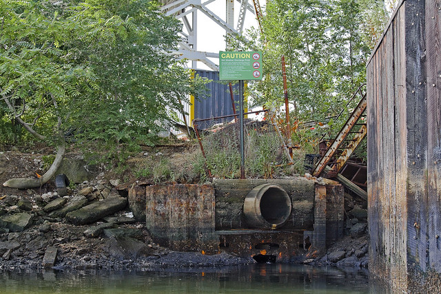
Another sewer outfall is found directly after passing the LIE’s massive footing, which is the sort of improvement that benefited somewhere else rather than Dutch Kills. It was decided by the city fathers in the first years of the 20th century that something had to be done with these swampy wetlands, so close to Manhattan and the gold coast of the Newtown Creek.
Something was needed- a plan with vision, executed by someone who understood the byzantine politics of Tammany Hall and the recently consolidated City of Greater New York. Additionally, it would have to someone with proven “know how” who could “get it done”.

– photo by Mitch Waxman
From the mid 1930’s on, that person would have been Robert Moses. The ultimate political fixer, Moses employed the greatest engineering minds of a generation to shape and design our modern City. While Moses was still in diapers, however, no shortage of great men existed in the City. A plan was presented, and approved, and in both Albany and Washington- strings were pulled by the Tammany men and budgets were approved.
The Army Corps of Engineers were assigned here to canalize, deepen, straighten and erect industrial bulkheads at Dutch Kills in 1914. Land was reclaimed by dumping the fill and spoils produced by the digging of the Belmont Subway Tunnels (leading to to Manhattan) amongst wooden pilings driven deeply into the mud.
The modern shoreline of Queens began to assume it’s current shape.

– photo by Mitch Waxman
It is apparent what happened here, when you see the Hunters Point Avenue Bridge appear before you.
Progress had arrived in Queens, and his name was Michael Degnon.
ponderous and forbidding

– photo by Mitch Waxman
As mentioned in a post the other day, an opportunity arose for me to accompany a representative of Riverkeeper on a survey mission to Newtown Creek recently.
Demanded by the top leadership of the Newtown Creek Alliance itself, this was an expedition whose agenda would require the photographic documentation of bulkheads and shoreline conditions all along the Creek. Of special interest to those involved in the renewal and resuscitation of brownfield sites, the mission as put forward was to get a shot of everything possible. This survey would include observation of the lesser known tributaries of the Creek- Dutch and English Kills, as well as Maspeth Creek, and the East and West Branches which lie beyond the Grand Street Bridge.

– photo by Mitch Waxman
The barriers which guard the secrets of Dutch Kills, which branches from the main body of Newtown Creek just .8 of a mile from it’s locus point with the East River, are two rail bridges. As mentioned in the past, I am no expert on the intricacies of the trackways which snake around the Queens side of the Creek. The expert on this subject was Bernard Ente, who recently passed away, and I wouldn’t offend his memory by pretending to know more than the following:
Neither Bridge (both are moveable) has opened for some time, and it is my understanding that they are part of the “Montauk Cutoff”.

– photo by Mitch Waxman
The survey team was small, as we were in a tiny craft. Hardly more than a rowboat with an outboard motor, three of us sat less than a few inches above the water. There was a mist hanging in the air, as it was early morning, which was quite invisible to the eye but will occasionally become visible in these shots (when I fired off the flash).
Our plan was to take advantage of high and low tides to gain access to the various sections which we were mandated to record, and the low ceiling of the swing bridge at Dutch Kills demanded we make our attempt at ebb tide and exit the tributary before it again flooded.

– photo by Mitch Waxman
I will admit to prayer that a train might pass overhead, for this would be a prize photo for your humble narrator, but alas- no such luck. I don’t know very much about the rails, but I do like taking pictures of trains from odd angles. There was a ghastly sensation afoot in me as well, as I knew that the very air which we were breathing was a hideous miasma of vapor emissions rising from the poison sediments which line the bed of Dutch Kills.
Everywhere, there were tiny bubbles erupting to the surface of the water, and as we disturbed them- mephitic smells swirled about and enveloped the boat.

– photo by Mitch Waxman
Many times have I been down Newtown Creek on the water, but it has always been in nothing smaller than a NY Water Taxi. Additionally, Dutch Kills is “mine”, a branch of the Creek that has received extensive study and historical analysis here at Newtown Pentacle as well as having been thoroughly catalogued photographically. No surprises in store here thought I, English Kills is a bit more “unknown territory” and would likely yield something to hang my hat on.
That is what I thought at the start of this trip.

– photo by Mitch Waxman
To start, the first rail bridge seems to be in a deep state of corrosion, which would make sense given its century long existence. I am no engineer, of course, but this thing hasn’t seen a paint brush in a very long time.
Witnessing the rust and metal fatigue on this bridge actually made me glad that a train wasn’t passing by overhead. The works and motors which power this bridge’s swing action have been burnt out for some time I am told.

– photo by Mitch Waxman
I have never seen it happen (as you would have seen a photo of it here by now) but word is that if the bridge needed to be opened, rail workers would utilize the sort of tow trucks known as “wreckers”, situated at both banks, to winch the thing open.
Sounds bizarre, but the aforementioned Bernard Ente told me that one, and “Bernie was always right” about this sort of thing. Can’t tell you how many crazy stories he would tell me about the history and lore of this place, which my own research would prove him to have been purposely understating.

– photo by Mitch Waxman
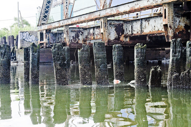
All across Dutch Kills, everything bore that unmistakable colour which typifies the lament and sickness of the Newtown Creek watershed. Iridescent, it is neither black nor white nor any normal color, rather it’s is like something alien coating everything in rotten decay. Metal corrodes, wood molders, stone and cement simply crumble away.
The swampy wetlands which existed here in aboriginal times were known as the Waste Meadows in the 19th century, and perhaps this is still the appropriate terminology for them.
– photo by Mitch Waxman
Pilings and structural elements squamously protrude from the water, whose surface seems thicker than expectation would predict. Normal fluid dynamics apply of course, but the turgid waves behaved in the manner of a broth or syrup as opposed to the more wholesome (but still polluted) water found on the nearby East River.
Additionally, high tide was not marked by invertebrate communities of barnacles or mussels here, but rather by tree ring like deposits of sediment.

– photo by Mitch Waxman
Looking back toward the swing bridge, in the direction of infinite Brooklyn, a long walkway is attached to the pier which the bridge is anchored into.
One thing which I can categorically show in these “bulkhead survey” shots of the Newtown Creek, is that much of the so called land along the Queens bank of the Creek (and large parts of English Kills in Brooklyn) is actually an engineered surface of pilings intermixed with fill and capped with a cement slab- reclaimed land.
One of the scarier ramifications of this, and again– not an engineer- is witnessed in the deleterious condition of these century old wood pilings visible from the water’s edge.

– photo by Mitch Waxman
Next up on this trip is the truss rail bridge, which is built quite a bit higher in elevation than the initial structure and is found at the other side of the pier and walkway which connects to the Swing Bridge. It’s a drawbridge, and the elevated height must have been part of a plan to reduce the need to open the span for water traffic on the once busy Dutch Kills.

– photo by Mitch Waxman
Apologies are offered for vagueness, lords and ladies, as I fear that I’ve spoiled you over the last several years with vulgar displays of “info-porn”. Normally, you’d be reading stats and figures, hearing the name of engineers and learning of long forgotten disasters. Unfortunately, as these two bridges are not publicly accessible, and to study them in any real detail would mean trespassing and demand mandatory jail time… these are the bridge structures which I can describe in the least detail anywhere along Newtown Creek.
Railfans of NYC, anonymous LIRR employees, please leave a comment below and share the wisdom.
As mentioned in the past- I never trespass- like a Vampire your humble narrator needs to be invited inside to do his best work and in the age of terror- no one is invited to look too closely at railroad infrastructure.

– photo by Mitch Waxman
Others, however, are not as constrained as I.
A garish banner caught my eye as we passed beneath the truss bridge. My mind concocted that I was seeing just another windblown tarp or plastic container bag at first, but then as we approached… I realized that it was some kind of painting.

– photo by Mitch Waxman
Hung at a level which allows it to interact with the high tide level, this painting seems to depict- to my eye- a middle eastern city withering in flame beneath the burning thermonuclear eye of god.
What’s more, for once, I can brag to Ms. Heather, over at ny-shitty.com, that I finally got something before she did.
Note: as always, clicking the photo will open a new window at Flickr. Clicking the view all sizes option under the “actions” tab will take you to ever larger incarnations of the shot for closer examination. If anyone knows who the artist is, or what this situation is about, I’d love to hear about it.

– photo by Mitch Waxman
It would seem that someone has set up camp under here, or perhaps it is just a studio space. The undocumented men and women who live in both these “Waste Meadows” -and the Newtown Creek watershed as a whole- are too numerous to count. Many are exactly where they belong, while others are trapped by circumstance and ill omen.
All need to be coaxed away from this place, before the Creek does to them what it has to so many others in Greenpoint and Long Island City.

– photo by Mitch Waxman
No human being should be living in this place, except as part of a penal sentence for an especially heinous offense. Trolls live under bridges, not Americans. Additionally, in the age of terror, how exactly does this go unnoticed by the gendarme?
I cannot stress how often I ask this question as I wander across the Creeklands.

– photo by Mitch Waxman
Despite the fearful atmospherics and forbidding appearance of the water, we pressed on. Our steward from Riverkeeper kept a steady hand on the outboard motor and the tiny boat slid forward across Dutch Kills. This shot is looking back at the two rail bridges of the Montauk Cutoff which we had just passed beneath.
Still no trains.

– photo by Mitch Waxman
Dead ahead was the Borden Avenue Bridge and the high flying Long Island Expressway, the experiencing of which which will be discussed tomorrow at this- your Newtown Pentacle.
unnumbered crimes

– photo by Mitch Waxman
note: despite the title, this a “just the facts” brand posting
Cortlandt Alley is a vestigial connection between Franklin and Canal Streets in Manhattan, crossing White and Walker on its path. If it looks familiar, it should, as many commercial photographers utilize the location for its noir aesthetics and patois of urban decay. One may often observe a shoot going on here, a sharp contrast to the sort of lurid business which one might have seen on this street a mere twenty years ago (which discouraged the presence of cameras).
Today, my focus turns to an enigmatic structure on the corner of Walker Street and Cortlandt Alley.

– photo by Mitch Waxman
According to the best sources I could find, Walker Street was scratched onto the maps of New York sometime in 1810. Pavement came along in 1819, and by the 1870’s a street railway connected the area (via West Broadway) to the far distant East River. This was considered a near suburb in those hoary days of the early middle 19th century, and this was fairly close to if not the actual border of the Bloody Sixth Ward (I’ve seen conflicting accounts describing the borders of the 6th ward).
All accounts agree that this area, known as “Tribeca Historic District” in modernity, served the city as a mercantile center which took advantage of the ample docks on the nearby North (Hudson) River for the importation of foreign goods.

– photo by Mitch Waxman
The intriguing (and officially Landmarked) Latimer Building was raised sometime between 1860 and 1862 for developers Barret Ames and E.D. Hunter. Municipal sources indicate that it stands on land once occupied by a part of the legendary Florence’s Hotel, whose main address was on the confluence of the North side of Walker with Broadway. Supposition is also offered by these selfsame governmental entities that the “Latimer” indicated by the cornice art would have been a fellow named Edward Latimer, a SOHO merchant- although I haven’t been able to confirm this independently.

– photo by Mitch Waxman
The modern occupants of the building follow a historical pattern of tenancy by garment manufacturers, book publishers, and building trade jobbers. A “jobber” is a company or individual who imports and resells manufactured goods, and offers installation and delivery services for the materials they handle.

– photo by Mitch Waxman
Occupying 72-76 Walker Street, the Latimer is a relict and vestige of New York’s industrial past. Single floor factory operations and garment assembly shops- sweat shops as they were and are known- once provided occupation and employment for large numbers of immigrant poor. In my own family, certain individuals who enjoyed an exalted peer status and exhibited financial success were “pattern cutters” and “dock foremen” and employed nearby, while others (like my own grandmother) were “sewers”. One of my Aunts actually worked at Triangle Shirtwaist.
Back then, this was an overwhelmingly jewish industry. Modern day economics seems to favor the presence of Asian and Latino work forces, as the earlier ethnic laborers have moved on to explore other synergies.

– photo by Mitch Waxman
The Cortlandt Alley side of the Latimer exhibits the “fireproof window doors” once common in the days before sprinkler fire suppression systems became mandatory in such structures. Additionally, iron rails and reinforced concrete still extant point out that there was once a loading dock on the Alley side which has disappeared sometime in the intervening decades since the completion of the building in 1860. The fire escapes are a later addition, of course, which were mandated by the precursor of the FDNY sometime in the late 19th or early 20th centuries.

– photo by Mitch Waxman
The grand appearance of the building is somewhat muted at street level, and it blends into the dark melange of relict buildings and ancient tenements which typify the parts of Manhattan just North and West of “Chinatown”. The age of Walker Street is betrayed by not just by its narrow bed, but by belgian blocks bursting through modern asphalt and the occasional stone curbs which still line it.

– photo by Mitch Waxman
The charming ambience of the “old days” has rendered many of these former industrial spaces into mixed use buildings- and many of them are now the exclusive and dearly held apartments of millionaire dilettantes. According to one Forbes magazine report in 2006, this was the most expensive section of New York City in which one might seek domestic housing.
exceeding magnitude

– photo by Mitch Waxman
Recently, an invitation to attend a lecture offered by a prominent maritime scholar drew both myself and the Newtown Pentacle’s far eastern correspondent Armstrong to lower Manhattan. Early for the evenings presentation, we decided to wander aimlessly around the imposing edifices of the municipality and see what we could see. St. Andrew’s Roman Catholic Church drew attention to itself and since I had never visited the celebrated structure, we approached and entered the Georgian Revival church.
from wikipedia
The Church of St. Andrew is a Roman Catholic parish church in the Roman Catholic Archdiocese of New York, located at 20 Cardinal Hayes Place, Manhattan, New York City. It was established in 1842 and has been staffed by the Blessed Sacrament Fathers ever since.
In 1892, the address listed was on Duane Street, and the corner of City Hall Place.
The present building was erected in 1939 through a joint effort involving the famous Boston firm Maginnis & Walsh and Robert J. Reiley of New York. It is one of the best examples of the Georgian Revival architectural style in New York. St. Andrew is the only New York City church to be designed by Maginnis & Walsh.

– photo by Mitch Waxman
Subsequent antiquarian research revealed that the site was originally a “friends” or Universalist meeting house, and had been acquired by the then struggling Roman Catholics for use by the surging tide of congregants arriving into Manhattan, some from war ravaged southern Germany but most were arriving from famine stricken Ireland. The stately appliances and forbidding iconography of lower manhattan were not in place yet, and this neighborhood had an entirely different character. This was the worst slum on earth, more crowded than Bombay and twice as dangerous, according to Charles Dickens.
The Five Points and the infamous Old Bailey were nearby, the legendary Collect Pond was across the street, and despite Dagger John Hughes being a mere Bishop during this period- he had already seen the need for expansion.
from nycago.org
The Roman Catholic parish of St. Andrew was established in 1843 when Father Andrew Byrne transformed Carroll Hall into St. Andrew’s Church. Built in 1818 for the Congregational Society of United Christian Friends, Carroll Hall was, in 1841, the site where Catholics rallied to fight denial of public funding for parochial schools. Father Byrne was the pastor until 1844, when he was named the first bishop of the new Diocese of Little Rock, comprised of the entire State of Arkansas and all of the Indian Territory, and was consecrated that year in St. Patrick’s Cathedral. Cardinal Patrick J. Hayes, for whom the church’s street was renamed, was born in a house next door to St. Andrew’s Church, and was baptized here in 1867.
Tragedy struck the church in 1875 when, during a severe storm, the building next door collapsed, causing the ceiling of the church to drop onto 1,200 who were attending an evening mass during Lent. Many were killed or wounded, and a panic ensued because the main entrance of the church was locked.
In 1900, Father Luke J. Evers began a 2:30 am Mass for night workers who were employed in the nearby Printing House Square, where the Sun, Telegraph, Times, and World newspapers were then published. This tradition continued for more than 50 years, and the church became known as “The Printers’ Church.”

– photo by Mitch Waxman
St. Andrew, according to several variants and doctrinal versions, is meant to have been a disciple of John the Baptist and brother of the apostle (and church founder) Simon Peter. He’s the patron saint of Scotland, and of the Patriarchate of Constantinople. The X shaped device he bears is the instrument of his death by crucifixion, and the legends say that he pleaded with the Romans not to crucify him in the same manner as Jesus (as he was unworthy of the honor) so they used the X or Crux Decussata configuration instead of the T.
It should be pointed out that the Romans were not known for granting last requests in those days, and that this iconography emerged only in the late middle ages according to scholarly sources.
from A history of the churches, of all denominations, in the city of New York 1846, courtesy google books
St. Andrew’s Church.
In the year 1840, another Catholic Church was formed, called ” St. Andrew’s Church,” under the pastoral charge of the Rev. John Maginnis. A house of worship, originally built by a Universalist Society, situated on Duane street, near Chatham, was purchased, and here they remain.

– photo by Mitch Waxman
The interior of the church was staid and tasteful, and there were a couple of people praying so I kept to the side. There were beautiful confessional booths set into the walls, exquisitely carven and tastefully placed, but as the light was quite dim within the church – and not wanting to disturb the parishioners- I decided against setting up a tripod to do a long exposure shot.
The image above and below were gathered by merely laying my camera down on the pews instead to accomplish the long shutter speed’s need for stabilization.
There was a feeling of emptiness, a quiet void, within the building- it was the quietest corner of Lower Manhattan I’ve experienced to date. The thick walls and heavy doors insulated the place from all but the loudest exhalations of the constant outside tumult.
from A brief sketch of the early history of the Catholic Church on the island of New York, 1870, courtesy google books
The year 1841 was made famous in the history of Catholicity in New York by the agitation of the “School Question,” as it was called. Previous to that time, the public instruction had been in the hands of a close corporation, under the title of the Public School Society, which administered and distributed, according to its own good pleasure, the funds provided by the city for the purpose of education.
The books used in these schools abounded with the usual stereotyped falsehoods against the Catholic religion, and the fnost vexatious and open system of proselytism was carried on in them. The evil became finally so great, that no alternative was left for Catholic parents but either to prevent their children from attending the schools at all, or to cause an entire change to be made in the system; under the advice and active leadership of the Bishop, a systematic attempt was made to call the attention of the community and public authorities to the subject, and after a severe contest it resulted in the establishment of the present Common School system.
The Bishop delivered two lectures upon the subject in Carroll Hall, but one of the most triumphant defences of the principle contended for by the Catholics was made by him in a speech before the Common Council of New York, in which he replied to the arguments of Messrs. Ketchum and Sedgwick, who had been employed by the Public School Society as their counsel, and also to Dr. Bond, Dr. Spring, and others who had volunteered in its support.
Experience has since shown, however, that the nw system, though administered with as much impartiality and fairness as could be expected under the circumstances, is one which, as excluding all religious instruction, is most fatal to the moral and religious principles of our children, and makes it evident that our only resource is to establish schools of our own, where sound religious knowledge shall be imparted at the same time with secular instruction. If we needed any evidence upon the matter, it would be found in the conduct and behavior of those of our children who are educated under the Christian Brothers, when contrasted with those who are exposed to the pernicious influences of a public school.

– photo by Mitch Waxman
Dagger John Hughes, through no fault of his own, is the reason why education in the City of New York is both secular and overseen by a municipal agency. His determination to have anti Catholic rhetoric removed from the curricula of the Public School Society, and the controversy surrounding the issue, resulted in an 1842 decision by the State Government in Albany to form the Board of Education of the City of New York.
from Harper’s magazine, Volume 40 1870, courtesy google books
The Public School Society ceased to be the almoner of the public moneys.
Principle forbade that the State should become tributary to the hierarchy. Policy forbade that it should leave the grievances of the Church, real or imaginary, wholly unredressed. A middle course was adopted. Once, at least, in the history of legislation a compromise has resulted in the adoption of a permanent and beneficent principle.
A Board of Education was appointed for the city of New York.
All public funds were placed in their hands for distribution. The schools of the Public School Society were among those named in the act as entitled to share in the distribution of this fund. No school in which any religious sectarian doctrine or tenet should be taught might have the same privilege. Such, in a sentence, was the school law of 1842. For its existence the State owes an incalculable debt of gratitude to two ecclesiastics, either of whom would have bitterly opposed it to the last.
That the school system of New York city is a system, that education is no longer doled out as a charity to the poor, either by the Churches or by philanthropic societies, but is awarded to all, as a right, by the State, is due largely, if not chiefly, to the unintentional offices of Rev. Jonathan Chase and Archbishop Hughes, who succeeded in promoting the very legislation which they were most desirous to prevent.

– photo by Mitch Waxman
Anti Catholic bigotry is what Dagger John called it, and it was decided that the Catholic Church would need to set up its own schools- parochial schools- where Doctrine would be part and parcel of the lesson plan. Great Universities and thousands of schools would be founded within just a few years, but the soon to be Archbishop Hughes already had his gaze fixed upon his next great project.
A large parcel of land in Queens would be acquired to house the mortal remains of his ever expanding flock. This land- found along the Newtown Creek- he would consecrate it as his Calvary Cemetery.
from wikipedia
He was consecrated bishop on January 7, 1838 with the titular see of Basileopolis. He succeeded to the bishopric of the diocese of New York on December 20, 1842 and became an archbishop on July 19, 1850, when the diocese was elevated to the status of archdiocese.
Hughes, influenced by the reactionary stance of Pope Pius IX, was a staunch opponent of Abolitionism and the Free Soil movement. In 1850 he delivered an address entitled “The Decline of Protestantism and Its Causes,” in which he announced as the ambition of Roman Catholicism “to convert all Pagan nations, and all Protestant nations . . . Our mission [is] to convert the world—including the inhabitants of the United States—the people of the cities, and the people of the country . . . the Legislatures, the Senate, the Cabinet, the President, and all!”
He also campaigned actively on behalf of Irish immigrants, and attempted to secure state support for religious schools. He protested against the United States Government for using the King James Bible in public schools, claiming that it was an attack on Catholic constitutional rights of double taxation, because Catholics would need to pay taxes for public school and also pay for the private school to send their children, to avoid the Protestant translation of the Bible. When he failed to secure state support, he founded an independent Catholic school system which was taken into the Catholic Church’s core at the Third Plenary Council of Baltimore, 1884, which mandated that all Parishes have a parochial school and that all Catholic children be sent to those schools.
escaping forever

– photo by Mitch Waxman
There is just so much to do.
This weekend, as in Saturday the 13th, Forgotten-NY strides confidently into Long Island City for a walking tour of Hunters Point. The inestimable local historian Richard Melnick will be assisting the titan intellect called Kevin Walsh with narration and sartorial anecdote, and I will be scuttling around the crowd. Additionally, I did the photography which will appear in the complimentary tour booklet.
Address your clicking to this link for more information from forgotten-NY on the Hunters Point walking tour.

– photo by Mitch Waxman
Last weekend, your humble narrator was onboard when Riverkeeper conveyed a nervous group of interested civilian observers into the languishing mists of the occluded Newtown Creek. Opportunities to explore the Creek like this are rare, even for those of working for the Newtown Creek Alliance (which is how I ended up on the boat), and hazardous to both physical and mental health. We explored several of the more malign tributaries of the great urban waterway in a small rowboat outfitted with an outboard motor, and experienced things that left all shaken.
Several hundred photos of the expedition will be made public and available for sorting and inspection within the next few days, and they will exhibit a level of environmental ruination -perhaps too terrible to live with- for those who would dare to look. Certain knowledge cannot be unlearned, after all, and for many- ignorance is preferable to living with such facts.

– photo by Mitch Waxman
Additionally, efforts on behalf of the Working Harbor Committee continue as we ramp up to the Great North River Tugboat Race. Of course this event will be happening while the WHC “Hidden Harbor” schedule is underway.
The Hidden Harbor ticketed tours:
- Brooklyn: Detailed narration on and about the historic shoreline from Newtown Creek to the Gowanus Canal.
- Newark Bay: explore the industrial corridor of the harbor along the Kill Van Kull (aka “Tugboat Alley”) and witness Port Elizabeth Newark.
- North River: the Hudson, it’s former industrial might and bright future.
- Specialty tours like my own “Newtown Creek” tour, and the “Light Houses” tour.
- Other private events designed for the benefit of both students and Seniors.
The great North River Tugboat Race will be held on September 4th, and there are limited seats available on the Circle Line observer boat which will be pacing the action as best as it can manage. On Pier 84 (foot of west 44th street in Manhattan at the Hudson River) there will also be free events and fun, including a rope throwing contest, best sailor Tattoo, and a Spinach eating contest.


