Archive for the ‘Brooklyn’ Category
formula filled
My creek also puts on a show when I’ve been away from her too long.
– photo by Mitch Waxman
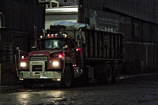
One of my practices, developed over the last decade or so, is to take a Newtown Creek break periodically and “allow my liver to return to a normal size.” I’m joking about the liver, but one does enjoy a bit of detox occasionally, and allowing the poisons I’ve accrued a chance to leach out. This is a luxury one enjoys, as he doesn’t live along Newtown Creek, others aren’t so lucky. Pictured above is roll on/ roll off garbage truck carrying a bin, spotted at a waste transfer station owned by a friend of mine which fairly straddles the border of Brooklyn and Queens.
– photo by Mitch Waxman
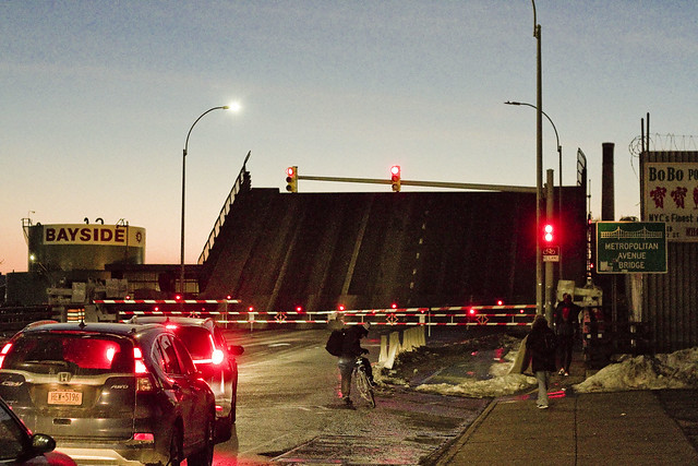
Marching along Metropolitan Avenue, one squealed with delight as the Metropolitan Avenue Bridge began to open. This used to be quite a frequent occurrence “back in the day.” These days there’s only one regular maritime customer back here on the English Kills tributary, which is Bayside Fuel.

– photo by Mitch Waxman
The timing of the bridge opening was bizarre, occurring at precisely the time of one of the heaviest traffic intervals in this section of North Brooklyn, about 6:30 p.m.

– photo by Mitch Waxman
That odd timing, however, allowed one to stand in the middle of Metropolitan Avenue without getting squished.

– photo by Mitch Waxman
I believe that the tug pictured above is the Mary H., which normally handles the Bayside duty, but it’s hard to say as I didn’t get any of its markings. I did manage to focus in on the captain in his wheelhouse, however, so “win.”
As a note, the Metropolitan Avenue Bridge spans the English Kills tributary of the larger Newtown Creek at a navigational mark 3.4 miles eastwards of the East River. Metropolitan Avenue was originally created as a private toll road about 1814, and was called the Williamsburgh and Jamaica Turnpike. The owners of the toll road, and the original bridge, were two brothers whose family name was Masters. That’s why you’ll occasionally see references to the road as the “Masters Turnpike” and the “Masters Bridge” in the historical record, if like me, you stay up until 4 in the morning reading old municipal journals and reports from the Chambers of Commerce of Brooklyn or Queens.

– photo by Mitch Waxman
My conceit is to call this area of Newtown Creek surrounding the Metropolitan Avenue Bridge “DUMABO.” That’s short for “Down Under the Metropolitan Avenue Bridge,” as I believe we need to be ahead of the real estate people on these sorts of things.
“follow” me on Twitter- @newtownpentacle
ignorantly spared
Back on the job.

– photo by Mitch Waxman
Since the recent extreme cold spell has broken, a humble narrator has found himself marching about again, and boy are my dogs barking. On Tuesday, a stroll over to Bushwick East Williamsburg was enacted and the farthest reaches of the Newtown Creek at English Kills were observed. As expected, the waterway was frozen over.

– photo by Mitch Waxman
Toxic ice. You don’t get to say that particular phrase that too often, but that’s what you’re looking at in the shot above. English Kills is the far eastern terminus of Newtown Creek, which branches off of the East River nearly 3.8 miles from the larger waterbody. These shots were gathered at about 3.7 miles back.

– photo by Mitch Waxman
That big sewer outfall at the end of the tributary is the 3.8 mile terminus mark, and the north/south street seen beyond the fencelines is Johnson Avenue. The surrounding neighborhood is gentrifying (dictionary definition of gentrifying), but on a fairly small scale as compared to points found to the west like LIC and Greenpoint.

– photo by Mitch Waxman
One decided to hang around the neighborhood for a bit and stretch my legs after the long interval of being trapped in the house by inclement clime, and visit a few of my favorite places. This shot is from the Scott Avenue footbridge, which spans the LIRR’s Bushwick Branch freight tracks, just as the burning thermonuclear eye of God itself was dipping behind New Jersey to the west.

– photo by Mitch Waxman
Heading over towards Metropolitan Avenue, and another of the dead end tributaries of Newtown Creek – the East Branch, one discovered that this section of the water was similarly locked in a decidedly polar state.

– photo by Mitch Waxman
The ice was decaying faster in both waterways where it touched the open sewer outfalls, no doubt due to the flow of melt water laden with road salt coming in from as far away as Canarsie. This untreated sewage is quite biologically active as well, and the metabolism of the microscopic entities contained in the water column likely helps to warm it up a bit.
“follow” me on Twitter- @newtownpentacle
familiar rookery
It’s National Eat a Red Apple Day, in these United States.

– photo by Mitch Waxman
The holiday season arrives at Newtown Creek in a manner alien to the neighborhoods surrounding it.
Hereabouts it’s truck tires roasting on a open fire, and that ain’t Jack Frost nipping at your nose kiddo, it’s benzene. Reviewing my year end list of; all the mistakes I’ve newly made, people I’ve offended, stupid things I’ve said in public, or generally humiliated myself somehow – it occurred that I hadn’t checked in on things in DUKBO (Down Under the Kosciuszcko Bridge Onramp) in about a month.
That’s the scene, above, at the spot where Review Avenue transmogrifies into Laurel Hill Blvd. at Penny Bridge, in the Blissville section of Long Island City, in the Borough of Queens.

– photo by Mitch Waxman
Long time readers of this – your Newtown Pentacle – will tell you that this bridge replacement project has been explored before.
Documenting this project has been a long standing project of mine – this 2012 post tells you everything you could want to know about Robert Moses, Fiorella LaGuardia, and the origins of the 1939 model Kosciuszcko Bridge. Just before construction started, I swept through both the Brooklyn and Queens sides of Newtown Creek in the area I call “DUKBO” – Down Under the Kosciuszcko Bridge Onramp. Here’s a 2014 post, and another, showing what things used to look like on the Brooklyn side, and one dating back to 2010, and from 2012 discussing the Queens side – this. Construction started, and this 2014 post offers a look at things. There’s shots from the water of Newtown Creek, in this June 2015 post, and in this September 2015 post, which shows the bridge support towers rising. Additionally, this post from March of 2016 detailed the action on the Queens side. Most recently, here’s one from May of 2016, and one from June of the same year. Here’s one from August of 2016, the December 2016 one, one from March of 2017 which discusses the demolition of the 1939 bridge.
Here’s a post showing what I saw during a pre opening walk through in early April of 2017, and the fanfare surrounding the opening of half of the new bridge in April of 2017, a walk through of the Brooklyn side job site in June of 2017. Here’s some night shots from early July of 2017. A series of posts focused in on the removal of the central truss of the 1939 bridge from the summer of 2017 – a timelapse, some stills, and the barging out of the truss.
Most recently, in late September of 2017, a final series of shots of the old bridge were captured in this post. Acquisition of a souvenir chunk of steel from the 1939 bridge was described in this post, and a video of the “energetic felling” of the approaches on October 1st was offered in this one. Still shots and views of the aftermath from the waters of Newtown Creek from later in the day on Oct. 1 are found in this posting, and the aftermath of the demolition as seen from Calvary Cemetery in LIC’s Blissville section in this post from October 5th.

– photo by Mitch Waxman
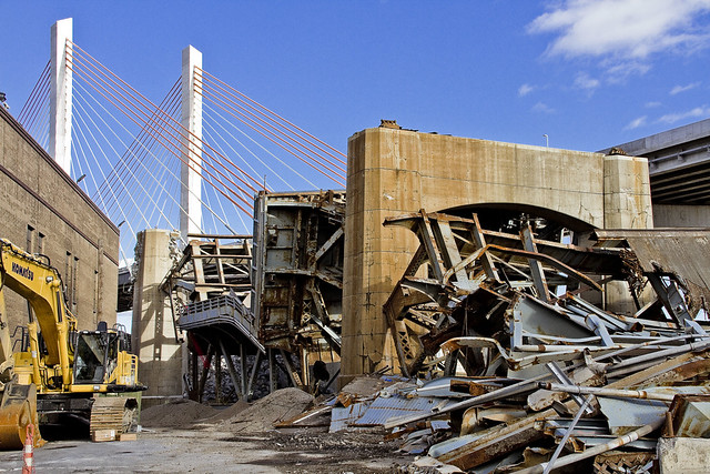
They’re still hard at work demolishing the rubble left behind by the “energetic felling” of the 1939 model Kosciuszcko Bridge at the start of October. These shots were captured from the hills of Calvary Cemetery, if you haven’t already figured that one out yet.

– photo by Mitch Waxman
The reinforced concrete piers that carried the roadway are being demolished using traditional means. That involves the yellow thingamabob being equipped with a chisel hammer, and the guy on the orange lift is spraying water on the concrete to mitigate dust.
The shots of the Queens side of DUKBO in today’s post were shot on November 17th, a Friday.

– photo by Mitch Waxman
On the following Sunday the 19th, a humble narrator scuttled over to the Poison Cauldron in Greenpoint.
That’s my pet name for the section of DUKBO that begins at Kingsland Avenue and heads east past Meeker Avenue to the National Grid fencelines at Lombardy Street. It’s ugly in the Poison Cauldron, I tell you, ugly. Things can’t “get from bad to worse” because they’re already there.

– photo by Mitch Waxman
Similar industrial demolition and scrap removal practices to those in Queens are also occurring on the Brooklyn side. Unlike the Queens side, however, I was able to walk right up to and on the job site. I even used one of the Porta Potties they had stationed to blow some internal ballast (hey, it’s a fairly long walk from Astoria).
– photo by Mitch Waxman
It is odd for me to see light in this spot… this was always an area permeated by shadows, which I now long for.
Additionally, not being chased, threatened, or harassed by the questionable managers of a local waste transfer station as to “whatchu takin pictchas of asshole, getdafukouttaherre” – said operation having been displaced by the construction activity – was not missed at all.

– photo by Mitch Waxman
The only thing going through my mind was that this scene looked like a battle had been fought here.

– photo by Mitch Waxman
I’m sure I’ll have a bit more to tell you about the Kosciuszcko Bridge shortly, as there’s supposed to be a meeting of the Stakeholders Committee coming up in early December.

– photo by Mitch Waxman
There was only so far I wanted to go, as this was and is an active demolition site.
Luckily, that’s what zoom lenses are for.

– photo by Mitch Waxman
The things you see along the Newtown Creek…

– photo by Mitch Waxman
… if you don’t take pictures of them, nobody would believe you.
How can such a place be real, and that so few people even know it exists, this omphalos of New York City?
Upcoming Tours and events
Calvary Cemetery Walking Tour, with Atlas Obscura – Sunday, December 10th, 11 a.m. – 1 p.m.
Explore NYC history, hidden inside sculptural monuments and mafioso grave sites, as you take in iconic city views on this walking tour, with Newtown Creek Alliance Historian Mitch Waxman – details here.
“follow” me on Twitter- @newtownpentacle
self styled
It’s National Pickle Day, in these United States.

– photo by Mitch Waxman
A variety of obligations and impediments have caused one to come up short on content this week. As is my custom, accordingly, whilst a humble narrator is out perambulating about the great city seeking to ameliorate his shortcomings – single shots which I like for one reason or another will be presented at this – your Newtown Pentacle.
Pictured above – a shot of the Brooklyn Bridge as seen from the East River.
Upcoming Tours and events
Calvary Cemetery Walking Tour, with Atlas Obscura – Sunday, December 10th, 11 a.m. – 1 p.m.
Explore NYC history, hidden inside sculptural monuments and mafioso grave sites, as you take in iconic city views on this walking tour, with Newtown Creek Alliance Historian Mitch Waxman – details here.
“follow” me on Twitter- @newtownpentacle
quiet removal
It’s National Boston Creme Pie Day, in these United States.

– photo by Mitch Waxman
If you want to know what the end of the world looks like, I can take you there. It’s about 3.8 miles from the East River, in an area of Brooklyn that is clearly Bushwick but which the real estate people refer to as East Williamburg. The end of the world is surrounded by heavy industry and waste transfer stations, and is crossed by a railroad bridge. It’s defined by a waterbody called English Kills, which is a dead end tributary of the fabulous Newtown Creek.
Just last week, a visit was paid to this paradise of nihilism.

– photo by Mitch Waxman
The open sewers are just one of the apocalyptic factors back here, as is the enormous waste transfer station operated by a transnational conglomerate that handles about a third of the black bag (or putrescent) garbage collected by the Department of Sanitation. There is virtually zero laminar flow to the water here, which means that the rising and falling of the tide is a vertical affair rather than a horizontal one, creating stinking shoals along the banks and allowing sediment mounds to rise from the channel. It often smells like rubber cement thinner along this stretch of English Kills, the waters are greasy, and they commonly exhibit an uncommon and unnatural coloration highlighted by patches of weird iridescence.
Men and women seem to become possessed by the spirit of the place, wildly dumping garbage into the shallows with a gleeful abandon.

– photo by Mitch Waxman
References in the historical record refer to distinct periods in English Kills’ existential course. Once, a mostly fresh water stream fed by the springs and streams of a Bushwick that drew German beer Brewers to the area, which bled sweet water into the main body of Newtown Creek, just a decade after the American Civil War English Kills began to be described as the “industrial canals of Brooklyn.” By the time that the Army Corps of Engineers oversaw the WW1 era shaping of the Newtown Creek watershed into something we would recognize on a google map in modernity, English Kills had open pipes carrying industrial and chemical waste products into the water from acid factories and the other dirty industries surrounding it. The upland springs and steams which drew the brewers here were paved over or turned into sewers, and the only naturally occurring liquid entering the narrow channel afterwards was a tepid trickle of brackish East River water (which was itself terribly compromised) weakly pulsing in with the daily tide, or storm runoff from the streets.
Brooklyn legend suggests this area was used as a graveyard by mobsters, but that’s just a legend. Gangsters dump bodies into fast moving or oceanic water bodies like Jamaica Bay or the Hudson River. The idea is to get rid of the evidence, not to leave something incriminating in a place where it can be found.
Whatever enters English Kills stays in English Kills.

– photo by Mitch Waxman
The structure pictured above is the Montrose Avenue Railroad Bridge, part of the Bushwick Branch lead tracks of the Long Island Ralroad. The bridge, and adjacent fencelines, are covered in odd graffiti which is in English but drawn with characters that betray a runic influence. The screeds warn of witches and other mythological creatures.
This is what the end of the world looks like, if… like me… the borders of your world are defined and bisected by that lugubrious ribbon of urban neglect known as the Newtown Creek.
Upcoming Tours and events
Exploring Long Island City, from Luxury Waterfront to Abandoned Factories Walking Tour,
with NY Adventure Club – Sunday, November 12th, 2:30 p.m. – 4:30 p.m.
Long Island City is a tale of two cities; one filled with glittering water-front skyscrapers and manicured parks, and the other, a highly active ground transportation & distribution zone vital to the New York economy — which will prevail? With Newtown Creek Alliance Historian Mitch Waxman – details here.
“follow” me on Twitter- @newtownpentacle


