Posts Tagged ‘Long Island City’
serious citizens
It’s National Rice Pudding Day, in these United States.

– photo by Mitch Waxman
My quest to observe and photograph certain rumored artifacts, carefully hidden by the administration of Queens Borough President Curly Joe Cassidy in 1903, which an anonymous source informed me were recently uncovered by the labor of construction crews that were pursuing the lustful ambitions of their Manhattan based masters (to erect yet another bland residential tower here in Western Queens) was fruitless. Some things, it would seem, will remain hidden.
Perhaps that is for the best, for if the community as a whole was to ever truly understand the history of Long Island City… anarchy and red rage would reign as they abandoned all pretense of civilization. Men would become wild and mad, without moral convention or law, and they would would find new and savage ways to enjoy themselves, abandoning even “lip service” allegiance to that extraterrestrial thing which they once referred to as “God.”
Defeated, aimless, lost in ennui and abandoned by serendipity… a wandering mendicant and humble narrator soon found himself, like every other piece of wind blown trash in New York City, at the Newtown Creek. The Dutch Kills tributary of Newtown Creek in the Long Island City section of Queens, specifically.

– photo by Mitch Waxman
Dutch Kills was in a queer condition this particular late afternoon in the August of 2017. The burning thermonuclear eye of God itself hung squamous in the sky, occluded by vast gray and white agglutinations of atmospheric humidity. Recent rain had enriched the nutrient load of the water with raw sewage, causing a bloom of the photosynthetic organisms which feed on both fecund decay and the eye’s emanations. Within a few days, these single celled plants would choke themselves to death on their respiratory waste gases, and the water will turn brown as bacterial populations explode while consuming their corpses. The bacteria produce a waste gas which men call hydrogen sulfide, offering to passers by an aroma not unlike that of rotting eggs. A few days later the water will blacken as the self same bacteria, in turn, are killed off by starvation and asphyxiation. Their rotting colonies will in turn feed a new generation of algae, which will overpopulate when the rain again brings the sewer tide and the cycle begins anew.
The smell of the green creek is onerous and inescapable, and the brown creek is something else entirely. The stink of the black creek… let’s just call that “unusual.” It’s all very depressing, where unwholesomeness reigns.
A smell reminiscent of swamp dwelling reptiles was omnipresent on the day these photos were collected.

– photo by Mitch Waxman
Dutch Kills was choked with 19th century industrial waste products and mounds of manure produced by pack animals when Michael Degnon began construction on the flooded waste meadows formerly owned by Governor Roscoe P. Flowers, back in 1909. Filling in the swamps with rocky till harvested from the subway and railroad tunnels his company constructed, Degnon’s goal was to build the greatest industrial park in the country hereabouts. The Degnon Terminal promised lots of sufficient size to construct enormous factory buildings, like the Loose Wiles “Thousand Windows Bakery,” as well as offering terrestrial railroad and “rail to barge” connections. Dutch Kills was bulkheaded under the supervision of the Army Corps of Engineers, it’s wetlands filled in, and industry was invited into “America’s Workshop.”
Borough President Maurice E. Connolly located his offices alongside Degnon’s, in what modernity refers to as the “Paragon Oil Building” on 21st street and 49th avenue, but which was built as the “Subway Building” and served Connolly as his Borough Hall.

– photo by Mitch Waxman
Maurice E. Connolly, like all the Borough Presidents of Queens, was presented at inauguration with a 1661 scrap of parchment left behind by William Hallet. Describing a degenerate offshoot of the Lenape civilization encountered in Western Queens, who were rumored to be members of a shunned cult repudiated and suppressed by the larger aboriginal civilization, this dark knowledge is a closely guarded state secret which has been passed from leader to leader since the early Calvinist era of the Dutch colony of Nieuwtown. As far as I’ve been able to discern, the Borough Presidents of Queens have faithfully maintained the ignorance of Mayors and Governors, and that even the executive branch of neighboring Brooklyn is unaware of what the ancient message transmits.
What the document says about these Native American devil worshippers is known only by the intended recipients, but that soon after reading it, Connolly began allocating funding to a vast swamp draining and land reclamation project in Queens. He installed miles of sewer pipes in pursuance of draining western Queens, many of which lead directly into Dutch Kills (accusations and convictions for corruption related to this effort are what finally removed him from office, after 17 years, in 1928).

– photo by Mitch Waxman
On the day these shots were captured, a bizarre amalgam of floatable items were observed in the solute rich compound which we will simply refer to as “water” for simplicity’s sake. Frizzled and black, these buoyant items were observed floating along on the tepid currents of Dutch Kills. It was a fairly low moment in the tidal cycle, but the start of the flood tide cycle was pushing in from the main spur of the Newtown Creek, and the black polyploid objects were meandering north towards the turning basin.
A zoom lens was employed, in pursuance of getting a closer look at the mysterious flotilla.

– photo by Mitch Waxman
Whatever the material of ebon hue was remains a mystery to me. I can report that there were odd streaks, as carried to the surface on bubbles of biological gas rising from subaqueous depths, of oil and coal tar present.
Who can guess what secrets might be hidden in the sediments beds of black mayonnaise, where all the sins of the twentieth century reside and mingle?
Upcoming Tours and events
Brooklyn Waterfront Boat Tour, with Working Harbor Committee – Saturday August 12th, 6 p.m. – 8 p.m.
Explore the coastline of Brooklyn from Newtown Creek to Sunset Park, with NCA Historian Mitch Waxman, Andrew Gustafson of Turnstile Tours, and Gordon Cooper of Working Harbor Committee on the narrating about Brooklyn’s industrial past and rapidly changing present. – details here.
The Poison Cauldron of the Newtown Creek Walking Tour, with Newtown Creek Alliance – Sunday August 13th, 11 a.m. – 1:30 p.m.
Explore the hellish waste transfer and petroleum districts of North Brooklyn on this daring walk towards the doomed Kosciuszko Bridge, with NCA Historian Mitch Waxman – details here.
Two Newtown Creek Boat Tours, with Newtown Creek Alliance and Open House NY – Wednesday August 16th, 5 p.m. and 7 p.m.
The neighborhoods surrounding Newtown Creek are home to the densest collection of these garbage facilities anywhere in the city and collectively, the waste transfer stations around and along Newtown Creek handle almost 40% of the waste that moves through New York. Join Newtown Creek Alliance’s Mitch Waxman and Willis Elkins to learn about the ongoing efforts to address the environmental burden that this “clustering” has caused. – details here.
DUPBO Newtown Creek Walking Tour, with NYCH20 – Thursday August 24th, 7 p.m. – 9 p.m.
Explore Greenpoint and Hunters Point, with NCA Historian Mitch Waxman – details here.
“follow” me on Twitter- @newtownpentacle
deemed needful
It’s International Beer Day, on this planet.

– photo by Mitch Waxman
One had received word that a recent excavation, committed in pursuance of a new tower construction project in Long Island City, had unearthed certain forbidden artifacts which had been interred back during the Borough Presidency of Curly Joe Cassidy in 1903. After his inauguration as BP, Curly Joe knew implicitly that then there are certain facts which, if disseminated to a wide audience and commonly known by the populace, might spark the dawning of a new dark age in which men would abandon all pretense of civilization and embrace their inner and atavist savage nature.
All the Borough Presidents of Queens, on the day of their inauguration, are required to read an ancient message, contained on a worm eaten scrap of parchment inscribed by William Hallet back in 1661, a document which is rumored to transmit the lore of a degenerate offshoot of the Lenape Nation and warn of the elder devils whom they both worshipped and reviled. No one but the Borough President of Queens is allowed to read this document, and they will all deny its existence. Melinda Katz won’t discuss the subject, and instead refers petitioners to the archivists at the Queens Library branch in Jamaica. For some, this hidden knowledge is too much to bear.
Why do you think Donald Manes really committed suicide back in the 1980’s?

– photo by Mitch Waxman
Along the path I picked to pursue the rumor of centuried artifacts unearthed by the Real Estate Industrial Complex, one encountered further evidences of the Queens Cobbler. For several years, the single shoe phenomena has been discussed at this – your Newtown Pentacle – and the theory that these individual shoes are gruesome taunts left on the public way to torment the Detectives of the 108th and 114th precincts by a serial killer has been advanced before.
This serial killer of men and women has been assigned the cognomen “Queens Cobbler” by this publication. Just as with the parchment scroll of hidden knowledge passed through the generations of Borough Presidents, the government will deny the presence or crimes of the Queens Cobbler.

– photo by Mitch Waxman
Despite this, the single shoes scattered around the neighborhoods surrounding the Newtown Creek and the buried wetlands of Sunswick Creek tell a different story. Legend has it that there’s a storage room found in an industrial section which hosts a perverse inventory of blood spattered materials, and that one of the local food carts is serving human meat souvlaki. Long Island City is a metropolis of secrets, and always has been.
The monstrous realities of what the Pennsylvania Rail Road engineers uncovered nearby the former grist mill of Burger Jorrissen a century ago – constructing the foundations of the Sunnyside Yards – while reclaiming the flood plains of the “waste meadows,” was skillfully hidden and remained a closely guarded secret amongst those who encountered “it”. That’s why – when the modern day “East Side Access” project engineers accidentally stumbled into “it” they were taken aback and convened emergency meetings in both Albany and Washington, and why progress on the transit project is so behind schedule. Why do you think security is so tight at their job site?
There are things older than mankind which might be found in Western Queens, things that were mercifully buried during the age of glaciation, before which we humans are naught but insects scratching in the dirt. There’s a reason that the Lenape preferred to avoid the “bad water place,” as they called the area.

– photo by Mitch Waxman
My quest to discover the forbidden artifacts of Curly Joe Cassidy carried me across the concrete devastations towards the River of Sound (or East River if you must) and one soon found himself at the Hunters Point waterfront section in LIC, which has been rent asunder in recent decades by the actions of the Real Estate Industrial Complex and their dross amibitions.
There are things you’ll encounter hereabouts which cause one to wonder, and more than wonder, about all there is that might be hidden behind concrete wall and balustrades or lying buried in the tainted earth. One has always wondered if the chemical pollution found in the eluvial clay and sand matrix beneath the pavement is some sort of containment mechanism purposely laid down during the age of industry to tame those things which lurk in the hydraulic voids and forgotten masonry tunnels which lie beneath the streets awaiting discovery.
Upcoming Tours and events
Brooklyn Waterfront Boat Tour, with Working Harbor Committee – Saturday August 12th, 6 p.m. – 8 p.m.
Explore the coastline of Brooklyn from Newtown Creek to Sunset Park, with NCA Historian Mitch Waxman, Andrew Gustafson of Turnstile Tours, and Gordon Cooper of Working Harbor Committee on the narrating about Brooklyn’s industrial past and rapidly changing present. – details here.
The Poison Cauldron of the Newtown Creek Walking Tour, with Newtown Creek Alliance – Sunday August 13th, 11 a.m. – 1:30 p.m.
Explore the hellish waste transfer and petroleum districts of North Brooklyn on this daring walk towards the doomed Kosciuszko Bridge, with NCA Historian Mitch Waxman – details here.
Two Newtown Creek Boat Tours, with Newtown Creek Alliance and Open House NY – Wednesday August 16th, 5 p.m. and 7 p.m.
The neighborhoods surrounding Newtown Creek are home to the densest collection of these garbage facilities anywhere in the city and collectively, the waste transfer stations around and along Newtown Creek handle almost 40% of the waste that moves through New York. Join Newtown Creek Alliance’s Mitch Waxman and Willis Elkins to learn about the ongoing efforts to address the environmental burden that this “clustering” has caused. – details here.
DUPBO Newtown Creek Walking Tour, with NYCH20 – Thursday August 24th, 7 p.m. – 9 p.m.
Explore Greenpoint and Hunters Point, with NCA Historian Mitch Waxman – details here.
“follow” me on Twitter- @newtownpentacle
outspread under
It’s National Watermelon day, in these United States

– photo by Mitch Waxman
A sense of place is one of the things that I always keep in mind when I’m out shooting around Newtown Creek. Without a glimmer of the skyline, in particular a recognizable silhouette like the Empire State Building, it’s impossible to say if you’re looking at NYC or just some post industrial landscape anywhere in the great American rust belt.
Saying all that, you’ve got to be careful about how much of the frame is filled by iconic architecture like Empire State as the people who own the building zealously defend a theoretical copyright on images in which it appears. If the shot above was to appear in an advertisement, for instance, a fee would need to be negotiated with the building’s management for usage of its image. The Empire State Building is like Brad Pitt or Beyoncé.

– photo by Mitch Waxman
One has been thinking about the ownership of reproduction rights over something that you can’t help but have occupy a certain proportion of shots captured whilst out in public. Back when I was a full time advertising retoucher, one of the most ridiculous assignments I received was to remove any and all identifiable “brands” from a series of stock photos. These photos were going to published in a direct mail offering for a large credit card company serviced by the agency, and the client didn’t want to negotiate with the various brand owners for usage. Therefore, one spent a week or so retouching every logo and identifiable brand image out of shots of Times Square, the Ginza strip, and Picadilly Circus.
The results were bizarre, and looked like something from the second act of a zombie movie, but the client was happy and I got paid… so… victory. I guess.

– photo by Mitch Waxman
Personally, since I’ve stepped behind the camera over the last decade or so, a point is made to frame my shots in such a manner as to necessitate as little retouching out of logos and brand marks as possible. As I always say to the creative types – check with the retoucher before the shoot if you want to save yourself a bunch of money.
Upcoming Tours and events
We’re cancelling Saturday the 5th’s Insalubrious Valley tour due to a forecast of scattered thunderstorms with lightning expected.
The Insalubrious Valley of the Newtown Creek Walking Tour, with Newtown Creek Alliance – Saturday August 5th, 11 a.m. – 1;30 p.m.
Century old movable bridges, the remains of a 19th century highway between Brooklyn and Queens, and explore two of the lesser known tributaries of the troubled Newtown Creek watershed. For the vulgarly curious, Conrad Wissell’s Dead Animal and Night Soil wharf will be seen and described, with NCA Historian Mitch Waxman – details here.
Brooklyn Waterfront Boat Tour, with Working Harbor Committee – Saturday August 12th, 6 p.m. – 8 p.m.
Explore the coastline of Brooklyn from Newtown Creek to Sunset Park, with NCA Historian Mitch Waxman, Andrew Gustafson of Turnstile Tours, and Gordon Cooper of Working Harbor Committee on the narrating about Brooklyn’s industrial past and rapidly changing present. – details here.
The Poison Cauldron of the Newtown Creek Walking Tour, with Newtown Creek Alliance – Sunday August 13th, 11 a.m. – 1:30 p.m.
Explore the hellish waste transfer and petroleum districts of North Brooklyn on this daring walk towards the doomed Kosciuszko Bridge, with NCA Historian Mitch Waxman – details here.
Two Newtown Creek Boat Tours, with Newtown Creek Alliance and Open House NY – Wednesday August 16th, 5 p.m. and 7 p.m.
The neighborhoods surrounding Newtown Creek are home to the densest collection of these garbage facilities anywhere in the city and collectively, the waste transfer stations around and along Newtown Creek handle almost 40% of the waste that moves through New York. Join Newtown Creek Alliance’s Mitch Waxman and Willis Elkins to learn about the ongoing efforts to address the environmental burden that this “clustering” has caused. – details here.
DUPBO Newtown Creek Walking Tour, with NYCH20 – Thursday August 24th, 7 p.m. – 9 p.m.
Explore Greenpoint and Hunters Point, with NCA Historian Mitch Waxman – details here.
“follow” me on Twitter- @newtownpentacle
unsigned letter
It’s National Drive-Thru Day, in these United States.
– photo by Mitch Waxman
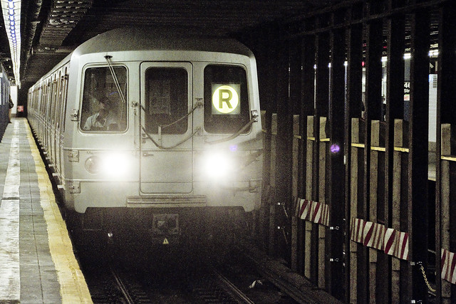
Ain’t nothing like a heat wave in NYC, huh? Regardless of tropical clime, nor distances involved, a humble narrator nevertheless surged forward into the wilds of Long Island’s western tip recently to gather photographs and experience the truculent realities of our time.
One left Point A in Astoria via the usual means, onboard the so called “R” or Broadway Local Line .
from wikipedia
The R Broadway Local is a rapid transit service in the B Division of the New York City Subway. Its route emblem, or “bullet”, is colored yellow since it uses the BMT Broadway Line in Manhattan.
The R operates local between 71st Avenue in Forest Hills, Queens and 95th Street in Bay Ridge, Brooklyn at all times except nights when it short turns at Whitehall Street–South Ferry in Lower Manhattan from Brooklyn.
– photo by Mitch Waxman
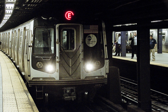
Ultimately, one sought to gain access to the Crosstown or “G” line, which the MTA folks annoyingly force one to enact two transfers to get to from Point A, despite the platform’s location less than a mile and a half from my starting point (and the fact that the G used to run through the same station which I caught the R at). Accordingly, at the sweltering bunker of dripping masonry which the MTA designates as “Queens Plaza,” one debarked the R and vouchsafed a single station ride upon the “E” – or Eighth Avenue Local Line – to the Court Square station where yet another transfer was enacted to access the G.
Urine, it smelled deeply of urine, at the Court Square station.
from wikipedia
The E Eighth Avenue Local is a rapid transit service in the B Division of the New York City Subway. Its route emblem, or “bullet”, is blue since it uses the IND Eighth Avenue Line in Manhattan.
The E operates at all times between Jamaica Center–Parsons/Archer in Jamaica, Queens, and Chambers Street–World Trade Center in Lower Manhattan, running express on the IND Queens Boulevard Line in Queens (except nights when it serves all stops) and local in Manhattan. E trains also serve two local stops in eastern Queens (75th Avenue and Briarwood) on evenings and weekends.

– photo by Mitch Waxman
My penultimate destination, on this particularly warm evening, was Sunset Park – which adjoins the legend choked streets of the Red Hook section of Brooklyn. One does realize, of course, that the R could have taken me all the way to this area which is called “Sunset Park,” but that would have multiplied my travel time due to a circuitous route which transverses all of Manhattan and a good chunk of Brooklyn.
The G discharged a humble narrator, vomiting me forth onto the platforms at the sky flung Smith/9th street station, high over the loathsome and shadow haunted Gowanus Canal. The Gowanus Canal smells of urine (and other things) as well, of course.
from wikipedia
The G Crosstown Local is an 11.4-mile-long (18.3 km) rapid transit service in the B Division of the New York City Subway. Its route emblem, or “bullet”, is colored light green since it uses the IND Crosstown Line.
The G operates at all times between Court Square in Long Island City, Queens and Church Avenue in Kensington, Brooklyn via the IND Crosstown and Culver lines. In Queens, it only serves two stations – Court Square and 21st Street, both in Long Island City – but previously served all stations to and from 71st Avenue in Forest Hills on the IND Queens Boulevard Line.
– photo by Mitch Waxman
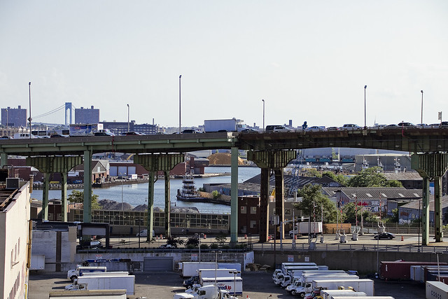
My plan was to pass through the “House of Moses” and under the Gowanus Expressway section of the Brooklyn Queens Expressway, exploiting the shaded path which is offered by this elevated roadway, and head south towards Sunset Park. It should be mentioned, incidentally, that this is perhaps the least pedestrian friendly area in all of Brooklyn. Brobigdagnian trucks whiz about at high speed, angry motorists lurch their vehicles to and fro in frustrated bursts, and the pavement is both shadowed by the expressway above and in a delitorious state of repair.
Also, there’s vampires hiding in the rafters of the Gowanus Expressway.
from nycroads.com
The Gowanus Expressway, which serves as the southern extension of the Brooklyn-Queens Expressway, also connects the Brooklyn-Battery Tunnel approach, the Prospect Expressway (NY 27), the Belt Parkway and the Verrazano-Narrows Bridge. Although guide signs and maps refer to this segment of I-278 as the Brooklyn-Queens Expressway, it is known locally as the Gowanus Expressway.
Beginning in 1939, Robert Moses oversaw construction of the Gowanus Parkway, an elevated highway placed on top of the pillars of the old 3rd Avenue BMT Elevated Line through the Sunset Park and Gowanus sections of Brooklyn. It would eventually become part of a limited-access parkway loop encircling four of the five boroughs. Since the Gowanus Parkway was to be constructed atop a pre-existing elevated facility, Moses had little trouble getting his project approved by the New York City Council.
However, the Gowanus Parkway would require more land for a wide roadway and entrance-exit ramps. This required the demolition of many homes and businesses along Third Avenue, a tightly knit block of Northern and Western European immigrants.

– photo by Mitch Waxman
There are charming sights to be found along the Gowanus Canal, I should mention, lest you think I’m prejudiced against the “Superfund Sister to the South” of my beloved Newtown Creek. Abundant waste transfer and oil distribution facilities, endemic pollution, lakes of unknown chemical constitution lurking just below the streets, untreated sewage oozing out of unmarked pipes? These are all the things I love.
One has never understood the appeal of “going to the country” and vacationing amongst the rural yokels. Camping? Are you insane? I’ve got a dry bed and a door that locks here in NYC, where I get to witness a looming infrastructure crisis and unfolding environmental apocalypse whenever I want to.
from wikipedia
The Gowanus Canal is a canal in the New York City borough of Brooklyn, on the westernmost portion of Long Island. Connected to Gowanus Bay in Upper New York Bay, the canal borders the neighborhoods of Red Hook, Carroll Gardens, and Gowanus, all within South Brooklyn, to the west; Park Slope to the east; Boerum Hill and Cobble Hill to the north; and Sunset Park to the south. It is 1.8 miles (2.9 km) long. There are seven bridges over the canal, carrying Union Street, Carroll Street (a landmark), Third Street, Ninth Street, Hamilton Avenue, the Gowanus Expressway, and the IND Culver Line of the New York City Subway.

– photo by Mitch Waxman
That’s part of the Gowanus Canal, pictured above, as shot from the Hamilton Avenue Bridge and looking back north towards the Smith/9th street station which the G line disgorged me into. Used as I am to the wild expanses and geographic extent of Newtown Creek, my thoughts always turn to compactness when I’m at the Gowanus. Thing is, just like Newtown Creek and its tributaries – two of which the Gowanus would tuck neatly into – the canal interacts with ground water and flows beneath the streets via its connections with the sewer system. Just like Newtown Creek, many of the sewers connected to the Gowanus are in fact former tributary waterways which were converted and buried at the end of the 19th and start of the 20th centuries. Who can guess, all there is, that might be buried down there?
Additionally, both Gowanus Canal and Newtown Creek sport maritime industrial bulkheads along most of their length which are little more than artifacts of the Second Industrial Age, in our modern day NYC.
from nyc.gov
The Hamilton Avenue Bridge is a bascule bridge with two parallel leafs, one carrying the northbound roadway and the other carrying the southbound roadway. Most of the length of Hamilton Avenue runs below the elevated portion of the Gowanus Expressway, including the bridge. The bridge connects Smith Street and Second Avenue over the Gowanus Canal and is the first canal crossing north of the Gowanus Bay.

– photo by Mitch Waxman
Regardless of musings about the wasted space, lack of public access, and utter degradation of the air, water, and soil – one had somewhere to be, and a little bit of walking was required to get there. A humble narrator put his head down, leaned into a southerly declination, and scuttled off into the clouds of auto exhaust mixing with the humid air.
The Gowanus Expressway dwelling Vampires be damned, I needed to get to Sunset Park.
from wikipedia
A vampire is a being from folklore that subsists by feeding on the life essence (generally in the form of blood) of the living. In European folklore, vampires were undead beings that often visited loved ones and caused mischief or deaths in the neighbourhoods they inhabited when they were alive. They wore shrouds and were often described as bloated and of ruddy or dark countenance, markedly different from today’s gaunt, pale vampire which dates from the early 19th century.
Vampiric entities have been recorded in most cultures; the term vampire, previously an arcane subject, was popularised in the West in the early 19th century, after an influx of vampire superstition into Western Europe from areas where vampire legends were frequent, such as the Balkans and Eastern Europe; local variants were also known by different names, such as shtriga in Albania, vrykolakas in Greece and strigoi in Romania. This increased level of vampire superstition in Europe led to mass hysteria and in some cases resulted in corpses being staked and people being accused of vampirism.
Upcoming Tours and events
The Insalubrious Valley of the Newtown Creek Walking Tour, with Newtown Creek Alliance – Saturday August 5th, 11 a.m. – 1;30 p.m.
Century old movable bridges, the remains of a 19th century highway between Brooklyn and Queens, and explore two of the lesser known tributaries of the troubled Newtown Creek watershed. For the vulgarly curious, Conrad Wissell’s Dead Animal and Night Soil wharf will be seen and described, with NCA Historian Mitch Waxman – details here.
Brooklyn Waterfront Boat Tour, with Working Harbor Committee – Saturday August 12th, 6 p.m. – 8 p.m.
Explore the coastline of Brooklyn from Newtown Creek to Sunset Park, with NCA Historian Mitch Waxman, Andrew Gustafson of Turnstile Tours, and Gordon Cooper of Working Harbor Committee on the narrating about Brooklyn’s industrial past and rapidly changing present. – details here.
The Poison Cauldron of the Newtown Creek Walking Tour, with Newtown Creek Alliance – Sunday August 13th, 11 a.m. – 1:30 p.m.
Explore the hellish waste transfer and petroleum districts of North Brooklyn on this daring walk towards the doomed Kosciuszko Bridge, with NCA Historian Mitch Waxman – details here.
Two Newtown Creek Boat Tours, with Newtown Creek Alliance and Open House NY – Wednesday August 16th, 5 p.m. and 7 p.m.
The neighborhoods surrounding Newtown Creek are home to the densest collection of these garbage facilities anywhere in the city and collectively, the waste transfer stations around and along Newtown Creek handle almost 40% of the waste that moves through New York. Join Newtown Creek Alliance’s Mitch Waxman and Willis Elkins to learn about the ongoing efforts to address the environmental burden that this “clustering” has caused. – details here.
“follow” me on Twitter- @newtownpentacle
quiet steps
It’s National Caviar Day, in these United States.

– photo by Mitch Waxman
The shot above was captured at the corner on the Astoria side of Northern Blvd. and 47th street, a couple of weeks ago. If it was shot a hundred years ago, this location would have been described as the corner of Jackson Avenue and 17th avenue (aka 19th century Oakley Street) nearby Long Island City’s border with Woodside. Back then, there would have been streetcars (trolleys) rolling through the shot. That’s the sort of thing which I wish the NYC EDC’s BQX team would think about – putting streetcars back where they belong, along these old routes currently serviced by MTA’s buses. This particular trolley route was one that rolled off the Queensborough Bridge, the New York and Queens County Railroad.
The street grid of modern day Sunnyside continued through to the north towards Astoria across what’s now the Sunnyside Yards and those huge used car dealerships you see in the shot above, which are found on the southern side of Northern Blvd. in modern times.

– photo by Mitch Waxman
Northern Blvd. is a widened version of Jackson Avenue, which is another one of the many road projects overseen by Robert Moses in the early 20th century. Another one of Mr. Moses’s projects was both the creation of the Grand Central Parkway (which fed traffic to his Triborough Bridge from Eastern Queens and Long Island) and the redesignation of Astoria Avenue into Astoria Blvd.
FDNY’s Engine 263 and Ladder 117 are housed in a consolidation era firehouse, pictured above, which predates the Grand Central’s construction. There’s a shot of the place from ca. 1920 you might be interested in perusing at this dcmny.org link which shows what things looked like back in the post WW1 period here in Western Queens. The historic shot looks west down Astoria Avenue towards Steinway Street.

– photo by Mitch Waxman
That’s the Long Island Rail Road as it rolls out of the 1870 vintage LIC Passenger Yard towards the Hunters Point Station. The incredible trainsarefun.com is an invaluable resource for studying this particular rail empire, and they offer this incredible aerial image from 1940 which shows the LIRR operation at probably its grandest moment.
Upcoming Tours and events
The Poison Cauldron of the Newtown Creek Walking Tour, with Atlas Obscura – July 22nd, 11 a.m. – 2 p.m..
Explore the hellish waste transfer and petroleum districts of North Brooklyn on this daring walk towards the doomed Kosciuszko Bridge, with NCA Historian Mitch Waxman – details here.
“follow” me on Twitter- @newtownpentacle


