Archive for the ‘East River’ Category
middle stature

– photo by Mitch Waxman
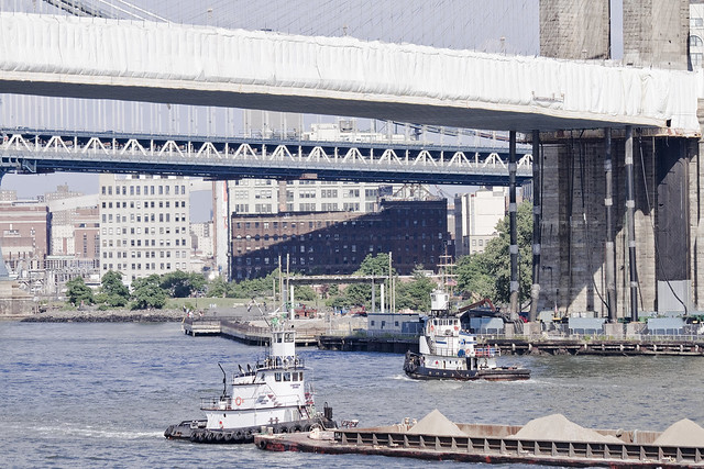
It’s Maritime Sunday once again at this, your Newtown Pentacle, and today the focus is on Thornton Towing’s 1600 HP and 1958 vintage “Thornton Bros.” tugboat. Call sign WDD6171, Thornton Bros. is some 25m x 8m in size and has been clocked going as fast as 8 knots.
from wikipedia
Merchant and naval vessels are assigned call signs by their national licensing authorities. In the case of states such as Liberia or Panama, which are flags of convenience for ship registration, call signs for larger vessels consist of the national prefix plus three letters (for example, 3LXY, and sometimes followed by a number, i.e. 3Lxy2). United States merchant vessels are given call signs beginning with the letters “W” or “K” while US naval ships are assigned callsigns beginning with “N”. Originally both ships and broadcast stations were given call signs in this series consisting of three or four letters, but as demand for both marine radio and broadcast call signs grew, gradually American-flagged vessels were given longer call signs with mixed letters and numbers.

– photo by Mitch Waxman
From what I’ve been able to determine, the actual Thornton Brothers are local boys, although I’ve never met them. The tug Thornton Bros., however, seems to spend a lot of time transporting bulk metals around the harbor. These are the same sort of barges which one often observes at SimsMetal at Newtown Creek, so one might presume that they are part of the “recycling industrial complex”.
from marinesteel.com
Thornton Towing & Transportation is owned by Gerard and Richard Thornton, and Ed Carr; all of whom have spent their entire professional careers working on and around the waters of New York Harbor.

– photo by Mitch Waxman
Originally launched as the John E. Matton, the tug has had a long career and undergone more than one change of ownership. As is maritime custom, each owner has leased the boat with a unique sobriquet, which is detailed by the always reliable folks at tugboatinformation.com in the link below.
Built in 1958, by Matton Shipyard of Cohoes, New York (hull #325) as the John E. Matton.
The Morania Oil Tanker corporation chartered the vessel and eventually purchased her, where she was renamed as the Morania No. 12 .
When Morania phased out their canal fleet and the Morania No. 12 was acquired by Reinauer Transportation of Staten Island, New York where she was renamed as the Cissi Reinauer .

– photo by Mitch Waxman
John Matton was a shipbuilder upstate, located in Cohoes NY. A largely forgotten industrial center, Cohoes was also a center of brick manufacturing and to this day- one can discern thousands of red bricks scattered along the Hudson River shoreline.
The tale begins in 1899. An enterprising boat builder by the name of John E. Matton opened a boat building and repair facility along the enlarged, mule-drawn Champlain Canal about three miles north of the Waterford side-cut. At the time, the ill-fated “$9 million improvement” of New York’s canals was on life support but still limping along against the backdrop of corruption and scandal in Albany. John E. Matton had no reason to expect that he would not be able to work out of his present location for years and years to come.
Just four years later, however, after Theodore Roosevelt had appointed a new commission to chart a future for New York’s canals, the Barge Canal Act was passed by the State Legislature and approved by New York voters. What would this mean for John E. Matton? That his facility would be utterly useless in a matter of years when the new Barge Canal was completed.
average specimens

– photo by Mitch Waxman
Captain Zeke is an 88 ton tug owned and operated by the White Near Coastal Towing Corp. of Syosset, and was built as the Lady Ora for Falgout Marine at Houma Shipbuilding in Louisiana back in 1980. Unfortunately, neither the company nor the tug have much information available about them, so there’s little more that can be said beyond its size- which is 30 m x 8 m, and its maximum recorded speed of 6.4 knots versus its average of 5.5 knots.
– photo by Mitch Waxman
Captain Zeke ran into a bit of trouble just a few years ago, on the Hudson River.
Spontaneous combustion involving paint rags in a fidley opening may have been the origin of the Aug. 31, 2008, fire aboard the Capt. Zeke, a Coast Guard investigator said. When their fire extinguishers proved inadequate, the tug crew fled to one of the barges.

– photo by Mitch Waxman
Speaking from a position of strictly deductive reasoning at this point, due to a lack of available information about this tug and its owners- Captain Zeke has been personally observed about the harbor moving small loads of a decidedly non volatile nature, as in the previous shot wherein the cargo seems to be sand.
It would be logical to assume that this role is well suited to the relatively small tug, which can most likely get into narrower spaces than the mated tug and barge gargantua which are employed by large players like Reinauer, Moran, or K-Sea (whose vessels specialize in the handling of volatiles) for the transport of various fuels and the handling of cargo vessels.
This theory is contradicted though, by this posting at the blog tuglife, which shows Captain Zeke tethered “on the hip” to a fuel barge.

– photo by Mitch Waxman
In the shots above and below, which were captured on the Kill Van Kull, Captain Zeke is tied to the sort of barge one regularly observes at Newtown Creek handling the SimsMetal trade in bulk metal. It is damnably odd, in the opinion of this humble narrator, that so little information is available online about this vessel. Normally, commercial maritime activity is copiously documented by a variety of private and government entities.
Regardless of this information vacuum, Newtown Pentacle’s “Maritime Sunday” nevertheless recognizes and sends a hearty greeting to Captain Zeke and its crew.
Magic Lantern Show in Ridgewood

Your humble narrator will be narrating humbly on Friday, February 24th at 7:30 P.M. for the “Ridgewood Democratic Club, 60-70 Putnam Avenue, Ridgewood, NY 11385” as the “Newtown Creek Magic Lantern Show” is presented to their esteemed group. The club hosts a public meeting, with guests and neighbors welcome, and say that refreshments will be served.
The “Magic Lantern Show” is actually a slideshow, packed with informative text and graphics, wherein we approach and explore the entire Newtown Creek. Every tributary, bridge, and significant spot are examined and illustrated with photography. This virtual tour will be augmented by personal observation and recollection by yours truly, with a question and answer period following.
For those of you who might have seen it last year, the presentation has been streamlined, augmented with new views, and updated with some of the emerging stories about Newtown Creek which have been exclusively reported on at this- your Newtown Pentacle.
For more information, please contact me here.
general tension
Note: I received a few corrections from Judy Berdy of the Roosevelt Island Historical Society on this post after it was published, special thanks for her generosity in sharing with us her vast knowledge. Please visit the link above for more on R.I.H.S.
My original statements, when “slashed” will be followed by corrections in red.
As always, when I get something wrong, corrections and additions are welcomed.

– photo by Mitch Waxman
Somehow, the Roosevelt Island Bridge has never been examined by this, your Newtown Pentacle.
An omission, but to be fair the tiny span is a bit overshadowed by it’s spectacular neighbors (Queensboro, Triborough, and Hellgate) and half hidden behind a power plant. Not content to leaving her standing at the edge of the ballroom any longer, lets invite her to the dance.
from nyc.gov
The Roosevelt Island Bridge is a tower drive, vertical lift, movable bridge across the East Channel of the East River between the borough of Queens and Roosevelt Island, New York City. The span length is 418 feet. It was known as the Welfare Island Bridge when it was first opened to traffic in 1955. The bridge is the only means of vehicular access to Roosevelt Island. Prior to construction, the bridge carried two 17-foot lanes of vehicular traffic and a 6-foot sidewalk. The bridge is used by both pedestrians and vehicles with increased volume during rush hours. The Queens approach begins at the intersection of Vernon Boulevard and 36th Avenue.

– photo by Mitch Waxman
Blackwell’s Island, later known as Welfare Island, was where you went when they “sent you up the river”.
both a regular commenter and R.I.H.S. disagree with me on “up the river” saying that it indicated Sing Sing prison and the river in question is the Hudson. Alternatively, I’ve got multiple references in the post revolutionary to civil war era that refers to Blackwell’s in this context.
The New York City government had a well established series of poor houses, prisons, and mental institutions here. Access to the island was strictly by boat until 21 years after the Queensboro bridge was erected in 1909, and an elevator system was built to carry trucks and other motor vehicles from its heights down to the Island in 1930 about 1916.
R.I.H.S. says: The Ferry Operated Until 1957 From 78 St And The FDR Drive.
This proved inadequate.
from nycroads.com
Initially, access to Welfare Island had been through a series of ferries from Manhattan and Queens. In 1930, a four-cab elevator service began between the lower deck of the Queensboro (59th Street) Bridge and the island. The service, which had served 230,000 cars per year by the early 1950’s, provided the only public connection to Welfare Island.
The increasing traffic needs to and from Welfare Island, as well as growing congestion on the Queensboro Bridge, prompted the New York City Department of Public Works to propose a new vertical-lift crossing between Queens and Welfare Island. After initial resistance from the New York City Council, which doubted that the $6.5 million span would carry enough traffic to justify its cost, construction of the Roosevelt Island Bridge (then named the Welfare Island Bridge) began on March 17, 1952.

– photo by Mitch Waxman
Hopelessly overcrowded and causing delays on Mighty Queensboro, the Depression era elevator system needed to be augmented.
Accordingly the City constructed the Welfare Island Bridge in 1955 to provide additional access. The elevator system on Queensboro stuck around for a few more years, but was eventually done away with around 1970.
Construction on the Welfare Island Bridge began in 1951.
from wikipedia
Roosevelt Island, known as Welfare Island from 1921 to 1973, and before that Blackwell’s Island, is a narrow island in the East River of New York City. It lies between the island of Manhattan to its west and the borough of Queens to its east. Running from Manhattan’s East 46th to East 85th streets, it is about two miles (3 km) long, with a maximum width of 800 feet (240 m), and a total area of 147 acres (0.59 km2). The island is part of the Borough of Manhattan (New York County). Together with Mill Rock, Roosevelt Island constitutes Manhattan’s Census Tract 238, which has a land area of 0.279 sq mi (0.72 km2). and had a population of 9,520 in 2000 according to the US Census. The Roosevelt Island Operating Corporation estimated its population was about 12,000 in 2007.

– photo by Mitch Waxman
Well known for excess and abuse, the institutional system on Welfare Island came crashing down in the years following the second world war, and was largely abandoned by the 1960’s, when the Manhattan establishment sought better uses for Welfare Island. There was a “branding” issue to be solved, of course, as “Welfare Island” was synonymous with “Mad House” and or “Prison” for several generations of New Yorkers.
R.I.H.S. says: Blackwell’s Island name was changed to Welfare Island in 1921. Welfare to roosevelt in 1973. The bad reputation came in the late 1800’s to 1920’s thereby changing name to Welfare Island.
In 1973, they decided to call it Roosevelt Island instead.
from freeclassicaudiobooks.com
In 1887 Nellie Bly, one of the first female newspaper writers, and a young reporter who would soon go on to make a career for herself as an investigative journalist and stunt reporter, had herself committed to the Blackwell’s Island Insane Asylum in New York. Her purpose was to discover what life was like for those who had been deemed insane. She was surprised to discover the depth of mistreatment of the patients. Partially as a result of her reporting, more money was allocated to the asylum and reforms were put into place.

– photo by Mitch Waxman
Like the nearby Pulaski Bridge over Newtown Creek, which was erected in the same era, Frederick H. Zurmuhlen of the Dept. of Public Works oversaw the design and construction of the Welfare Island Bridge. One of the unsung men who built the modern city, Zurmuhlen served under three mayors.
The Welfare Island Bridge opened, officially, on May 18, 1955.
from wikipedia
Roosevelt Island Operating Corporation was created by New York State in 1984 to manage development and operations of Roosevelt Island. Before RIOC there existed other state agencies which ran the island’s day-to-day operations such as the Welfare Island Development Corporation and later the Roosevelt Island Development Corporation. The first RIOC Board and President were appointed by the Governor in 1986.
The New York State Urban Development Corporation (UDC) operated New York City’s Welfare Island, as Roosevelt Island was previously known, prior to RIOC. Development of the island was based on the principles of urban “new communities” under President Lyndon Johnson’s “Great Society” programs of the 1960s and early 1970s, and development of the “new” community there was authorized by the 99-year ground lease and accompanying General Development Plan (GDP) agreed upon by New York City and New York State in 1969. The NY State GDP, which has been amended from time to time, provides for the development of housing, shops and community facilities for a mixed-income, handicap-accessible residential neighborhood.

– photo by Mitch Waxman
Of course, over on the Queens coast, the bridge has another overwhelming neighbor, the Ravenswood Power Plant- known to longtime New Yorkers simply as “Big Allis”.
for more on Big Allis check out this Newtown Pentacle posting from June of 2009-
“Big Allis is not in the Land of the Lost… or how I learned to stop worrying and love Ravenswood #3“

– photo by Mitch Waxman
The Welfare Island Bridge, known to modernity as the Roosevelt Island Bridge, has recently undergone a refurbishment and makeover. Much was made of the cosmetic improvements to the span, but the reality of the investment was a determination that in case of a seismic event- which the City of New York is long overdue for- the Bridge would suffer catastrophic damage.
A massive earthquake is one of the unspoken horrors which the City government has been quietly planning for, something which the Mayor’s office would be applauded for were it more widely known. A tip of the hat goes out to the municipal engineers and planners for both their discretion and the secretive work which they have been performing.
A highly technical description of NYC’s earthquake risk factors, prepared in 1998 by the NY State DOT, can be accessed here.
from wikipedia
Big Allis, formally known as Ravenswood No. 3, is a giant electric power generator originally commissioned by Consolidated Edison Company (ConEd) and built by the Allis-Chalmers Corporation in 1965. Currently owned by Transcanada Corp., it is located on 36th Avenue and Vernon Boulevard in western Queens, New York.
During 1963, Allis-Chalmers announced that ConEd had ordered the “world’s first MILLION-KILOWATT unit…big enough to serve 3,000,000 people.” This sheer scale helped the plant become popularly known as “Big Allis”.
At the time of its installation, it was the world’s largest steam energy generating facility. It is located on the Ravenswood site, consisting of Units 1, 2, 3 and 4, as well as several small Gas Turbines (GTs), and an oil depot. The site overall produces about 2,500 MW, or approximately 20% of New York City’s current energy needs. The current installed capacity of Big Allis is around 980 MW.

– photo by Mitch Waxman
The Roosevelt Island Bridge makes landfall on the Long Island at Vernon Avenue and 36th street, incidentally.
modern entrance

– photo by Mitch Waxman
Drink in the remaining scenery down in Long Island City while you can, lords and ladies, for the march of progress is indeed upon us. The initial phases of the Hunters Point South project, with myriad workers and clattering machinery, is under way. The first structure, a school, is rising from the dusty shoreline of Western Queens, and will soon obscure the shield wall of the Shining City itself.
Late in the second week of January, the estimable scions of Community Board 2 held a very well attended meeting at PS1 on Jackson Avenue, and your humble narrator was in attendance.

– photo by Mitch Waxman
Uncharacteristically, I sat quietly in the back of the room and merely observed the proceedings. The community of the so called “Tower Town” at the older Queens West development voiced concerns over the ratio of affordable versus market rate housing that would be included in the newer units which be appearing at the southernly edge of Hunters Point. Concerns about the already sparse level of community services- mass transportation, sewer capacity, schools, fire and police service- all were voiced in urgent, accusatory, and somewhat aggressive tones.
In attendance were City Councilmember Van Bramer, Assemblyperson Nolan, and representatives from the Mayors office and the Manhattan political establishment.
No comment is offered by your humble narrator.


